Bridge Statistics for Rosendale, New York (NY)
Condition, Traffic, Stress, Structural Evaluation, Project Costs
- National Bridge Inventory (NBI) Statistics
- 18Number of bridges
- 243ft / 73.7mTotal length
- $117,262,000Total costs
- 231,131Total average daily traffic
- 19,734Total average daily truck traffic
- National Bridge Inventory (NBI) Registered Bridges for Rosendale
- No street view available for this location
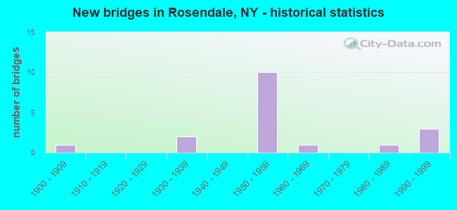
- New bridges - historical statistics
- 11900-1909
- 21930-1939
- 101950-1959
- 11960-1969
- 11980-1989
- 31990-1999

- Reconstructed bridges - Historical Statistics
- 11990-1999
- 12000-2009


- Bridge Condition - Deck
- 9.1%Good
- 54.5%Satisfactory
- 27.3%Fair
- 9.1%Poor

- Bridge Condition - Superstructure
- 8.3%Excellent
- 16.7%Good
- 33.3%Satisfactory
- 25.0%Fair
- 16.7%Poor

- Bridge Condition - Substructure
- 8.3%Excellent
- 16.7%Good
- 41.7%Satisfactory
- 16.7%Fair
- 16.7%Poor

- Bridge Condition - Channel
- 28.6%Very good
- 71.4%Satisfactory
Find on map >> Show street view
Structure Number: 10223, Location: JCT RT 32 & WALLKILL RIV (Lat: 41.815139, Lng: -74.058664), Route carried "on" structure: State highway 32, Year Built: 1933, Year Reconstructed: 1998, Status: Open, Structure Length: 6.58m (21.59ft), Average Daily Traffic: 8,372 (year 2012), Truck Traffic: 8%, Average Future Daily Traffic: 10,170 (year 2040), Design Load: HS 20, Features Intersected: WALKILL RIVER
Minimum Vertical Clearance: 4.47m (14.67ft), Kilometerpoint: 26.951, Lanes on structure: 2, Base Highway Network: Yes, Owner: State Highway Agency, Approaching Roadway Width: 9.1m (29.9ft), Skew: 3 degrees, Material/Design: Steel, Design/Construction: Truss - Thru, Number Of Spans In Main Unit: 1, Length of Maximum Span: 64.0m (210.0ft), Curb or Sidewalk Widths: Left: 0.0m, Right: 1.5m (4.9ft), Curb-To-Curb Width: 9.1m (29.9ft), Out-to-Out Width: 12.4m (40.7ft)
Condition: Deck: Satisfactory, Superstructure: Fair, Substructure: Fair, Channel: Satisfactory, Operating Rating: 63.5 metric tons, Method Used To Determine Operating Rating: Load Factor (LF), Inventory Rating: 38.1 metric tons, Method Used To Determine Inventory Rating: Load Factor (LF), Structural Evaluation: Somewhat better than minimum adequacy, Deck Geometry: Meets minimum limits, Waterway Adequacy: Meets minimum limits, Approach Roadway Alignment: Meets minimum limits, Length Of Structure Improvement: 6.58m (21.59ft), Designated Inspection Frequency: Every 24 months, Critical Feature Inspection Frequency: Every 24 months, Inspection Date: June 2021, Critical Feature Inspection Date: June 2021, Bridge Improvement Cost: $8,357,000, Roadway Improvement Cost: $4,894,000, Total Project Cost: $13,250,000 ( Estimate for 2021), Deck Structure Type: Concrete Cast-file-Place, Wearing Surface/Protective System: Wearing Surface: Integral Concrete, Deck Protection: Epoxy Coated Reinforcing
Find on map >> Show street view
Structure Number: 102231, Location: JCT RTE32+RONDOUT CR (Lat: 41.845792, Lng: -74.074272), Route carried "on" structure: State highway 32, Year Built: 1934, Year Reconstructed: 2009, Status: Open, Structure Length: 7.07m (23.20ft), Average Daily Traffic: 8,372 (year 2012), Truck Traffic: 8%, Average Future Daily Traffic: 10,170 (year 2040), Design Load: H 20, Features Intersected: RONDOUT CREEK
Minimum Vertical Clearance: 4.59m (15.06ft), Kilometerpoint: 30.909, Lanes on structure: 2, Base Highway Network: Yes, Owner: State Highway Agency, Approaching Roadway Width: 12.2m (40.0ft), Skew: 3 degrees, Material/Design: Steel, Design/Construction: Truss - Thru, Number Of Spans In Main Unit: 1, Length of Maximum Span: 70.1m (230.0ft), Curb or Sidewalk Widths: Left: 1.5m (4.9ft), Right: 1.5m (4.9ft), Curb-To-Curb Width: 9.1m (29.9ft), Out-to-Out Width: 9.6m (31.5ft)
Condition: Deck: Satisfactory, Superstructure: Poor, Substructure: Satisfactory, Channel: Very good, Operating Rating: 41.7 metric tons, Method Used To Determine Operating Rating: Load Factor (LF), Inventory Rating: 24.5 metric tons, Method Used To Determine Inventory Rating: Load Factor (LF), Structural Evaluation: Meets minimum limits, Deck Geometry: Meets minimum limits, Waterway Adequacy: Equal to present minimum criteria, Approach Roadway Alignment: Meets minimum limits, Length Of Structure Improvement: 7.07m (23.20ft), Designated Inspection Frequency: Every 24 months, Critical Feature Inspection Frequency: Every 12 months, Inspection Date: December 2021, Critical Feature Inspection Date: December 2021, Bridge Improvement Cost: $6,528,000, Roadway Improvement Cost: $3,823,000, Total Project Cost: $10,351,000 ( Estimate for 2021), Deck Structure Type: Concrete Cast-file-Place, Wearing Surface/Protective System: Wearing Surface: Monolithic Concrete, Deck Protection: Epoxy Coated Reinforcing
Find on map >> Show street view
Structure Number: 102232, Location: 1.9MI N JCT RTE32+ROND CR (Lat: 41.868567, Lng: -74.057822), Route carried "on" structure: State highway 32, Year Built: 1954, Status: Open, Structure Length: 8.60m (28.22ft), Average Daily Traffic: 7,236 (year 2017), Truck Traffic: 7%, Average Future Daily Traffic: 8,790 (year 2040), Design Load: H 20, Features Intersected: 87IX NB, RTE I87
Minimum Vertical Clearance: 30+ m (98+ ft), Kilometerpoint: 33.998, Lanes on structure: 2, Lanes under structure: 4, Base Highway Network: Yes, Owner: State Highway Agency, Maintenance Responsibility: State Toll Authority, Approaching Roadway Width: 12.8m (42.0ft), Skew: 4 degrees, Material/Design: Steel, Design/Construction: Stringer/Multi-beam, Number Of Spans In Main Unit: 4, Length of Maximum Span: 25.6m (84.0ft), Curb or Sidewalk Widths: Left: 0.8m (2.6ft), Right: 0.8m (2.6ft), Curb-To-Curb Width: 11.0m (36.1ft), Out-to-Out Width: 13.1m (43.0ft)
Condition: Deck: Poor, Superstructure: Good, Substructure: Poor, Operating Rating: 56.7 metric tons, Method Used To Determine Operating Rating: Load and Resistance Factor Rating (LRFR) rating reported by rating factor(RF) method using HL-93 loadings, Inventory Rating: 43.7 metric tons, Method Used To Determine Inventory Rating: Load and Resistance Factor Rating (LRFR) rating reported by rating factor(RF) method using HL-93 loadings, Structural Evaluation: Meets minimum limits, Deck Geometry: Meets minimum limits, Underclear: High priority of corrective action, Approach Roadway Alignment: Equal to present desirable criteria, Length Of Structure Improvement: 8.59m (28.18ft), Designated Inspection Frequency: Every 24 months, Inspection Date: August 2021, Bridge Improvement Cost: $4,439,000, Roadway Improvement Cost: $2,599,000, Total Project Cost: $7,038,000 ( Estimate for 2021), Deck Structure Type: Concrete Cast-file-Place, Wearing Surface/Protective System: Wearing Surface: Bituminous
Find on map >> Show street view
Structure Number: 104116, Location: 5.3 MI E JCT RTS 213 &209 (Lat: 41.839678, Lng: -74.106631), Route carried "on" structure: State highway 213, Year Built: 1997, Status: Open, Structure Length: 7.16m (23.49ft), Average Daily Traffic: 4,339 (year 2019), Truck Traffic: 6%, Average Future Daily Traffic: 4,526 (year 2040), Design Load: HS 25 or greater, Features Intersected: RONDOUT CREEK
Minimum Vertical Clearance: 30+ m (98+ ft), Kilometerpoint: 20.531, Lanes on structure: 2, Base Highway Network: Yes, Owner: State Highway Agency, Approaching Roadway Width: 10.4m (34.1ft), Skew: 2 degrees, Material/Design: Steel continuous, Design/Construction: Stringer/Multi-beam, Number Of Spans In Main Unit: 2, Length of Maximum Span: 35.0m (114.8ft), Curb-To-Curb Width: 10.4m (34.1ft), Out-to-Out Width: 11.0m (36.1ft)
Condition: Deck: Satisfactory, Superstructure: Satisfactory, Substructure: Good, Channel: Very good, Operating Rating: 78.9 metric tons, Method Used To Determine Operating Rating: Load Factor (LF), Inventory Rating: 36.3 metric tons, Method Used To Determine Inventory Rating: Load Factor (LF), Structural Evaluation: Equal to present minimum criteria, Deck Geometry: Somewhat better than minimum adequacy, Waterway Adequacy: Equal to present minimum criteria, Approach Roadway Alignment: Equal to present minimum criteria, Length Of Structure Improvement: 7.16m (23.49ft), Designated Inspection Frequency: Every 24 months, Inspection Date: July 2021, Bridge Improvement Cost: $3,671,000, Roadway Improvement Cost: $2,150,000, Total Project Cost: $5,821,000 ( Estimate for 2021), Deck Structure Type: Concrete Cast-file-Place, Wearing Surface/Protective System: Wearing Surface: Integral Concrete, Deck Protection: Epoxy Coated Reinforcing
Find on map >> Show street view
Structure Number: 334677, Location: 0.5 MI SE OF HIGH FALLS (Lat: 41.821256, Lng: -74.118897), Route carried "on" structure: Other road , Year Built: 1986, Status: Open, Structure Length: 1.92m (6.30ft), Average Daily Traffic: 92 (year 2017), Truck Traffic: 8%, Average Future Daily Traffic: 129 (year 2037), Design Load: HS 20+Mod, Features Intersected: COXING KILL, Facility Carried by Structure: SCHOOL HILL ROAD
Minimum Vertical Clearance: 30+ m (98+ ft), Kilometerpoint: 0.547, Lanes on structure: 2, Owner: County Highway Agency, Approaching Roadway Width: 7.9m (25.9ft), Material/Design: Prestressed concrete, Design/Construction: Box Beam or Girders - Multiple, Number Of Spans In Main Unit: 1, Length of Maximum Span: 17.6m (57.7ft), Curb-To-Curb Width: 7.9m (25.9ft), Out-to-Out Width: 8.9m (29.2ft)
Condition: Deck: Good, Superstructure: Satisfactory, Substructure: Satisfactory, Channel: Satisfactory, Operating Rating: 81.0 metric tons, Method Used To Determine Operating Rating: Load and Resistance Factor Rating (LRFR) rating reported by rating factor(RF) method using HL-93 loadings, Inventory Rating: 56.4 metric tons, Method Used To Determine Inventory Rating: Load and Resistance Factor Rating (LRFR) rating reported by rating factor(RF) method using HL-93 loadings, Structural Evaluation: Equal to present minimum criteria, Deck Geometry: Equal to present minimum criteria, Waterway Adequacy: Meets minimum limits, Approach Roadway Alignment: Equal to present desirable criteria, Length Of Structure Improvement: 1.92m (6.30ft), Designated Inspection Frequency: Every 24 months, Inspection Date: August 2021, Bridge Improvement Cost: $494,000, Roadway Improvement Cost: $289,000, Total Project Cost: $783,000 ( Estimate for 2021), Wearing Surface/Protective System: Wearing Surface: Integral Concrete
Find on map >> Show street view
Structure Number: 334704, Location: 1.0 MI NE OF HIGH FALLS (Lat: 41.830614, Lng: -74.110350), Route carried "on" structure: Other road , Year Built: 1966, Status: Open, Structure Length: 2.68m (8.79ft), Average Daily Traffic: 964 (year 2017), Truck Traffic: 3%, Average Future Daily Traffic: 1,350 (year 2037), Features Intersected: COXING KILL, Facility Carried by Structure: MOSSY BROOK RD
Minimum Vertical Clearance: 30+ m (98+ ft), Kilometerpoint: 2.043, Lanes on structure: 2, Owner: County Highway Agency, Approaching Roadway Width: 7.3m (24.0ft), Skew: 1 degrees, Material/Design: Steel, Design/Construction: Stringer/Multi-beam, Number Of Spans In Main Unit: 1, Length of Maximum Span: 25.2m (82.7ft), Curb-To-Curb Width: 7.3m (24.0ft), Out-to-Out Width: 8.2m (26.9ft)
Condition: Deck: Fair, Superstructure: Poor, Substructure: Satisfactory, Channel: Satisfactory, Operating Rating: 77.1 metric tons, Method Used To Determine Operating Rating: Load Factor (LF), Inventory Rating: 46.3 metric tons, Method Used To Determine Inventory Rating: Load Factor (LF), Structural Evaluation: Meets minimum limits, Deck Geometry: Meets minimum limits, Waterway Adequacy: Superior to present desirable criteria, Approach Roadway Alignment: Meets minimum limits, Length Of Structure Improvement: 2.68m (8.79ft), Designated Inspection Frequency: Every 24 months, Inspection Date: September 2021, Bridge Improvement Cost: $1,496,000, Roadway Improvement Cost: $876,000, Total Project Cost: $2,372,000 ( Estimate for 2021), Deck Structure Type: Concrete Cast-file-Place, Wearing Surface/Protective System: Wearing Surface: Bituminous
Find on map >> Show street view
Structure Number: 334746, Location: AT ROSENDALE (Lat: 41.842867, Lng: -74.085289), Route carried "on" structure: County highway , Year Built: 1957, Status: Open, Structure Length: 4.79m (15.72ft), Average Daily Traffic: 1,329 (year 2016), Truck Traffic: 4%, Average Future Daily Traffic: 1,644 (year 2040), Design Load: H 20, Features Intersected: RONDOUT CREEK, Facility Carried by Structure: COUNTY ROUTE 007
Minimum Vertical Clearance: 30+ m (98+ ft), Kilometerpoint: 2.188, Lanes on structure: 2, Owner: County Highway Agency, Approaching Roadway Width: 9.1m (29.9ft), Skew: 1 degrees, Material/Design: Steel, Design/Construction: Stringer/Multi-beam, Number Of Spans In Main Unit: 1, Number Of Approach Spans: 1, Length of Maximum Span: 38.7m (127.0ft), Curb or Sidewalk Widths: Left: 1.5m (4.9ft), Right: 1.5m (4.9ft), Curb-To-Curb Width: 9.1m (29.9ft), Out-to-Out Width: 12.8m (42.0ft)
Condition: Deck: Fair, Superstructure: Fair, Substructure: Poor, Channel: Satisfactory, Operating Rating: 55.3 metric tons, Method Used To Determine Operating Rating: Load Factor (LF), Inventory Rating: 32.7 metric tons, Method Used To Determine Inventory Rating: Load Factor (LF), Structural Evaluation: Meets minimum limits, Deck Geometry: Somewhat better than minimum adequacy, Waterway Adequacy: Superior to present desirable criteria, Approach Roadway Alignment: Meets minimum limits, Length Of Structure Improvement: 4.78m (15.68ft), Designated Inspection Frequency: Every 24 months, Inspection Date: October 2020, Bridge Improvement Cost: $3,695,000, Roadway Improvement Cost: $2,164,000, Total Project Cost: $5,858,000 ( Estimate for 2021), Deck Structure Type: Concrete Cast-file-Place, Wearing Surface/Protective System: Wearing Surface: Bituminous
Find on map >> Show street view
Structure Number: 551541, Location: 0.8 MI W OF TILLSON (Lat: 41.830994, Lng: -74.057558), Route carried "on" structure: Other road , Year Built: 1953, Status: Open, Structure Length: 6.22m (20.41ft), Average Daily Traffic: 230 (year 2019), Truck Traffic: 4%, Average Future Daily Traffic: 322 (year 2039), Design Load: HS 20, Features Intersected: 87I NB, RTE I87, Facility Carried by Structure: GRIST MILL ROAD
Minimum Vertical Clearance: 30+ m (98+ ft), Kilometerpoint: 0.676, Lanes on structure: 2, Lanes under structure: 4, Owner: State Toll Authority, Approaching Roadway Width: 7.0m (23.0ft), Skew: 1 degrees, Material/Design: Steel, Design/Construction: Stringer/Multi-beam, Number Of Spans In Main Unit: 4, Length of Maximum Span: 18.0m (59.1ft), Curb or Sidewalk Widths: Left: 0.7m (2.3ft), Right: 0.7m (2.3ft), Curb-To-Curb Width: 7.9m (25.9ft), Out-to-Out Width: 10.1m (33.1ft)
Condition: Deck: Satisfactory, Superstructure: Good, Substructure: Satisfactory, Operating Rating: 85.3 metric tons, Method Used To Determine Operating Rating: Load Factor (LF), Inventory Rating: 50.8 metric tons, Method Used To Determine Inventory Rating: Load Factor (LF), Structural Evaluation: Equal to present minimum criteria, Deck Geometry: Somewhat better than minimum adequacy, Underclear: High priority of corrective action, Approach Roadway Alignment: Equal to present desirable criteria, Length Of Structure Improvement: 6.21m (20.37ft), Designated Inspection Frequency: Every 24 months, Inspection Date: July 2020, Bridge Improvement Cost: $2,407,000, Roadway Improvement Cost: $1,410,000, Total Project Cost: $3,817,000 ( Estimate for 2021), Deck Structure Type: Concrete Cast-file-Place, Wearing Surface/Protective System: Wearing Surface: Monolithic Concrete
Find on map >> Show street view
Structure Number: 5515429, Location: I87 OVER ROUNDOUT CREEK (Lat: 41.852031, Lng: -74.059306), Route carried "on" structure: Interstate 87, Year Built: 1953, Status: Open, Structure Length: 16.61m (54.49ft), Average Daily Traffic: 32,350 (year 2018), Truck Traffic: 18%, Average Future Daily Traffic: 54,781 (year 2040), Design Load: HS 20+Mod, Features Intersected: RONDOUT CREEK
Minimum Vertical Clearance: 30+ m (98+ ft), Kilometerpoint: 28.431, Lanes on structure: 4, Base Highway Network: Yes, Toll: On Interstate toll segment, Owner: State Toll Authority, Approaching Roadway Width: 34.1m (111.9ft), Skew: 32 degrees, Material/Design: Steel continuous, Design/Construction: Girder and Floorbeam System, Number Of Spans In Main Unit: 4, Length of Maximum Span: 46.6m (152.9ft), Curb-To-Curb Width: 33.4m (109.6ft), Out-to-Out Width: 34.4m (112.9ft)
Condition: Deck: Satisfactory, Superstructure: Satisfactory, Substructure: Good, Channel: Satisfactory, Operating Rating: 72.6 metric tons, Method Used To Determine Operating Rating: Load Factor (LF), Inventory Rating: 43.5 metric tons, Method Used To Determine Inventory Rating: Load Factor (LF), Structural Evaluation: Equal to present minimum criteria, Deck Geometry: Superior to present desirable criteria, Waterway Adequacy: Superior to present desirable criteria, Approach Roadway Alignment: Equal to present desirable criteria, Length Of Structure Improvement: 16.61m (54.49ft), Designated Inspection Frequency: Every 24 months, Critical Feature Inspection Frequency: Every 24 months, Inspection Date: May 2020, Critical Feature Inspection Date: May 2020, Bridge Improvement Cost: $22,323,000, Roadway Improvement Cost: $13,072,000, Total Project Cost: $35,396,000 ( Estimate for 2021), Deck Structure Type: Concrete Cast-file-Place, Wearing Surface/Protective System: Wearing Surface: Bituminous, Membrane: Other, Deck Protection: Epoxy Coated Reinforcing
Find on map >> Show street view
Structure Number: 5515439, Location: 0.4 N JCT I-87< RONDOUT R (Lat: 41.857492, Lng: -74.058064), Route carried "on" structure: Interstate 87, Year Built: 1955, Status: Open, Structure Length: 2.50m (8.20ft), Average Daily Traffic: 32,350 (year 2018), Truck Traffic: 18%, Average Future Daily Traffic: 54,781 (year 2040), Design Load: HS 20+Mod, Features Intersected: COUNTY ROAD 25
Minimum Vertical Clearance: 30+ m (98+ ft), Kilometerpoint: 29.107, Lanes on structure: 4, Lanes under structure: 2, Base Highway Network: Yes, Toll: On Interstate toll segment, Owner: State Toll Authority, Approaching Roadway Width: 34.7m (113.8ft), Skew: 35 degrees, Material/Design: Steel, Design/Construction: Stringer/Multi-beam, Number Of Spans In Main Unit: 1, Length of Maximum Span: 23.1m (75.8ft), Curb-To-Curb Width: 34.4m (112.9ft), Out-to-Out Width: 35.7m (117.1ft)
Condition: Deck: Fair, Superstructure: Fair, Substructure: Fair, Operating Rating: 87.5 metric tons, Method Used To Determine Operating Rating: Field evaluation and documented engineering judgment, Inventory Rating: 29.4 metric tons, Method Used To Determine Inventory Rating: Field evaluation and documented engineering judgment, Structural Evaluation: Somewhat better than minimum adequacy, Deck Geometry: Superior to present desirable criteria, Underclear: Equal to present minimum criteria, Approach Roadway Alignment: Equal to present desirable criteria, Length Of Structure Improvement: 2.49m (8.17ft), Designated Inspection Frequency: Every 24 months, Critical Feature Inspection Frequency: Every 24 months, Inspection Date: April 2020, Critical Feature Inspection Date: April 2020, Bridge Improvement Cost: $9,937,000, Roadway Improvement Cost: $5,819,000, Total Project Cost: $15,756,000 ( Estimate for 2021), Deck Structure Type: Concrete Cast-file-Place, Wearing Surface/Protective System: Wearing Surface: Bituminous, Membrane: Other
Find on map >> Show street view
Structure Number: 5515449, Location: 5.1 MI S EXIT 19-I87 (Lat: 41.880839, Lng: -74.058372), Route carried "on" structure: Interstate 87, Year Built: 1999, Status: Open, Structure Length: 1.43m (4.69ft), Average Daily Traffic: 32,350 (year 2018), Truck Traffic: 18%, Average Future Daily Traffic: 54,781 (year 2040), Design Load: HS 25 or greater, Features Intersected: WHITEPORT ROAD
Minimum Vertical Clearance: 30+ m (98+ ft), Kilometerpoint: 31.729, Lanes on structure: 4, Lanes under structure: 2, Base Highway Network: Yes, Toll: On Interstate toll segment, Owner: State Toll Authority, Approaching Roadway Width: 32.9m (107.9ft), Skew: 33 degrees, Material/Design: Concrete, Design/Construction: Arch - Deck, Number Of Spans In Main Unit: 1, Length of Maximum Span: 14.0m (45.9ft), Curb-To-Curb Width: 34.4m (112.9ft), Out-to-Out Width: 51.2m (168.0ft)
Condition: Superstructure: Excellent, Substructure: Excellent, Operating Rating: 82.6 metric tons, Method Used To Determine Operating Rating: Field evaluation and documented engineering judgment, Inventory Rating: 40.8 metric tons, Method Used To Determine Inventory Rating: Field evaluation and documented engineering judgment, Structural Evaluation: Superior to present desirable criteria, Deck Geometry: Superior to present desirable criteria, Underclear: High priority of corrective action, Approach Roadway Alignment: Equal to present desirable criteria, Length Of Structure Improvement: 1.43m (4.69ft), Designated Inspection Frequency: Every 24 months, Inspection Date: October 2021, Bridge Improvement Cost: $6,654,000, Roadway Improvement Cost: $3,897,000, Total Project Cost: $10,551,000 ( Estimate for 2021)
Find on map >> Show street view
Structure Number: 551545, Location: 3.3 MI S OF KINGSTON (Lat: 41.890453, Lng: -74.050636), Route carried "on" structure: County highway , Year Built: 1953, Status: Open, Structure Length: 8.14m (26.71ft), Average Daily Traffic: 1,284 (year 2016), Truck Traffic: 5%, Average Future Daily Traffic: 1,588 (year 2040), Design Load: H 20, Features Intersected: 87IX Southbound, RTE I87, Facility Carried by Structure: CR 28
Minimum Vertical Clearance: 30+ m (98+ ft), Kilometerpoint: 4.956, Lanes on structure: 2, Lanes under structure: 4, Owner: State Toll Authority, Approaching Roadway Width: 9.8m (32.2ft), Skew: 4 degrees, Material/Design: Steel, Design/Construction: Stringer/Multi-beam, Number Of Spans In Main Unit: 4, Length of Maximum Span: 25.6m (84.0ft), Curb or Sidewalk Widths: Left: 0.9m (3.0ft), Right: 0.9m (3.0ft), Curb-To-Curb Width: 9.8m (32.2ft), Out-to-Out Width: 11.9m (39.0ft)
Condition: Deck: Satisfactory, Superstructure: Satisfactory, Substructure: Satisfactory, Operating Rating: 33.6 metric tons, Method Used To Determine Operating Rating: Load Factor (LF), Inventory Rating: 20.0 metric tons, Method Used To Determine Inventory Rating: Load Factor (LF), Structural Evaluation: Somewhat better than minimum adequacy, Deck Geometry: Somewhat better than minimum adequacy, Underclear: High priority of corrective action, Approach Roadway Alignment: Somewhat better than minimum adequacy, Length Of Structure Improvement: 8.13m (26.67ft), Designated Inspection Frequency: Every 24 months, Inspection Date: September 2020, Bridge Improvement Cost: $3,954,000, Roadway Improvement Cost: $2,315,000, Total Project Cost: $6,269,000 ( Estimate for 2021), Deck Structure Type: Concrete Cast-file-Place, Wearing Surface/Protective System: Wearing Surface: Bituminous
Find on map >> Show street view
Structure Number: 102232, Location: 1.9MI N JCT RTE32+ROND CR (Lat: 41.868567, Lng: -74.057822), Route carried "under" structure: Interstate 87, Year Built: 1954, Structure Length: 0. m, Average Daily Traffic: 20,372 (year 1977), Features Intersected: 87IX NB, RTE I87, Facility Carried by Structure: RTE 32
Minimum Vertical Clearance: 4.72m (15.49ft), Kilometerpoint: 137.296, Lanes on structure: 2, Lanes under structure: 2, Toll: On toll road, Material/Design: Steel, Design/Construction: Stringer/Multi-beam, Length of Maximum Span: 25.6m (84.0ft)
Find on map >> Show street view
Structure Number: 551541, Location: 0.8 MI W OF TILLSON (Lat: 41.830994, Lng: -74.057558), Route carried "under" structure: Interstate 87, Year Built: 1953, Structure Length: 0. m, Average Daily Traffic: 40,991 (year 2014), Features Intersected: 87I NB, RTE I87, Facility Carried by Structure: GRIST MILL ROAD
Minimum Vertical Clearance: 4.78m (15.68ft), Kilometerpoint: 133.080, Lanes on structure: 2, Lanes under structure: 2, Toll: On Interstate toll segment, Material/Design: Steel, Design/Construction: Stringer/Multi-beam, Length of Maximum Span: 18.0m (59.1ft)
Find on map >> Show street view
Structure Number: 5515439, Location: 0.4 N JCT I-87< RONDOUT R (Lat: 41.857492, Lng: -74.058064), Route carried "under" structure: County highway , Year Built: 1955, Structure Length: 0. m, Features Intersected: COUNTY ROAD 25, Facility Carried by Structure: RTE I87
Minimum Vertical Clearance: 4.83m (15.85ft), Kilometerpoint: 0.000, Lanes on structure: 4, Lanes under structure: 2, Material/Design: Steel, Design/Construction: Stringer/Multi-beam, Length of Maximum Span: 23.1m (75.8ft)
Find on map >> Show street view
Structure Number: 5515449, Location: 5.1 MI S EXIT 19-I87 (Lat: 41.880839, Lng: -74.058372), Route carried "under" structure: Other road , Year Built: 1999, Structure Length: 0. m, Truck Traffic: 4%, Features Intersected: WHITEPORT ROAD, Facility Carried by Structure: RTE I87
Minimum Vertical Clearance: 7.32m (24.02ft), Kilometerpoint: 2.430, Lanes on structure: 4, Lanes under structure: 2, Material/Design: Concrete, Design/Construction: Arch - Deck, Length of Maximum Span: 14.0m (45.9ft)
Find on map >> Show street view
Structure Number: 551545, Location: 3.3 MI S OF KINGSTON (Lat: 41.890453, Lng: -74.050636), Route carried "under" structure: Interstate 87, Year Built: 1953, Structure Length: 0. m, Average Daily Traffic: 40,500 (year 2010), Features Intersected: 87IX Southbound, RTE I87, Facility Carried by Structure: CR 28
Minimum Vertical Clearance: 4.85m (15.91ft), Kilometerpoint: 139.951, Lanes on structure: 2, Lanes under structure: 2, Toll: On Interstate toll segment, Material/Design: Steel, Design/Construction: Stringer/Multi-beam, Length of Maximum Span: 25.6m (84.0ft)
Find on map >> Show street view
Structure Number: 771338, Location: 1.0 MI SW OF TILLSON (Lat: 41.819967, Lng: -74.085044), Route carried "under" structure: Other road , Year Built: 1905, Structure Length: 0. m, Features Intersected: RIVER ROAD, STREAM (NO N, Facility Carried by Structure: EX-NY CENTRAL RR
Minimum Vertical Clearance: 3.81m (12.50ft), Kilometerpoint: 0.451, Lanes under structure: 1, Material/Design: Steel, Design/Construction: Stringer/Multi-beam, Length of Maximum Span: 6.0m (19.7ft)