Bridge Statistics for Root, New York (NY)
Condition, Traffic, Stress, Structural Evaluation, Project Costs
- National Bridge Inventory (NBI) Statistics
- 22Number of bridges
- 190ft / 57.7mTotal length
- $30,557,000Total costs
- 75,360Total average daily traffic
- 19,816Total average daily truck traffic
- National Bridge Inventory (NBI) Registered Bridges for Root
- No street view available for this location
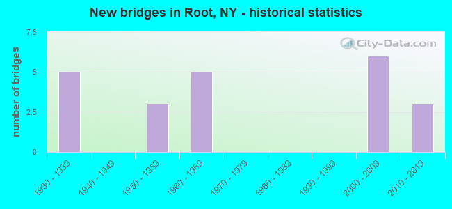
- New bridges - historical statistics
- 51930-1939
- 31950-1959
- 51960-1969
- 62000-2009
- 32010-2019

- Reconstructed bridges - Historical Statistics
- 11960-1969
- 11970-1979
- 21980-1989
- 01990-1999
- 12000-2009
- 12010-2019


- Bridge Condition - Deck
- 5.9%Excellent
- 29.4%Very good
- 11.8%Good
- 29.4%Satisfactory
- 17.6%Fair
- 5.9%Poor

- Bridge Condition - Superstructure
- 29.4%Excellent
- 23.5%Very good
- 11.8%Good
- 29.4%Satisfactory
- 5.9%Poor

- Bridge Condition - Substructure
- 29.4%Excellent
- 23.5%Very good
- 11.8%Good
- 11.8%Satisfactory
- 23.5%Fair

- Bridge Condition - Channel
- 22.2%Very good
- 16.7%Good
- 38.9%Satisfactory
- 5.6%Fair
- 16.7%Poor

- Bridge Condition - Culverts
- 66.7%Good
- 33.3%Fair
Find on map >> Show street view
Structure Number: 100284, Location: JCT RTS 162+5S (Lat: 42.891558, Lng: -74.519917), Route carried "on" structure: State highway 162, Year Built: 1969, Year Reconstructed: 2015, Status: Open, Structure Length: 5.82m (19.09ft), Average Daily Traffic: 1,509 (year 2018), Truck Traffic: 11%, Average Future Daily Traffic: 1,574 (year 2040), Design Load: HS 20, Features Intersected: RTE 5S
Minimum Vertical Clearance: 30+ m (98+ ft), Kilometerpoint: 18.359, Lanes on structure: 1, Lanes under structure: 1, Base Highway Network: Yes, Owner: State Highway Agency, Approaching Roadway Width: 4.3m (14.1ft), Skew: 5 degrees, Material/Design: Steel, Design/Construction: Stringer/Multi-beam, Number Of Spans In Main Unit: 3, Length of Maximum Span: 23.1m (75.8ft), Curb-To-Curb Width: 7.0m (23.0ft), Out-to-Out Width: 8.5m (27.9ft)
Condition: Deck: Fair, Superstructure: Satisfactory, Substructure: Good, Operating Rating: 68.9 metric tons, Method Used To Determine Operating Rating: Load Factor (LF), Inventory Rating: 40.8 metric tons, Method Used To Determine Inventory Rating: Load Factor (LF), Structural Evaluation: Equal to present minimum criteria, Deck Geometry: High priority of corrective action, Underclear: High priority of corrective action, Approach Roadway Alignment: Equal to present desirable criteria, Length Of Structure Improvement: 5.82m (19.09ft), Designated Inspection Frequency: Every 24 months, Inspection Date: April 2020, Bridge Improvement Cost: $869,000, Roadway Improvement Cost: $509,000, Total Project Cost: $1,379,000 ( Estimate for 2021), Deck Structure Type: Concrete Cast-file-Place, Wearing Surface/Protective System: Wearing Surface: Monolithic Concrete
Find on map >> Show street view
Structure Number: 100285, Location: 0.2 MI E JCT RTS 5S & 162 (Lat: 42.891339, Lng: -74.513906), Route carried "on" structure: State highway 5S, Year Built: 2009, Status: Open, Structure Length: 2.90m (9.51ft), Average Daily Traffic: 1,706 (year 2020), Truck Traffic: 11%, Average Future Daily Traffic: 1,779 (year 2040), Design Load: HL 93, Features Intersected: FLAT CREEK
Minimum Vertical Clearance: 30+ m (98+ ft), Kilometerpoint: 22.606, Lanes on structure: 2, Base Highway Network: Yes, Owner: State Highway Agency, Approaching Roadway Width: 12.2m (40.0ft), Material/Design: Prestressed concrete, Design/Construction: Box Beam or Girders - Multiple, Number Of Spans In Main Unit: 1, Length of Maximum Span: 28.0m (91.9ft), Curb-To-Curb Width: 12.2m (40.0ft), Out-to-Out Width: 13.1m (43.0ft)
Condition: Deck: Very good, Superstructure: Excellent, Substructure: Very good, Channel: Good, Operating Rating: 72.3 metric tons, Method Used To Determine Operating Rating: Load and Resistance Factor Rating (LRFR) rating reported by rating factor(RF) method using HL-93 loadings, Inventory Rating: 55.7 metric tons, Method Used To Determine Inventory Rating: Load and Resistance Factor Rating (LRFR) rating reported by rating factor(RF) method using HL-93 loadings, Structural Evaluation: Equal to present desirable criteria, Deck Geometry: Better than present minimum criteria, Waterway Adequacy: Somewhat better than minimum adequacy, Approach Roadway Alignment: Equal to present desirable criteria, Length Of Structure Improvement: 2.89m (9.48ft), Designated Inspection Frequency: Every 24 months, Inspection Date: April 2021, Bridge Improvement Cost: $1,007,000, Roadway Improvement Cost: $590,000, Total Project Cost: $1,597,000 ( Estimate for 2021), Wearing Surface/Protective System: Wearing Surface: Bituminous
Find on map >> Show street view
Structure Number: 100286, Location: 1.6 MI E JCT RTS 5S & 162 (Lat: 42.895217, Lng: -74.470761), Route carried "on" structure: State highway 5S, Year Built: 1931, Status: Open, Structure Length: 2.53m (8.30ft), Average Daily Traffic: 1,706 (year 2020), Truck Traffic: 11%, Average Future Daily Traffic: 1,779 (year 2040), Design Load: HS 20, Features Intersected: LASHERS CREEK
Minimum Vertical Clearance: 30+ m (98+ ft), Kilometerpoint: 26.211, Lanes on structure: 2, Base Highway Network: Yes, Owner: State Highway Agency, Approaching Roadway Width: 7.3m (24.0ft), Material/Design: Concrete, Design/Construction: Slab, Number Of Spans In Main Unit: 3, Length of Maximum Span: 6.7m (22.0ft), Curb-To-Curb Width: 7.3m (24.0ft), Out-to-Out Width: 8.7m (28.5ft)
Condition: Deck: Poor, Superstructure: Poor, Substructure: Fair, Channel: Poor, Operating Rating: 59.0 metric tons, Method Used To Determine Operating Rating: Load Factor (LF), Inventory Rating: 35.4 metric tons, Method Used To Determine Inventory Rating: Load Factor (LF), Structural Evaluation: Meets minimum limits, Deck Geometry: Meets minimum limits, Waterway Adequacy: High priority of corrective action, Approach Roadway Alignment: Equal to present desirable criteria, Length Of Structure Improvement: 2.52m (8.27ft), Designated Inspection Frequency: Every 24 months, Inspection Date: April 2020, Bridge Improvement Cost: $452,000, Roadway Improvement Cost: $265,000, Total Project Cost: $717,000 ( Estimate for 2021), Wearing Surface/Protective System: Wearing Surface: Bituminous
Find on map >> Show street view
Structure Number: 100287, Location: 34MI E JCT RTS 162+5S (Lat: 42.906561, Lng: -74.456561), Route carried "on" structure: State highway 5S, Year Built: 1954, Status: Open, Structure Length: 1.52m (4.99ft), Average Daily Traffic: 1,706 (year 2020), Truck Traffic: 11%, Average Future Daily Traffic: 1,779 (year 2040), Design Load: H 20, Features Intersected: YATESVILLE CREEK
Minimum Vertical Clearance: 30+ m (98+ ft), Kilometerpoint: 28.093, Lanes on structure: 2, Base Highway Network: Yes, Owner: State Highway Agency, Approaching Roadway Width: 8.8m (28.9ft), Material/Design: Concrete, Design/Construction: Culvert, Number Of Spans In Main Unit: 2, Length of Maximum Span: 7.0m (23.0ft), Curb-To-Curb Width: 10.6m (34.8ft), Out-to-Out Width: 11.4m (37.4ft)
Condition: Channel: Good, Culverts: Fair, Operating Rating: 48.3 metric tons, Method Used To Determine Operating Rating: Load and Resistance Factor Rating (LRFR) rating reported by rating factor(RF) method using HL-93 loadings, Inventory Rating: 37.3 metric tons, Method Used To Determine Inventory Rating: Load and Resistance Factor Rating (LRFR) rating reported by rating factor(RF) method using HL-93 loadings, Structural Evaluation: Somewhat better than minimum adequacy, Deck Geometry: Equal to present minimum criteria, Waterway Adequacy: Meets minimum limits, Approach Roadway Alignment: Equal to present desirable criteria, Length Of Structure Improvement: 1.52m (4.99ft), Designated Inspection Frequency: Every 24 months, Inspection Date: March 2020, Bridge Improvement Cost: $249,000, Roadway Improvement Cost: $146,000, Total Project Cost: $396,000 ( Estimate for 2021), Wearing Surface/Protective System: Wearing Surface: Bituminous
Find on map >> Show street view
Structure Number: 105186, Location: 05MI S JCT RTS 5S+162 (Lat: 42.889422, Lng: -74.515983), Route carried "on" structure: State highway 162, Year Built: 1969, Status: Open, Structure Length: 14.20m (46.59ft), Average Daily Traffic: 1,509 (year 2018), Truck Traffic: 11%, Average Future Daily Traffic: 1,574 (year 2040), Design Load: H 20, Features Intersected: FLATT CREEK, CANYON ROAD
Minimum Vertical Clearance: 30+ m (98+ ft), Kilometerpoint: 17.860, Lanes on structure: 3, Lanes under structure: 1, Base Highway Network: Yes, Owner: State Highway Agency, Approaching Roadway Width: 7.3m (24.0ft), Material/Design: Steel continuous, Design/Construction: Stringer/Multi-beam, Number Of Spans In Main Unit: 3, Length of Maximum Span: 54.8m (179.8ft), Curb-To-Curb Width: 11.9m (39.0ft), Out-to-Out Width: 12.7m (41.7ft)
Condition: Deck: Satisfactory, Superstructure: Satisfactory, Substructure: Good, Channel: Very good, Operating Rating: 54.4 metric tons, Method Used To Determine Operating Rating: Load Factor (LF), Inventory Rating: 34.5 metric tons, Method Used To Determine Inventory Rating: Load Factor (LF), Structural Evaluation: Equal to present minimum criteria, Deck Geometry: High priority of corrective action, Underclear: High priority of corrective action, Waterway Adequacy: Equal to present desirable criteria, Approach Roadway Alignment: Equal to present desirable criteria, Length Of Structure Improvement: 14.20m (46.59ft), Designated Inspection Frequency: Every 24 months, Inspection Date: August 2020, Bridge Improvement Cost: $2,895,000, Roadway Improvement Cost: $1,695,000, Total Project Cost: $4,590,000 ( Estimate for 2021), Deck Structure Type: Concrete Cast-file-Place, Wearing Surface/Protective System: Wearing Surface: Monolithic Concrete
Find on map >> Show street view
Structure Number: 105187, Location: .2 MI S JCT SH 5S & SH16 (Lat: 42.890489, Lng: -74.518042), Route carried "on" structure: State highway 162, Year Built: 1969, Year Reconstructed: 2013, Status: Open, Structure Length: 2.56m (8.40ft), Average Daily Traffic: 1,509 (year 2018), Truck Traffic: 11%, Average Future Daily Traffic: 1,574 (year 2040), Design Load: HS 20, Features Intersected: EX-NY WS & BUF RR
Minimum Vertical Clearance: 30+ m (98+ ft), Kilometerpoint: 18.166, Lanes on structure: 2, Base Highway Network: Yes, Owner: State Highway Agency, Approaching Roadway Width: 10.7m (35.1ft), Skew: 6 degrees, Material/Design: Steel, Design/Construction: Stringer/Multi-beam, Number Of Spans In Main Unit: 1, Length of Maximum Span: 22.8m (74.8ft), Curb-To-Curb Width: 10.8m (35.4ft), Out-to-Out Width: 11.9m (39.0ft)
Condition: Deck: Very good, Superstructure: Very good, Substructure: Satisfactory, Operating Rating: 80.7 metric tons, Method Used To Determine Operating Rating: Load Factor (LF), Inventory Rating: 48.1 metric tons, Method Used To Determine Inventory Rating: Load Factor (LF), Structural Evaluation: Equal to present minimum criteria, Deck Geometry: Equal to present minimum criteria, Approach Roadway Alignment: Equal to present desirable criteria, Length Of Structure Improvement: 2.56m (8.40ft), Designated Inspection Frequency: Every 24 months, Inspection Date: November 2021, Bridge Improvement Cost: $2,003,000, Roadway Improvement Cost: $1,173,000, Total Project Cost: $3,176,000 ( Estimate for 2021), Deck Structure Type: Concrete Cast-file-Place, Wearing Surface/Protective System: Wearing Surface: Integral Concrete
Find on map >> Show street view
Structure Number: 330984, Location: 4.8 MI SE OF AMES (Lat: 42.802847, Lng: -74.524133), Route carried "on" structure: Other road , Year Built: 2004, Status: Open, Structure Length: 1.80m (5.91ft), Average Daily Traffic: 144 (year 2020), Truck Traffic: 1%, Average Future Daily Traffic: 202 (year 2040), Features Intersected: FLAT CREEK, Facility Carried by Structure: MELICK ROAD
Minimum Vertical Clearance: 30+ m (98+ ft), Kilometerpoint: 2.269, Lanes on structure: 2, Owner: County Highway Agency, Approaching Roadway Width: 5.8m (19.0ft), Skew: 1 degrees, Material/Design: Prestressed concrete, Design/Construction: Box Beam or Girders - Multiple, Number Of Spans In Main Unit: 1, Length of Maximum Span: 14.3m (46.9ft), Curb-To-Curb Width: 9.1m (29.9ft), Out-to-Out Width: 10.1m (33.1ft)
Condition: Deck: Good, Superstructure: Good, Substructure: Very good, Channel: Satisfactory, Operating Rating: 68.9 metric tons, Method Used To Determine Operating Rating: Load Factor (LF), Inventory Rating: 41.7 metric tons, Method Used To Determine Inventory Rating: Load Factor (LF), Structural Evaluation: Better than present minimum criteria, Deck Geometry: Equal to present minimum criteria, Waterway Adequacy: Equal to present minimum criteria, Approach Roadway Alignment: Equal to present desirable criteria, Length Of Structure Improvement: 1.79m (5.87ft), Designated Inspection Frequency: Every 24 months, Inspection Date: October 2020, Bridge Improvement Cost: $367,000, Roadway Improvement Cost: $215,000, Total Project Cost: $582,000 ( Estimate for 2021), Deck Structure Type: Concrete Cast-file-Place, Wearing Surface/Protective System: Wearing Surface: Monolithic Concrete
Find on map >> Show street view
Structure Number: 330985, Location: 2.8 MI S OF SPRAKERS (Lat: 42.852186, Lng: -74.523733), Route carried "on" structure: County highway , Year Built: 2005, Status: Open, Structure Length: 2.16m (7.09ft), Average Daily Traffic: 119 (year 2019), Truck Traffic: 4%, Average Future Daily Traffic: 167 (year 2039), Design Load: HS 25 or greater, Features Intersected: FLAT CREEK, Facility Carried by Structure: CR96 HILLTOP ROAD
Minimum Vertical Clearance: 30+ m (98+ ft), Kilometerpoint: 0.306, Lanes on structure: 2, Owner: County Highway Agency, Approaching Roadway Width: 4.9m (16.1ft), Material/Design: Prestressed concrete, Design/Construction: Box Beam or Girders - Multiple, Number Of Spans In Main Unit: 1, Length of Maximum Span: 20.4m (66.9ft), Curb-To-Curb Width: 9.2m (30.2ft), Out-to-Out Width: 10.2m (33.5ft)
Condition: Deck: Satisfactory, Superstructure: Very good, Substructure: Very good, Channel: Satisfactory, Operating Rating: 89.7 metric tons, Method Used To Determine Operating Rating: Load and Resistance Factor Rating (LRFR) rating reported by rating factor(RF) method using HL-93 loadings, Inventory Rating: 69.3 metric tons, Method Used To Determine Inventory Rating: Load and Resistance Factor Rating (LRFR) rating reported by rating factor(RF) method using HL-93 loadings, Structural Evaluation: Equal to present desirable criteria, Deck Geometry: Equal to present minimum criteria, Waterway Adequacy: Somewhat better than minimum adequacy, Approach Roadway Alignment: Equal to present desirable criteria, Length Of Structure Improvement: 2.16m (7.09ft), Designated Inspection Frequency: Every 24 months, Inspection Date: September 2021, Bridge Improvement Cost: $814,000, Roadway Improvement Cost: $477,000, Total Project Cost: $1,291,000 ( Estimate for 2021), Deck Structure Type: Concrete Cast-file-Place, Wearing Surface/Protective System: Wearing Surface: Integral Concrete, Deck Protection: Epoxy Coated Reinforcing
Find on map >> Show street view
Structure Number: 330986, Location: SPRAKERS (Lat: 42.890619, Lng: -74.514350), Route carried "on" structure: County highway , Year Built: 1939, Year Reconstructed: 1966, Status: Posted for load, Structure Length: 2.35m (7.71ft), Average Daily Traffic: 62 (year 2017), Truck Traffic: 4%, Average Future Daily Traffic: 87 (year 2037), Features Intersected: FLAT CREEK, Facility Carried by Structure: CR107 SPRAKERS ROA
Minimum Vertical Clearance: 30+ m (98+ ft), Kilometerpoint: 0.048, Lanes on structure: 2, Owner: County Highway Agency, Approaching Roadway Width: 5.5m (18.0ft), Skew: 2 degrees, Material/Design: Steel, Design/Construction: Stringer/Multi-beam, Number Of Spans In Main Unit: 1, Length of Maximum Span: 21.9m (71.9ft), Curb or Sidewalk Widths: Left: 1.1m (3.6ft), Right: 0.3m (1.0ft), Curb-To-Curb Width: 6.2m (20.3ft), Out-to-Out Width: 8.4m (27.6ft)
Condition: Deck: Satisfactory, Superstructure: Satisfactory, Substructure: Satisfactory, Channel: Satisfactory, Operating Rating: 15.2 metric tons, Method Used To Determine Operating Rating: Load and Resistance Factor Rating (LRFR) rating reported by rating factor(RF) method using HL-93 loadings, Inventory Rating: 11.7 metric tons, Method Used To Determine Inventory Rating: Load and Resistance Factor Rating (LRFR) rating reported by rating factor(RF) method using HL-93 loadings, Structural Evaluation: Meets minimum limits, Deck Geometry: Somewhat better than minimum adequacy, Waterway Adequacy: Meets minimum limits, Approach Roadway Alignment: Somewhat better than minimum adequacy, Bridge Posting: Required (Relationship of Operating Rating to Maximum Legal Load: > 39.9% below), Length Of Structure Improvement: 2.34m (7.68ft), Designated Inspection Frequency: Every 12 months, Inspection Date: June 2021, Bridge Improvement Cost: $587,000, Roadway Improvement Cost: $343,000, Total Project Cost: $930,000 ( Estimate for 2021), Deck Structure Type: Concrete Cast-file-Place, Wearing Surface/Protective System: Wearing Surface: Bituminous
Find on map >> Show street view
Structure Number: 330987, Location: 3.2 MILES S OF SPRAKERS (Lat: 42.848219, Lng: -74.513278), Route carried "on" structure: Other road , Year Built: 1937, Status: Open, Structure Length: 1.80m (5.91ft), Average Daily Traffic: 94 (year 2017), Truck Traffic: 5%, Average Future Daily Traffic: 132 (year 2037), Features Intersected: FLAT CREEK, Facility Carried by Structure: RAPPA ROAD
Minimum Vertical Clearance: 30+ m (98+ ft), Kilometerpoint: 0.225, Lanes on structure: 2, Owner: County Highway Agency, Approaching Roadway Width: 5.5m (18.0ft), Skew: 3 degrees, Material/Design: Steel, Design/Construction: Stringer/Multi-beam, Number Of Spans In Main Unit: 1, Length of Maximum Span: 17.3m (56.8ft), Curb-To-Curb Width: 6.1m (20.0ft), Out-to-Out Width: 7.2m (23.6ft)
Condition: Deck: Fair, Superstructure: Satisfactory, Substructure: Fair, Channel: Poor, Operating Rating: 55.7 metric tons, Method Used To Determine Operating Rating: Field evaluation and documented engineering judgment, Inventory Rating: 22.3 metric tons, Method Used To Determine Inventory Rating: Field evaluation and documented engineering judgment, Structural Evaluation: Somewhat better than minimum adequacy, Deck Geometry: Somewhat better than minimum adequacy, Waterway Adequacy: Meets minimum limits, Approach Roadway Alignment: Meets minimum limits, Length Of Structure Improvement: 1.79m (5.87ft), Designated Inspection Frequency: Every 24 months, Inspection Date: June 2021, Bridge Improvement Cost: $406,000, Roadway Improvement Cost: $238,000, Total Project Cost: $644,000 ( Estimate for 2021), Deck Structure Type: Concrete Cast-file-Place, Wearing Surface/Protective System: Wearing Surface: Bituminous
Find on map >> Show street view
Structure Number: 330989, Location: 5.3 MI E OF AMES (Lat: 42.807358, Lng: -74.506289), Route carried "on" structure: County highway , Year Built: 2006, Status: Open, Structure Length: 2.53m (8.30ft), Average Daily Traffic: 183 (year 2016), Truck Traffic: 8%, Average Future Daily Traffic: 256 (year 2036), Design Load: HS 25 or greater, Features Intersected: FLAT CREEK, Facility Carried by Structure: LATIMER HILL ROAD
Minimum Vertical Clearance: 30+ m (98+ ft), Kilometerpoint: 8.463, Lanes on structure: 2, Owner: County Highway Agency, Approaching Roadway Width: 8.5m (27.9ft), Skew: 4 degrees, Material/Design: Steel, Design/Construction: Stringer/Multi-beam, Number Of Spans In Main Unit: 1, Length of Maximum Span: 24.5m (80.4ft), Curb-To-Curb Width: 8.4m (27.6ft), Out-to-Out Width: 9.4m (30.8ft)
Condition: Deck: Satisfactory, Superstructure: Excellent, Substructure: Excellent, Channel: Satisfactory, Inventory Rating: 68.0 metric tons, Method Used To Determine Inventory Rating: Load Factor (LF), Structural Evaluation: Superior to present desirable criteria, Deck Geometry: Somewhat better than minimum adequacy, Waterway Adequacy: Somewhat better than minimum adequacy, Approach Roadway Alignment: Equal to present minimum criteria, Length Of Structure Improvement: 2.52m (8.27ft), Designated Inspection Frequency: Every 24 months, Inspection Date: October 2020, Bridge Improvement Cost: $471,000, Roadway Improvement Cost: $276,000, Total Project Cost: $746,000 ( Estimate for 2021), Deck Structure Type: Concrete Cast-file-Place, Wearing Surface/Protective System: Wearing Surface: Integral Concrete, Deck Protection: Epoxy Coated Reinforcing
Find on map >> Show street view
Structure Number: 33099, Location: 3.5 MI S OF SPRAKERS (Lat: 42.844194, Lng: -74.500464), Route carried "on" structure: County highway , Year Built: 2002, Status: Open, Structure Length: 1.86m (6.10ft), Average Daily Traffic: 300 (year 2017), Truck Traffic: 4%, Average Future Daily Traffic: 420 (year 2037), Design Load: HS 25 or greater, Features Intersected: FLAT CREEK, Facility Carried by Structure: CR98 FLAT CREEK RD
Minimum Vertical Clearance: 30+ m (98+ ft), Kilometerpoint: 0.209, Lanes on structure: 2, Owner: County Highway Agency, Approaching Roadway Width: 8.8m (28.9ft), Material/Design: Prestressed concrete, Design/Construction: Box Beam or Girders - Multiple, Number Of Spans In Main Unit: 1, Length of Maximum Span: 18.0m (59.1ft), Curb-To-Curb Width: 8.9m (29.2ft), Out-to-Out Width: 9.9m (32.5ft)
Condition: Deck: Very good, Superstructure: Very good, Substructure: Excellent, Channel: Good, Operating Rating: 64.8 metric tons, Method Used To Determine Operating Rating: Load and Resistance Factor Rating (LRFR) rating reported by rating factor(RF) method using HL-93 loadings, Inventory Rating: 49.9 metric tons, Method Used To Determine Inventory Rating: Load and Resistance Factor Rating (LRFR) rating reported by rating factor(RF) method using HL-93 loadings, Structural Evaluation: Equal to present desirable criteria, Deck Geometry: Equal to present minimum criteria, Waterway Adequacy: Somewhat better than minimum adequacy, Approach Roadway Alignment: Somewhat better than minimum adequacy, Length Of Structure Improvement: 1.85m (6.07ft), Designated Inspection Frequency: Every 24 months, Inspection Date: May 2021, Bridge Improvement Cost: $641,000, Roadway Improvement Cost: $376,000, Total Project Cost: $1,017,000 ( Estimate for 2021), Wearing Surface/Protective System: Wearing Surface: Bituminous, Membrane: Other
Find on map >> Show street view
Structure Number: 330991, Location: 5.5 MI EAST OF AMES (Lat: 42.835303, Lng: -74.497039), Route carried "on" structure: County highway , Year Built: 2002, Status: Open, Structure Length: 1.52m (4.99ft), Average Daily Traffic: 313 (year 2017), Truck Traffic: 2%, Average Future Daily Traffic: 438 (year 2037), Design Load: HS 25 or greater, Features Intersected: FLAT CREEK, Facility Carried by Structure: CR93 CARLISLE ROAD
Minimum Vertical Clearance: 30+ m (98+ ft), Kilometerpoint: 10.008, Lanes on structure: 2, Owner: County Highway Agency, Approaching Roadway Width: 7.3m (24.0ft), Skew: 1 degrees, Material/Design: Prestressed concrete, Design/Construction: Box Beam or Girders - Multiple, Number Of Spans In Main Unit: 1, Length of Maximum Span: 14.1m (46.3ft), Curb-To-Curb Width: 7.2m (23.6ft), Out-to-Out Width: 8.2m (26.9ft)
Condition: Deck: Good, Superstructure: Excellent, Substructure: Very good, Channel: Satisfactory, Operating Rating: 55.1 metric tons, Method Used To Determine Operating Rating: Load and Resistance Factor Rating (LRFR) rating reported by rating factor(RF) method using HL-93 loadings, Inventory Rating: 42.4 metric tons, Method Used To Determine Inventory Rating: Load and Resistance Factor Rating (LRFR) rating reported by rating factor(RF) method using HL-93 loadings, Structural Evaluation: Equal to present desirable criteria, Deck Geometry: Meets minimum limits, Waterway Adequacy: Meets minimum limits, Approach Roadway Alignment: Equal to present desirable criteria, Length Of Structure Improvement: 1.52m (4.99ft), Designated Inspection Frequency: Every 24 months, Inspection Date: April 2021, Bridge Improvement Cost: $379,000, Roadway Improvement Cost: $222,000, Total Project Cost: $602,000 ( Estimate for 2021), Deck Structure Type: Concrete Cast-file-Place, Wearing Surface/Protective System: Wearing Surface: Integral Concrete, Deck Protection: Epoxy Coated Reinforcing
Find on map >> Show street view
Structure Number: 330992, Location: 1.0 MI NW OF LYKERS (Lat: 42.825678, Lng: -74.474819), Route carried "on" structure: Other road , Year Built: 1934, Year Reconstructed: 1979, Status: Open, Structure Length: 1.34m (4.40ft), Average Daily Traffic: 242 (year 2019), Truck Traffic: 3%, Average Future Daily Traffic: 339 (year 2039), Features Intersected: EAST CREEK, Facility Carried by Structure: DARROW ROAD
Minimum Vertical Clearance: 30+ m (98+ ft), Kilometerpoint: 1.223, Lanes on structure: 2, Owner: County Highway Agency, Approaching Roadway Width: 6.1m (20.0ft), Material/Design: Steel, Design/Construction: Stringer/Multi-beam, Number Of Spans In Main Unit: 1, Length of Maximum Span: 12.8m (42.0ft), Curb-To-Curb Width: 7.9m (25.9ft), Out-to-Out Width: 9.2m (30.2ft)
Condition: Deck: Fair, Superstructure: Satisfactory, Substructure: Fair, Channel: Fair, Operating Rating: 59.1 metric tons, Method Used To Determine Operating Rating: Field evaluation and documented engineering judgment, Inventory Rating: 24.6 metric tons, Method Used To Determine Inventory Rating: Field evaluation and documented engineering judgment, Structural Evaluation: Somewhat better than minimum adequacy, Deck Geometry: Somewhat better than minimum adequacy, Waterway Adequacy: Meets minimum limits, Approach Roadway Alignment: Meets minimum limits, Length Of Structure Improvement: 1.34m (4.40ft), Designated Inspection Frequency: Every 24 months, Inspection Date: July 2021, Bridge Improvement Cost: $427,000, Roadway Improvement Cost: $250,000, Total Project Cost: $676,000 ( Estimate for 2021), Deck Structure Type: Concrete Cast-file-Place, Wearing Surface/Protective System: Wearing Surface: Bituminous
Find on map >> Show street view
Structure Number: 330993, Location: 6.5 MI E OF CANAJOHARIE (Lat: 42.906333, Lng: -74.454128), Route carried "on" structure: County highway , Year Built: 1935, Status: Open, Structure Length: 1.52m (4.99ft), Average Daily Traffic: 313 (year 2018), Truck Traffic: 7%, Average Future Daily Traffic: 438 (year 2038), Features Intersected: YATESVILLE CREEK, Facility Carried by Structure: CR105 CURRYTOWN RD
Minimum Vertical Clearance: 30+ m (98+ ft), Kilometerpoint: 5.567, Lanes on structure: 2, Owner: County Highway Agency, Approaching Roadway Width: 4.9m (16.1ft), Skew: 4 degrees, Material/Design: Steel, Design/Construction: Stringer/Multi-beam, Number Of Spans In Main Unit: 1, Length of Maximum Span: 14.0m (45.9ft), Curb-To-Curb Width: 6.1m (20.0ft), Out-to-Out Width: 7.2m (23.6ft)
Condition: Deck: Satisfactory, Superstructure: Good, Substructure: Fair, Channel: Poor, Operating Rating: 39.9 metric tons, Method Used To Determine Operating Rating: Load Factor (LF), Inventory Rating: 23.6 metric tons, Method Used To Determine Inventory Rating: Load Factor (LF), Structural Evaluation: Somewhat better than minimum adequacy, Deck Geometry: Meets minimum limits, Waterway Adequacy: Meets minimum limits, Approach Roadway Alignment: Somewhat better than minimum adequacy, Length Of Structure Improvement: 1.52m (4.99ft), Designated Inspection Frequency: Every 24 months, Inspection Date: May 2021, Bridge Improvement Cost: $283,000, Roadway Improvement Cost: $165,000, Total Project Cost: $448,000 ( Estimate for 2021), Deck Structure Type: Concrete Cast-file-Place, Wearing Surface/Protective System: Wearing Surface: Bituminous
Find on map >> Show street view
Structure Number: 330994, Location: 4.5 MI S OF RANDALL (Lat: 42.848153, Lng: -74.440897), Route carried "on" structure: County highway , Year Built: 2014, Status: Open, Structure Length: 1.25m (4.10ft), Average Daily Traffic: 284 (year 2020), Truck Traffic: 8%, Average Future Daily Traffic: 398 (year 2040), Design Load: HL 93, Features Intersected: YATESVILLE CREEK, Facility Carried by Structure: LOGTOWN ROAD
Minimum Vertical Clearance: 30+ m (98+ ft), Kilometerpoint: 0.032, Lanes on structure: 2, Owner: County Highway Agency, Approaching Roadway Width: 7.3m (24.0ft), Material/Design: Concrete, Design/Construction: Frame, Number Of Spans In Main Unit: 1, Length of Maximum Span: 12.2m (40.0ft), Curb-To-Curb Width: 9.1m (29.9ft), Out-to-Out Width: 10.1m (33.1ft)
Condition: Deck: Very good, Superstructure: Very good, Substructure: Excellent, Channel: Very good, Operating Rating: 48.0 metric tons, Method Used To Determine Operating Rating: Load and Resistance Factor Rating (LRFR) rating reported by rating factor(RF) method using HL-93 loadings, Inventory Rating: 36.9 metric tons, Method Used To Determine Inventory Rating: Load and Resistance Factor Rating (LRFR) rating reported by rating factor(RF) method using HL-93 loadings, Structural Evaluation: Equal to present desirable criteria, Deck Geometry: Equal to present minimum criteria, Waterway Adequacy: Equal to present desirable criteria, Approach Roadway Alignment: Better than present minimum criteria, Length Of Structure Improvement: 1.24m (4.07ft), Designated Inspection Frequency: Every 24 months, Inspection Date: September 2020, Bridge Improvement Cost: $392,000, Roadway Improvement Cost: $229,000, Total Project Cost: $621,000 ( Estimate for 2021), Wearing Surface/Protective System: Wearing Surface: Bituminous
Find on map >> Show street view
Structure Number: 330995, Location: 4.6 MILES S OF RANDALL (Lat: 42.847708, Lng: -74.437914), Route carried "on" structure: County highway , Year Built: 2014, Status: Open, Structure Length: 2.26m (7.41ft), Average Daily Traffic: 152 (year 2017), Truck Traffic: 5%, Average Future Daily Traffic: 213 (year 2037), Design Load: HL 93, Features Intersected: YATESVILLE CREEK, Facility Carried by Structure: COUNTY ROAD 130
Minimum Vertical Clearance: 30+ m (98+ ft), Kilometerpoint: 0.225, Lanes on structure: 2, Owner: County Highway Agency, Approaching Roadway Width: 9.1m (29.9ft), Skew: 4 degrees, Material/Design: Prestressed concrete, Design/Construction: Box Beam or Girders - Multiple, Number Of Spans In Main Unit: 1, Length of Maximum Span: 21.0m (68.9ft), Curb-To-Curb Width: 9.1m (29.9ft), Out-to-Out Width: 10.1m (33.1ft)
Condition: Deck: Excellent, Superstructure: Excellent, Substructure: Excellent, Channel: Very good, Operating Rating: 80.7 metric tons, Method Used To Determine Operating Rating: Load and Resistance Factor Rating (LRFR) rating reported by rating factor(RF) method using HL-93 loadings, Inventory Rating: 62.2 metric tons, Method Used To Determine Inventory Rating: Load and Resistance Factor Rating (LRFR) rating reported by rating factor(RF) method using HL-93 loadings, Structural Evaluation: Superior to present desirable criteria, Deck Geometry: Equal to present minimum criteria, Waterway Adequacy: Equal to present minimum criteria, Approach Roadway Alignment: Somewhat better than minimum adequacy, Length Of Structure Improvement: 2.25m (7.38ft), Designated Inspection Frequency: Every 24 months, Inspection Date: September 2020, Bridge Improvement Cost: $529,000, Roadway Improvement Cost: $310,000, Total Project Cost: $839,000 ( Estimate for 2021), Deck Structure Type: Concrete Cast-file-Place, Wearing Surface/Protective System: Wearing Surface: Monolithic Concrete, Deck Protection: Epoxy Coated Reinforcing
Find on map >> Show street view
Structure Number: 551591, Location: 0.5 MI S YOSTS (Lat: 42.906703, Lng: -74.456833), Route carried "on" structure: Interstate 90, Year Built: 1955, Year Reconstructed: 1992, Status: Open, Structure Length: 1.52m (4.99ft), Average Daily Traffic: 19,439 (year 2020), Truck Traffic: 32%, Average Future Daily Traffic: 21,621 (year 2040), Design Load: HS 20+Mod, Features Intersected: YATESVILLE CREEK
Minimum Vertical Clearance: 30+ m (98+ ft), Kilometerpoint: 29.364, Lanes on structure: 4, Base Highway Network: Yes, Toll: On Interstate toll segment, Owner: State Toll Authority, Approaching Roadway Width: 25.0m (82.0ft), Skew: 30 degrees, Material/Design: Concrete, Design/Construction: Culvert, Number Of Spans In Main Unit: 2, Length of Maximum Span: 7.0m (23.0ft), Curb-To-Curb Width: 34.4m (112.9ft), Out-to-Out Width: 38.0m (124.7ft)
Condition: Channel: Satisfactory, Culverts: Good, Operating Rating: 74.4 metric tons, Method Used To Determine Operating Rating: Load Factor (LF), Inventory Rating: 44.5 metric tons, Method Used To Determine Inventory Rating: Load Factor (LF), Structural Evaluation: Better than present minimum criteria, Deck Geometry: Superior to present desirable criteria, Waterway Adequacy: Superior to present desirable criteria, Approach Roadway Alignment: Equal to present desirable criteria, Length Of Structure Improvement: 1.52m (4.99ft), Designated Inspection Frequency: Every 24 months, Inspection Date: April 2021, Bridge Improvement Cost: $1,302,000, Roadway Improvement Cost: $762,000, Total Project Cost: $2,064,000 ( Estimate for 2021)
Find on map >> Show street view
Structure Number: 551592, Location: 1.3 MI SE OF YOSTS (Lat: 42.895817, Lng: -74.470853), Route carried "on" structure: Interstate 90, Year Built: 1955, Year Reconstructed: 1992, Status: Open, Structure Length: 1.16m (3.81ft), Average Daily Traffic: 19,439 (year 2020), Truck Traffic: 32%, Average Future Daily Traffic: 21,621 (year 2040), Design Load: HS 20+Mod, Features Intersected: LASHERS CREEK
Minimum Vertical Clearance: 30+ m (98+ ft), Kilometerpoint: 27.610, Lanes on structure: 4, Base Highway Network: Yes, Toll: On Interstate toll segment, Owner: State Toll Authority, Approaching Roadway Width: 34.1m (111.9ft), Skew: 30 degrees, Material/Design: Concrete, Design/Construction: Culvert, Number Of Spans In Main Unit: 2, Length of Maximum Span: 5.2m (17.1ft), Curb-To-Curb Width: 34.6m (113.5ft), Out-to-Out Width: 39.9m (130.9ft)
Condition: Channel: Satisfactory, Culverts: Good, Operating Rating: 35.4 metric tons, Method Used To Determine Operating Rating: Load Factor (LF), Inventory Rating: 20.9 metric tons, Method Used To Determine Inventory Rating: Load Factor (LF), Structural Evaluation: Somewhat better than minimum adequacy, Deck Geometry: Superior to present desirable criteria, Waterway Adequacy: Meets minimum limits, Approach Roadway Alignment: Equal to present desirable criteria, Length Of Structure Improvement: 1.15m (3.77ft), Designated Inspection Frequency: Every 24 months, Inspection Date: March 2021, Bridge Improvement Cost: $1,943,000, Roadway Improvement Cost: $1,138,000, Total Project Cost: $3,081,000 ( Estimate for 2021)
Find on map >> Show street view
Structure Number: 5515939, Location: AT SPRAKERS (Lat: 42.893408, Lng: -74.513342), Route carried "on" structure: Interstate 90, Year Built: 2019, Status: Open, Structure Length: 5.12m (16.80ft), Average Daily Traffic: 19,439 (year 2020), Truck Traffic: 32%, Average Future Daily Traffic: 21,621 (year 2040), Design Load: HL 93, Features Intersected: FLAT CREEK
Minimum Vertical Clearance: 30+ m (98+ ft), Kilometerpoint: 24.119, Lanes on structure: 4, Base Highway Network: Yes, Toll: On Interstate toll segment, Owner: State Toll Authority, Approaching Roadway Width: 34.1m (111.9ft), Skew: 21 degrees, Material/Design: Steel, Design/Construction: Stringer/Multi-beam, Number Of Spans In Main Unit: 1, Length of Maximum Span: 50.9m (167.0ft), Curb-To-Curb Width: 34.4m (112.9ft), Out-to-Out Width: 36.3m (119.1ft)
Condition: Deck: Very good, Superstructure: Excellent, Substructure: Excellent, Channel: Very good, Operating Rating: 99.8 metric tons, Method Used To Determine Operating Rating: Load Factor (LF), Inventory Rating: 59.9 metric tons, Method Used To Determine Inventory Rating: Load Factor (LF), Structural Evaluation: Superior to present desirable criteria, Deck Geometry: Superior to present desirable criteria, Waterway Adequacy: Meets minimum limits, Approach Roadway Alignment: Equal to present desirable criteria, Length Of Structure Improvement: 5.12m (16.80ft), Designated Inspection Frequency: Every 24 months, Inspection Date: October 2021, Bridge Improvement Cost: $3,255,000, Roadway Improvement Cost: $1,906,000, Total Project Cost: $5,161,000 ( Estimate for 2021), Deck Structure Type: Concrete Cast-file-Place, Wearing Surface/Protective System: Wearing Surface: Monolithic Concrete, Membrane: Other, Deck Protection: Galvanized Reinforcing
Find on map >> Show street view
Structure Number: 100284, Location: JCT RTS 162+5S (Lat: 42.891558, Lng: -74.519917), Route carried "under" structure: State highway 5S, Year Built: 1969, Structure Length: 0. m, Average Daily Traffic: 5,092 (year 2000), Features Intersected: RTE 5S, Facility Carried by Structure: RTE 162
Minimum Vertical Clearance: 4.45m (14.60ft), Kilometerpoint: 22.156, Lanes on structure: 1, Lanes under structure: 1, Material/Design: Steel, Design/Construction: Stringer/Multi-beam, Length of Maximum Span: 23.1m (75.8ft)
Find on map >> Show street view
Structure Number: 105186, Location: 05MI S JCT RTS 5S+162 (Lat: 42.889422, Lng: -74.515983), Route carried "under" structure: Other road , Year Built: 1969, Structure Length: 0. m, Average Daily Traffic: 100 (year 2021), Features Intersected: FLATT CREEK, CANYON ROAD, Facility Carried by Structure: RTE 162
Minimum Vertical Clearance: 10.06m (33.01ft), Kilometerpoint: 0.080, Lanes on structure: 3, Lanes under structure: 1, Material/Design: Steel continuous, Design/Construction: Stringer/Multi-beam, Length of Maximum Span: 54.8m (179.8ft)