Bridge Statistics for Rocklin, California (CA)
Condition, Traffic, Stress, Structural Evaluation, Project Costs
- National Bridge Inventory (NBI) Statistics
- 21Number of bridges
- 200ft / 61.0mTotal length
- 748,422Total average daily traffic
- 85,528Total average daily truck traffic
- National Bridge Inventory (NBI) Registered Bridges for Rocklin
- No street view available for this location
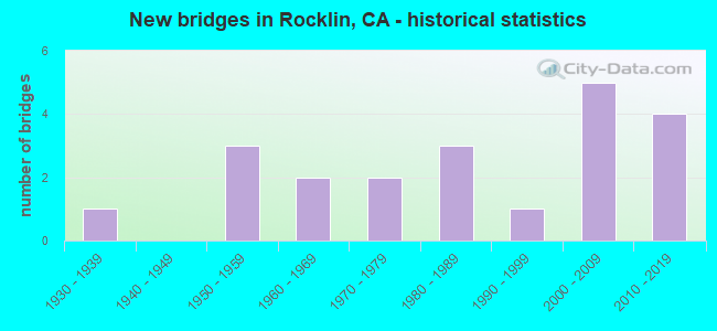
- New bridges - historical statistics
- 11930-1939
- 31950-1959
- 21960-1969
- 21970-1979
- 31980-1989
- 11990-1999
- 52000-2009
- 42010-2019


- Bridge Condition - Deck
- 58.3%Good
- 16.7%Satisfactory
- 25.0%Fair

- Bridge Condition - Superstructure
- 75.0%Good
- 16.7%Satisfactory
- 8.3%Fair

- Bridge Condition - Substructure
- 75.0%Good
- 16.7%Satisfactory
- 8.3%Fair

- Bridge Condition - Channel
- 33.3%Very good
- 16.7%Good
- 50.0%Satisfactory

- Bridge Condition - Culverts
- 50.0%Good
- 50.0%Satisfactory
Find on map >> Show street view
Structure Number: 19 009, Location: 03-PLA-080-34.99 (Lat: 39.121611, Lng: -120.940878), Route carried "on" structure: Interstate 80, Year Built: 1958, Status: Open, Structure Length: 2.80m (9.19ft), Average Daily Traffic: 29,000 (year 2004), Truck Traffic: 13%, Average Future Daily Traffic: 48,944 (year 2041), Design Load: HS 20, Features Intersected: CARPENTER ROAD
Minimum Vertical Clearance: 30+ m (98+ ft), Kilometerpoint: 34.990, Lanes on structure: 4, Lanes under structure: 1, Base Highway Network: Yes (, Subroute: 2), Owner: State Highway Agency, Approaching Roadway Width: 18.4m (60.4ft), Skew: 30 degrees, Material/Design: Concrete continuous, Design/Construction: Slab, Number Of Spans In Main Unit: 3, Length of Maximum Span: 11.0m (36.1ft), Curb-To-Curb Width: 18.4m (60.4ft), Out-to-Out Width: 19.9m (65.3ft)
Condition: Deck: Satisfactory, Superstructure: Satisfactory, Substructure: Good, Operating Rating: 75.8 metric tons, Method Used To Determine Operating Rating: Load Factor (LF), Inventory Rating: 45.7 metric tons, Method Used To Determine Inventory Rating: Load Factor (LF), Structural Evaluation: Equal to present minimum criteria, Deck Geometry: Meets minimum limits, Underclear: Meets minimum limits, Approach Roadway Alignment: Better than present minimum criteria, Designated Inspection Frequency: Every 24 months, Inspection Date: June 2021, Deck Structure Type: Concrete Cast-file-Place, Wearing Surface/Protective System: Wearing Surface: Integral Concrete
Find on map >> Show street view
Structure Number: 19 0094, Location: 03-PLA-080-6.06-ROC (Lat: 38.788436, Lng: -121.222522), Route carried "on" structure: Interstate 80, Year Built: 1959, Year Reconstructed: 1975, Status: Open, Structure Length: 2.90m (9.51ft), Average Daily Traffic: 92,000 (year 2009), Truck Traffic: 8%, Average Future Daily Traffic: 156,111 (year 2039), Design Load: HS 20, Features Intersected: ROCKLIN ROAD
Minimum Vertical Clearance: 30+ m (98+ ft), Kilometerpoint: 6.060, Lanes on structure: 6, Lanes under structure: 4, Base Highway Network: Yes (, Subroute: 2), Owner: State Highway Agency, Approaching Roadway Width: 34.1m (111.9ft), Skew: 34 degrees, Material/Design: Concrete, Design/Construction: Box Beam or Girders - Multiple, Number Of Spans In Main Unit: 1, Length of Maximum Span: 27.4m (89.9ft), Curb-To-Curb Width: 34.1m (111.9ft), Out-to-Out Width: 35.8m (117.5ft)
Condition: Deck: Good, Superstructure: Good, Substructure: Good, Operating Rating: 47.3 metric tons, Method Used To Determine Operating Rating: Load and Resistance Factor Rating (LRFR) rating reported by rating factor(RF) method using HL-93 loadings, Inventory Rating: 36.6 metric tons, Method Used To Determine Inventory Rating: Load and Resistance Factor Rating (LRFR) rating reported by rating factor(RF) method using HL-93 loadings, Structural Evaluation: Better than present minimum criteria, Deck Geometry: Superior to present desirable criteria, Underclear: Meets minimum limits, Approach Roadway Alignment: Equal to present desirable criteria, Designated Inspection Frequency: Every 24 months, Inspection Date: October 2021, Deck Structure Type: Concrete Cast-file-Place, Wearing Surface/Protective System: Wearing Surface: Integral Concrete
Find on map >> Show street view
Structure Number: 19 0136L, Location: 03-PLA-065-R8.76 (Lat: 38.805317, Lng: -121.300411), Route carried "on" structure: State highway 65, Year Built: 1971, Status: Open, Structure Length: 3.98m (13.06ft), Average Daily Traffic: 35,000 (year 2010), Truck Traffic: 14%, Average Future Daily Traffic: 37,368 (year 2043), Design Load: HS 20+Mod, Features Intersected: PLEASANT GROVE CREEK
Minimum Vertical Clearance: 30+ m (98+ ft), Kilometerpoint: 8.760, Lanes on structure: 2, Base Highway Network: Yes (, Subroute: 1), Owner: State Highway Agency, Approaching Roadway Width: 12.5m (41.0ft), Skew: 3 degrees, Material/Design: Concrete continuous, Design/Construction: Slab, Number Of Spans In Main Unit: 5, Length of Maximum Span: 8.5m (27.9ft), Curb-To-Curb Width: 12.2m (40.0ft), Out-to-Out Width: 12.8m (42.0ft)
Condition: Deck: Fair, Superstructure: Fair, Substructure: Good, Channel: Very good, Operating Rating: 71.0 metric tons, Method Used To Determine Operating Rating: Load Factor (LF), Inventory Rating: 42.8 metric tons, Method Used To Determine Inventory Rating: Load Factor (LF), Structural Evaluation: Somewhat better than minimum adequacy, Deck Geometry: Somewhat better than minimum adequacy, Waterway Adequacy: Equal to present desirable criteria, Approach Roadway Alignment: Equal to present desirable criteria, Designated Inspection Frequency: Every 24 months, Inspection Date: September 2021, Deck Structure Type: Concrete Cast-file-Place
Find on map >> Show street view
Structure Number: 19 0137, Location: 03-PLA-065-M8.59 (Lat: 38.802719, Lng: -121.300028), Route carried "on" structure: State highway 65, Year Built: 1971, Status: Open, Structure Length: 0.67m (2.20ft), Average Daily Traffic: 70,000 (year 2010), Truck Traffic: 14%, Average Future Daily Traffic: 74,736 (year 2043), Features Intersected: LITTLE PLEASANT GROVE CR
Minimum Vertical Clearance: 30+ m (98+ ft), Kilometerpoint: 8.590, Lanes on structure: 4, Base Highway Network: Yes (, Subroute: 1), Owner: State Highway Agency, Approaching Roadway Width: 19.5m (64.0ft), Material/Design: Concrete continuous, Design/Construction: Culvert, Number Of Spans In Main Unit: 2, Length of Maximum Span: 3.0m (9.8ft)
Condition: Channel: Very good, Culverts: Good, Operating Rating: 54.1 metric tons, Method Used To Determine Operating Rating: Field evaluation and documented engineering judgment, Inventory Rating: 32.4 metric tons, Method Used To Determine Inventory Rating: Field evaluation and documented engineering judgment, Structural Evaluation: Better than present minimum criteria, Waterway Adequacy: Equal to present desirable criteria, Approach Roadway Alignment: Equal to present desirable criteria, Designated Inspection Frequency: Every 24 months, Inspection Date: September 2021
Find on map >> Show street view
Structure Number: 19 0153S, Location: 03-PLA-065-M8.15 (Lat: 38.796589, Lng: -121.298411), Route carried "on" structure: Ramp State highway 65, Year Built: 1987, Status: Open, Structure Length: 6.28m (20.60ft), Average Daily Traffic: 3,240 (year 2006), Truck Traffic: 2%, Average Future Daily Traffic: 8,438 (year 2041), Design Load: HS 20+Mod, Features Intersected: STATE ROUTE 65
Minimum Vertical Clearance: 30+ m (98+ ft), Kilometerpoint: 8.150, Lanes on structure: 2, Lanes under structure: 4, Owner: State Highway Agency, Approaching Roadway Width: 11.0m (36.1ft), Skew: 2 degrees, Material/Design: Prestressed concrete continuous, Design/Construction: Box Beam or Girders - Multiple, Number Of Spans In Main Unit: 2, Length of Maximum Span: 31.2m (102.4ft), Curb-To-Curb Width: 11.0m (36.1ft), Out-to-Out Width: 12.0m (39.4ft)
Condition: Deck: Good, Superstructure: Good, Substructure: Good, Operating Rating: 54.1 metric tons, Method Used To Determine Operating Rating: Assigned rating based on Load Factor Design (LFD) reported in metric tons, Inventory Rating: 32.4 metric tons, Method Used To Determine Inventory Rating: Assigned rating based on Load Factor Design (LFD) reported in metric tons, Structural Evaluation: Better than present minimum criteria, Deck Geometry: Better than present minimum criteria, Underclear: Equal to present minimum criteria, Approach Roadway Alignment: Equal to present desirable criteria, Designated Inspection Frequency: Every 24 months, Inspection Date: September 2021, Deck Structure Type: Concrete Cast-file-Place
Find on map >> Show street view
Structure Number: 19 0174, Location: 03-PLA-065-M8.07-ROC (Lat: 38.795478, Lng: -121.297564), Route carried "on" structure: City street , Year Built: 2001, Status: Open, Structure Length: 7.30m (23.95ft), Average Daily Traffic: 10,000 (year 2003), Truck Traffic: 5%, Average Future Daily Traffic: 15,820 (year 2039), Design Load: HS 20+Mod, Features Intersected: STATE ROUTE 65, Facility Carried by Structure: BLUE OAKS BLVD
Minimum Vertical Clearance: 30+ m (98+ ft), Kilometerpoint: 0.000, Lanes on structure: 5, Lanes under structure: 5, Owner: State Highway Agency, Approaching Roadway Width: 24.0m (78.7ft), Skew: 1 degrees, Material/Design: Prestressed concrete continuous, Design/Construction: Box Beam or Girders - Multiple, Number Of Spans In Main Unit: 2, Length of Maximum Span: 38.8m (127.3ft), Curb or Sidewalk Widths: Left: 1.5m (4.9ft), Right: 0.0m, Curb-To-Curb Width: 24.0m (78.7ft), Out-to-Out Width: 26.4m (86.6ft)
Condition: Deck: Good, Superstructure: Good, Substructure: Satisfactory, Operating Rating: 54.1 metric tons, Method Used To Determine Operating Rating: Assigned rating based on Load Factor Design (LFD) reported in metric tons, Inventory Rating: 32.4 metric tons, Method Used To Determine Inventory Rating: Assigned rating based on Load Factor Design (LFD) reported in metric tons, Structural Evaluation: Equal to present minimum criteria, Deck Geometry: Equal to present desirable criteria, Underclear: Equal to present minimum criteria, Approach Roadway Alignment: Equal to present desirable criteria, Designated Inspection Frequency: Every 24 months, Inspection Date: December 2021, Deck Structure Type: Concrete Cast-file-Place
Find on map >> Show street view
Structure Number: 19 0175, Location: 03-PLA-065-M8.08-ROC (Lat: 38.795800, Lng: -121.295694), Route carried "on" structure: City street , Year Built: 2001, Status: Open, Structure Length: 3.16m (10.37ft), Average Daily Traffic: 10,000 (year 2003), Truck Traffic: 5%, Average Future Daily Traffic: 15,456 (year 2039), Design Load: HS 20+Mod, Features Intersected: N65-BLUE OAKS OFF-RAMP, Facility Carried by Structure: BLUE OAKS BLVD
Minimum Vertical Clearance: 30+ m (98+ ft), Kilometerpoint: 0.000, Lanes on structure: 5, Lanes under structure: 2, Owner: State Highway Agency, Approaching Roadway Width: 24.4m (80.1ft), Skew: 3 degrees, Material/Design: Prestressed concrete, Design/Construction: Box Beam or Girders - Multiple, Number Of Spans In Main Unit: 1, Length of Maximum Span: 30.0m (98.4ft), Curb or Sidewalk Widths: Left: 1.5m (4.9ft), Right: 0.0m, Curb-To-Curb Width: 23.1m (75.8ft), Out-to-Out Width: 25.4m (83.3ft)
Condition: Deck: Fair, Superstructure: Good, Substructure: Good, Operating Rating: 54.1 metric tons, Method Used To Determine Operating Rating: Assigned rating based on Load Factor Design (LFD) reported in metric tons, Inventory Rating: 32.4 metric tons, Method Used To Determine Inventory Rating: Assigned rating based on Load Factor Design (LFD) reported in metric tons, Structural Evaluation: Better than present minimum criteria, Deck Geometry: Better than present minimum criteria, Underclear: Superior to present desirable criteria, Approach Roadway Alignment: Equal to present desirable criteria, Designated Inspection Frequency: Every 24 months, Inspection Date: December 2021, Deck Structure Type: Concrete Cast-file-Place
Find on map >> Show street view
Structure Number: 19 0202, Location: 03-PLA-065-R9.60 (Lat: 38.817147, Lng: -121.300761), Route carried "on" structure: City street , Year Built: 2011, Status: Open, Structure Length: 10.23m (33.56ft), Average Daily Traffic: 1,200 (year 2011), Truck Traffic: 3%, Average Future Daily Traffic: 1,842 (year 2039), Design Load: HL 93, Features Intersected: STATE ROUTE 65, Facility Carried by Structure: SUNSET BLVD
Minimum Vertical Clearance: 30+ m (98+ ft), Kilometerpoint: 0.000, Lanes on structure: 6, Lanes under structure: 4, Base Highway Network: Yes, Owner: State Highway Agency, Approaching Roadway Width: 32.3m (106.0ft), Material/Design: Prestressed concrete continuous, Design/Construction: Box Beam or Girders - Multiple, Number Of Spans In Main Unit: 2, Length of Maximum Span: 50.9m (167.0ft), Curb or Sidewalk Widths: Left: 1.5m (4.9ft), Right: 0.0m, Curb-To-Curb Width: 32.3m (106.0ft), Out-to-Out Width: 34.6m (113.5ft)
Condition: Deck: Fair, Superstructure: Good, Substructure: Satisfactory, Operating Rating: 42.1 metric tons, Method Used To Determine Operating Rating: Assigned ratings based on Load and Resistance Factor Design (LRFD) reported by rating factor (RF) using HL93 loadings, Inventory Rating: 32.4 metric tons, Method Used To Determine Inventory Rating: Assigned ratings based on Load and Resistance Factor Design (LRFD) reported by rating factor (RF) using HL93 loadings, Structural Evaluation: Equal to present minimum criteria, Deck Geometry: Superior to present desirable criteria, Underclear: Equal to present minimum criteria, Approach Roadway Alignment: Equal to present desirable criteria, Designated Inspection Frequency: Every 24 months, Inspection Date: December 2021, Deck Structure Type: Concrete Cast-file-Place
Find on map >> Show street view
Structure Number: 19 0204, Location: 03-PLA-065-R10.57 (Lat: 38.831556, Lng: -121.300500), Route carried "on" structure: County highway , Year Built: 2016, Status: Open, Structure Length: 9.66m (31.69ft), Average Daily Traffic: 1,000 (year 2019), Truck Traffic: 13%, Average Future Daily Traffic: 1,500 (year 2039), Design Load: HL 93, Features Intersected: STATE ROUTE 65, Facility Carried by Structure: WHITNEY RANCH PRKY
Minimum Vertical Clearance: 30+ m (98+ ft), Kilometerpoint: 0.000, Lanes on structure: 2, Lanes under structure: 5, Owner: State Highway Agency, Approaching Roadway Width: 14.0m (45.9ft), Material/Design: Prestressed concrete continuous, Design/Construction: Box Beam or Girders - Multiple, Number Of Spans In Main Unit: 2, Length of Maximum Span: 48.0m (157.5ft), Curb-To-Curb Width: 14.0m (45.9ft), Out-to-Out Width: 14.9m (48.9ft)
Condition: Deck: Good, Superstructure: Good, Substructure: Good, Operating Rating: 54.1 metric tons, Method Used To Determine Operating Rating: Field evaluation and documented engineering judgment, Inventory Rating: 32.4 metric tons, Method Used To Determine Inventory Rating: Field evaluation and documented engineering judgment, Structural Evaluation: Better than present minimum criteria, Deck Geometry: Superior to present desirable criteria, Underclear: Somewhat better than minimum adequacy, Approach Roadway Alignment: Equal to present desirable criteria, Designated Inspection Frequency: Every 24 months, Inspection Date: December 2021, Deck Structure Type: Concrete Cast-file-Place
Find on map >> Show street view
Structure Number: 19C0006, Location: 6.2 MI N OF SACTO CO.LINE (Lat: 38.796875, Lng: -121.205547), Route carried "on" structure: County highway , Year Built: 1964, Status: Open, Structure Length: 1.02m (3.35ft), Average Daily Traffic: 10,106 (year 2010), Truck Traffic: 8%, Average Future Daily Traffic: 14,330 (year 2042), Features Intersected: SECRET RAVINE, Facility Carried by Structure: SIERRA COLLEGE BL
Minimum Vertical Clearance: 30+ m (98+ ft), Kilometerpoint: 0.000, Lanes on structure: 2, Base Highway Network: Yes, Owner: County Highway Agency, Approaching Roadway Width: 17.1m (56.1ft), Skew: 2 degrees, Material/Design: Concrete continuous, Design/Construction: Culvert, Number Of Spans In Main Unit: 3, Length of Maximum Span: 3.2m (10.5ft)
Condition: Channel: Satisfactory, Culverts: Satisfactory, Operating Rating: 54.1 metric tons, Method Used To Determine Operating Rating: Field evaluation and documented engineering judgment, Inventory Rating: 32.4 metric tons, Method Used To Determine Inventory Rating: Field evaluation and documented engineering judgment, Structural Evaluation: Equal to present minimum criteria, Waterway Adequacy: Equal to present minimum criteria, Approach Roadway Alignment: Equal to present desirable criteria, Designated Inspection Frequency: Every 48 months, Inspection Date: June 2020
Find on map >> Show street view
Structure Number: 19C0051, Location: 1.1 MI N DOUGLAS BLVD (Lat: 38.757392, Lng: -121.163928), Route carried "on" structure: County highway , Year Built: 1930, Year Reconstructed: 1981, Status: Open, Structure Length: 0.98m (3.22ft), Average Daily Traffic: 17,248 (year 2010), Truck Traffic: 5%, Average Future Daily Traffic: 20,000 (year 2037), Features Intersected: MINERS RAVINE, Facility Carried by Structure: AUBURN FOLSOM RD
Minimum Vertical Clearance: 30+ m (98+ ft), Kilometerpoint: 0.000, Lanes on structure: 2, Owner: County Highway Agency, Approaching Roadway Width: 11.6m (38.1ft), Material/Design: Concrete, Design/Construction: Tee Beam, Number Of Spans In Main Unit: 1, Length of Maximum Span: 9.1m (29.9ft), Curb-To-Curb Width: 12.4m (40.7ft), Out-to-Out Width: 13.4m (44.0ft)
Condition: Deck: Good, Superstructure: Good, Substructure: Fair, Channel: Satisfactory, Operating Rating: 25.9 metric tons, Method Used To Determine Operating Rating: Field evaluation and documented engineering judgment, Inventory Rating: 15.6 metric tons, Method Used To Determine Inventory Rating: Field evaluation and documented engineering judgment, Structural Evaluation: High priority of corrective action, Deck Geometry: Somewhat better than minimum adequacy, Waterway Adequacy: Meets minimum limits, Approach Roadway Alignment: Equal to present minimum criteria, Designated Inspection Frequency: Every 24 months, Inspection Date: June 2020, Deck Structure Type: Concrete Cast-file-Place, Wearing Surface/Protective System: Wearing Surface: Bituminous
Find on map >> Show street view
Structure Number: 19C0058, Location: NEAR PACIFIC ST. (Lat: 38.782389, Lng: -121.243578), Route carried "on" structure: City street , Year Built: 1961, Status: Open, Structure Length: 4.82m (15.81ft), Average Daily Traffic: 30,058 (year 2016), Truck Traffic: 8%, Average Future Daily Traffic: 40,943 (year 2042), Design Load: HS 20, Features Intersected: UP RR, BNSF RY, & AMTRAK, Facility Carried by Structure: SUNSET BLVD
Minimum Vertical Clearance: 30+ m (98+ ft), Kilometerpoint: 0.000, Lanes on structure: 4, Owner: City or Municipal Highway Agency, Approaching Roadway Width: 16.5m (54.1ft), Skew: 20 degrees, Material/Design: Steel, Design/Construction: Stringer/Multi-beam, Number Of Spans In Main Unit: 3, Length of Maximum Span: 16.5m (54.1ft), Curb or Sidewalk Widths: Left: 1.5m (4.9ft), Right: 1.5m (4.9ft), Curb-To-Curb Width: 15.3m (50.2ft), Out-to-Out Width: 20.2m (66.3ft)
Condition: Deck: Good, Superstructure: Good, Substructure: Good, Operating Rating: 65.1 metric tons, Method Used To Determine Operating Rating: Load Factor (LF), Inventory Rating: 39.2 metric tons, Method Used To Determine Inventory Rating: Load Factor (LF), Structural Evaluation: Better than present minimum criteria, Deck Geometry: High priority of corrective action, Underclear: Meets minimum limits, Approach Roadway Alignment: Better than present minimum criteria, Designated Inspection Frequency: Every 48 months, Inspection Date: June 2020, Deck Structure Type: Concrete Cast-file-Place
Find on map >> Show street view
Structure Number: 19C0072, Location: 0.3 MI E OF I-80 (Lat: 38.788339, Lng: -121.220456), Route carried "on" structure: City street , Year Built: 1983, Status: Open, Structure Length: 1.37m (4.49ft), Average Daily Traffic: 5,700 (year 2010), Truck Traffic: 6%, Average Future Daily Traffic: 13,495 (year 2036), Design Load: HS 20, Features Intersected: SECRET RAVINE, Facility Carried by Structure: ROCKLIN RD
Minimum Vertical Clearance: 30+ m (98+ ft), Kilometerpoint: 0.000, Lanes on structure: 4, Owner: City or Municipal Highway Agency, Approaching Roadway Width: 6.1m (20.0ft), Skew: 1 degrees, Material/Design: Concrete continuous, Design/Construction: Slab, Number Of Spans In Main Unit: 2, Length of Maximum Span: 6.7m (22.0ft), Curb or Sidewalk Widths: Left: 1.8m (5.9ft), Right: 1.8m (5.9ft), Curb-To-Curb Width: 23.2m (76.1ft), Out-to-Out Width: 27.4m (89.9ft)
Condition: Deck: Satisfactory, Superstructure: Satisfactory, Substructure: Good, Channel: Satisfactory, Operating Rating: 94.6 metric tons, Method Used To Determine Operating Rating: Load Factor (LF), Inventory Rating: 57.0 metric tons, Method Used To Determine Inventory Rating: Load Factor (LF), Structural Evaluation: Equal to present minimum criteria, Deck Geometry: Superior to present desirable criteria, Waterway Adequacy: Equal to present minimum criteria, Approach Roadway Alignment: Equal to present desirable criteria, Designated Inspection Frequency: Every 48 months, Inspection Date: June 2018, Deck Structure Type: Concrete Cast-file-Place
Find on map >> Show street view
Structure Number: 19C0273, Location: 0.1 MI S OF ROCKLIN RD (Lat: 38.787428, Lng: -121.220483), Route carried "on" structure: City street , Year Built: 1996, Status: Open, Structure Length: 5.87m (19.26ft), Average Daily Traffic: 1,170 (year 2018), Truck Traffic: 1%, Average Future Daily Traffic: 1,500 (year 2037), Design Load: HS 20, Features Intersected: SECRET RAVINE, Facility Carried by Structure: CHINA GARDEN RD
Minimum Vertical Clearance: 30+ m (98+ ft), Kilometerpoint: 0.000, Lanes on structure: 3, Owner: City or Municipal Highway Agency, Approaching Roadway Width: 12.2m (40.0ft), Material/Design: Steel continuous, Design/Construction: Stringer/Multi-beam, Number Of Spans In Main Unit: 2, Number Of Approach Spans: 1, Length of Maximum Span: 27.4m (89.9ft), Curb or Sidewalk Widths: Left: 0.3m (1.0ft), Right: 1.5m (4.9ft), Curb-To-Curb Width: 12.2m (40.0ft), Out-to-Out Width: 14.8m (48.6ft)
Condition: Deck: Good, Superstructure: Good, Substructure: Good, Channel: Good, Operating Rating: 54.1 metric tons, Method Used To Determine Operating Rating: Field evaluation and documented engineering judgment, Inventory Rating: 32.4 metric tons, Method Used To Determine Inventory Rating: Field evaluation and documented engineering judgment, Structural Evaluation: Better than present minimum criteria, Deck Geometry: Meets minimum limits, Waterway Adequacy: Better than present minimum criteria, Approach Roadway Alignment: Equal to present desirable criteria, Designated Inspection Frequency: Every 48 months, Other Special Inspection Frequency: Every 48 months, Inspection Date: June 2018, Other Special Inspection Date: July 2021, Deck Structure Type: Concrete Cast-file-Place
Find on map >> Show street view
Structure Number: 19 0094, Location: 03-PLA-080-6.06-ROC (Lat: 38.788436, Lng: -121.222522), Route carried "under" structure: City street , Year Built: 1959, Structure Length: 0. m, Average Daily Traffic: 1,000 (year 1998), Truck Traffic: 2%, Features Intersected: ROCKLIN ROAD, Facility Carried by Structure: INTERSTATE 80
Minimum Vertical Clearance: 4.47m (14.67ft), Kilometerpoint: 0.000, Lanes on structure: 6, Lanes under structure: 4, Material/Design: Concrete, Design/Construction: Box Beam or Girders - Multiple, Length of Maximum Span: 27.4m (89.9ft)
Find on map >> Show street view
Structure Number: 19 0153S, Location: 03-PLA-065-M8.15 (Lat: 38.796589, Lng: -121.298411), Route carried "under" structure: State highway 65, Year Built: 1987, Structure Length: 0. m, Average Daily Traffic: 100,000 (year 2010), Truck Traffic: 15%, Features Intersected: STATE ROUTE 65
Minimum Vertical Clearance: 5.13m (16.83ft), Kilometerpoint: 8.150, Lanes on structure: 2, Lanes under structure: 4, Material/Design: Prestressed concrete continuous, Design/Construction: Box Beam or Girders - Multiple, Length of Maximum Span: 31.2m (102.4ft)
Find on map >> Show street view
Structure Number: 19 0174, Location: 03-PLA-065-M8.07-ROC (Lat: 38.795478, Lng: -121.297564), Route carried "under" structure: State highway 65, Year Built: 2001, Structure Length: 0. m, Average Daily Traffic: 105,000 (year 2009), Truck Traffic: 15%, Features Intersected: STATE ROUTE 65, Facility Carried by Structure: BLUE OAKS BLVD
Minimum Vertical Clearance: 5.91m (19.39ft), Kilometerpoint: 8.070, Lanes on structure: 5, Lanes under structure: 5, Material/Design: Prestressed concrete continuous, Design/Construction: Box Beam or Girders - Multiple, Length of Maximum Span: 38.8m (127.3ft)
Find on map >> Show street view
Structure Number: 19 0175, Location: 03-PLA-065-M8.08-ROC (Lat: 38.795800, Lng: -121.295694), Route carried "under" structure: Ramp State highway 65, Year Built: 2001, Structure Length: 0. m, Average Daily Traffic: 20,000 (year 2003), Truck Traffic: 5%, Features Intersected: N65-BLUE OAKS OFF-RAMP, Facility Carried by Structure: BLUE OAKS BLVD
Minimum Vertical Clearance: 5.35m (17.55ft), Kilometerpoint: 8.080, Lanes on structure: 5, Lanes under structure: 2, Material/Design: Prestressed concrete, Design/Construction: Box Beam or Girders - Multiple, Length of Maximum Span: 30.0m (98.4ft)
Find on map >> Show street view
Structure Number: 19 018, Location: 03-PLA-080-7.10 (Lat: 38.803381, Lng: -121.205581), Route carried "under" structure: Interstate 80, Year Built: 2009, Structure Length: 0. m, Average Daily Traffic: 92,000 (year 2009), Truck Traffic: 8%, Features Intersected: INTERSTATE 80, Facility Carried by Structure: SIERRA COLLEGE BL
Minimum Vertical Clearance: 5.75m (18.86ft), Kilometerpoint: 7.100, Lanes on structure: 4, Lanes under structure: 8, Material/Design: Prestressed concrete continuous, Design/Construction: Box Beam or Girders - Multiple, Length of Maximum Span: 52.4m (171.9ft)
Find on map >> Show street view
Structure Number: 19 0202, Location: 03-PLA-065-R9.60 (Lat: 38.817147, Lng: -121.300761), Route carried "under" structure: State highway 65, Year Built: 2011, Structure Length: 0. m, Average Daily Traffic: 50,500 (year 2009), Truck Traffic: 13%, Features Intersected: STATE ROUTE 65, Facility Carried by Structure: SUNSET BLVD
Minimum Vertical Clearance: 5.33m (17.49ft), Kilometerpoint: 9.600, Lanes on structure: 6, Lanes under structure: 4, Material/Design: Prestressed concrete continuous, Design/Construction: Box Beam or Girders - Multiple, Length of Maximum Span: 50.9m (167.0ft)
Find on map >> Show street view
Structure Number: 19 0204, Location: 03-PLA-065-R10.57 (Lat: 38.831556, Lng: -121.300500), Route carried "under" structure: State highway 65, Year Built: 2016, Structure Length: 0. m, Average Daily Traffic: 64,200 (year 2017), Truck Traffic: 13%, Features Intersected: STATE ROUTE 65, Facility Carried by Structure: WHITNEY RANCH PRKY
Minimum Vertical Clearance: 5.89m (19.32ft), Kilometerpoint: 10.570, Lanes on structure: 2, Lanes under structure: 5, Material/Design: Prestressed concrete continuous, Design/Construction: Box Beam or Girders - Multiple, Length of Maximum Span: 48.0m (157.5ft)