Bridge Statistics for Ripley, New York (NY)
Condition, Traffic, Stress, Structural Evaluation, Project Costs
- National Bridge Inventory (NBI) Statistics
- 13Number of bridges
- 131ft / 40.4mTotal length
- $24,449,000Total costs
- 72,665Total average daily traffic
- 7,051Total average daily truck traffic
- National Bridge Inventory (NBI) Registered Bridges for Ripley
- No street view available for this location
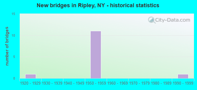
- New bridges - historical statistics
- 11920-1929
- 111950-1959
- 11990-1999


- Bridge Condition - Deck
- 16.7%Good
- 33.3%Satisfactory
- 50.0%Fair

- Bridge Condition - Superstructure
- 16.7%Very good
- 50.0%Satisfactory
- 16.7%Fair
- 16.7%Critical

- Bridge Condition - Substructure
- 16.7%Good
- 50.0%Satisfactory
- 33.3%Fair

- Bridge Condition - Channel
- 50.0%Very good
- 50.0%Good

- Bridge Condition - Culverts
- 50.0%Satisfactory
- 50.0%Fair
Find on map >> Show street view
Structure Number: 103001, Location: 5.9 MI NW SHELDON CORNERS (Lat: 42.244975, Lng: -79.696489), Route carried "on" structure: State highway 76, Year Built: 1928, Status: Open, Structure Length: 1.01m (3.31ft), Average Daily Traffic: 730 (year 2018), Truck Traffic: 5%, Average Future Daily Traffic: 737 (year 2040), Features Intersected: GAGE GULF
Minimum Vertical Clearance: 30+ m (98+ ft), Kilometerpoint: 26.516, Lanes on structure: 2, Base Highway Network: Yes, Owner: State Highway Agency, Approaching Roadway Width: 8.8m (28.9ft), Material/Design: Concrete, Design/Construction: Culvert, Number Of Spans In Main Unit: 1, Length of Maximum Span: 8.8m (28.9ft), Curb-To-Curb Width: 8.5m (27.9ft), Out-to-Out Width: 24.4m (80.1ft)
Condition: Channel: Good, Culverts: Satisfactory, Operating Rating: 47.8 metric tons, Method Used To Determine Operating Rating: Field evaluation and documented engineering judgment, Inventory Rating: 21.7 metric tons, Method Used To Determine Inventory Rating: Field evaluation and documented engineering judgment, Structural Evaluation: Somewhat better than minimum adequacy, Deck Geometry: Somewhat better than minimum adequacy, Waterway Adequacy: Somewhat better than minimum adequacy, Approach Roadway Alignment: High priority of corrective action, Length Of Structure Improvement: 1.00m (3.28ft), Designated Inspection Frequency: Every 24 months, Inspection Date: June 2021, Bridge Improvement Cost: $678,000, Roadway Improvement Cost: $397,000, Total Project Cost: $1,074,000 ( Estimate for 2021), Wearing Surface/Protective System: Wearing Surface: Bituminous
Find on map >> Show street view
Structure Number: 103002, Location: JCT RTS 76 + I-90 (Lat: 42.274947, Lng: -79.716119), Route carried "on" structure: State highway 76, Year Built: 1957, Status: Open, Structure Length: 8.05m (26.41ft), Average Daily Traffic: 383 (year 2020), Truck Traffic: 4%, Average Future Daily Traffic: 386 (year 2040), Design Load: HS 20+Mod, Features Intersected: 90IX EB, RTE I90, TRIB T
Minimum Vertical Clearance: 30+ m (98+ ft), Kilometerpoint: 30.410, Lanes on structure: 2, Lanes under structure: 4, Base Highway Network: Yes, Owner: State Toll Authority, Approaching Roadway Width: 7.3m (24.0ft), Skew: 1 degrees, Material/Design: Steel, Design/Construction: Stringer/Multi-beam, Number Of Spans In Main Unit: 5, Length of Maximum Span: 18.0m (59.1ft), Curb or Sidewalk Widths: Left: 0.8m (2.6ft), Right: 0.8m (2.6ft), Curb-To-Curb Width: 11.0m (36.1ft), Out-to-Out Width: 13.1m (43.0ft)
Condition: Deck: Fair, Superstructure: Fair, Substructure: Fair, Channel: Very good, Operating Rating: 69.9 metric tons, Method Used To Determine Operating Rating: Load Factor (LF), Inventory Rating: 41.7 metric tons, Method Used To Determine Inventory Rating: Load Factor (LF), Structural Evaluation: Somewhat better than minimum adequacy, Deck Geometry: Equal to present desirable criteria, Underclear: High priority of corrective action, Waterway Adequacy: Superior to present desirable criteria, Approach Roadway Alignment: Equal to present desirable criteria, Length Of Structure Improvement: 8.04m (26.38ft), Designated Inspection Frequency: Every 24 months, Inspection Date: October 2021, Bridge Improvement Cost: $3,706,000, Roadway Improvement Cost: $2,170,000, Total Project Cost: $5,876,000 ( Estimate for 2021), Deck Structure Type: Concrete Cast-file-Place, Wearing Surface/Protective System: Wearing Surface: Bituminous, Membrane: Other
Find on map >> Show street view
Structure Number: 105061, Location: AT EXIT 61 OF I90 (Lat: 42.261453, Lng: -79.744706), Route carried "on" structure: State highway 950D, Year Built: 1957, Status: Open, Structure Length: 4.39m (14.40ft), Average Daily Traffic: 658 (year 2018), Truck Traffic: 13%, Average Future Daily Traffic: 664 (year 2040), Design Load: HS 20+Mod, Features Intersected: RTE I90
Minimum Vertical Clearance: 30+ m (98+ ft), Kilometerpoint: 0.837, Lanes on structure: 2, Lanes under structure: 2, Base Highway Network: Yes, Owner: State Toll Authority, Approaching Roadway Width: 7.9m (25.9ft), Material/Design: Steel, Design/Construction: Stringer/Multi-beam, Number Of Spans In Main Unit: 3, Length of Maximum Span: 18.0m (59.1ft), Curb-To-Curb Width: 7.9m (25.9ft), Out-to-Out Width: 10.1m (33.1ft)
Condition: Deck: Satisfactory, Superstructure: Satisfactory, Substructure: Satisfactory, Operating Rating: 73.5 metric tons, Method Used To Determine Operating Rating: Load Factor (LF), Inventory Rating: 43.5 metric tons, Method Used To Determine Inventory Rating: Load Factor (LF), Structural Evaluation: Equal to present minimum criteria, Deck Geometry: Somewhat better than minimum adequacy, Underclear: High priority of corrective action, Approach Roadway Alignment: Equal to present minimum criteria, Length Of Structure Improvement: 4.38m (14.37ft), Designated Inspection Frequency: Every 24 months, Inspection Date: August 2021, Bridge Improvement Cost: $1,658,000, Roadway Improvement Cost: $971,000, Total Project Cost: $2,629,000 ( Estimate for 2021), Deck Structure Type: Concrete Cast-file-Place, Wearing Surface/Protective System: Wearing Surface: Bituminous, Membrane: Other
Find on map >> Show street view
Structure Number: 105062, Location: 0.6 MI NW JCT RTS 20&950D (Lat: 42.262125, Lng: -79.745208), Route carried "on" structure: State highway 950D, Year Built: 1957, Status: Open, Structure Length: 4.48m (14.70ft), Average Daily Traffic: 980 (year 2020), Truck Traffic: 29%, Average Future Daily Traffic: 989 (year 2040), Design Load: HS 20+Mod, Features Intersected: RTE I90
Minimum Vertical Clearance: 30+ m (98+ ft), Kilometerpoint: 0.917, Lanes on structure: 2, Lanes under structure: 2, Base Highway Network: Yes, Owner: State Toll Authority, Approaching Roadway Width: 7.9m (25.9ft), Material/Design: Steel, Design/Construction: Stringer/Multi-beam, Number Of Spans In Main Unit: 3, Length of Maximum Span: 18.0m (59.1ft), Curb-To-Curb Width: 7.9m (25.9ft), Out-to-Out Width: 10.1m (33.1ft)
Condition: Deck: Satisfactory, Superstructure: Satisfactory, Substructure: Satisfactory, Operating Rating: 73.5 metric tons, Method Used To Determine Operating Rating: Load Factor (LF), Inventory Rating: 43.5 metric tons, Method Used To Determine Inventory Rating: Load Factor (LF), Structural Evaluation: Equal to present minimum criteria, Deck Geometry: Somewhat better than minimum adequacy, Underclear: High priority of corrective action, Approach Roadway Alignment: Equal to present minimum criteria, Length Of Structure Improvement: 4.48m (14.70ft), Designated Inspection Frequency: Every 24 months, Inspection Date: August 2021, Bridge Improvement Cost: $1,687,000, Roadway Improvement Cost: $988,000, Total Project Cost: $2,674,000 ( Estimate for 2021), Deck Structure Type: Concrete Cast-file-Place, Wearing Surface/Protective System: Wearing Surface: Bituminous, Membrane: Other
Find on map >> Show street view
Structure Number: 332547, Location: 0.7 MI N OF SOUTH RIPLEY (Lat: 42.204406, Lng: -79.701872), Route carried "on" structure: County highway , Year Built: 1990, Status: Open, Structure Length: 2.59m (8.50ft), Average Daily Traffic: 104 (year 2019), Truck Traffic: 3%, Average Future Daily Traffic: 146 (year 2039), Design Load: HS 20, Features Intersected: TWENTYMILE CREEK, Facility Carried by Structure: COUNTY ROAD 9
Minimum Vertical Clearance: 30+ m (98+ ft), Kilometerpoint: 6.436, Lanes on structure: 2, Owner: County Highway Agency, Approaching Roadway Width: 7.9m (25.9ft), Skew: 4 degrees, Material/Design: Prestressed concrete, Design/Construction: Box Beam or Girders - Multiple, Number Of Spans In Main Unit: 1, Length of Maximum Span: 24.6m (80.7ft), Curb-To-Curb Width: 8.2m (26.9ft), Out-to-Out Width: 8.6m (28.2ft)
Condition: Deck: Good, Superstructure: Very good, Substructure: Fair, Channel: Very good, Operating Rating: 88.9 metric tons, Method Used To Determine Operating Rating: Load Factor (LF), Inventory Rating: 42.6 metric tons, Method Used To Determine Inventory Rating: Load Factor (LF), Structural Evaluation: Somewhat better than minimum adequacy, Deck Geometry: Somewhat better than minimum adequacy, Waterway Adequacy: Equal to present minimum criteria, Approach Roadway Alignment: Equal to present desirable criteria, Length Of Structure Improvement: 2.59m (8.50ft), Designated Inspection Frequency: Every 24 months, Inspection Date: April 2021, Bridge Improvement Cost: $1,094,000, Roadway Improvement Cost: $641,000, Total Project Cost: $1,734,000 ( Estimate for 2021), Wearing Surface/Protective System: Wearing Surface: Bituminous, Membrane: Other
Find on map >> Show street view
Structure Number: 551113, Location: 2.3 MI NE OF RIPLEY INT (Lat: 42.276722, Lng: -79.706775), Route carried "on" structure: Other road , Year Built: 1957, Year Reconstructed: 1999, Status: Open, Structure Length: 8.69m (28.51ft), Average Daily Traffic: 115 (year 2018), Truck Traffic: 4%, Average Future Daily Traffic: 161 (year 2038), Design Load: HS 20+Mod, Features Intersected: 90IX EB, RTE I90, Facility Carried by Structure: WILEY RD
Minimum Vertical Clearance: 30+ m (98+ ft), Kilometerpoint: 0.772, Lanes on structure: 2, Lanes under structure: 4, Owner: State Toll Authority, Approaching Roadway Width: 7.9m (25.9ft), Material/Design: Steel, Design/Construction: Stringer/Multi-beam, Number Of Spans In Main Unit: 5, Length of Maximum Span: 20.1m (65.9ft), Curb or Sidewalk Widths: Left: 0.8m (2.6ft), Right: 0.8m (2.6ft), Curb-To-Curb Width: 7.9m (25.9ft), Out-to-Out Width: 10.1m (33.1ft)
Condition: Deck: Fair, Superstructure: Satisfactory, Substructure: Good, Operating Rating: 67.1 metric tons, Method Used To Determine Operating Rating: Load Factor (LF), Inventory Rating: 39.9 metric tons, Method Used To Determine Inventory Rating: Load Factor (LF), Structural Evaluation: Equal to present minimum criteria, Deck Geometry: Somewhat better than minimum adequacy, Underclear: High priority of corrective action, Approach Roadway Alignment: Equal to present desirable criteria, Length Of Structure Improvement: 8.68m (28.48ft), Designated Inspection Frequency: Every 24 months, Inspection Date: August 2021, Bridge Improvement Cost: $3,048,000, Roadway Improvement Cost: $1,785,000, Total Project Cost: $4,832,000 ( Estimate for 2021), Deck Structure Type: Concrete Cast-file-Place, Wearing Surface/Protective System: Wearing Surface: Monolithic Concrete
Find on map >> Show street view
Structure Number: 551114, Location: 4.8 MI SW EXIT 60 OF I90 (Lat: 42.298325, Lng: -79.657919), Route carried "on" structure: Other road , Year Built: 1955, Year Reconstructed: 1999, Status: Open, Structure Length: 10.36m (33.99ft), Average Daily Traffic: 115 (year 2019), Truck Traffic: 5%, Average Future Daily Traffic: 161 (year 2039), Design Load: HS 20+Mod, Features Intersected: 90IX EB, RTE I90, Facility Carried by Structure: FORSYTH ROAD
Minimum Vertical Clearance: 30+ m (98+ ft), Kilometerpoint: 1.207, Lanes on structure: 2, Lanes under structure: 4, Owner: State Toll Authority, Approaching Roadway Width: 9.8m (32.2ft), Material/Design: Steel, Design/Construction: Stringer/Multi-beam, Number Of Spans In Main Unit: 6, Length of Maximum Span: 19.5m (64.0ft), Curb or Sidewalk Widths: Left: 0.8m (2.6ft), Right: 0.8m (2.6ft), Curb-To-Curb Width: 7.9m (25.9ft), Out-to-Out Width: 10.1m (33.1ft)
Condition: Deck: Fair, Superstructure: Critical, Substructure: Satisfactory, Operating Rating: 57.3 metric tons, Method Used To Determine Operating Rating: Load and Resistance Factor Rating (LRFR) rating reported by rating factor(RF) method using HL-93 loadings, Inventory Rating: 44.1 metric tons, Method Used To Determine Inventory Rating: Load and Resistance Factor Rating (LRFR) rating reported by rating factor(RF) method using HL-93 loadings, Structural Evaluation: High priority of replacement, Deck Geometry: Somewhat better than minimum adequacy, Underclear: High priority of corrective action, Approach Roadway Alignment: Better than present minimum criteria, Length Of Structure Improvement: 10.36m (33.99ft), Designated Inspection Frequency: Every 24 months, Inspection Date: June 2021, Bridge Improvement Cost: $3,551,000, Roadway Improvement Cost: $2,079,000, Total Project Cost: $5,630,000 ( Estimate for 2021), Deck Structure Type: Concrete Cast-file-Place, Wearing Surface/Protective System: Wearing Surface: Monolithic Concrete
Find on map >> Show street view
Structure Number: 552532, Location: 0.6 MI NNW RIPLEY (Lat: 42.274586, Lng: -79.716183), Route carried "on" structure: Interstate 90, Year Built: 1957, Status: Open, Structure Length: 0.85m (2.79ft), Average Daily Traffic: 12,980 (year 2020), Truck Traffic: 51%, Average Future Daily Traffic: 15,459 (year 2040), Design Load: HS 20+Mod, Features Intersected: NY 76 N STATE ST, TRIB T
Minimum Vertical Clearance: 32.69m (107.25ft), Kilometerpoint: 4.553, Lanes on structure: 2, Toll: On Interstate toll segment, Owner: State Toll Authority, Approaching Roadway Width: 13.7m (44.9ft), Skew: 6 degrees, Material/Design: Concrete, Design/Construction: Culvert, Number Of Spans In Main Unit: 1, Length of Maximum Span: 7.3m (24.0ft)
Condition: Channel: Good, Culverts: Fair, Operating Rating: 77.7 metric tons, Method Used To Determine Operating Rating: Field evaluation and documented engineering judgment, Inventory Rating: 32.7 metric tons, Method Used To Determine Inventory Rating: Field evaluation and documented engineering judgment, Structural Evaluation: Somewhat better than minimum adequacy, Waterway Adequacy: Equal to present minimum criteria, Approach Roadway Alignment: Equal to present desirable criteria, Designated Inspection Frequency: Every 24 months, Inspection Date: May 2021
Find on map >> Show street view
Structure Number: 103002, Location: JCT RTS 76 + I-90 (Lat: 42.274947, Lng: -79.716119), Route carried "under" structure: Interstate 90, Year Built: 1957, Structure Length: 0. m, Average Daily Traffic: 15,400 (year 1992), Features Intersected: 90IX EB, RTE I90, TRIB T, Facility Carried by Structure: RTE 76
Minimum Vertical Clearance: 4.47m (14.67ft), Kilometerpoint: 793.494, Lanes on structure: 2, Lanes under structure: 2, Toll: On Interstate toll segment, Material/Design: Steel, Design/Construction: Stringer/Multi-beam, Length of Maximum Span: 18.0m (59.1ft)
Find on map >> Show street view
Structure Number: 105061, Location: AT EXIT 61 OF I90 (Lat: 42.261453, Lng: -79.744706), Route carried "under" structure: Interstate 90, Year Built: 1957, Structure Length: 0. m, Average Daily Traffic: 10,900 (year 1973), Features Intersected: RTE I90, Facility Carried by Structure: RTE 950D
Minimum Vertical Clearance: 4.44m (14.57ft), Kilometerpoint: 796.342, Lanes on structure: 2, Lanes under structure: 2, Toll: On Interstate toll segment, Material/Design: Steel, Design/Construction: Stringer/Multi-beam, Length of Maximum Span: 18.0m (59.1ft)
Find on map >> Show street view
Structure Number: 105062, Location: 0.6 MI NW JCT RTS 20&950D (Lat: 42.262125, Lng: -79.745208), Route carried "under" structure: Interstate 90, Year Built: 1957, Structure Length: 0. m, Average Daily Traffic: 10,900 (year 1973), Features Intersected: RTE I90, Facility Carried by Structure: RTE 950D
Minimum Vertical Clearance: 4.45m (14.60ft), Kilometerpoint: 796.326, Lanes on structure: 2, Lanes under structure: 2, Toll: On Interstate toll segment, Material/Design: Steel, Design/Construction: Stringer/Multi-beam, Length of Maximum Span: 18.0m (59.1ft)
Find on map >> Show street view
Structure Number: 551113, Location: 2.3 MI NE OF RIPLEY INT (Lat: 42.276722, Lng: -79.706775), Route carried "under" structure: Interstate 90, Year Built: 1957, Structure Length: 0. m, Average Daily Traffic: 9,700 (year 1977), Features Intersected: 90IX EB, RTE I90, Facility Carried by Structure: WILEY RD
Minimum Vertical Clearance: 4.42m (14.50ft), Kilometerpoint: 792.706, Lanes on structure: 2, Lanes under structure: 2, Toll: On Interstate toll segment, Material/Design: Steel, Design/Construction: Stringer/Multi-beam, Length of Maximum Span: 20.1m (65.9ft)
Find on map >> Show street view
Structure Number: 551114, Location: 4.8 MI SW EXIT 60 OF I90 (Lat: 42.298325, Lng: -79.657919), Route carried "under" structure: Interstate 90, Year Built: 1955, Structure Length: 0. m, Average Daily Traffic: 9,700 (year 1977), Features Intersected: 90IX EB, RTE I90, Facility Carried by Structure: FORSYTH ROAD
Minimum Vertical Clearance: 4.95m (16.24ft), Kilometerpoint: 787.992, Lanes on structure: 2, Lanes under structure: 2, Toll: On Interstate toll segment, Material/Design: Steel, Design/Construction: Stringer/Multi-beam, Length of Maximum Span: 19.5m (64.0ft)