Bridge Statistics for Preble, New York (NY)
Condition, Traffic, Stress, Structural Evaluation, Project Costs
- National Bridge Inventory (NBI) Statistics
- 16Number of bridges
- 102ft / 31.1mTotal length
- $13,607,000Total costs
- 148,426Total average daily traffic
- 19,678Total average daily truck traffic
- National Bridge Inventory (NBI) Registered Bridges for Preble
- No street view available for this location
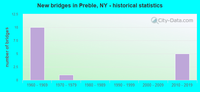
- New bridges - historical statistics
- 101960-1969
- 11970-1979
- 52010-2019


- Bridge Condition - Deck
- 20.0%Excellent
- 20.0%Very good
- 40.0%Good
- 20.0%Fair

- Bridge Condition - Superstructure
- 40.0%Excellent
- 40.0%Good
- 20.0%Satisfactory

- Bridge Condition - Substructure
- 40.0%Excellent
- 40.0%Satisfactory
- 20.0%Fair

- Bridge Condition - Channel
- 25.0%Good
- 37.5%Satisfactory
- 25.0%Fair
- 12.5%Poor

- Bridge Condition - Culverts
- 14.3%Very good
- 14.3%Good
- 57.1%Satisfactory
- 14.3%Fair
Find on map >> Show street view
Structure Number: 103143, Location: 8 MILES N JCT I81 & SH 13 (Lat: 42.707031, Lng: -76.149339), Route carried "on" structure: Interstate 81, Year Built: 1966, Status: Open, Structure Length: 1.04m (3.41ft), Average Daily Traffic: 22,437 (year 2019), Truck Traffic: 17%, Average Future Daily Traffic: 25,151 (year 2040), Design Load: HS 20+Mod, Features Intersected: W B TIOUGHNIOGA R
Minimum Vertical Clearance: 30+ m (98+ ft), Kilometerpoint: 39.099, Lanes on structure: 4, Base Highway Network: Yes, Owner: State Highway Agency, Approaching Roadway Width: 23.2m (76.1ft), Skew: 24 degrees, Material/Design: Concrete continuous, Design/Construction: Culvert, Number Of Spans In Main Unit: 2, Length of Maximum Span: 4.5m (14.8ft)
Condition: Channel: Satisfactory, Culverts: Satisfactory, Operating Rating: 75.5 metric tons, Method Used To Determine Operating Rating: Field evaluation and documented engineering judgment, Inventory Rating: 29.4 metric tons, Method Used To Determine Inventory Rating: Field evaluation and documented engineering judgment, Structural Evaluation: Equal to present minimum criteria, Waterway Adequacy: Superior to present desirable criteria, Approach Roadway Alignment: Equal to present desirable criteria, Length Of Structure Improvement: 1.03m (3.38ft), Designated Inspection Frequency: Every 24 months, Inspection Date: September 2021, Bridge Improvement Cost: $1,068,000, Roadway Improvement Cost: $626,000, Total Project Cost: $1,694,000 ( Estimate for 2021)
Find on map >> Show street view
Structure Number: 1031441, Location: .5 MILE S EXIT 13 OF I81 (Lat: 42.734058, Lng: -76.142258), Route carried "on" structure: Interstate 81, Year Built: 2014, Status: Open, Structure Length: 2.38m (7.81ft), Average Daily Traffic: 13,527 (year 2008), Truck Traffic: 22%, Design Load: HL 93, Features Intersected: PREBLE RD
Minimum Vertical Clearance: 30+ m (98+ ft), Kilometerpoint: 42.140, Lanes on structure: 2, Lanes under structure: 2, Base Highway Network: Yes, Owner: State Highway Agency, Approaching Roadway Width: 12.2m (40.0ft), Material/Design: Steel, Design/Construction: Stringer/Multi-beam, Number Of Spans In Main Unit: 1, Length of Maximum Span: 22.9m (75.1ft), Curb-To-Curb Width: 12.2m (40.0ft), Out-to-Out Width: 13.1m (43.0ft)
Condition: Deck: Very good, Superstructure: Excellent, Substructure: Excellent, Operating Rating: 59.3 metric tons, Method Used To Determine Operating Rating: Load and Resistance Factor Rating (LRFR) rating reported by rating factor(RF) method using HL-93 loadings, Inventory Rating: 46.0 metric tons, Method Used To Determine Inventory Rating: Load and Resistance Factor Rating (LRFR) rating reported by rating factor(RF) method using HL-93 loadings, Structural Evaluation: Superior to present desirable criteria, Deck Geometry: Better than present minimum criteria, Underclear: Better than present minimum criteria, Approach Roadway Alignment: Equal to present desirable criteria, Length Of Structure Improvement: 2.37m (7.78ft), Designated Inspection Frequency: Every 24 months, Inspection Date: May 2020, Bridge Improvement Cost: $1,026,000, Roadway Improvement Cost: $601,000, Total Project Cost: $1,627,000 ( Estimate for 2021), Deck Structure Type: Other, Wearing Surface/Protective System: Wearing Surface: Integral Concrete
Find on map >> Show street view
Structure Number: 1031442, Location: .5 MILE S EXIT 13 OF I81 (Lat: 42.733944, Lng: -76.141739), Route carried "on" structure: Interstate 81, Year Built: 2014, Status: Open, Structure Length: 2.38m (7.81ft), Average Daily Traffic: 11,219 (year 2019), Truck Traffic: 17%, Average Future Daily Traffic: 12,576 (year 2040), Design Load: HL 93, Features Intersected: PREBLE RD
Minimum Vertical Clearance: 30+ m (98+ ft), Kilometerpoint: 42.140, Lanes on structure: 2, Lanes under structure: 2, Base Highway Network: Yes, Owner: State Highway Agency, Approaching Roadway Width: 12.2m (40.0ft), Material/Design: Steel, Design/Construction: Stringer/Multi-beam, Number Of Spans In Main Unit: 1, Length of Maximum Span: 22.9m (75.1ft), Curb-To-Curb Width: 12.2m (40.0ft), Out-to-Out Width: 13.1m (43.0ft)
Condition: Deck: Excellent, Superstructure: Excellent, Substructure: Excellent, Operating Rating: 75.3 metric tons, Method Used To Determine Operating Rating: Load Factor (LF), Inventory Rating: 45.4 metric tons, Method Used To Determine Inventory Rating: Load Factor (LF), Structural Evaluation: Superior to present desirable criteria, Deck Geometry: Better than present minimum criteria, Underclear: Better than present minimum criteria, Approach Roadway Alignment: Equal to present desirable criteria, Length Of Structure Improvement: 2.37m (7.78ft), Designated Inspection Frequency: Every 24 months, Inspection Date: May 2020, Bridge Improvement Cost: $1,026,000, Roadway Improvement Cost: $601,000, Total Project Cost: $1,627,000 ( Estimate for 2021), Deck Structure Type: Other, Wearing Surface/Protective System: Wearing Surface: Integral Concrete
Find on map >> Show street view
Structure Number: 103145, Location: JCT RTS 281 + I-81 (Lat: 42.746267, Lng: -76.137817), Route carried "on" structure: State highway 281, Year Built: 1966, Status: Open, Structure Length: 10.45m (34.28ft), Average Daily Traffic: 1,712 (year 2020), Truck Traffic: 16%, Average Future Daily Traffic: 2,393 (year 2040), Design Load: HS 20, Features Intersected: 81I 81I32023096 NB, RTE
Minimum Vertical Clearance: 30+ m (98+ ft), Kilometerpoint: 20.306, Lanes on structure: 2, Lanes under structure: 4, Base Highway Network: Yes, Owner: State Highway Agency, Approaching Roadway Width: 12.2m (40.0ft), Skew: 3 degrees, Material/Design: Steel, Design/Construction: Stringer/Multi-beam, Number Of Spans In Main Unit: 5, Length of Maximum Span: 23.7m (77.8ft), Curb-To-Curb Width: 9.1m (29.9ft), Out-to-Out Width: 10.8m (35.4ft)
Condition: Deck: Fair, Superstructure: Satisfactory, Substructure: Fair, Operating Rating: 51.7 metric tons, Method Used To Determine Operating Rating: Load Factor (LF), Inventory Rating: 30.8 metric tons, Method Used To Determine Inventory Rating: Load Factor (LF), Structural Evaluation: Somewhat better than minimum adequacy, Deck Geometry: Somewhat better than minimum adequacy, Underclear: High priority of corrective action, Approach Roadway Alignment: Equal to present desirable criteria, Length Of Structure Improvement: 10.45m (34.28ft), Designated Inspection Frequency: Every 24 months, Inspection Date: May 2021, Bridge Improvement Cost: $2,179,000, Roadway Improvement Cost: $1,276,000, Total Project Cost: $3,456,000 ( Estimate for 2021), Deck Structure Type: Concrete Cast-file-Place, Wearing Surface/Protective System: Wearing Surface: Bituminous, Membrane: Preformed Fabric
Find on map >> Show street view
Structure Number: 1031461, Location: 0.5 MI N JCT I81 + SH 281 (Lat: 42.751575, Lng: -76.136383), Route carried "on" structure: Interstate 81, Year Built: 1966, Status: Open, Structure Length: 0.73m (2.40ft), Average Daily Traffic: 14,138 (year 2011), Truck Traffic: 24%, Design Load: HS 20+Mod, Features Intersected: W BR TIOUGHNIOGA
Minimum Vertical Clearance: 30+ m (98+ ft), Kilometerpoint: 44.135, Lanes on structure: 2, Base Highway Network: Yes, Owner: State Highway Agency, Approaching Roadway Width: 11.6m (38.1ft), Skew: 4 degrees, Material/Design: Concrete continuous, Design/Construction: Culvert, Number Of Spans In Main Unit: 2, Length of Maximum Span: 3.3m (10.8ft)
Condition: Channel: Good, Culverts: Good, Operating Rating: 74.9 metric tons, Method Used To Determine Operating Rating: Field evaluation and documented engineering judgment, Inventory Rating: 32.7 metric tons, Method Used To Determine Inventory Rating: Field evaluation and documented engineering judgment, Structural Evaluation: Better than present minimum criteria, Waterway Adequacy: Meets minimum limits, Approach Roadway Alignment: Equal to present desirable criteria, Length Of Structure Improvement: 0.73m (2.40ft), Designated Inspection Frequency: Every 24 months, Inspection Date: April 2020, Bridge Improvement Cost: $196,000, Roadway Improvement Cost: $115,000, Total Project Cost: $311,000 ( Estimate for 2021)
Find on map >> Show street view
Structure Number: 1031462, Location: 0.5 MI N JCT I81 & SH 281 (Lat: 42.751233, Lng: -76.135919), Route carried "on" structure: Interstate 81, Year Built: 1966, Status: Open, Structure Length: 0.73m (2.40ft), Average Daily Traffic: 11,294 (year 2019), Truck Traffic: 17%, Average Future Daily Traffic: 12,660 (year 2040), Design Load: HS 20+Mod, Features Intersected: W BR TIOUGHNIOGA
Minimum Vertical Clearance: 30+ m (98+ ft), Kilometerpoint: 44.135, Lanes on structure: 2, Base Highway Network: Yes, Owner: State Highway Agency, Approaching Roadway Width: 11.0m (36.1ft), Skew: 4 degrees, Material/Design: Concrete continuous, Design/Construction: Culvert, Number Of Spans In Main Unit: 2, Length of Maximum Span: 3.3m (10.8ft)
Condition: Channel: Good, Culverts: Satisfactory, Operating Rating: 74.9 metric tons, Method Used To Determine Operating Rating: Field evaluation and documented engineering judgment, Inventory Rating: 32.7 metric tons, Method Used To Determine Inventory Rating: Field evaluation and documented engineering judgment, Structural Evaluation: Equal to present minimum criteria, Waterway Adequacy: Meets minimum limits, Approach Roadway Alignment: Equal to present desirable criteria, Length Of Structure Improvement: 0.73m (2.40ft), Designated Inspection Frequency: Every 24 months, Inspection Date: April 2020, Bridge Improvement Cost: $186,000, Roadway Improvement Cost: $109,000, Total Project Cost: $295,000 ( Estimate for 2021), Wearing Surface/Protective System: Wearing Surface: Bituminous
Find on map >> Show street view
Structure Number: 103147, Location: 1.4 MI N JCT RTS I-81+281 (Lat: 42.764233, Lng: -76.132022), Route carried "on" structure: County highway , Year Built: 1966, Status: Open, Structure Length: 8.99m (29.49ft), Average Daily Traffic: 249 (year 2019), Truck Traffic: 8%, Average Future Daily Traffic: 349 (year 2039), Design Load: HS 20+Mod, Features Intersected: 81I 81I32023109, RTE I81, Facility Carried by Structure: SONG LAKE XING RD
Minimum Vertical Clearance: 30+ m (98+ ft), Kilometerpoint: 1.239, Lanes on structure: 2, Lanes under structure: 4, Owner: State Highway Agency, Approaching Roadway Width: 7.3m (24.0ft), Skew: 1 degrees, Material/Design: Steel, Design/Construction: Stringer/Multi-beam, Number Of Spans In Main Unit: 5, Length of Maximum Span: 20.7m (67.9ft), Curb-To-Curb Width: 9.1m (29.9ft), Out-to-Out Width: 10.8m (35.4ft)
Condition: Deck: Good, Superstructure: Good, Substructure: Satisfactory, Operating Rating: 42.6 metric tons, Method Used To Determine Operating Rating: Load Factor (LF), Inventory Rating: 25.4 metric tons, Method Used To Determine Inventory Rating: Load Factor (LF), Structural Evaluation: Equal to present minimum criteria, Deck Geometry: Meets minimum limits, Underclear: High priority of corrective action, Approach Roadway Alignment: Equal to present desirable criteria, Length Of Structure Improvement: 8.99m (29.49ft), Designated Inspection Frequency: Every 24 months, Inspection Date: June 2020, Bridge Improvement Cost: $1,900,000, Roadway Improvement Cost: $1,113,000, Total Project Cost: $3,013,000 ( Estimate for 2021), Deck Structure Type: Concrete Cast-file-Place, Wearing Surface/Protective System: Wearing Surface: Monolithic Concrete
Find on map >> Show street view
Structure Number: 1079461, Location: 2.1 mi N Jct Rt 281 & I81 (Lat: 42.775867, Lng: -76.127269), Route carried "on" structure: Interstate 81, Year Built: 1964, Status: Open, Structure Length: 0.61m (2.00ft), Average Daily Traffic: 14,138 (year 2011), Truck Traffic: 24%, Features Intersected: Tully Lake Creek
Minimum Vertical Clearance: 30+ m (98+ ft), Kilometerpoint: 46.935, Lanes on structure: 2, Base Highway Network: Yes, Owner: State Highway Agency, Approaching Roadway Width: 12.2m (40.0ft), Material/Design: Concrete, Design/Construction: Culvert, Number Of Spans In Main Unit: 2, Length of Maximum Span: 2.4m (7.9ft)
Condition: Channel: Fair, Culverts: Satisfactory, Operating Rating: 74.3 metric tons, Method Used To Determine Operating Rating: Field evaluation and documented engineering judgment, Inventory Rating: 32.7 metric tons, Method Used To Determine Inventory Rating: Field evaluation and documented engineering judgment, Structural Evaluation: Equal to present minimum criteria, Waterway Adequacy: Equal to present minimum criteria, Approach Roadway Alignment: Equal to present desirable criteria, Length Of Structure Improvement: 0.60m (1.97ft), Designated Inspection Frequency: Every 24 months, Inspection Date: November 2021, Bridge Improvement Cost: $172,000, Roadway Improvement Cost: $101,000, Total Project Cost: $273,000 ( Estimate for 2021)
Find on map >> Show street view
Structure Number: 1079462, Location: 2.1 mi N Jct Rt 281 (Lat: 42.775967, Lng: -76.126681), Route carried "on" structure: Interstate 81, Year Built: 1964, Status: Open, Structure Length: 0.61m (2.00ft), Average Daily Traffic: 11,294 (year 2019), Truck Traffic: 17%, Average Future Daily Traffic: 12,660 (year 2040), Features Intersected: Tully Lake Creek
Minimum Vertical Clearance: 30+ m (98+ ft), Kilometerpoint: 46.935, Lanes on structure: 2, Base Highway Network: Yes, Owner: State Highway Agency, Approaching Roadway Width: 12.2m (40.0ft), Material/Design: Concrete, Design/Construction: Culvert, Number Of Spans In Main Unit: 2, Length of Maximum Span: 2.4m (7.9ft)
Condition: Channel: Fair, Culverts: Satisfactory, Operating Rating: 74.3 metric tons, Method Used To Determine Operating Rating: Field evaluation and documented engineering judgment, Inventory Rating: 32.7 metric tons, Method Used To Determine Inventory Rating: Field evaluation and documented engineering judgment, Structural Evaluation: Equal to present minimum criteria, Waterway Adequacy: Meets minimum limits, Approach Roadway Alignment: Equal to present desirable criteria, Length Of Structure Improvement: 0.60m (1.97ft), Designated Inspection Frequency: Every 24 months, Inspection Date: November 2021, Bridge Improvement Cost: $172,000, Roadway Improvement Cost: $101,000, Total Project Cost: $273,000 ( Estimate for 2021)
Find on map >> Show street view
Structure Number: 220746, Location: 1.3 MI SE OF PREBLE (Lat: 42.718742, Lng: -76.135444), Route carried "on" structure: Other road , Year Built: 1964, Year Reconstructed: 1997, Status: Open, Structure Length: 1.19m (3.90ft), Average Daily Traffic: 67 (year 2019), Truck Traffic: 7%, Average Future Daily Traffic: 94 (year 2039), Design Load: HS 25 or greater, Features Intersected: W B TIOUGHNIOGA R, Facility Carried by Structure: EAST CLARK ROAD
Minimum Vertical Clearance: 30+ m (98+ ft), Kilometerpoint: 0.611, Lanes on structure: 1, Owner: Town or Township Highway Agency, Approaching Roadway Width: 4.9m (16.1ft), Material/Design: Prestressed concrete, Design/Construction: Box Beam or Girders - Multiple, Number Of Spans In Main Unit: 1, Length of Maximum Span: 11.2m (36.7ft), Curb-To-Curb Width: 4.1m (13.5ft), Out-to-Out Width: 4.9m (16.1ft)
Condition: Deck: Good, Superstructure: Good, Substructure: Satisfactory, Channel: Satisfactory, Operating Rating: 88.0 metric tons, Method Used To Determine Operating Rating: Load Factor (LF), Inventory Rating: 49.0 metric tons, Method Used To Determine Inventory Rating: Load Factor (LF), Structural Evaluation: Equal to present minimum criteria, Deck Geometry: Somewhat better than minimum adequacy, Waterway Adequacy: Somewhat better than minimum adequacy, Approach Roadway Alignment: Somewhat better than minimum adequacy, Length Of Structure Improvement: 1.18m (3.87ft), Designated Inspection Frequency: Every 24 months, Inspection Date: April 2021, Bridge Improvement Cost: $226,000, Roadway Improvement Cost: $132,000, Total Project Cost: $359,000 ( Estimate for 2021), Wearing Surface/Protective System: Wearing Surface: Bituminous
Find on map >> Show street view
Structure Number: 226317, Location: 3.2 MILES NE OF PREBLE (Lat: 42.775728, Lng: -76.127667), Route carried "on" structure: Other road , Year Built: 1978, Status: Open, Structure Length: 0.70m (2.30ft), Average Daily Traffic: 145 (year 2018), Truck Traffic: 8%, Average Future Daily Traffic: 203 (year 2038), Features Intersected: TULLY LAKE CREEK, Facility Carried by Structure: SAULSBURY ROAD
Minimum Vertical Clearance: 30+ m (98+ ft), Kilometerpoint: 1.545, Lanes on structure: 2, Owner: Town or Township Highway Agency, Approaching Roadway Width: 10.1m (33.1ft), Skew: 4 degrees, Material/Design: Steel, Design/Construction: Culvert, Number Of Spans In Main Unit: 2, Length of Maximum Span: 3.0m (9.8ft)
Condition: Channel: Satisfactory, Culverts: Fair, Operating Rating: 74.5 metric tons, Method Used To Determine Operating Rating: Field evaluation and documented engineering judgment, Inventory Rating: 29.4 metric tons, Method Used To Determine Inventory Rating: Field evaluation and documented engineering judgment, Structural Evaluation: Somewhat better than minimum adequacy, Waterway Adequacy: Meets minimum limits, Approach Roadway Alignment: Equal to present minimum criteria, Length Of Structure Improvement: 0.70m (2.30ft), Designated Inspection Frequency: Every 24 months, Inspection Date: June 2021, Bridge Improvement Cost: $163,000, Roadway Improvement Cost: $96,000, Total Project Cost: $259,000 ( Estimate for 2021)
Find on map >> Show street view
Structure Number: 331195, Location: 1 MILE SE OF PREBLE (Lat: 42.732139, Lng: -76.130694), Route carried "on" structure: County highway , Year Built: 2012, Status: Open, Structure Length: 1.25m (4.10ft), Average Daily Traffic: 296 (year 2020), Truck Traffic: 8%, Average Future Daily Traffic: 414 (year 2040), Features Intersected: WB TIOUGHNIOGA RV, Facility Carried by Structure: CR108B PREBLE RD
Minimum Vertical Clearance: 30+ m (98+ ft), Kilometerpoint: 1.480, Lanes on structure: 2, Owner: County Highway Agency, Approaching Roadway Width: 9.1m (29.9ft), Material/Design: Steel, Design/Construction: Culvert, Number Of Spans In Main Unit: 4, Length of Maximum Span: 2.4m (7.9ft)
Condition: Channel: Poor, Culverts: Very good, Operating Rating: 74.3 metric tons, Method Used To Determine Operating Rating: Field evaluation and documented engineering judgment, Inventory Rating: 40.8 metric tons, Method Used To Determine Inventory Rating: Field evaluation and documented engineering judgment, Structural Evaluation: Equal to present desirable criteria, Waterway Adequacy: Somewhat better than minimum adequacy, Approach Roadway Alignment: Better than present minimum criteria, Length Of Structure Improvement: 1.24m (4.07ft), Designated Inspection Frequency: Every 24 months, Inspection Date: November 2020, Bridge Improvement Cost: $265,000, Roadway Improvement Cost: $155,000, Total Project Cost: $420,000 ( Estimate for 2021)
Find on map >> Show street view
Structure Number: 1031441, Location: .5 MILE S EXIT 13 OF I81 (Lat: 42.734058, Lng: -76.142258), Route carried "under" structure: County highway , Year Built: 2014, Structure Length: 0. m, Average Daily Traffic: 207 (year 2019), Truck Traffic: 7%, Features Intersected: PREBLE RD, Facility Carried by Structure: RTE I81
Minimum Vertical Clearance: 4.88m (16.01ft), Kilometerpoint: 0.000, Lanes on structure: 2, Lanes under structure: 2, Material/Design: Steel, Design/Construction: Stringer/Multi-beam, Length of Maximum Span: 22.9m (75.1ft)
Find on map >> Show street view
Structure Number: 1031442, Location: .5 MILE S EXIT 13 OF I81 (Lat: 42.733944, Lng: -76.141739), Route carried "under" structure: County highway , Year Built: 2014, Structure Length: 0. m, Average Daily Traffic: 207 (year 2019), Truck Traffic: 7%, Features Intersected: PREBLE RD, Facility Carried by Structure: RTE I81
Minimum Vertical Clearance: 4.88m (16.01ft), Kilometerpoint: 0.499, Lanes on structure: 2, Lanes under structure: 2, Material/Design: Steel, Design/Construction: Stringer/Multi-beam, Length of Maximum Span: 22.9m (75.1ft)
Find on map >> Show street view
Structure Number: 103145, Location: JCT RTS 281 + I-81 (Lat: 42.746267, Lng: -76.137817), Route carried "under" structure: Interstate 81, Year Built: 1966, Structure Length: 0. m, Average Daily Traffic: 22,061 (year 1999), Features Intersected: 81I 81I32023096 NB, RTE
Minimum Vertical Clearance: 4.93m (16.17ft), Kilometerpoint: 15.446, Lanes on structure: 2, Lanes under structure: 2, Material/Design: Steel, Design/Construction: Stringer/Multi-beam, Length of Maximum Span: 23.7m (77.8ft)
Find on map >> Show street view
Structure Number: 103147, Location: 1.4 MI N JCT RTS I-81+281 (Lat: 42.764233, Lng: -76.132022), Route carried "under" structure: Interstate 81, Year Built: 1966, Structure Length: 0. m, Average Daily Traffic: 25,435 (year 1999), Features Intersected: 81I 81I32023109, RTE I81, Facility Carried by Structure: SONG LAKE XING RD
Minimum Vertical Clearance: 5.00m (16.40ft), Kilometerpoint: 17.538, Lanes on structure: 2, Lanes under structure: 2, Material/Design: Steel, Design/Construction: Stringer/Multi-beam, Length of Maximum Span: 20.7m (67.9ft)