Bridge Statistics for Portage, New York (NY)
Condition, Traffic, Stress, Structural Evaluation, Project Costs
- National Bridge Inventory (NBI) Statistics
- 10Number of bridges
- 85ft / 25.9mTotal length
- $12,936,000Total costs
- 7,652Total average daily traffic
- 545Total average daily truck traffic
- National Bridge Inventory (NBI) Registered Bridges for Portage
- No street view available for this location
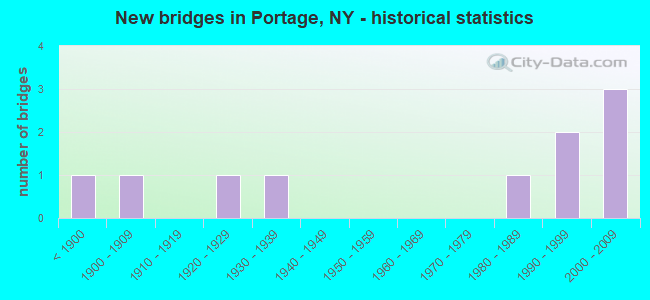
- New bridges - historical statistics
- 1Before 1900
- 11900-1909
- 11920-1929
- 11930-1939
- 11980-1989
- 21990-1999
- 32000-2009


- Bridge Condition - Deck
- 50.0%Excellent
- 25.0%Very good
- 25.0%Satisfactory

- Bridge Condition - Superstructure
- 20.0%Excellent
- 40.0%Very good
- 20.0%Good
- 20.0%Fair

- Bridge Condition - Substructure
- 40.0%Very good
- 40.0%Good
- 20.0%Satisfactory

- Bridge Condition - Channel
- 28.6%Very good
- 57.1%Satisfactory
- 14.3%Fair

- Bridge Condition - Culverts
- 33.3%Very good
- 33.3%Good
- 33.3%Fair
Find on map >> Show street view
Structure Number: 104627, Location: 2.2 MI W JCT RTS 70 & 408 (Lat: 42.557692, Lng: -77.988078), Route carried "on" structure: State highway 70, Year Built: 1994, Status: Open, Structure Length: 3.66m (12.01ft), Average Daily Traffic: 735 (year 2020), Truck Traffic: 21%, Average Future Daily Traffic: 739 (year 2040), Design Load: HS 25 or greater, Features Intersected: KESHEQUA CREEK
Minimum Vertical Clearance: 30+ m (98+ ft), Kilometerpoint: 1.770, Lanes on structure: 2, Base Highway Network: Yes, Owner: State Highway Agency, Approaching Roadway Width: 9.1m (29.9ft), Skew: 2 degrees, Material/Design: Prestressed concrete, Design/Construction: Stringer/Multi-beam, Number Of Spans In Main Unit: 1, Length of Maximum Span: 35.3m (115.8ft), Curb-To-Curb Width: 9.8m (32.2ft), Out-to-Out Width: 10.4m (34.1ft)
Condition: Deck: Excellent, Superstructure: Very good, Substructure: Very good, Channel: Satisfactory, Inventory Rating: 67.1 metric tons, Method Used To Determine Inventory Rating: Load Factor (LF), Structural Evaluation: Equal to present desirable criteria, Deck Geometry: Equal to present minimum criteria, Waterway Adequacy: Superior to present desirable criteria, Approach Roadway Alignment: Equal to present desirable criteria, Length Of Structure Improvement: 3.65m (11.98ft), Designated Inspection Frequency: Every 24 months, Inspection Date: May 2020, Bridge Improvement Cost: $981,000, Roadway Improvement Cost: $575,000, Total Project Cost: $1,556,000 ( Estimate for 2021), Deck Structure Type: Concrete Cast-file-Place, Wearing Surface/Protective System: Wearing Surface: Integral Concrete, Deck Protection: Epoxy Coated Reinforcing
Find on map >> Show street view
Structure Number: 106245, Location: JCT RTE 436 + GENESEE R (Lat: 42.571239, Lng: -78.040550), Route carried "on" structure: State highway 436, Year Built: 1920, Status: Posted for load-capacity, Structure Length: 12.71m (41.70ft), Average Daily Traffic: 2,368 (year 2018), Truck Traffic: 15%, Average Future Daily Traffic: 2,382 (year 2040), Features Intersected: GENESEE RIVER
Minimum Vertical Clearance: 30+ m (98+ ft), Kilometerpoint: 6.951, Lanes on structure: 2, Base Highway Network: Yes, Owner: State Highway Agency, Approaching Roadway Width: 12.2m (40.0ft), Material/Design: Concrete, Design/Construction: Arch - Deck, Number Of Spans In Main Unit: 6, Length of Maximum Span: 28.9m (94.8ft), Curb-To-Curb Width: 6.7m (22.0ft), Out-to-Out Width: 7.7m (25.3ft)
Condition: Superstructure: Fair, Substructure: Satisfactory, Channel: Very good, Operating Rating: 40.2 metric tons, Method Used To Determine Operating Rating: Field evaluation and documented engineering judgment, Inventory Rating: 11.7 metric tons, Method Used To Determine Inventory Rating: Field evaluation and documented engineering judgment, Structural Evaluation: High priority of corrective action, Deck Geometry: High priority of replacement, Waterway Adequacy: Meets minimum limits, Approach Roadway Alignment: Meets minimum limits, Length Of Structure Improvement: 12.71m (41.70ft), Designated Inspection Frequency: Every 24 months, Inspection Date: August 2020, Bridge Improvement Cost: $4,402,000, Roadway Improvement Cost: $2,578,000, Total Project Cost: $6,980,000 ( Estimate for 2021), Wearing Surface/Protective System: Wearing Surface: Bituminous
Find on map >> Show street view
Structure Number: 331653, Location: 1.5 MI W OF NUNDA (Lat: 42.576161, Lng: -77.970383), Route carried "on" structure: Other road , Year Built: 1991, Status: Open, Structure Length: 1.62m (5.31ft), Average Daily Traffic: 230 (year 2017), Truck Traffic: 2%, Average Future Daily Traffic: 322 (year 2037), Design Load: HS 20, Features Intersected: KESHEQUA CREEK, Facility Carried by Structure: PARKER ROAD
Minimum Vertical Clearance: 30+ m (98+ ft), Kilometerpoint: 3.443, Lanes on structure: 2, Owner: County Highway Agency, Approaching Roadway Width: 6.7m (22.0ft), Material/Design: Prestressed concrete, Design/Construction: Box Beam or Girders - Multiple, Number Of Spans In Main Unit: 1, Length of Maximum Span: 14.6m (47.9ft), Curb-To-Curb Width: 7.3m (24.0ft), Out-to-Out Width: 7.9m (25.9ft)
Condition: Deck: Satisfactory, Superstructure: Good, Substructure: Very good, Channel: Satisfactory, Operating Rating: 78.0 metric tons, Method Used To Determine Operating Rating: Load Factor (LF), Inventory Rating: 32.7 metric tons, Method Used To Determine Inventory Rating: Load Factor (LF), Structural Evaluation: Better than present minimum criteria, Deck Geometry: Somewhat better than minimum adequacy, Waterway Adequacy: Better than present minimum criteria, Approach Roadway Alignment: Equal to present desirable criteria, Length Of Structure Improvement: 1.61m (5.28ft), Designated Inspection Frequency: Every 24 months, Inspection Date: August 2021, Bridge Improvement Cost: $447,000, Roadway Improvement Cost: $262,000, Total Project Cost: $709,000 ( Estimate for 2021), Wearing Surface/Protective System: Wearing Surface: Monolithic Concrete
Find on map >> Show street view
Structure Number: 331657, Location: .8 MILE WEST OF DALTON (Lat: 42.540650, Lng: -77.966589), Route carried "on" structure: Other road , Year Built: 2009, Status: Open, Structure Length: 3.29m (10.79ft), Average Daily Traffic: 39 (year 2016), Truck Traffic: 5%, Average Future Daily Traffic: 55 (year 2036), Design Load: HS 25 or greater, Features Intersected: NORFOLK SOUTHERN, Facility Carried by Structure: HUNTS HOLLOW ROAD
Minimum Vertical Clearance: 30+ m (98+ ft), Kilometerpoint: 0.515, Lanes on structure: 2, Owner: Railroad, Maintenance Responsibility: County Highway Agency, Approaching Roadway Width: 8.5m (27.9ft), Skew: 3 degrees, Material/Design: Steel, Design/Construction: Stringer/Multi-beam, Number Of Spans In Main Unit: 1, Length of Maximum Span: 30.5m (100.1ft), Curb-To-Curb Width: 8.8m (28.9ft), Out-to-Out Width: 9.8m (32.2ft)
Condition: Deck: Very good, Superstructure: Very good, Substructure: Good, Operating Rating: 82.6 metric tons, Method Used To Determine Operating Rating: Load Factor (LF), Inventory Rating: 49.0 metric tons, Method Used To Determine Inventory Rating: Load Factor (LF), Structural Evaluation: Better than present minimum criteria, Deck Geometry: Better than present minimum criteria, Underclear: Equal to present minimum criteria, Approach Roadway Alignment: Equal to present desirable criteria, Length Of Structure Improvement: 3.29m (10.79ft), Designated Inspection Frequency: Every 24 months, Inspection Date: November 2021, Bridge Improvement Cost: $1,529,000, Roadway Improvement Cost: $896,000, Total Project Cost: $2,425,000 ( Estimate for 2021), Deck Structure Type: Concrete Cast-file-Place, Wearing Surface/Protective System: Wearing Surface: Integral Concrete, Deck Protection: Epoxy Coated Reinforcing
Find on map >> Show street view
Structure Number: 331658, Location: 1 MI. SW OF DALTON (Lat: 42.537664, Lng: -77.959300), Route carried "on" structure: Other road , Year Built: 1986, Status: Open, Structure Length: 1.04m (3.41ft), Average Daily Traffic: 191 (year 2017), Average Future Daily Traffic: 267 (year 2037), Design Load: HS 20, Features Intersected: KESHEQUA CREEK, Facility Carried by Structure: CHEESE FACTORY RD
Minimum Vertical Clearance: 30+ m (98+ ft), Kilometerpoint: 0.354, Lanes on structure: 2, Owner: County Highway Agency, Approaching Roadway Width: 6.1m (20.0ft), Skew: 2 degrees, Material/Design: Steel, Design/Construction: Culvert, Number Of Spans In Main Unit: 1, Length of Maximum Span: 10.0m (32.8ft)
Condition: Channel: Satisfactory, Culverts: Fair, Operating Rating: 79.0 metric tons, Method Used To Determine Operating Rating: Field evaluation and documented engineering judgment, Inventory Rating: 29.4 metric tons, Method Used To Determine Inventory Rating: Field evaluation and documented engineering judgment, Structural Evaluation: Somewhat better than minimum adequacy, Waterway Adequacy: Better than present minimum criteria, Approach Roadway Alignment: Equal to present desirable criteria, Length Of Structure Improvement: 1.03m (3.38ft), Designated Inspection Frequency: Every 24 months, Inspection Date: August 2021, Bridge Improvement Cost: $113,000, Roadway Improvement Cost: $66,000, Total Project Cost: $180,000 ( Estimate for 2021)
Find on map >> Show street view
Structure Number: 331659, Location: 1.7 MI SW OF DALTON (Lat: 42.519056, Lng: -77.963075), Route carried "on" structure: Other road , Year Built: 2008, Status: Open, Structure Length: 0.76m (2.49ft), Average Daily Traffic: 18 (year 2016), Truck Traffic: 5%, Average Future Daily Traffic: 25 (year 2036), Features Intersected: KESHEQUA CREEK, Facility Carried by Structure: DOAN ROAD
Minimum Vertical Clearance: 30+ m (98+ ft), Kilometerpoint: 0.113, Lanes on structure: 2, Owner: County Highway Agency, Approaching Roadway Width: 7.9m (25.9ft), Skew: 2 degrees, Material/Design: Concrete, Design/Construction: Culvert, Number Of Spans In Main Unit: 1, Length of Maximum Span: 7.3m (24.0ft), Curb-To-Curb Width: 7.9m (25.9ft), Out-to-Out Width: 10.1m (33.1ft)
Condition: Channel: Satisfactory, Culverts: Very good, Operating Rating: 98.9 metric tons, Method Used To Determine Operating Rating: Load Factor (LF), Inventory Rating: 59.0 metric tons, Method Used To Determine Inventory Rating: Load Factor (LF), Structural Evaluation: Equal to present desirable criteria, Deck Geometry: Equal to present minimum criteria, Waterway Adequacy: Somewhat better than minimum adequacy, Approach Roadway Alignment: Somewhat better than minimum adequacy, Length Of Structure Improvement: 0.76m (2.49ft), Designated Inspection Frequency: Every 24 months, Inspection Date: July 2020, Bridge Improvement Cost: $137,000, Roadway Improvement Cost: $80,000, Total Project Cost: $218,000 ( Estimate for 2021), Wearing Surface/Protective System: Wearing Surface: Other
Find on map >> Show street view
Structure Number: 33166, Location: 1.4 MI SW OF DALTON (Lat: 42.522281, Lng: -77.959283), Route carried "on" structure: City street , Year Built: 1900, Year Reconstructed: 2009, Status: Open, Structure Length: 1.46m (4.79ft), Average Daily Traffic: 69 (year 2017), Truck Traffic: 3%, Average Future Daily Traffic: 97 (year 2037), Design Load: HS 25 or greater, Features Intersected: KESHEQUA CREEK, Facility Carried by Structure: BAKER ROAD
Minimum Vertical Clearance: 30+ m (98+ ft), Kilometerpoint: 0.515, Lanes on structure: 2, Owner: County Highway Agency, Approaching Roadway Width: 6.7m (22.0ft), Material/Design: Wood or Timber, Design/Construction: Slab, Number Of Spans In Main Unit: 1, Length of Maximum Span: 14.0m (45.9ft), Curb-To-Curb Width: 7.3m (24.0ft), Out-to-Out Width: 7.9m (25.9ft)
Condition: Deck: Excellent, Superstructure: Excellent, Substructure: Good, Channel: Fair, Operating Rating: 71.7 metric tons, Method Used To Determine Operating Rating: Load Factor (LF), Inventory Rating: 53.5 metric tons, Method Used To Determine Inventory Rating: Load Factor (LF), Structural Evaluation: Better than present minimum criteria, Deck Geometry: Equal to present minimum criteria, Waterway Adequacy: Better than present minimum criteria, Approach Roadway Alignment: Equal to present desirable criteria, Length Of Structure Improvement: 1.46m (4.79ft), Designated Inspection Frequency: Every 24 months, Inspection Date: May 2021, Bridge Improvement Cost: $323,000, Roadway Improvement Cost: $189,000, Total Project Cost: $513,000 ( Estimate for 2021), Wearing Surface/Protective System: Wearing Surface: Bituminous, Membrane: Other
Find on map >> Show street view
Structure Number: 336994, Location: 2 MILES SW OF NUNDA (Lat: 42.552628, Lng: -77.977869), Route carried "on" structure: County highway , Year Built: 2003, Status: Open, Structure Length: 1.34m (4.40ft), Average Daily Traffic: 249 (year 2016), Truck Traffic: 12%, Average Future Daily Traffic: 349 (year 2036), Design Load: HS 25 or greater, Features Intersected: KESHEQUA CREEK, Facility Carried by Structure: COUNTY ROAD 7
Minimum Vertical Clearance: 30+ m (98+ ft), Kilometerpoint: 2.027, Lanes on structure: 2, Owner: County Highway Agency, Approaching Roadway Width: 6.4m (21.0ft), Material/Design: Concrete, Design/Construction: Culvert, Number Of Spans In Main Unit: 1, Length of Maximum Span: 12.8m (42.0ft)
Condition: Channel: Very good, Culverts: Good, Operating Rating: 81.6 metric tons, Method Used To Determine Operating Rating: Field evaluation and documented engineering judgment, Inventory Rating: 40.8 metric tons, Method Used To Determine Inventory Rating: Field evaluation and documented engineering judgment, Structural Evaluation: Better than present minimum criteria, Waterway Adequacy: Superior to present desirable criteria, Approach Roadway Alignment: Equal to present desirable criteria, Length Of Structure Improvement: 1.34m (4.40ft), Designated Inspection Frequency: Every 24 months, Inspection Date: May 2021, Bridge Improvement Cost: $224,000, Roadway Improvement Cost: $131,000, Total Project Cost: $355,000 ( Estimate for 2021)
Find on map >> Show street view
Structure Number: 703578, Location: 0.8 MI NW PORTAGEVILLE (Lat: 42.578044, Lng: -78.050142), Route carried "under" structure: State lands road , Year Built: 1875, Structure Length: 0. m, Average Daily Traffic: 1,000 (year 2021), Features Intersected: GENESEE RIVER, STATE PAR, Facility Carried by Structure: NORFOLK SOUTHERN
Minimum Vertical Clearance: 7.01m (23.00ft), Kilometerpoint: 0.000, Lanes under structure: 2, Material/Design: Steel, Design/Construction: Truss - Deck, Length of Maximum Span: 35.9m (117.8ft)
Find on map >> Show street view
Structure Number: 704293, Location: 4.8MI W JCT RTS 436 + 408 (Lat: 42.577633, Lng: -78.029483), Route carried "under" structure: Alternate State highway 436, Year Built: 1931, Structure Length: 0. m, Average Daily Traffic: 2,753 (year 2002), Features Intersected: RTE 436, Facility Carried by Structure: NORFOLK SOUTHERN
Minimum Vertical Clearance: 4.41m (14.47ft), Kilometerpoint: 1.448, Lanes under structure: 2, Material/Design: Steel, Design/Construction: Girder and Floorbeam System, Length of Maximum Span: 18.8m (61.7ft)