Bridge Statistics for Phelps, New York (NY)
Condition, Traffic, Stress, Structural Evaluation, Project Costs
- National Bridge Inventory (NBI) Statistics
- 28Number of bridges
- 256ft / 77.7mTotal length
- $51,872,000Total costs
- 208,152Total average daily traffic
- 39,230Total average daily truck traffic
- National Bridge Inventory (NBI) Registered Bridges for Phelps
- No street view available for this location
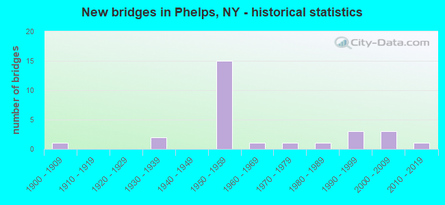
- New bridges - historical statistics
- 11900-1909
- 21930-1939
- 151950-1959
- 11960-1969
- 11970-1979
- 11980-1989
- 31990-1999
- 32000-2009
- 12010-2019

- Reconstructed bridges - Historical Statistics
- 11970-1979
- 51980-1989


- Bridge Condition - Deck
- 5.9%Very good
- 52.9%Good
- 23.5%Satisfactory
- 5.9%Fair
- 11.8%Poor

- Bridge Condition - Superstructure
- 27.8%Very good
- 44.4%Good
- 16.7%Satisfactory
- 5.6%Fair
- 5.6%Poor

- Bridge Condition - Substructure
- 22.2%Very good
- 38.9%Good
- 16.7%Satisfactory
- 22.2%Fair

- Bridge Condition - Channel
- 53.3%Good
- 40.0%Satisfactory
- 6.7%Poor

- Bridge Condition - Culverts
- 33.3%Very good
- 33.3%Good
- 33.3%Fair
Find on map >> Show street view
Structure Number: 1034209, Location: JCT RTS 88 + NYS THRUWAY (Lat: 42.969717, Lng: -77.075778), Route carried "on" structure: Interstate 90, Year Built: 1954, Status: Open, Structure Length: 1.62m (5.31ft), Average Daily Traffic: 27,586 (year 2020), Truck Traffic: 28%, Average Future Daily Traffic: 33,836 (year 2040), Design Load: HS 20, Features Intersected: RTE 88
Minimum Vertical Clearance: 30+ m (98+ ft), Kilometerpoint: 34.256, Lanes on structure: 4, Lanes under structure: 2, Base Highway Network: Yes, Toll: On Interstate toll segment, Owner: State Toll Authority, Approaching Roadway Width: 23.8m (78.1ft), Skew: 21 degrees, Material/Design: Steel, Design/Construction: Stringer/Multi-beam, Number Of Spans In Main Unit: 1, Length of Maximum Span: 14.9m (48.9ft), Curb-To-Curb Width: 36.6m (120.1ft), Out-to-Out Width: 37.5m (123.0ft)
Condition: Deck: Satisfactory, Superstructure: Fair, Substructure: Fair, Operating Rating: 37.2 metric tons, Method Used To Determine Operating Rating: Load Factor (LF), Inventory Rating: 21.8 metric tons, Method Used To Determine Inventory Rating: Load Factor (LF), Structural Evaluation: Somewhat better than minimum adequacy, Deck Geometry: Superior to present desirable criteria, Underclear: High priority of corrective action, Approach Roadway Alignment: Equal to present desirable criteria, Length Of Structure Improvement: 1.61m (5.28ft), Designated Inspection Frequency: Every 24 months, Inspection Date: June 2021, Bridge Improvement Cost: $2,928,000, Roadway Improvement Cost: $1,715,000, Total Project Cost: $4,642,000 ( Estimate for 2021), Deck Structure Type: Concrete Cast-file-Place, Wearing Surface/Protective System: Wearing Surface: Bituminous, Membrane: Other
Find on map >> Show street view
Structure Number: 103422, Location: 0.5 MI N JCT 88 & I90 (Lat: 42.976256, Lng: -77.075906), Route carried "on" structure: State highway 88, Year Built: 1994, Status: Open, Structure Length: 4.69m (15.39ft), Average Daily Traffic: 3,937 (year 2017), Truck Traffic: 7%, Average Future Daily Traffic: 3,961 (year 2040), Design Load: HS 25 or greater, Features Intersected: CANANDAIGUA OUTLT
Minimum Vertical Clearance: 30+ m (98+ ft), Kilometerpoint: 1.496, Lanes on structure: 2, Base Highway Network: Yes, Owner: State Highway Agency, Approaching Roadway Width: 12.2m (40.0ft), Skew: 1 degrees, Material/Design: Steel, Design/Construction: Stringer/Multi-beam, Number Of Spans In Main Unit: 1, Length of Maximum Span: 45.7m (149.9ft), Curb-To-Curb Width: 12.2m (40.0ft), Out-to-Out Width: 12.8m (42.0ft)
Condition: Deck: Very good, Superstructure: Very good, Substructure: Very good, Channel: Good, Operating Rating: 85.3 metric tons, Method Used To Determine Operating Rating: Load Factor (LF), Inventory Rating: 40.8 metric tons, Method Used To Determine Inventory Rating: Load Factor (LF), Structural Evaluation: Equal to present desirable criteria, Deck Geometry: Equal to present minimum criteria, Waterway Adequacy: Somewhat better than minimum adequacy, Approach Roadway Alignment: Equal to present desirable criteria, Length Of Structure Improvement: 4.69m (15.39ft), Designated Inspection Frequency: Every 24 months, Inspection Date: August 2020, Bridge Improvement Cost: $1,495,000, Roadway Improvement Cost: $875,000, Total Project Cost: $2,370,000 ( Estimate for 2021), Deck Structure Type: Concrete Cast-file-Place, Wearing Surface/Protective System: Wearing Surface: Integral Concrete, Deck Protection: Epoxy Coated Reinforcing
Find on map >> Show street view
Structure Number: 10351, Location: JCT RTE 96 & FLINT CREEK (Lat: 42.958372, Lng: -77.060100), Route carried "on" structure: State highway 96, Year Built: 1978, Status: Open, Structure Length: 1.22m (4.00ft), Average Daily Traffic: 6,953 (year 2020), Truck Traffic: 11%, Average Future Daily Traffic: 6,996 (year 2040), Design Load: HS 20, Features Intersected: FLINT CREEK
Minimum Vertical Clearance: 30+ m (98+ ft), Kilometerpoint: 8.431, Lanes on structure: 2, Base Highway Network: Yes, Owner: State Highway Agency, Approaching Roadway Width: 9.1m (29.9ft), Material/Design: Steel, Design/Construction: Culvert, Number Of Spans In Main Unit: 1, Length of Maximum Span: 9.8m (32.2ft), Curb or Sidewalk Widths: Left: 2.1m (6.9ft), Right: 1.5m (4.9ft)
Condition: Channel: Poor, Culverts: Good, Operating Rating: 79.5 metric tons, Method Used To Determine Operating Rating: Field evaluation and documented engineering judgment, Inventory Rating: 32.7 metric tons, Method Used To Determine Inventory Rating: Field evaluation and documented engineering judgment, Structural Evaluation: Better than present minimum criteria, Waterway Adequacy: Equal to present minimum criteria, Approach Roadway Alignment: Equal to present desirable criteria, Length Of Structure Improvement: 1.21m (3.97ft), Designated Inspection Frequency: Every 24 months, Inspection Date: June 2021, Bridge Improvement Cost: $620,000, Roadway Improvement Cost: $363,000, Total Project Cost: $983,000 ( Estimate for 2021)
Find on map >> Show street view
Structure Number: 331802, Location: 2.7 MI SE OF PHELPS (Lat: 42.947381, Lng: -77.010994), Route carried "on" structure: County highway , Year Built: 1989, Status: Open, Structure Length: 4.39m (14.40ft), Average Daily Traffic: 1,124 (year 2017), Truck Traffic: 11%, Average Future Daily Traffic: 1,574 (year 2037), Design Load: HS 20, Features Intersected: CANANDAIGUA OUTLT, Facility Carried by Structure: PREEMPTION RD CR6
Minimum Vertical Clearance: 30+ m (98+ ft), Kilometerpoint: 6.629, Lanes on structure: 2, Owner: County Highway Agency, Approaching Roadway Width: 10.4m (34.1ft), Material/Design: Steel, Design/Construction: Stringer/Multi-beam, Number Of Spans In Main Unit: 2, Length of Maximum Span: 21.3m (69.9ft), Curb-To-Curb Width: 10.4m (34.1ft), Out-to-Out Width: 11.0m (36.1ft)
Condition: Deck: Good, Superstructure: Good, Substructure: Good, Channel: Satisfactory, Operating Rating: 78.4 metric tons, Method Used To Determine Operating Rating: Load and Resistance Factor Rating (LRFR) rating reported by rating factor(RF) method using HL-93 loadings, Inventory Rating: 60.3 metric tons, Method Used To Determine Inventory Rating: Load and Resistance Factor Rating (LRFR) rating reported by rating factor(RF) method using HL-93 loadings, Structural Evaluation: Better than present minimum criteria, Deck Geometry: Equal to present minimum criteria, Waterway Adequacy: Meets minimum limits, Approach Roadway Alignment: Equal to present desirable criteria, Length Of Structure Improvement: 4.38m (14.37ft), Designated Inspection Frequency: Every 24 months, Inspection Date: June 2020, Bridge Improvement Cost: $1,176,000, Roadway Improvement Cost: $689,000, Total Project Cost: $1,865,000 ( Estimate for 2021), Deck Structure Type: Concrete Cast-file-Place, Wearing Surface/Protective System: Wearing Surface: Integral Concrete, Deck Protection: Epoxy Coated Reinforcing
Find on map >> Show street view
Structure Number: 331811, Location: 3MI NW OF PHELPS (Lat: 42.985806, Lng: -77.097836), Route carried "on" structure: Other road , Year Built: 1932, Year Reconstructed: 1991, Status: Open, Structure Length: 3.41m (11.19ft), Average Daily Traffic: 185 (year 2016), Truck Traffic: 3%, Average Future Daily Traffic: 259 (year 2036), Design Load: HS 20, Features Intersected: CANANDAIGUA OUTLT, Facility Carried by Structure: STRYKER ROAD
Minimum Vertical Clearance: 30+ m (98+ ft), Kilometerpoint: 1.191, Lanes on structure: 2, Owner: County Highway Agency, Approaching Roadway Width: 6.1m (20.0ft), Material/Design: Wood or Timber, Design/Construction: Stringer/Multi-beam, Number Of Spans In Main Unit: 2, Length of Maximum Span: 16.7m (54.8ft), Curb-To-Curb Width: 6.5m (21.3ft), Out-to-Out Width: 6.9m (22.6ft)
Condition: Deck: Good, Superstructure: Good, Substructure: Satisfactory, Channel: Satisfactory, Operating Rating: 56.2 metric tons, Method Used To Determine Operating Rating: Allowable Stress (AS), Inventory Rating: 38.1 metric tons, Method Used To Determine Inventory Rating: Allowable Stress (AS), Structural Evaluation: Equal to present minimum criteria, Deck Geometry: Meets minimum limits, Waterway Adequacy: Better than present minimum criteria, Approach Roadway Alignment: Equal to present desirable criteria, Length Of Structure Improvement: 3.41m (11.19ft), Designated Inspection Frequency: Every 24 months, Inspection Date: April 2021, Bridge Improvement Cost: $788,000, Roadway Improvement Cost: $461,000, Total Project Cost: $1,249,000 ( Estimate for 2021), Deck Structure Type: Wood or Timber, Wearing Surface/Protective System: Wearing Surface: Bituminous
Find on map >> Show street view
Structure Number: 331818, Location: 1 MI N OF PHELPS (Lat: 42.964358, Lng: -77.057328), Route carried "on" structure: Other road , Year Built: 1969, Status: Open, Structure Length: 3.47m (11.38ft), Average Daily Traffic: 1,080 (year 2017), Truck Traffic: 3%, Average Future Daily Traffic: 1,512 (year 2037), Design Load: HS 20, Features Intersected: CANANDAIGUA OUTLT, Facility Carried by Structure: MARBLETOWN ROAD
Minimum Vertical Clearance: 30+ m (98+ ft), Kilometerpoint: 0.113, Lanes on structure: 2, Owner: County Highway Agency, Approaching Roadway Width: 6.7m (22.0ft), Skew: 1 degrees, Material/Design: Steel, Design/Construction: Stringer/Multi-beam, Number Of Spans In Main Unit: 2, Length of Maximum Span: 16.7m (54.8ft), Curb or Sidewalk Widths: Left: 1.2m (3.9ft), Right: 1.2m (3.9ft), Curb-To-Curb Width: 7.9m (25.9ft), Out-to-Out Width: 11.0m (36.1ft)
Condition: Deck: Good, Superstructure: Good, Substructure: Good, Channel: Good, Operating Rating: 56.2 metric tons, Method Used To Determine Operating Rating: Load Factor (LF), Inventory Rating: 33.6 metric tons, Method Used To Determine Inventory Rating: Load Factor (LF), Structural Evaluation: Better than present minimum criteria, Deck Geometry: Meets minimum limits, Waterway Adequacy: Somewhat better than minimum adequacy, Approach Roadway Alignment: Equal to present minimum criteria, Length Of Structure Improvement: 3.47m (11.38ft), Designated Inspection Frequency: Every 24 months, Inspection Date: December 2020, Bridge Improvement Cost: $1,117,000, Roadway Improvement Cost: $654,000, Total Project Cost: $1,771,000 ( Estimate for 2021), Deck Structure Type: Concrete Cast-file-Place, Wearing Surface/Protective System: Wearing Surface: Bituminous, Membrane: Other
Find on map >> Show street view
Structure Number: 331819, Location: VILLAGE OF PHELPS (Lat: 42.960244, Lng: -77.057117), Route carried "on" structure: County highway , Year Built: 1991, Status: Open, Structure Length: 1.86m (6.10ft), Average Daily Traffic: 754 (year 2017), Truck Traffic: 3%, Average Future Daily Traffic: 1,056 (year 2037), Design Load: HS 20, Features Intersected: FLINT CREEK, Facility Carried by Structure: MILL STREET
Minimum Vertical Clearance: 30+ m (98+ ft), Kilometerpoint: 0.402, Lanes on structure: 2, Owner: County Highway Agency, Approaching Roadway Width: 6.7m (22.0ft), Material/Design: Concrete, Design/Construction: Frame, Number Of Spans In Main Unit: 2, Length of Maximum Span: 9.1m (29.9ft), Curb or Sidewalk Widths: Left: 1.2m (3.9ft), Right: 0.0m, Curb-To-Curb Width: 7.2m (23.6ft), Out-to-Out Width: 9.1m (29.9ft)
Condition: Superstructure: Good, Substructure: Good, Channel: Satisfactory, Operating Rating: 79.1 metric tons, Method Used To Determine Operating Rating: Field evaluation and documented engineering judgment, Inventory Rating: 32.7 metric tons, Method Used To Determine Inventory Rating: Field evaluation and documented engineering judgment, Structural Evaluation: Better than present minimum criteria, Deck Geometry: Meets minimum limits, Waterway Adequacy: Better than present minimum criteria, Approach Roadway Alignment: Better than present minimum criteria, Length Of Structure Improvement: 1.85m (6.07ft), Designated Inspection Frequency: Every 24 months, Inspection Date: April 2021, Bridge Improvement Cost: $426,000, Roadway Improvement Cost: $249,000, Total Project Cost: $675,000 ( Estimate for 2021)
Find on map >> Show street view
Structure Number: 33182, Location: VILLAGE OF PHELPS (Lat: 42.958203, Lng: -77.068003), Route carried "on" structure: Other road , Year Built: 1995, Status: Open, Structure Length: 1.95m (6.40ft), Average Daily Traffic: 379 (year 2017), Truck Traffic: 6%, Average Future Daily Traffic: 531 (year 2037), Design Load: HS 25 or greater, Features Intersected: FLINT CREEK, Facility Carried by Structure: EAGLE STREET
Minimum Vertical Clearance: 30+ m (98+ ft), Kilometerpoint: 0.257, Lanes on structure: 2, Owner: County Highway Agency, Approaching Roadway Width: 9.1m (29.9ft), Material/Design: Prestressed concrete, Design/Construction: Box Beam or Girders - Multiple, Number Of Spans In Main Unit: 1, Length of Maximum Span: 18.8m (61.7ft), Curb-To-Curb Width: 9.1m (29.9ft), Out-to-Out Width: 9.8m (32.2ft)
Condition: Deck: Good, Superstructure: Very good, Substructure: Very good, Channel: Good, Operating Rating: 86.0 metric tons, Method Used To Determine Operating Rating: Field evaluation and documented engineering judgment, Inventory Rating: 40.8 metric tons, Method Used To Determine Inventory Rating: Field evaluation and documented engineering judgment, Structural Evaluation: Equal to present desirable criteria, Deck Geometry: Equal to present minimum criteria, Waterway Adequacy: Equal to present minimum criteria, Approach Roadway Alignment: Equal to present desirable criteria, Length Of Structure Improvement: 1.95m (6.40ft), Designated Inspection Frequency: Every 24 months, Inspection Date: June 2020, Bridge Improvement Cost: $677,000, Roadway Improvement Cost: $396,000, Total Project Cost: $1,073,000 ( Estimate for 2021), Wearing Surface/Protective System: Wearing Surface: Bituminous, Membrane: Other
Find on map >> Show street view
Structure Number: 331837, Location: 1 MI SW OF PHELPS VILLAGE (Lat: 42.945131, Lng: -77.089094), Route carried "on" structure: Other road , Year Built: 2003, Status: Open, Structure Length: 2.26m (7.41ft), Average Daily Traffic: 1,434 (year 2016), Truck Traffic: 5%, Average Future Daily Traffic: 2,008 (year 2036), Design Load: HS 25 or greater, Features Intersected: FLINT CREEK, Facility Carried by Structure: GRIFFITH ROAD
Minimum Vertical Clearance: 30+ m (98+ ft), Kilometerpoint: 0.483, Lanes on structure: 2, Owner: County Highway Agency, Approaching Roadway Width: 6.7m (22.0ft), Material/Design: Prestressed concrete, Design/Construction: Box Beam or Girders - Multiple, Number Of Spans In Main Unit: 1, Length of Maximum Span: 20.4m (66.9ft), Curb-To-Curb Width: 9.1m (29.9ft), Out-to-Out Width: 10.1m (33.1ft)
Condition: Deck: Good, Superstructure: Very good, Substructure: Very good, Channel: Good, Operating Rating: 76.1 metric tons, Method Used To Determine Operating Rating: Load and Resistance Factor Rating (LRFR) rating reported by rating factor(RF) method using HL-93 loadings, Inventory Rating: 58.6 metric tons, Method Used To Determine Inventory Rating: Load and Resistance Factor Rating (LRFR) rating reported by rating factor(RF) method using HL-93 loadings, Structural Evaluation: Equal to present desirable criteria, Deck Geometry: Somewhat better than minimum adequacy, Waterway Adequacy: Better than present minimum criteria, Approach Roadway Alignment: Better than present minimum criteria, Length Of Structure Improvement: 2.25m (7.38ft), Designated Inspection Frequency: Every 24 months, Inspection Date: July 2021, Bridge Improvement Cost: $683,000, Roadway Improvement Cost: $400,000, Total Project Cost: $1,083,000 ( Estimate for 2021), Deck Structure Type: Concrete Cast-file-Place, Wearing Surface/Protective System: Wearing Surface: Integral Concrete, Deck Protection: Epoxy Coated Reinforcing
Find on map >> Show street view
Structure Number: 331838, Location: VILLAGE OF PHELPS (Lat: 42.960408, Lng: -77.075136), Route carried "on" structure: Other road , Year Built: 1939, Year Reconstructed: 1993, Status: Open, Structure Length: 2.68m (8.79ft), Average Daily Traffic: 2,144 (year 2017), Truck Traffic: 5%, Average Future Daily Traffic: 3,002 (year 2037), Design Load: HS 25 or greater, Features Intersected: FLINT CREEK, Facility Carried by Structure: NEWARK STREET
Minimum Vertical Clearance: 30+ m (98+ ft), Kilometerpoint: 0.225, Lanes on structure: 2, Owner: County Highway Agency, Approaching Roadway Width: 7.6m (24.9ft), Skew: 1 degrees, Material/Design: Prestressed concrete, Design/Construction: Box Beam or Girders - Multiple, Number Of Spans In Main Unit: 2, Length of Maximum Span: 12.8m (42.0ft), Curb-To-Curb Width: 9.2m (30.2ft), Out-to-Out Width: 9.8m (32.2ft)
Condition: Deck: Good, Superstructure: Satisfactory, Substructure: Satisfactory, Channel: Satisfactory, Operating Rating: 57.0 metric tons, Method Used To Determine Operating Rating: Load and Resistance Factor Rating (LRFR) rating reported by rating factor(RF) method using HL-93 loadings, Inventory Rating: 43.7 metric tons, Method Used To Determine Inventory Rating: Load and Resistance Factor Rating (LRFR) rating reported by rating factor(RF) method using HL-93 loadings, Structural Evaluation: Equal to present minimum criteria, Deck Geometry: Meets minimum limits, Waterway Adequacy: Equal to present desirable criteria, Approach Roadway Alignment: Equal to present desirable criteria, Length Of Structure Improvement: 2.68m (8.79ft), Designated Inspection Frequency: Every 24 months, Inspection Date: June 2020, Bridge Improvement Cost: $619,000, Roadway Improvement Cost: $362,000, Total Project Cost: $981,000 ( Estimate for 2021), Wearing Surface/Protective System: Wearing Surface: Bituminous, Membrane: Other
Find on map >> Show street view
Structure Number: 33184, Location: 1 MI NW OF EXIT 42 - I90 (Lat: 42.957767, Lng: -76.989917), Route carried "on" structure: Other road , Year Built: 2002, Status: Open, Structure Length: 4.63m (15.19ft), Average Daily Traffic: 701 (year 2020), Truck Traffic: 6%, Average Future Daily Traffic: 981 (year 2040), Design Load: HS 25 or greater, Features Intersected: CANANDAIGUA OUTLT, Facility Carried by Structure: FISHER ROAD
Minimum Vertical Clearance: 30+ m (98+ ft), Kilometerpoint: 2.237, Lanes on structure: 2, Owner: County Highway Agency, Approaching Roadway Width: 8.5m (27.9ft), Material/Design: Steel, Design/Construction: Stringer/Multi-beam, Number Of Spans In Main Unit: 1, Length of Maximum Span: 46.0m (150.9ft), Curb-To-Curb Width: 9.0m (29.5ft), Out-to-Out Width: 10.0m (32.8ft)
Condition: Deck: Good, Superstructure: Very good, Substructure: Good, Channel: Good, Inventory Rating: 76.2 metric tons, Method Used To Determine Inventory Rating: Load Factor (LF), Structural Evaluation: Better than present minimum criteria, Deck Geometry: Somewhat better than minimum adequacy, Waterway Adequacy: Better than present minimum criteria, Approach Roadway Alignment: Equal to present minimum criteria, Length Of Structure Improvement: 4.63m (15.19ft), Designated Inspection Frequency: Every 24 months, Inspection Date: July 2021, Bridge Improvement Cost: $1,135,000, Roadway Improvement Cost: $665,000, Total Project Cost: $1,800,000 ( Estimate for 2021), Deck Structure Type: Concrete Cast-file-Place, Wearing Surface/Protective System: Wearing Surface: Integral Concrete, Deck Protection: Galvanized Reinforcing
Find on map >> Show street view
Structure Number: 331854, Location: IN VILLAGE OF PHELPS (Lat: 42.960492, Lng: -77.048775), Route carried "on" structure: Other road , Year Built: 2011, Status: Open, Structure Length: 4.08m (13.39ft), Average Daily Traffic: 623 (year 2016), Truck Traffic: 3%, Average Future Daily Traffic: 872 (year 2036), Design Load: HL 93, Features Intersected: CANANDAIGUA OUTLET, Facility Carried by Structure: NORTH WAYNE ST
Minimum Vertical Clearance: 30+ m (98+ ft), Kilometerpoint: 0.016, Lanes on structure: 2, Owner: County Highway Agency, Approaching Roadway Width: 12.8m (42.0ft), Skew: 2 degrees, Material/Design: Steel, Design/Construction: Stringer/Multi-beam, Number Of Spans In Main Unit: 1, Length of Maximum Span: 39.6m (129.9ft), Curb or Sidewalk Widths: Left: 2.1m (6.9ft), Right: 2.1m (6.9ft), Curb-To-Curb Width: 8.4m (27.6ft), Out-to-Out Width: 13.8m (45.3ft)
Condition: Deck: Good, Superstructure: Very good, Substructure: Very good, Channel: Good, Operating Rating: 78.9 metric tons, Method Used To Determine Operating Rating: Load Factor (LF), Inventory Rating: 47.2 metric tons, Method Used To Determine Inventory Rating: Load Factor (LF), Structural Evaluation: Equal to present desirable criteria, Deck Geometry: Somewhat better than minimum adequacy, Waterway Adequacy: Equal to present minimum criteria, Approach Roadway Alignment: Equal to present desirable criteria, Length Of Structure Improvement: 4.08m (13.39ft), Designated Inspection Frequency: Every 24 months, Inspection Date: November 2021, Bridge Improvement Cost: $1,573,000, Roadway Improvement Cost: $921,000, Total Project Cost: $2,494,000 ( Estimate for 2021), Deck Structure Type: Concrete Cast-file-Place, Wearing Surface/Protective System: Wearing Surface: Integral Concrete, Deck Protection: Epoxy Coated Reinforcing
Find on map >> Show street view
Structure Number: 331863, Location: VILLAGE OF PHELPS (Lat: 42.958025, Lng: -77.063128), Route carried "on" structure: Other road , Year Built: 2008, Status: Open, Structure Length: 1.49m (4.89ft), Average Daily Traffic: 432 (year 2017), Truck Traffic: 3%, Average Future Daily Traffic: 605 (year 2037), Design Load: HS 25 or greater, Features Intersected: FLINT CREEK, Facility Carried by Structure: WILLIAMS STREET
Minimum Vertical Clearance: 30+ m (98+ ft), Kilometerpoint: 0.129, Lanes on structure: 2, Owner: County Highway Agency, Approaching Roadway Width: 7.9m (25.9ft), Skew: 2 degrees, Material/Design: Concrete, Design/Construction: Culvert, Number Of Spans In Main Unit: 1, Length of Maximum Span: 14.6m (47.9ft), Curb or Sidewalk Widths: Left: 2.4m (7.9ft), Right: 2.3m (7.5ft), Curb-To-Curb Width: 7.9m (25.9ft), Out-to-Out Width: 13.3m (43.6ft)
Condition: Channel: Good, Culverts: Very good, Operating Rating: 83.0 metric tons, Method Used To Determine Operating Rating: Field evaluation and documented engineering judgment, Inventory Rating: 40.8 metric tons, Method Used To Determine Inventory Rating: Field evaluation and documented engineering judgment, Structural Evaluation: Equal to present desirable criteria, Deck Geometry: Somewhat better than minimum adequacy, Waterway Adequacy: Meets minimum limits, Approach Roadway Alignment: Better than present minimum criteria, Length Of Structure Improvement: 1.49m (4.89ft), Designated Inspection Frequency: Every 24 months, Inspection Date: June 2020, Bridge Improvement Cost: $434,000, Roadway Improvement Cost: $254,000, Total Project Cost: $688,000 ( Estimate for 2021), Wearing Surface/Protective System: Wearing Surface: Bituminous
Find on map >> Show street view
Structure Number: 5510651, Location: 0.6 MI W OF EXIT 42 90I (Lat: 42.955586, Lng: -77.012436), Route carried "on" structure: Interstate 90, Year Built: 1954, Status: Open, Structure Length: 1.74m (5.71ft), Average Daily Traffic: 18,825 (year 2014), Truck Traffic: 18%, Design Load: HS 20+Mod, Features Intersected: CR 6 PRE-EMPTION RD
Minimum Vertical Clearance: 30+ m (98+ ft), Kilometerpoint: 528.830, Lanes on structure: 2, Lanes under structure: 2, Base Highway Network: Yes, Toll: On Interstate toll segment, Owner: State Toll Authority, Approaching Roadway Width: 11.9m (39.0ft), Skew: 2 degrees, Material/Design: Steel, Design/Construction: Stringer/Multi-beam, Number Of Spans In Main Unit: 1, Length of Maximum Span: 16.1m (52.8ft), Curb-To-Curb Width: 15.8m (51.8ft), Out-to-Out Width: 17.1m (56.1ft)
Condition: Deck: Fair, Superstructure: Satisfactory, Substructure: Fair, Operating Rating: 52.6 metric tons, Method Used To Determine Operating Rating: Load Factor (LF), Inventory Rating: 30.8 metric tons, Method Used To Determine Inventory Rating: Load Factor (LF), Structural Evaluation: Somewhat better than minimum adequacy, Deck Geometry: Superior to present desirable criteria, Underclear: High priority of corrective action, Approach Roadway Alignment: Equal to present desirable criteria, Length Of Structure Improvement: 1.73m (5.68ft), Designated Inspection Frequency: Every 24 months, Inspection Date: June 2021, Bridge Improvement Cost: $1,632,000, Roadway Improvement Cost: $956,000, Total Project Cost: $2,588,000 ( Estimate for 2021), Deck Structure Type: Concrete Cast-file-Place, Wearing Surface/Protective System: Wearing Surface: Bituminous, Membrane: Other
Find on map >> Show street view
Structure Number: 5510652, Location: 0.6 MI W OF EXIT 42 90I (Lat: 42.955314, Lng: -77.012269), Route carried "on" structure: Interstate 90, Year Built: 1954, Status: Open, Structure Length: 1.74m (5.71ft), Average Daily Traffic: 13,793 (year 2020), Truck Traffic: 28%, Average Future Daily Traffic: 16,918 (year 2040), Design Load: HS 20+Mod, Features Intersected: CR 6 PRE-EMPTION RD
Minimum Vertical Clearance: 30+ m (98+ ft), Kilometerpoint: 39.791, Lanes on structure: 2, Lanes under structure: 2, Base Highway Network: Yes, Toll: On Interstate toll segment, Owner: State Toll Authority, Approaching Roadway Width: 11.9m (39.0ft), Skew: 2 degrees, Material/Design: Steel, Design/Construction: Stringer/Multi-beam, Number Of Spans In Main Unit: 1, Length of Maximum Span: 16.1m (52.8ft), Curb-To-Curb Width: 15.8m (51.8ft), Out-to-Out Width: 17.1m (56.1ft)
Condition: Deck: Satisfactory, Superstructure: Satisfactory, Substructure: Fair, Operating Rating: 53.5 metric tons, Method Used To Determine Operating Rating: Load Factor (LF), Inventory Rating: 31.8 metric tons, Method Used To Determine Inventory Rating: Load Factor (LF), Structural Evaluation: Somewhat better than minimum adequacy, Deck Geometry: Superior to present desirable criteria, Underclear: Equal to present minimum criteria, Approach Roadway Alignment: Equal to present desirable criteria, Length Of Structure Improvement: 1.73m (5.68ft), Designated Inspection Frequency: Every 24 months, Inspection Date: June 2021, Bridge Improvement Cost: $1,682,000, Roadway Improvement Cost: $985,000, Total Project Cost: $2,666,000 ( Estimate for 2021), Deck Structure Type: Concrete Cast-file-Place, Wearing Surface/Protective System: Wearing Surface: Bituminous, Membrane: Other
Find on map >> Show street view
Structure Number: 551066, Location: 1.3 MI W OF EXIT 42 90I (Lat: 42.955019, Lng: -77.005322), Route carried "on" structure: Interstate 90, Year Built: 1954, Status: Open, Structure Length: 0.98m (3.22ft), Average Daily Traffic: 27,586 (year 2020), Truck Traffic: 28%, Average Future Daily Traffic: 33,836 (year 2040), Design Load: HS 20+Mod, Features Intersected: MARYLAND ST
Minimum Vertical Clearance: 30+ m (98+ ft), Kilometerpoint: 40.354, Lanes on structure: 4, Lanes under structure: 2, Base Highway Network: Yes, Toll: On Interstate toll segment, Owner: State Toll Authority, Approaching Roadway Width: 23.8m (78.1ft), Skew: 20 degrees, Material/Design: Concrete, Design/Construction: Culvert, Number Of Spans In Main Unit: 1, Length of Maximum Span: 9.4m (30.8ft)
Condition: Culverts: Fair, Operating Rating: 79.3 metric tons, Method Used To Determine Operating Rating: Field evaluation and documented engineering judgment, Inventory Rating: 32.7 metric tons, Method Used To Determine Inventory Rating: Field evaluation and documented engineering judgment, Structural Evaluation: Somewhat better than minimum adequacy, Underclear: High priority of corrective action, Approach Roadway Alignment: Equal to present desirable criteria, Length Of Structure Improvement: 0.97m (3.18ft), Designated Inspection Frequency: Every 24 months, Inspection Date: May 2020, Bridge Improvement Cost: $1,091,000, Roadway Improvement Cost: $639,000, Total Project Cost: $1,730,000 ( Estimate for 2021), Wearing Surface/Protective System: Wearing Surface: Bituminous
Find on map >> Show street view
Structure Number: 5510701, Location: I90 4.3 MI W OF EXIT 42 (Lat: 42.968675, Lng: -77.060700), Route carried "on" structure: Interstate 90, Year Built: 1953, Year Reconstructed: 1994, Status: Open, Structure Length: 7.56m (24.80ft), Average Daily Traffic: 18,825 (year 2014), Truck Traffic: 18%, Design Load: HS 20+Mod, Features Intersected: CANANDAIGUA OUTLET
Minimum Vertical Clearance: 30+ m (98+ ft), Kilometerpoint: 533.094, Lanes on structure: 2, Base Highway Network: Yes, Toll: On Interstate toll segment, Owner: State Toll Authority, Approaching Roadway Width: 16.2m (53.1ft), Skew: 3 degrees, Material/Design: Steel continuous, Design/Construction: Stringer/Multi-beam, Number Of Spans In Main Unit: 3, Length of Maximum Span: 25.0m (82.0ft), Curb-To-Curb Width: 16.2m (53.1ft), Out-to-Out Width: 17.1m (56.1ft)
Condition: Deck: Satisfactory, Superstructure: Good, Substructure: Good, Channel: Satisfactory, Operating Rating: 64.4 metric tons, Method Used To Determine Operating Rating: Load Factor (LF), Inventory Rating: 34.5 metric tons, Method Used To Determine Inventory Rating: Load Factor (LF), Structural Evaluation: Better than present minimum criteria, Deck Geometry: Superior to present desirable criteria, Waterway Adequacy: Superior to present desirable criteria, Approach Roadway Alignment: Equal to present desirable criteria, Length Of Structure Improvement: 7.55m (24.77ft), Designated Inspection Frequency: Every 24 months, Inspection Date: May 2021, Bridge Improvement Cost: $3,086,000, Roadway Improvement Cost: $1,807,000, Total Project Cost: $4,894,000 ( Estimate for 2021), Deck Structure Type: Concrete Cast-file-Place, Wearing Surface/Protective System: Wearing Surface: Bituminous, Membrane: Other
Find on map >> Show street view
Structure Number: 5510702, Location: I90 4.3 MI.W.OF EXIT 42 (Lat: 42.968439, Lng: -77.060539), Route carried "on" structure: Interstate 90, Year Built: 1953, Year Reconstructed: 1994, Status: Open, Structure Length: 7.59m (24.90ft), Average Daily Traffic: 13,793 (year 2020), Truck Traffic: 28%, Average Future Daily Traffic: 16,918 (year 2040), Design Load: HS 20+Mod, Features Intersected: CANANDAIGUA OUTLET
Minimum Vertical Clearance: 30+ m (98+ ft), Kilometerpoint: 35.478, Lanes on structure: 2, Base Highway Network: Yes, Toll: On Interstate toll segment, Owner: State Toll Authority, Approaching Roadway Width: 16.2m (53.1ft), Skew: 3 degrees, Material/Design: Steel, Design/Construction: Stringer/Multi-beam, Number Of Spans In Main Unit: 3, Length of Maximum Span: 24.7m (81.0ft), Curb-To-Curb Width: 16.2m (53.1ft), Out-to-Out Width: 17.1m (56.1ft)
Condition: Deck: Satisfactory, Superstructure: Good, Substructure: Good, Channel: Good, Operating Rating: 57.2 metric tons, Method Used To Determine Operating Rating: Load Factor (LF), Inventory Rating: 34.5 metric tons, Method Used To Determine Inventory Rating: Load Factor (LF), Structural Evaluation: Better than present minimum criteria, Deck Geometry: Superior to present desirable criteria, Waterway Adequacy: Superior to present desirable criteria, Approach Roadway Alignment: Equal to present desirable criteria, Length Of Structure Improvement: 7.58m (24.87ft), Designated Inspection Frequency: Every 24 months, Inspection Date: May 2021, Bridge Improvement Cost: $3,071,000, Roadway Improvement Cost: $1,799,000, Total Project Cost: $4,870,000 ( Estimate for 2021), Deck Structure Type: Concrete Cast-file-Place, Wearing Surface/Protective System: Wearing Surface: Bituminous, Membrane: Other
Find on map >> Show street view
Structure Number: 5510729, Location: 0.4 MI W OF EXIT 42 90IX (Lat: 42.954847, Lng: -76.990133), Route carried "on" structure: Interstate 90, Year Built: 1953, Status: Open, Structure Length: 5.82m (19.09ft), Average Daily Traffic: 27,586 (year 2020), Truck Traffic: 28%, Average Future Daily Traffic: 33,836 (year 2040), Design Load: HS 20, Features Intersected: CANANDAIGUA OUTLET
Minimum Vertical Clearance: 30+ m (98+ ft), Kilometerpoint: 41.577, Lanes on structure: 4, Base Highway Network: Yes, Toll: On Interstate toll segment, Owner: State Toll Authority, Approaching Roadway Width: 31.7m (104.0ft), Skew: 20 degrees, Material/Design: Steel, Design/Construction: Stringer/Multi-beam, Number Of Spans In Main Unit: 3, Length of Maximum Span: 19.2m (63.0ft), Curb-To-Curb Width: 35.4m (116.1ft), Out-to-Out Width: 37.5m (123.0ft)
Condition: Deck: Poor, Superstructure: Poor, Substructure: Fair, Channel: Satisfactory, Operating Rating: 40.8 metric tons, Method Used To Determine Operating Rating: Load Factor (LF), Inventory Rating: 24.5 metric tons, Method Used To Determine Inventory Rating: Load Factor (LF), Structural Evaluation: Meets minimum limits, Deck Geometry: Superior to present desirable criteria, Waterway Adequacy: Equal to present minimum criteria, Approach Roadway Alignment: Equal to present desirable criteria, Length Of Structure Improvement: 5.82m (19.09ft), Designated Inspection Frequency: Every 24 months, Inspection Date: May 2021, Bridge Improvement Cost: $5,144,000, Roadway Improvement Cost: $3,012,000, Total Project Cost: $8,157,000 ( Estimate for 2021), Deck Structure Type: Concrete Cast-file-Place, Wearing Surface/Protective System: Wearing Surface: Bituminous, Membrane: Other
Find on map >> Show street view
Structure Number: 551098, Location: 8.5 MI E OF EXIT 43 90I (Lat: 42.967811, Lng: -77.057244), Route carried "on" structure: Other road , Year Built: 1953, Year Reconstructed: 1975, Status: Open, Structure Length: 7.32m (24.02ft), Average Daily Traffic: 1,080 (year 2017), Truck Traffic: 3%, Average Future Daily Traffic: 1,512 (year 2037), Design Load: HS 20+Mod, Features Intersected: 90IX EB, RTE I90, Facility Carried by Structure: MARBLETOWN RD
Minimum Vertical Clearance: 30+ m (98+ ft), Kilometerpoint: 0.483, Lanes on structure: 2, Lanes under structure: 4, Owner: State Toll Authority, Approaching Roadway Width: 9.8m (32.2ft), Skew: 2 degrees, Material/Design: Steel, Design/Construction: Stringer/Multi-beam, Number Of Spans In Main Unit: 4, Length of Maximum Span: 22.3m (73.2ft), Curb-To-Curb Width: 9.1m (29.9ft), Out-to-Out Width: 10.1m (33.1ft)
Condition: Deck: Poor, Superstructure: Good, Substructure: Good, Operating Rating: 94.3 metric tons, Method Used To Determine Operating Rating: Load Factor (LF), Inventory Rating: 56.2 metric tons, Method Used To Determine Inventory Rating: Load Factor (LF), Structural Evaluation: Better than present minimum criteria, Deck Geometry: Somewhat better than minimum adequacy, Underclear: High priority of corrective action, Approach Roadway Alignment: Equal to present desirable criteria, Length Of Structure Improvement: 7.31m (23.98ft), Designated Inspection Frequency: Every 24 months, Inspection Date: September 2021, Bridge Improvement Cost: $1,667,000, Roadway Improvement Cost: $976,000, Total Project Cost: $2,643,000 ( Estimate for 2021), Deck Structure Type: Concrete Cast-file-Place, Wearing Surface/Protective System: Wearing Surface: Integral Concrete
Find on map >> Show street view
Structure Number: 551099, Location: 3.2 MI W OF EXIT 42 90IX (Lat: 42.962053, Lng: -77.042442), Route carried "on" structure: Other road , Year Built: 1954, Year Reconstructed: 1988, Status: Open, Structure Length: 7.22m (23.69ft), Average Daily Traffic: 550 (year 2017), Truck Traffic: 6%, Average Future Daily Traffic: 770 (year 2037), Design Load: HS 20+Mod, Features Intersected: 90IX EB, RTE I90, Facility Carried by Structure: MOTT RD
Minimum Vertical Clearance: 30+ m (98+ ft), Kilometerpoint: 0.225, Lanes on structure: 2, Lanes under structure: 4, Owner: State Toll Authority, Approaching Roadway Width: 7.3m (24.0ft), Skew: 2 degrees, Material/Design: Steel, Design/Construction: Stringer/Multi-beam, Number Of Spans In Main Unit: 4, Length of Maximum Span: 21.9m (71.9ft), Curb-To-Curb Width: 9.4m (30.8ft), Out-to-Out Width: 10.1m (33.1ft)
Condition: Deck: Good, Superstructure: Good, Substructure: Satisfactory, Operating Rating: 53.1 metric tons, Method Used To Determine Operating Rating: Load and Resistance Factor Rating (LRFR) rating reported by rating factor(RF) method using HL-93 loadings, Inventory Rating: 40.8 metric tons, Method Used To Determine Inventory Rating: Load and Resistance Factor Rating (LRFR) rating reported by rating factor(RF) method using HL-93 loadings, Structural Evaluation: Equal to present minimum criteria, Deck Geometry: Equal to present minimum criteria, Underclear: High priority of corrective action, Approach Roadway Alignment: Equal to present desirable criteria, Length Of Structure Improvement: 7.22m (23.69ft), Designated Inspection Frequency: Every 24 months, Inspection Date: June 2021, Bridge Improvement Cost: $1,671,000, Roadway Improvement Cost: $979,000, Total Project Cost: $2,650,000 ( Estimate for 2021), Deck Structure Type: Concrete Cast-file-Place, Wearing Surface/Protective System: Wearing Surface: Integral Concrete, Deck Protection: Epoxy Coated Reinforcing
Find on map >> Show street view
Structure Number: 1034209, Location: JCT RTS 88 + NYS THRUWAY (Lat: 42.969717, Lng: -77.075778), Route carried "under" structure: State highway 88, Year Built: 1954, Structure Length: 0. m, Average Daily Traffic: 2,850 (year 1973), Features Intersected: RTE 88, Facility Carried by Structure: RTE I90
Minimum Vertical Clearance: 4.52m (14.83ft), Kilometerpoint: 21.561, Lanes on structure: 4, Lanes under structure: 2, Material/Design: Steel, Design/Construction: Stringer/Multi-beam, Length of Maximum Span: 14.9m (48.9ft)
Find on map >> Show street view
Structure Number: 5510651, Location: 0.6 MI W OF EXIT 42 90I (Lat: 42.955586, Lng: -77.012436), Route carried "under" structure: County highway , Year Built: 1954, Structure Length: 0. m, Average Daily Traffic: 550 (year 2021), Features Intersected: CR 6 PRE-EMPTION RD, Facility Carried by Structure: RTE I90
Minimum Vertical Clearance: 4.42m (14.50ft), Kilometerpoint: 0.000, Lanes on structure: 2, Lanes under structure: 2, Material/Design: Steel, Design/Construction: Stringer/Multi-beam, Length of Maximum Span: 16.1m (52.8ft)
Find on map >> Show street view
Structure Number: 5510652, Location: 0.6 MI W OF EXIT 42 90I (Lat: 42.955314, Lng: -77.012269), Route carried "under" structure: County highway , Year Built: 1954, Structure Length: 0. m, Average Daily Traffic: 50 (year 2021), Features Intersected: CR 6 PRE-EMPTION RD, Facility Carried by Structure: RTE I90
Minimum Vertical Clearance: 4.60m (15.09ft), Kilometerpoint: 0.000, Lanes on structure: 2, Lanes under structure: 2, Material/Design: Steel, Design/Construction: Stringer/Multi-beam, Length of Maximum Span: 16.1m (52.8ft)
Find on map >> Show street view
Structure Number: 551066, Location: 1.3 MI W OF EXIT 42 90I (Lat: 42.955019, Lng: -77.005322), Route carried "under" structure: Other road , Year Built: 1954, Structure Length: 0. m, Features Intersected: MARYLAND ST, Facility Carried by Structure: RTE I90
Minimum Vertical Clearance: 4.29m (14.07ft), Kilometerpoint: 0.788, Lanes on structure: 4, Lanes under structure: 2, Material/Design: Concrete, Design/Construction: Culvert, Length of Maximum Span: 9.4m (30.8ft)
Find on map >> Show street view
Structure Number: 551098, Location: 8.5 MI E OF EXIT 43 90I (Lat: 42.967811, Lng: -77.057244), Route carried "under" structure: Interstate 90, Year Built: 1953, Structure Length: 0. m, Average Daily Traffic: 17,666 (year 1977), Features Intersected: 90IX EB, RTE I90, Facility Carried by Structure: MARBLETOWN RD
Minimum Vertical Clearance: 4.42m (14.50ft), Kilometerpoint: 532.820, Lanes on structure: 2, Lanes under structure: 2, Toll: On Interstate toll segment, Material/Design: Steel, Design/Construction: Stringer/Multi-beam, Length of Maximum Span: 22.3m (73.2ft)
Find on map >> Show street view
Structure Number: 551099, Location: 3.2 MI W OF EXIT 42 90IX (Lat: 42.962053, Lng: -77.042442), Route carried "under" structure: Interstate 90, Year Built: 1954, Structure Length: 0. m, Average Daily Traffic: 17,666 (year 1977), Features Intersected: 90IX EB, RTE I90, Facility Carried by Structure: MOTT RD
Minimum Vertical Clearance: 4.67m (15.32ft), Kilometerpoint: 531.453, Lanes on structure: 2, Lanes under structure: 2, Toll: On Interstate toll segment, Material/Design: Steel, Design/Construction: Stringer/Multi-beam, Length of Maximum Span: 21.9m (71.9ft)
Find on map >> Show street view
Structure Number: 770706, Location: VILLAGE OF PHELPS (Lat: 42.954453, Lng: -77.048869), Route carried "under" structure: Other road , Year Built: 1906, Structure Length: 0. m, Features Intersected: LESTER ROAD, Facility Carried by Structure: NORFOLK SOUTHERN
Minimum Vertical Clearance: 4.24m (13.91ft), Kilometerpoint: 0.000, Lanes under structure: 2, Material/Design: Steel, Design/Construction: Girder and Floorbeam System, Length of Maximum Span: 13.1m (43.0ft)