Bridge Statistics for Petersburgh, New York (NY)
Condition, Traffic, Stress, Structural Evaluation, Project Costs
- National Bridge Inventory (NBI) Statistics
- 17Number of bridges
- 112ft / 34.0mTotal length
- $15,375,000Total costs
- 12,444Total average daily traffic
- 767Total average daily truck traffic
- National Bridge Inventory (NBI) Registered Bridges for Petersburgh
- No street view available for this location
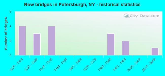
- New bridges - historical statistics
- 41920-1929
- 31930-1939
- 41940-1949
- 31980-1989
- 21990-1999
- 12010-2019

- Reconstructed bridges - Historical Statistics
- 21980-1989
- 11990-1999
- 22000-2009

- Bridge Condition - Deck
- 45.5%Good
- 36.4%Satisfactory
- 18.2%Fair

- Bridge Condition - Superstructure
- 14.3%Excellent
- 14.3%Good
- 35.7%Satisfactory
- 28.6%Fair
- 7.1%Poor

- Bridge Condition - Substructure
- 7.1%Excellent
- 7.1%Very good
- 14.3%Good
- 21.4%Satisfactory
- 42.9%Fair
- 7.1%Poor

- Bridge Condition - Channel
- 6.7%Very good
- 20.0%Good
- 20.0%Satisfactory
- 53.3%Fair
Find on map >> Show street view
Structure Number: 100025, Location: JCT OF RTS 2 & 22 (Lat: 42.751181, Lng: -73.345942), Route carried "on" structure: US 2, Year Built: 1931, Status: Open, Structure Length: 1.65m (5.41ft), Average Daily Traffic: 1,907 (year 2016), Truck Traffic: 7%, Average Future Daily Traffic: 2,033 (year 2040), Features Intersected: RTE 22
Minimum Vertical Clearance: 30+ m (98+ ft), Kilometerpoint: 33.725, Lanes on structure: 2, Lanes under structure: 2, Base Highway Network: Yes, Owner: State Highway Agency, Approaching Roadway Width: 8.5m (27.9ft), Skew: 2 degrees, Material/Design: Concrete, Design/Construction: Arch - Deck, Number Of Spans In Main Unit: 1, Length of Maximum Span: 12.1m (39.7ft), Curb-To-Curb Width: 8.4m (27.6ft), Out-to-Out Width: 11.3m (37.1ft)
Condition: Superstructure: Poor, Substructure: Fair, Operating Rating: 57.6 metric tons, Method Used To Determine Operating Rating: Field evaluation and documented engineering judgment, Inventory Rating: 15.1 metric tons, Method Used To Determine Inventory Rating: Field evaluation and documented engineering judgment, Structural Evaluation: Meets minimum limits, Deck Geometry: Meets minimum limits, Underclear: High priority of corrective action, Approach Roadway Alignment: Equal to present desirable criteria, Length Of Structure Improvement: 1.64m (5.38ft), Designated Inspection Frequency: Every 24 months, Inspection Date: May 2020, Bridge Improvement Cost: $760,000, Roadway Improvement Cost: $445,000, Total Project Cost: $1,204,000 ( Estimate for 2021), Wearing Surface/Protective System: Wearing Surface: Bituminous
Find on map >> Show street view
Structure Number: 100027, Location: IN PETERSBURG (Lat: 42.748933, Lng: -73.339269), Route carried "on" structure: State highway 2, Year Built: 1931, Year Reconstructed: 2005, Status: Open, Structure Length: 1.65m (5.41ft), Average Daily Traffic: 961 (year 2016), Truck Traffic: 5%, Average Future Daily Traffic: 1,024 (year 2040), Design Load: HS 25 or greater, Features Intersected: LITTLE HOOSIC RIVER
Minimum Vertical Clearance: 30+ m (98+ ft), Kilometerpoint: 34.320, Lanes on structure: 2, Base Highway Network: Yes, Owner: State Highway Agency, Approaching Roadway Width: 10.4m (34.1ft), Material/Design: Concrete, Design/Construction: Arch - Deck, Number Of Spans In Main Unit: 1, Length of Maximum Span: 15.8m (51.8ft), Curb-To-Curb Width: 10.5m (34.4ft), Out-to-Out Width: 11.2m (36.7ft)
Condition: Superstructure: Satisfactory, Substructure: Satisfactory, Channel: Good, Operating Rating: 83.8 metric tons, Method Used To Determine Operating Rating: Field evaluation and documented engineering judgment, Inventory Rating: 40.8 metric tons, Method Used To Determine Inventory Rating: Field evaluation and documented engineering judgment, Structural Evaluation: Equal to present minimum criteria, Deck Geometry: Equal to present minimum criteria, Waterway Adequacy: Somewhat better than minimum adequacy, Approach Roadway Alignment: Meets minimum limits, Length Of Structure Improvement: 1.64m (5.38ft), Designated Inspection Frequency: Every 24 months, Inspection Date: July 2020, Bridge Improvement Cost: $668,000, Roadway Improvement Cost: $391,000, Total Project Cost: $1,060,000 ( Estimate for 2021), Wearing Surface/Protective System: Wearing Surface: Bituminous
Find on map >> Show street view
Structure Number: 100028, Location: 1.6 MI E PETERSBURG (Lat: 42.744553, Lng: -73.310906), Route carried "on" structure: State highway 2, Year Built: 1926, Status: Open, Structure Length: 0.88m (2.89ft), Average Daily Traffic: 961 (year 2016), Truck Traffic: 5%, Average Future Daily Traffic: 1,024 (year 2040), Features Intersected: DAYFOOT BROOK
Minimum Vertical Clearance: 30+ m (98+ ft), Kilometerpoint: 36.894, Lanes on structure: 2, Base Highway Network: Yes, Owner: State Highway Agency, Approaching Roadway Width: 7.9m (25.9ft), Skew: 4 degrees, Material/Design: Concrete, Design/Construction: Culvert, Number Of Spans In Main Unit: 1, Length of Maximum Span: 8.5m (27.9ft)
Condition: Channel: Good, Culverts: Fair, Operating Rating: 47.7 metric tons, Method Used To Determine Operating Rating: Field evaluation and documented engineering judgment, Inventory Rating: 19.8 metric tons, Method Used To Determine Inventory Rating: Field evaluation and documented engineering judgment, Structural Evaluation: Somewhat better than minimum adequacy, Waterway Adequacy: Somewhat better than minimum adequacy, Approach Roadway Alignment: Meets minimum limits, Length Of Structure Improvement: 0.88m (2.89ft), Designated Inspection Frequency: Every 24 months, Inspection Date: May 2020, Bridge Improvement Cost: $124,000, Roadway Improvement Cost: $72,000, Total Project Cost: $196,000 ( Estimate for 2021), Wearing Surface/Protective System: Wearing Surface: Bituminous
Find on map >> Show street view
Structure Number: 101697, Location: 1.2 MI N JCT 22 & 2 (Lat: 42.769047, Lng: -73.342169), Route carried "on" structure: State highway 22, Year Built: 1945, Year Reconstructed: 2012, Status: Open, Structure Length: 1.19m (3.90ft), Average Daily Traffic: 2,321 (year 2016), Truck Traffic: 9%, Average Future Daily Traffic: 2,475 (year 2040), Features Intersected: DILL BROOK
Minimum Vertical Clearance: 30+ m (98+ ft), Kilometerpoint: 31.762, Lanes on structure: 2, Base Highway Network: Yes, Owner: State Highway Agency, Approaching Roadway Width: 11.0m (36.1ft), Material/Design: Steel, Design/Construction: Stringer/Multi-beam, Number Of Spans In Main Unit: 1, Length of Maximum Span: 11.5m (37.7ft), Curb-To-Curb Width: 10.9m (35.8ft), Out-to-Out Width: 12.4m (40.7ft)
Condition: Deck: Good, Superstructure: Fair, Substructure: Fair, Channel: Fair, Operating Rating: 81.6 metric tons, Method Used To Determine Operating Rating: Load and Resistance Factor Rating (LRFR) rating reported by rating factor(RF) method using HL-93 loadings, Inventory Rating: 62.9 metric tons, Method Used To Determine Inventory Rating: Load and Resistance Factor Rating (LRFR) rating reported by rating factor(RF) method using HL-93 loadings, Structural Evaluation: Somewhat better than minimum adequacy, Deck Geometry: Somewhat better than minimum adequacy, Waterway Adequacy: Meets minimum limits, Approach Roadway Alignment: Equal to present desirable criteria, Length Of Structure Improvement: 1.18m (3.87ft), Designated Inspection Frequency: Every 24 months, Inspection Date: June 2020, Bridge Improvement Cost: $614,000, Roadway Improvement Cost: $359,000, Total Project Cost: $973,000 ( Estimate for 2021), Deck Structure Type: Concrete Cast-file-Place, Wearing Surface/Protective System: Wearing Surface: Integral Concrete, Deck Protection: Epoxy Coated Reinforcing
Find on map >> Show street view
Structure Number: 104624, Location: 0.3 MI E JCT RTS 22 & 346 (Lat: 42.823008, Lng: -73.326642), Route carried "on" structure: State highway 346, Year Built: 1922, Year Reconstructed: 1999, Status: Open, Structure Length: 2.80m (9.19ft), Average Daily Traffic: 1,188 (year 2016), Truck Traffic: 11%, Average Future Daily Traffic: 1,239 (year 2040), Design Load: HS 25 or greater, Features Intersected: LITTLE HOOSIC RIV
Minimum Vertical Clearance: 30+ m (98+ ft), Kilometerpoint: 0.467, Lanes on structure: 2, Base Highway Network: Yes, Owner: State Highway Agency, Approaching Roadway Width: 7.3m (24.0ft), Material/Design: Prestressed concrete, Design/Construction: Box Beam or Girders - Multiple, Number Of Spans In Main Unit: 1, Length of Maximum Span: 27.1m (88.9ft), Curb-To-Curb Width: 7.3m (24.0ft), Out-to-Out Width: 7.9m (25.9ft)
Condition: Deck: Good, Superstructure: Excellent, Substructure: Fair, Channel: Satisfactory, Operating Rating: 89.8 metric tons, Method Used To Determine Operating Rating: Load Factor (LF), Inventory Rating: 45.4 metric tons, Method Used To Determine Inventory Rating: Load Factor (LF), Structural Evaluation: Somewhat better than minimum adequacy, Deck Geometry: Meets minimum limits, Waterway Adequacy: Meets minimum limits, Approach Roadway Alignment: Equal to present desirable criteria, Length Of Structure Improvement: 2.80m (9.19ft), Designated Inspection Frequency: Every 24 months, Inspection Date: May 2021, Bridge Improvement Cost: $778,000, Roadway Improvement Cost: $455,000, Total Project Cost: $1,233,000 ( Estimate for 2021), Deck Structure Type: Concrete Cast-file-Place, Wearing Surface/Protective System: Wearing Surface: Monolithic Concrete
Find on map >> Show street view
Structure Number: 107276, Location: JCT.RTE.346&HOOSIC RIVER (Lat: 42.809469, Lng: -73.286481), Route carried "on" structure: State highway 346, Year Built: 1983, Status: Open, Structure Length: 6.71m (22.01ft), Average Daily Traffic: 1,188 (year 2016), Truck Traffic: 11%, Average Future Daily Traffic: 1,239 (year 2040), Design Load: HS 20+Mod, Features Intersected: HOOSIC RIVER
Minimum Vertical Clearance: 30+ m (98+ ft), Kilometerpoint: 4.167, Lanes on structure: 2, Base Highway Network: Yes, Owner: State Highway Agency, Approaching Roadway Width: 12.2m (40.0ft), Skew: 2 degrees, Material/Design: Steel continuous, Design/Construction: Stringer/Multi-beam, Number Of Spans In Main Unit: 2, Length of Maximum Span: 33.2m (108.9ft), Curb-To-Curb Width: 11.8m (38.7ft), Out-to-Out Width: 13.0m (42.7ft)
Condition: Deck: Good, Superstructure: Good, Substructure: Good, Channel: Fair, Inventory Rating: 63.5 metric tons, Method Used To Determine Inventory Rating: Load Factor (LF), Structural Evaluation: Better than present minimum criteria, Deck Geometry: Equal to present minimum criteria, Waterway Adequacy: Somewhat better than minimum adequacy, Approach Roadway Alignment: Equal to present desirable criteria, Length Of Structure Improvement: 6.70m (21.98ft), Designated Inspection Frequency: Every 24 months, Inspection Date: June 2020, Bridge Improvement Cost: $1,981,000, Roadway Improvement Cost: $1,160,000, Total Project Cost: $3,141,000 ( Estimate for 2021), Deck Structure Type: Concrete Cast-file-Place, Wearing Surface/Protective System: Wearing Surface: Bituminous, Membrane: Preformed Fabric
Find on map >> Show street view
Structure Number: 220168, Location: 1.0 MI NE PETERSBURG (Lat: 42.763819, Lng: -73.337256), Route carried "on" structure: Other road , Year Built: 1948, Status: Open, Structure Length: 2.01m (6.59ft), Average Daily Traffic: 69 (year 2018), Truck Traffic: 9%, Average Future Daily Traffic: 97 (year 2038), Features Intersected: LITTLE HOOSIC RIVER, Facility Carried by Structure: LEWIS HOLLOW RD
Minimum Vertical Clearance: 30+ m (98+ ft), Kilometerpoint: 0.241, Lanes on structure: 2, Owner: Town or Township Highway Agency, Approaching Roadway Width: 5.5m (18.0ft), Material/Design: Steel, Design/Construction: Stringer/Multi-beam, Number Of Spans In Main Unit: 1, Length of Maximum Span: 19.2m (63.0ft), Curb-To-Curb Width: 5.8m (19.0ft), Out-to-Out Width: 6.1m (20.0ft)
Condition: Deck: Fair, Superstructure: Fair, Substructure: Fair, Channel: Satisfactory, Operating Rating: 15.6 metric tons, Method Used To Determine Operating Rating: Load and Resistance Factor Rating (LRFR) rating reported by rating factor(RF) method using HL-93 loadings, Inventory Rating: 12.0 metric tons, Method Used To Determine Inventory Rating: Load and Resistance Factor Rating (LRFR) rating reported by rating factor(RF) method using HL-93 loadings, Structural Evaluation: Meets minimum limits, Deck Geometry: Meets minimum limits, Waterway Adequacy: Meets minimum limits, Approach Roadway Alignment: Meets minimum limits, Length Of Structure Improvement: 2.01m (6.59ft), Designated Inspection Frequency: Every 24 months, Inspection Date: May 2020, Bridge Improvement Cost: $402,000, Roadway Improvement Cost: $236,000, Total Project Cost: $638,000 ( Estimate for 2021), Deck Structure Type: Open Grating, Wearing Surface/Protective System: Wearing Surface: Other
Find on map >> Show street view
Structure Number: 220171, Location: 2.1MI.N.PETERSBURG (Lat: 42.781111, Lng: -73.335692), Route carried "on" structure: Other road , Year Built: 1947, Year Reconstructed: 1989, Status: Open, Structure Length: 1.77m (5.81ft), Average Daily Traffic: 21 (year 2018), Truck Traffic: 11%, Average Future Daily Traffic: 29 (year 2038), Design Load: HS 20, Features Intersected: LITTLE HOOSIC RIV, Facility Carried by Structure: PROSSER HOLLOW RD
Minimum Vertical Clearance: 30+ m (98+ ft), Kilometerpoint: 0.193, Lanes on structure: 2, Owner: Town or Township Highway Agency, Approaching Roadway Width: 6.7m (22.0ft), Material/Design: Steel, Design/Construction: Stringer/Multi-beam, Number Of Spans In Main Unit: 1, Length of Maximum Span: 17.0m (55.8ft), Curb-To-Curb Width: 6.7m (22.0ft), Out-to-Out Width: 7.3m (24.0ft)
Condition: Deck: Good, Superstructure: Fair, Substructure: Fair, Channel: Fair, Operating Rating: 45.4 metric tons, Method Used To Determine Operating Rating: Load Factor (LF), Inventory Rating: 27.2 metric tons, Method Used To Determine Inventory Rating: Load Factor (LF), Structural Evaluation: Somewhat better than minimum adequacy, Deck Geometry: Somewhat better than minimum adequacy, Waterway Adequacy: Somewhat better than minimum adequacy, Approach Roadway Alignment: High priority of corrective action, Length Of Structure Improvement: 1.76m (5.77ft), Designated Inspection Frequency: Every 24 months, Inspection Date: May 2020, Bridge Improvement Cost: $502,000, Roadway Improvement Cost: $294,000, Total Project Cost: $796,000 ( Estimate for 2021), Deck Structure Type: Wood or Timber, Wearing Surface/Protective System: Wearing Surface: Bituminous
Find on map >> Show street view
Structure Number: 220172, Location: 4.6 MI N PETERSBURG (Lat: 42.810650, Lng: -73.333558), Route carried "on" structure: Other road , Year Built: 1948, Status: Open, Structure Length: 1.92m (6.30ft), Average Daily Traffic: 38 (year 2018), Truck Traffic: 6%, Average Future Daily Traffic: 53 (year 2038), Features Intersected: LITTLE HOOSIC RIVER, Facility Carried by Structure: WEBSTER ROAD
Minimum Vertical Clearance: 30+ m (98+ ft), Kilometerpoint: 0.113, Lanes on structure: 1, Owner: Town or Township Highway Agency, Approaching Roadway Width: 3.4m (11.2ft), Material/Design: Steel, Design/Construction: Stringer/Multi-beam, Number Of Spans In Main Unit: 2, Length of Maximum Span: 9.4m (30.8ft), Curb-To-Curb Width: 3.3m (10.8ft), Out-to-Out Width: 3.7m (12.1ft)
Condition: Deck: Satisfactory, Superstructure: Satisfactory, Substructure: Satisfactory, Channel: Fair, Operating Rating: 83.5 metric tons, Method Used To Determine Operating Rating: Load Factor (LF), Inventory Rating: 49.9 metric tons, Method Used To Determine Inventory Rating: Load Factor (LF), Structural Evaluation: Equal to present minimum criteria, Deck Geometry: High priority of replacement, Waterway Adequacy: Equal to present desirable criteria, Approach Roadway Alignment: Meets minimum limits, Length Of Structure Improvement: 1.92m (6.30ft), Designated Inspection Frequency: Every 24 months, Inspection Date: May 2020, Bridge Improvement Cost: $194,000, Roadway Improvement Cost: $113,000, Total Project Cost: $307,000 ( Estimate for 2021), Deck Structure Type: Concrete Cast-file-Place, Wearing Surface/Protective System: Wearing Surface: Monolithic Concrete
Find on map >> Show street view
Structure Number: 220173, Location: 1.6 MI. SW OF PETERSBURG (Lat: 42.731456, Lng: -73.362056), Route carried "on" structure: County highway , Year Built: 1985, Status: Open, Structure Length: 1.10m (3.61ft), Average Daily Traffic: 15 (year 2018), Average Future Daily Traffic: 21 (year 2038), Design Load: HS 20, Features Intersected: LITTLE HOOSIC RIV, Facility Carried by Structure: BRIMMER BRIDGE RD
Minimum Vertical Clearance: 30+ m (98+ ft), Kilometerpoint: 0.016, Lanes on structure: 2, Owner: Town or Township Highway Agency, Approaching Roadway Width: 6.1m (20.0ft), Material/Design: Prestressed concrete, Design/Construction: Box Beam or Girders - Multiple, Number Of Spans In Main Unit: 1, Length of Maximum Span: 10.3m (33.8ft), Curb-To-Curb Width: 6.1m (20.0ft), Out-to-Out Width: 6.8m (22.3ft)
Condition: Deck: Satisfactory, Superstructure: Satisfactory, Substructure: Very good, Channel: Good, Operating Rating: 66.2 metric tons, Method Used To Determine Operating Rating: Load Factor (LF), Inventory Rating: 39.9 metric tons, Method Used To Determine Inventory Rating: Load Factor (LF), Structural Evaluation: Equal to present minimum criteria, Deck Geometry: Somewhat better than minimum adequacy, Waterway Adequacy: Somewhat better than minimum adequacy, Approach Roadway Alignment: Equal to present desirable criteria, Length Of Structure Improvement: 1.09m (3.58ft), Designated Inspection Frequency: Every 24 months, Inspection Date: April 2020, Bridge Improvement Cost: $362,000, Roadway Improvement Cost: $212,000, Total Project Cost: $574,000 ( Estimate for 2021), Wearing Surface/Protective System: Wearing Surface: Bituminous
Find on map >> Show street view
Structure Number: 220174, Location: 2.2 MILES NORTH OF BERLIN (Lat: 42.725583, Lng: -73.366525), Route carried "on" structure: Other road , Year Built: 2016, Status: Open, Structure Length: 1.77m (5.81ft), Average Daily Traffic: 56 (year 2014), Average Future Daily Traffic: 78 (year 2034), Features Intersected: LITT HOOSIC RIVER, Facility Carried by Structure: BROKEN WHEEL ROAD
Minimum Vertical Clearance: 30+ m (98+ ft), Kilometerpoint: 0.016, Lanes on structure: 2, Owner: Town or Township Highway Agency, Approaching Roadway Width: 6.7m (22.0ft), Material/Design: Concrete, Design/Construction: Frame, Number Of Spans In Main Unit: 1, Length of Maximum Span: 17.4m (57.1ft), Curb-To-Curb Width: 6.6m (21.7ft), Out-to-Out Width: 7.9m (25.9ft)
Condition: Superstructure: Excellent, Substructure: Excellent, Channel: Very good, Operating Rating: 23.6 metric tons, Method Used To Determine Operating Rating: Load Factor (LF), Inventory Rating: 17.2 metric tons, Method Used To Determine Inventory Rating: Load Factor (LF), Structural Evaluation: Somewhat better than minimum adequacy, Deck Geometry: Somewhat better than minimum adequacy, Waterway Adequacy: Equal to present desirable criteria, Approach Roadway Alignment: Meets minimum limits, Length Of Structure Improvement: 1.76m (5.77ft), Designated Inspection Frequency: Every 24 months, Inspection Date: November 2020, Bridge Improvement Cost: $286,000, Roadway Improvement Cost: $167,000, Total Project Cost: $453,000 ( Estimate for 2021)
Find on map >> Show street view
Structure Number: 220176, Location: 1.7 MI E OF PETERSBURG (Lat: 42.743689, Lng: -73.317839), Route carried "on" structure: Other road , Year Built: 1988, Status: Open, Structure Length: 0.79m (2.59ft), Average Daily Traffic: 37 (year 2018), Truck Traffic: 6%, Average Future Daily Traffic: 52 (year 2038), Features Intersected: DAYFOOT BROOK, Facility Carried by Structure: BABCOCK ROAD
Minimum Vertical Clearance: 30+ m (98+ ft), Kilometerpoint: 0.032, Lanes on structure: 2, Owner: Town or Township Highway Agency, Approaching Roadway Width: 7.3m (24.0ft), Material/Design: Steel, Design/Construction: Culvert, Number Of Spans In Main Unit: 1, Length of Maximum Span: 7.6m (24.9ft)
Condition: Channel: Fair, Culverts: Fair, Operating Rating: 77.5 metric tons, Method Used To Determine Operating Rating: Field evaluation and documented engineering judgment, Inventory Rating: 29.4 metric tons, Method Used To Determine Inventory Rating: Field evaluation and documented engineering judgment, Structural Evaluation: Somewhat better than minimum adequacy, Waterway Adequacy: Meets minimum limits, Approach Roadway Alignment: Better than present minimum criteria, Length Of Structure Improvement: 0.79m (2.59ft), Designated Inspection Frequency: Every 24 months, Inspection Date: May 2021, Bridge Improvement Cost: $67,000, Roadway Improvement Cost: $39,000, Total Project Cost: $106,000 ( Estimate for 2021)
Find on map >> Show street view
Structure Number: 220186, Location: 0.8MI.E.PETERSBURG (Lat: 42.749464, Lng: -73.332972), Route carried "on" structure: Other road , Year Built: 1927, Status: Open, Structure Length: 1.10m (3.61ft), Average Daily Traffic: 36 (year 2020), Truck Traffic: 6%, Average Future Daily Traffic: 50 (year 2040), Features Intersected: DAYFOOT BROOK, Facility Carried by Structure: DAYFOOT RD
Minimum Vertical Clearance: 30+ m (98+ ft), Kilometerpoint: 0.274, Lanes on structure: 2, Owner: County Highway Agency, Approaching Roadway Width: 5.2m (17.1ft), Skew: 1 degrees, Material/Design: Steel, Design/Construction: Stringer/Multi-beam, Number Of Spans In Main Unit: 1, Length of Maximum Span: 10.3m (33.8ft), Curb-To-Curb Width: 5.0m (16.4ft), Out-to-Out Width: 5.7m (18.7ft)
Condition: Deck: Fair, Superstructure: Fair, Substructure: Poor, Channel: Fair, Operating Rating: 38.9 metric tons, Method Used To Determine Operating Rating: Load and Resistance Factor Rating (LRFR) rating reported by rating factor(RF) method using HL-93 loadings, Inventory Rating: 29.8 metric tons, Method Used To Determine Inventory Rating: Load and Resistance Factor Rating (LRFR) rating reported by rating factor(RF) method using HL-93 loadings, Structural Evaluation: Meets minimum limits, Deck Geometry: High priority of corrective action, Waterway Adequacy: Equal to present desirable criteria, Approach Roadway Alignment: Equal to present minimum criteria, Length Of Structure Improvement: 1.09m (3.58ft), Designated Inspection Frequency: Every 24 months, Inspection Date: April 2020, Bridge Improvement Cost: $217,000, Roadway Improvement Cost: $127,000, Total Project Cost: $344,000 ( Estimate for 2021), Deck Structure Type: Concrete Cast-file-Place, Wearing Surface/Protective System: Wearing Surface: Bituminous
Find on map >> Show street view
Structure Number: 330369, Location: 0.5 MI S OF PETERSBURG (Lat: 42.743989, Lng: -73.348556), Route carried "on" structure: County highway , Year Built: 1923, Year Reconstructed: 1988, Status: Open, Structure Length: 1.55m (5.09ft), Average Daily Traffic: 167 (year 2020), Truck Traffic: 6%, Average Future Daily Traffic: 234 (year 2040), Design Load: HS 20, Features Intersected: LITTLE HOOSIC RIV, Facility Carried by Structure: RIVER ROAD
Minimum Vertical Clearance: 30+ m (98+ ft), Kilometerpoint: 0.129, Lanes on structure: 2, Owner: County Highway Agency, Approaching Roadway Width: 7.0m (23.0ft), Material/Design: Steel, Design/Construction: Stringer/Multi-beam, Number Of Spans In Main Unit: 1, Length of Maximum Span: 14.9m (48.9ft), Curb-To-Curb Width: 7.2m (23.6ft), Out-to-Out Width: 8.6m (28.2ft)
Condition: Deck: Satisfactory, Superstructure: Satisfactory, Substructure: Fair, Channel: Fair, Operating Rating: 52.6 metric tons, Method Used To Determine Operating Rating: Load Factor (LF), Inventory Rating: 33.6 metric tons, Method Used To Determine Inventory Rating: Load Factor (LF), Structural Evaluation: Somewhat better than minimum adequacy, Deck Geometry: Meets minimum limits, Waterway Adequacy: Meets minimum limits, Approach Roadway Alignment: Equal to present minimum criteria, Length Of Structure Improvement: 1.55m (5.09ft), Designated Inspection Frequency: Every 24 months, Inspection Date: June 2020, Bridge Improvement Cost: $395,000, Roadway Improvement Cost: $231,000, Total Project Cost: $626,000 ( Estimate for 2021), Deck Structure Type: Wood or Timber, Wearing Surface/Protective System: Wearing Surface: Bituminous
Find on map >> Show street view
Structure Number: 33037, Location: IN PETERSBURG (Lat: 42.750450, Lng: -73.336550), Route carried "on" structure: County highway , Year Built: 1991, Status: Open, Structure Length: 2.29m (7.51ft), Average Daily Traffic: 147 (year 2020), Truck Traffic: 6%, Average Future Daily Traffic: 206 (year 2040), Design Load: HS 20, Features Intersected: LITTLE HOOSIC RIV, Facility Carried by Structure: HILLS HOLLOW RO
Minimum Vertical Clearance: 30+ m (98+ ft), Kilometerpoint: 0.306, Lanes on structure: 2, Owner: County Highway Agency, Approaching Roadway Width: 6.7m (22.0ft), Material/Design: Steel, Design/Construction: Stringer/Multi-beam, Number Of Spans In Main Unit: 1, Length of Maximum Span: 21.6m (70.9ft), Curb-To-Curb Width: 6.8m (22.3ft), Out-to-Out Width: 7.4m (24.3ft)
Condition: Deck: Good, Superstructure: Satisfactory, Substructure: Satisfactory, Channel: Satisfactory, Operating Rating: 66.2 metric tons, Method Used To Determine Operating Rating: Load Factor (LF), Inventory Rating: 41.7 metric tons, Method Used To Determine Inventory Rating: Load Factor (LF), Structural Evaluation: Equal to present minimum criteria, Deck Geometry: Meets minimum limits, Waterway Adequacy: Somewhat better than minimum adequacy, Approach Roadway Alignment: Equal to present minimum criteria, Length Of Structure Improvement: 2.28m (7.48ft), Designated Inspection Frequency: Every 24 months, Inspection Date: July 2020, Bridge Improvement Cost: $539,000, Roadway Improvement Cost: $315,000, Total Project Cost: $854,000 ( Estimate for 2021), Deck Structure Type: Other, Wearing Surface/Protective System: Wearing Surface: Integral Concrete
Find on map >> Show street view
Structure Number: 330372, Location: .6 MI NE OF N PETERSBURG (Lat: 42.826528, Lng: -73.322058), Route carried "on" structure: County highway , Year Built: 1990, Status: Open, Structure Length: 4.82m (15.81ft), Average Daily Traffic: 548 (year 2016), Truck Traffic: 7%, Average Future Daily Traffic: 767 (year 2036), Design Load: HS 20, Features Intersected: HOOSIC RIVER, Facility Carried by Structure: COUNTY ROAD 95
Minimum Vertical Clearance: 30+ m (98+ ft), Kilometerpoint: 0.032, Lanes on structure: 2, Owner: County Highway Agency, Approaching Roadway Width: 9.1m (29.9ft), Material/Design: Prestressed concrete continuous, Design/Construction: Box Beam or Girders - Multiple, Number Of Spans In Main Unit: 2, Length of Maximum Span: 22.8m (74.8ft), Curb-To-Curb Width: 9.3m (30.5ft), Out-to-Out Width: 9.8m (32.2ft)
Condition: Deck: Satisfactory, Superstructure: Good, Substructure: Good, Channel: Fair, Operating Rating: 76.2 metric tons, Method Used To Determine Operating Rating: Load Factor (LF), Inventory Rating: 37.2 metric tons, Method Used To Determine Inventory Rating: Load Factor (LF), Structural Evaluation: Better than present minimum criteria, Deck Geometry: Equal to present minimum criteria, Waterway Adequacy: Equal to present minimum criteria, Approach Roadway Alignment: Equal to present desirable criteria, Length Of Structure Improvement: 4.81m (15.78ft), Designated Inspection Frequency: Every 24 months, Inspection Date: June 2020, Bridge Improvement Cost: $1,810,000, Roadway Improvement Cost: $1,060,000, Total Project Cost: $2,870,000 ( Estimate for 2021), Deck Structure Type: Concrete Cast-file-Place, Wearing Surface/Protective System: Wearing Surface: Monolithic Concrete
Find on map >> Show street view
Structure Number: 100025, Location: JCT OF RTS 2 & 22 (Lat: 42.751181, Lng: -73.345942), Route carried "under" structure: State highway 22, Year Built: 1931, Structure Length: 0. m, Average Daily Traffic: 2,784 (year 1999), Features Intersected: RTE 22, Facility Carried by Structure: RTE 2
Minimum Vertical Clearance: 4.52m (14.83ft), Kilometerpoint: 30.185, Lanes on structure: 2, Lanes under structure: 2, Material/Design: Concrete, Design/Construction: Arch - Deck, Length of Maximum Span: 12.1m (39.7ft)