Bridge Statistics for Pamelia, New York (NY)
Condition, Traffic, Stress, Structural Evaluation, Project Costs
- National Bridge Inventory (NBI) Statistics
- 33Number of bridges
- 302ft / 92.1mTotal length
- $36,384,000Total costs
- 161,935Total average daily traffic
- 15,488Total average daily truck traffic
- National Bridge Inventory (NBI) Registered Bridges for Pamelia
- No street view available for this location
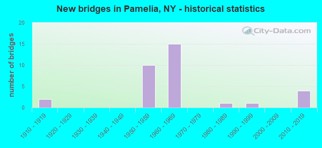
- New bridges - historical statistics
- 21910-1919
- 101950-1959
- 151960-1969
- 11980-1989
- 11990-1999
- 42010-2019


- Bridge Condition - Deck
- 6.7%Excellent
- 13.3%Very good
- 33.3%Good
- 33.3%Satisfactory
- 13.3%Fair

- Bridge Condition - Superstructure
- 13.3%Excellent
- 20.0%Good
- 53.3%Satisfactory
- 13.3%Fair

- Bridge Condition - Substructure
- 13.3%Excellent
- 6.7%Good
- 40.0%Satisfactory
- 20.0%Fair
- 20.0%Poor

- Bridge Condition - Channel
- 14.3%Very good
- 71.4%Good
- 14.3%Satisfactory

- Bridge Condition - Culverts
- 50.0%Good
- 50.0%Satisfactory
Find on map >> Show street view
Structure Number: 1009681, Location: JCT I-81 & NYS 12 (Lat: 44.001119, Lng: -75.919822), Route carried "on" structure: Interstate 81, Year Built: 1959, Year Reconstructed: 2003, Status: Open, Structure Length: 4.54m (14.90ft), Average Daily Traffic: 12,167 (year 2009), Truck Traffic: 16%, Design Load: HS 20, Features Intersected: RTE 12
Minimum Vertical Clearance: 30+ m (98+ ft), Kilometerpoint: 40.161, Lanes on structure: 2, Lanes under structure: 2, Base Highway Network: Yes, Owner: State Highway Agency, Approaching Roadway Width: 11.6m (38.1ft), Material/Design: Steel, Design/Construction: Stringer/Multi-beam, Number Of Spans In Main Unit: 3, Length of Maximum Span: 20.1m (65.9ft), Curb-To-Curb Width: 11.7m (38.4ft), Out-to-Out Width: 12.7m (41.7ft)
Condition: Deck: Good, Superstructure: Satisfactory, Substructure: Fair, Operating Rating: 68.0 metric tons, Method Used To Determine Operating Rating: Load Factor (LF), Inventory Rating: 40.8 metric tons, Method Used To Determine Inventory Rating: Load Factor (LF), Structural Evaluation: Somewhat better than minimum adequacy, Deck Geometry: Equal to present minimum criteria, Underclear: Meets minimum limits, Approach Roadway Alignment: Equal to present desirable criteria, Length Of Structure Improvement: 4.54m (14.90ft), Designated Inspection Frequency: Every 24 months, Inspection Date: September 2021, Bridge Improvement Cost: $1,177,000, Roadway Improvement Cost: $689,000, Total Project Cost: $1,865,000 ( Estimate for 2021), Deck Structure Type: Concrete Cast-file-Place, Wearing Surface/Protective System: Wearing Surface: Integral Concrete, Deck Protection: Epoxy Coated Reinforcing
Find on map >> Show street view
Structure Number: 1009682, Location: JCT I-81 & NYS 12 (Lat: 44.000958, Lng: -75.919731), Route carried "on" structure: Interstate 81, Year Built: 1959, Year Reconstructed: 2003, Status: Open, Structure Length: 4.54m (14.90ft), Average Daily Traffic: 10,843 (year 2019), Truck Traffic: 14%, Average Future Daily Traffic: 14,150 (year 2040), Design Load: HS 20, Features Intersected: RTE 12
Minimum Vertical Clearance: 30+ m (98+ ft), Kilometerpoint: 40.161, Lanes on structure: 2, Lanes under structure: 2, Base Highway Network: Yes, Owner: State Highway Agency, Approaching Roadway Width: 11.6m (38.1ft), Material/Design: Steel, Design/Construction: Stringer/Multi-beam, Number Of Spans In Main Unit: 3, Length of Maximum Span: 20.1m (65.9ft), Curb-To-Curb Width: 11.7m (38.4ft), Out-to-Out Width: 12.7m (41.7ft)
Condition: Deck: Good, Superstructure: Satisfactory, Substructure: Satisfactory, Operating Rating: 61.7 metric tons, Method Used To Determine Operating Rating: Load Factor (LF), Inventory Rating: 37.2 metric tons, Method Used To Determine Inventory Rating: Load Factor (LF), Structural Evaluation: Equal to present minimum criteria, Deck Geometry: Equal to present minimum criteria, Underclear: Meets minimum limits, Approach Roadway Alignment: Equal to present desirable criteria, Length Of Structure Improvement: 4.54m (14.90ft), Designated Inspection Frequency: Every 24 months, Inspection Date: September 2021, Bridge Improvement Cost: $1,177,000, Roadway Improvement Cost: $689,000, Total Project Cost: $1,865,000 ( Estimate for 2021), Deck Structure Type: Concrete Cast-file-Place, Wearing Surface/Protective System: Wearing Surface: Integral Concrete, Deck Protection: Epoxy Coated Reinforcing
Find on map >> Show street view
Structure Number: 100969, Location: .6 MT N JCT RTE 12&I81 (Lat: 44.009561, Lng: -75.924569), Route carried "on" structure: State highway 12, Year Built: 1985, Status: Open, Structure Length: 1.83m (6.00ft), Average Daily Traffic: 5,369 (year 2017), Truck Traffic: 7%, Average Future Daily Traffic: 6,522 (year 2040), Design Load: HS 20, Features Intersected: PHILOMEL CREEK
Minimum Vertical Clearance: 30+ m (98+ ft), Kilometerpoint: 24.811, Lanes on structure: 2, Base Highway Network: Yes, Owner: State Highway Agency, Approaching Roadway Width: 12.2m (40.0ft), Material/Design: Prestressed concrete, Design/Construction: Box Beam or Girders - Multiple, Number Of Spans In Main Unit: 1, Length of Maximum Span: 16.7m (54.8ft), Curb-To-Curb Width: 12.2m (40.0ft), Out-to-Out Width: 12.9m (42.3ft)
Condition: Deck: Satisfactory, Superstructure: Satisfactory, Substructure: Satisfactory, Channel: Very good, Operating Rating: 59.9 metric tons, Method Used To Determine Operating Rating: Load Factor (LF), Inventory Rating: 34.5 metric tons, Method Used To Determine Inventory Rating: Load Factor (LF), Structural Evaluation: Equal to present minimum criteria, Deck Geometry: Somewhat better than minimum adequacy, Waterway Adequacy: Equal to present minimum criteria, Approach Roadway Alignment: Equal to present desirable criteria, Length Of Structure Improvement: 1.82m (5.97ft), Designated Inspection Frequency: Every 24 months, Inspection Date: August 2021, Bridge Improvement Cost: $363,000, Roadway Improvement Cost: $212,000, Total Project Cost: $575,000 ( Estimate for 2021), Deck Structure Type: Concrete Cast-file-Place, Wearing Surface/Protective System: Wearing Surface: Bituminous, Membrane: Other
Find on map >> Show street view
Structure Number: 1010081, Location: JCT RTS 12E + I-81 SB (Lat: 43.996744, Lng: -75.931953), Route carried "on" structure: Interstate 81, Year Built: 1959, Status: Open, Structure Length: 6.46m (21.19ft), Average Daily Traffic: 12,167 (year 2009), Truck Traffic: 16%, Design Load: HS 25 or greater, Features Intersected: RTE 12E
Minimum Vertical Clearance: 30+ m (98+ ft), Kilometerpoint: 39.050, Lanes on structure: 2, Lanes under structure: 2, Base Highway Network: Yes, Owner: State Highway Agency, Approaching Roadway Width: 10.4m (34.1ft), Material/Design: Steel, Design/Construction: Stringer/Multi-beam, Number Of Spans In Main Unit: 3, Length of Maximum Span: 23.5m (77.1ft), Curb-To-Curb Width: 10.2m (33.5ft), Out-to-Out Width: 11.2m (36.7ft)
Condition: Deck: Good, Superstructure: Good, Substructure: Satisfactory, Operating Rating: 65.3 metric tons, Method Used To Determine Operating Rating: Load Factor (LF), Inventory Rating: 48.1 metric tons, Method Used To Determine Inventory Rating: Load Factor (LF), Structural Evaluation: Equal to present minimum criteria, Deck Geometry: Meets minimum limits, Underclear: Somewhat better than minimum adequacy, Approach Roadway Alignment: Equal to present desirable criteria, Length Of Structure Improvement: 6.46m (21.19ft), Designated Inspection Frequency: Every 24 months, Inspection Date: September 2021, Bridge Improvement Cost: $1,373,000, Roadway Improvement Cost: $804,000, Total Project Cost: $2,177,000 ( Estimate for 2021), Deck Structure Type: Concrete Cast-file-Place, Wearing Surface/Protective System: Wearing Surface: Integral Concrete, Deck Protection: Epoxy Coated Reinforcing
Find on map >> Show street view
Structure Number: 1010082, Location: JCT RTS 12E + I-81 NB (Lat: 43.996589, Lng: -75.931797), Route carried "on" structure: Interstate 81, Year Built: 1959, Status: Open, Structure Length: 6.46m (21.19ft), Average Daily Traffic: 10,843 (year 2019), Truck Traffic: 14%, Average Future Daily Traffic: 14,150 (year 2040), Design Load: HS 25 or greater, Features Intersected: RTE 12E
Minimum Vertical Clearance: 30+ m (98+ ft), Kilometerpoint: 39.050, Lanes on structure: 2, Lanes under structure: 2, Base Highway Network: Yes, Owner: State Highway Agency, Approaching Roadway Width: 11.6m (38.1ft), Material/Design: Steel, Design/Construction: Stringer/Multi-beam, Number Of Spans In Main Unit: 3, Length of Maximum Span: 23.5m (77.1ft), Curb-To-Curb Width: 11.7m (38.4ft), Out-to-Out Width: 12.7m (41.7ft)
Condition: Deck: Good, Superstructure: Good, Substructure: Satisfactory, Operating Rating: 66.2 metric tons, Method Used To Determine Operating Rating: Load Factor (LF), Inventory Rating: 49.0 metric tons, Method Used To Determine Inventory Rating: Load Factor (LF), Structural Evaluation: Equal to present minimum criteria, Deck Geometry: Equal to present minimum criteria, Underclear: Somewhat better than minimum adequacy, Approach Roadway Alignment: Equal to present desirable criteria, Length Of Structure Improvement: 6.46m (21.19ft), Designated Inspection Frequency: Every 24 months, Inspection Date: September 2021, Bridge Improvement Cost: $1,586,000, Roadway Improvement Cost: $929,000, Total Project Cost: $2,515,000 ( Estimate for 2021), Deck Structure Type: Concrete Cast-file-Place, Wearing Surface/Protective System: Wearing Surface: Integral Concrete, Deck Protection: Epoxy Coated Reinforcing
Find on map >> Show street view
Structure Number: 102378, Location: 0.3 MI N JCT RTS 11 & 37 (Lat: 44.005717, Lng: -75.901872), Route carried "on" structure: State highway 37, Year Built: 1993, Status: Open, Structure Length: 1.25m (4.10ft), Average Daily Traffic: 2,908 (year 2018), Truck Traffic: 6%, Average Future Daily Traffic: 3,532 (year 2040), Design Load: HS 20, Features Intersected: KELSEY CREEK
Minimum Vertical Clearance: 30+ m (98+ ft), Kilometerpoint: 0.483, Lanes on structure: 2, Base Highway Network: Yes, Owner: State Highway Agency, Approaching Roadway Width: 10.4m (34.1ft), Skew: 3 degrees, Material/Design: Prestressed concrete, Design/Construction: Box Beam or Girders - Multiple, Number Of Spans In Main Unit: 1, Length of Maximum Span: 10.9m (35.8ft), Curb-To-Curb Width: 10.4m (34.1ft), Out-to-Out Width: 11.3m (37.1ft)
Condition: Deck: Very good, Superstructure: Satisfactory, Substructure: Good, Channel: Satisfactory, Operating Rating: 81.6 metric tons, Method Used To Determine Operating Rating: Load Factor (LF), Inventory Rating: 32.7 metric tons, Method Used To Determine Inventory Rating: Load Factor (LF), Structural Evaluation: Equal to present minimum criteria, Deck Geometry: Somewhat better than minimum adequacy, Waterway Adequacy: Somewhat better than minimum adequacy, Approach Roadway Alignment: Equal to present minimum criteria, Length Of Structure Improvement: 1.24m (4.07ft), Designated Inspection Frequency: Every 24 months, Inspection Date: September 2021, Bridge Improvement Cost: $395,000, Roadway Improvement Cost: $231,000, Total Project Cost: $627,000 ( Estimate for 2021), Deck Structure Type: Concrete Cast-file-Place, Wearing Surface/Protective System: Wearing Surface: Bituminous, Deck Protection: Epoxy Coated Reinforcing
Find on map >> Show street view
Structure Number: 103223, Location: 3.6 MI N JCT I-81 + 342 (Lat: 44.087856, Lng: -75.915022), Route carried "on" structure: County highway , Year Built: 1965, Status: Open, Structure Length: 9.05m (29.69ft), Average Daily Traffic: 811 (year 2020), Truck Traffic: 7%, Average Future Daily Traffic: 1,135 (year 2040), Design Load: HS 20, Features Intersected: RTE I81, RTE I81, Facility Carried by Structure: COUNTY ROAD 16
Minimum Vertical Clearance: 30+ m (98+ ft), Kilometerpoint: 4.570, Lanes on structure: 2, Lanes under structure: 4, Owner: State Highway Agency, Approaching Roadway Width: 6.7m (22.0ft), Skew: 2 degrees, Material/Design: Steel, Design/Construction: Stringer/Multi-beam, Number Of Spans In Main Unit: 5, Length of Maximum Span: 19.5m (64.0ft), Curb or Sidewalk Widths: Left: 0.5m (1.6ft), Right: 0.5m (1.6ft), Curb-To-Curb Width: 9.1m (29.9ft), Out-to-Out Width: 10.7m (35.1ft)
Condition: Deck: Fair, Superstructure: Satisfactory, Substructure: Satisfactory, Operating Rating: 54.4 metric tons, Method Used To Determine Operating Rating: Load Factor (LF), Inventory Rating: 32.7 metric tons, Method Used To Determine Inventory Rating: Load Factor (LF), Structural Evaluation: Equal to present minimum criteria, Deck Geometry: Equal to present minimum criteria, Underclear: High priority of corrective action, Approach Roadway Alignment: Equal to present desirable criteria, Length Of Structure Improvement: 9.05m (29.69ft), Designated Inspection Frequency: Every 24 months, Inspection Date: October 2020, Bridge Improvement Cost: $1,766,000, Roadway Improvement Cost: $1,034,000, Total Project Cost: $2,800,000 ( Estimate for 2021), Deck Structure Type: Concrete Cast-file-Place, Wearing Surface/Protective System: Wearing Surface: Bituminous, Membrane: Other
Find on map >> Show street view
Structure Number: 1032241, Location: 3.7 MI S JCT I-81 + 411 (Lat: 44.137231, Lng: -75.882136), Route carried "on" structure: Interstate 81, Year Built: 1965, Status: Open, Structure Length: 3.99m (13.09ft), Average Daily Traffic: 4,824 (year 2014), Truck Traffic: 22%, Design Load: HS 20, Features Intersected: COUNTY ROAD 15
Minimum Vertical Clearance: 30+ m (98+ ft), Kilometerpoint: 56.669, Lanes on structure: 2, Lanes under structure: 2, Base Highway Network: Yes, Owner: State Highway Agency, Approaching Roadway Width: 10.4m (34.1ft), Skew: 1 degrees, Material/Design: Steel, Design/Construction: Stringer/Multi-beam, Number Of Spans In Main Unit: 3, Length of Maximum Span: 14.9m (48.9ft), Curb or Sidewalk Widths: Left: 0.4m (1.3ft), Right: 0.4m (1.3ft), Curb-To-Curb Width: 9.1m (29.9ft), Out-to-Out Width: 10.7m (35.1ft)
Condition: Deck: Satisfactory, Superstructure: Fair, Substructure: Poor, Operating Rating: 83.5 metric tons, Method Used To Determine Operating Rating: Load Factor (LF), Inventory Rating: 49.9 metric tons, Method Used To Determine Inventory Rating: Load Factor (LF), Structural Evaluation: Meets minimum limits, Deck Geometry: High priority of replacement, Underclear: Meets minimum limits, Approach Roadway Alignment: Equal to present desirable criteria, Length Of Structure Improvement: 3.99m (13.09ft), Designated Inspection Frequency: Every 24 months, Inspection Date: July 2020, Bridge Improvement Cost: $832,000, Roadway Improvement Cost: $487,000, Total Project Cost: $1,319,000 ( Estimate for 2021), Deck Structure Type: Concrete Cast-file-Place, Wearing Surface/Protective System: Wearing Surface: Bituminous, Membrane: Other
Find on map >> Show street view
Structure Number: 1032242, Location: 3.7 MI S JCT I-81 + 411 (Lat: 44.137128, Lng: -75.881644), Route carried "on" structure: Interstate 81, Year Built: 1965, Status: Open, Structure Length: 3.99m (13.09ft), Average Daily Traffic: 3,316 (year 2020), Truck Traffic: 26%, Average Future Daily Traffic: 3,949 (year 2040), Design Load: HS 20, Features Intersected: COUNTY ROAD 15
Minimum Vertical Clearance: 30+ m (98+ ft), Kilometerpoint: 56.669, Lanes on structure: 2, Lanes under structure: 2, Base Highway Network: Yes, Owner: State Highway Agency, Approaching Roadway Width: 10.1m (33.1ft), Skew: 1 degrees, Material/Design: Steel, Design/Construction: Stringer/Multi-beam, Number Of Spans In Main Unit: 3, Length of Maximum Span: 14.9m (48.9ft), Curb or Sidewalk Widths: Left: 0.4m (1.3ft), Right: 0.4m (1.3ft), Curb-To-Curb Width: 9.1m (29.9ft), Out-to-Out Width: 10.7m (35.1ft)
Condition: Deck: Satisfactory, Superstructure: Satisfactory, Substructure: Poor, Operating Rating: 84.4 metric tons, Method Used To Determine Operating Rating: Load Factor (LF), Inventory Rating: 50.8 metric tons, Method Used To Determine Inventory Rating: Load Factor (LF), Structural Evaluation: Meets minimum limits, Deck Geometry: High priority of replacement, Underclear: Meets minimum limits, Approach Roadway Alignment: Equal to present desirable criteria, Length Of Structure Improvement: 3.99m (13.09ft), Designated Inspection Frequency: Every 24 months, Inspection Date: July 2020, Bridge Improvement Cost: $832,000, Roadway Improvement Cost: $487,000, Total Project Cost: $1,319,000 ( Estimate for 2021), Deck Structure Type: Concrete Cast-file-Place, Wearing Surface/Protective System: Wearing Surface: Bituminous, Membrane: Other
Find on map >> Show street view
Structure Number: 1043261, Location: 1.1 MI S JCT I-81 & 342 (Lat: 44.020214, Lng: -75.916711), Route carried "on" structure: Interstate 81, Year Built: 1959, Status: Open, Structure Length: 1.13m (3.71ft), Average Daily Traffic: 9,604 (year 2009), Truck Traffic: 11%, Design Load: HS 20, Features Intersected: PHILOMEL CREEK
Minimum Vertical Clearance: 30+ m (98+ ft), Kilometerpoint: 42.735, Lanes on structure: 2, Base Highway Network: Yes, Owner: State Highway Agency, Approaching Roadway Width: 11.3m (37.1ft), Skew: 2 degrees, Material/Design: Concrete continuous, Design/Construction: Culvert, Number Of Spans In Main Unit: 2, Length of Maximum Span: 4.9m (16.1ft)
Condition: Channel: Good, Culverts: Satisfactory, Structural Evaluation: Equal to present minimum criteria, Waterway Adequacy: Superior to present desirable criteria, Approach Roadway Alignment: Equal to present desirable criteria, Length Of Structure Improvement: 2.43m (7.97ft), Designated Inspection Frequency: Every 24 months, Inspection Date: April 2021, Bridge Improvement Cost: $610,000, Roadway Improvement Cost: $357,000, Total Project Cost: $967,000 ( Estimate for 2021)
Find on map >> Show street view
Structure Number: 1043262, Location: 1.1 MI S JCT I-81 & 342 (Lat: 44.020717, Lng: -75.915547), Route carried "on" structure: Interstate 81, Year Built: 1959, Status: Open, Structure Length: 1.13m (3.71ft), Average Daily Traffic: 9,340 (year 2019), Truck Traffic: 15%, Average Future Daily Traffic: 12,188 (year 2040), Design Load: HS 20, Features Intersected: PHILOMEL CREEK
Minimum Vertical Clearance: 30+ m (98+ ft), Kilometerpoint: 42.735, Lanes on structure: 2, Base Highway Network: Yes, Owner: State Highway Agency, Approaching Roadway Width: 11.3m (37.1ft), Skew: 2 degrees, Material/Design: Concrete continuous, Design/Construction: Culvert, Number Of Spans In Main Unit: 2, Length of Maximum Span: 4.9m (16.1ft)
Condition: Channel: Good, Culverts: Satisfactory, Structural Evaluation: Equal to present minimum criteria, Waterway Adequacy: Superior to present desirable criteria, Approach Roadway Alignment: Equal to present desirable criteria, Length Of Structure Improvement: 2.43m (7.97ft), Designated Inspection Frequency: Every 24 months, Inspection Date: April 2021, Bridge Improvement Cost: $610,000, Roadway Improvement Cost: $357,000, Total Project Cost: $967,000 ( Estimate for 2021)
Find on map >> Show street view
Structure Number: 104327, Location: JCT OF RTE I-81 + 342 (Lat: 44.035214, Lng: -75.914508), Route carried "on" structure: State highway 342, Year Built: 1965, Status: Open, Structure Length: 9.33m (30.61ft), Average Daily Traffic: 7,320 (year 2018), Truck Traffic: 13%, Average Future Daily Traffic: 8,892 (year 2040), Design Load: H 20, Features Intersected: RTE I81, RTE I81
Minimum Vertical Clearance: 30+ m (98+ ft), Kilometerpoint: 1.754, Lanes on structure: 2, Lanes under structure: 5, Base Highway Network: Yes, Owner: State Highway Agency, Approaching Roadway Width: 14.3m (46.9ft), Skew: 3 degrees, Material/Design: Steel, Design/Construction: Stringer/Multi-beam, Number Of Spans In Main Unit: 5, Length of Maximum Span: 21.3m (69.9ft), Curb or Sidewalk Widths: Left: 0.5m (1.6ft), Right: 0.5m (1.6ft), Curb-To-Curb Width: 9.1m (29.9ft), Out-to-Out Width: 10.7m (35.1ft)
Condition: Deck: Satisfactory, Superstructure: Satisfactory, Substructure: Poor, Operating Rating: 57.2 metric tons, Method Used To Determine Operating Rating: Load Factor (LF), Inventory Rating: 32.7 metric tons, Method Used To Determine Inventory Rating: Load Factor (LF), Structural Evaluation: Meets minimum limits, Deck Geometry: Meets minimum limits, Underclear: High priority of corrective action, Approach Roadway Alignment: Equal to present desirable criteria, Length Of Structure Improvement: 9.32m (30.58ft), Designated Inspection Frequency: Every 24 months, Inspection Date: October 2020, Bridge Improvement Cost: $1,816,000, Roadway Improvement Cost: $1,064,000, Total Project Cost: $2,880,000 ( Estimate for 2021), Deck Structure Type: Concrete Cast-file-Place, Wearing Surface/Protective System: Wearing Surface: Bituminous, Membrane: Other
Find on map >> Show street view
Structure Number: 104328, Location: 1.3 MI N JCT I81 & SH 342 (Lat: 44.054347, Lng: -75.918947), Route carried "on" structure: Other road , Year Built: 1965, Status: Open, Structure Length: 10.09m (33.10ft), Average Daily Traffic: 327 (year 2018), Truck Traffic: 5%, Average Future Daily Traffic: 458 (year 2038), Design Load: HS 20, Features Intersected: RTE I81, RTE I81, Facility Carried by Structure: MILITARY RD
Minimum Vertical Clearance: 30+ m (98+ ft), Kilometerpoint: 7.594, Lanes on structure: 2, Lanes under structure: 4, Owner: State Highway Agency, Approaching Roadway Width: 12.2m (40.0ft), Skew: 3 degrees, Material/Design: Steel, Design/Construction: Stringer/Multi-beam, Number Of Spans In Main Unit: 5, Length of Maximum Span: 22.3m (73.2ft), Curb or Sidewalk Widths: Left: 0.4m (1.3ft), Right: 0.4m (1.3ft), Curb-To-Curb Width: 9.1m (29.9ft), Out-to-Out Width: 10.7m (35.1ft)
Condition: Deck: Good, Superstructure: Good, Substructure: Fair, Operating Rating: 50.8 metric tons, Method Used To Determine Operating Rating: Load Factor (LF), Inventory Rating: 29.9 metric tons, Method Used To Determine Inventory Rating: Load Factor (LF), Structural Evaluation: Somewhat better than minimum adequacy, Deck Geometry: Equal to present minimum criteria, Underclear: High priority of corrective action, Approach Roadway Alignment: Equal to present desirable criteria, Length Of Structure Improvement: 10.08m (33.07ft), Designated Inspection Frequency: Every 24 months, Inspection Date: May 2020, Bridge Improvement Cost: $1,955,000, Roadway Improvement Cost: $1,145,000, Total Project Cost: $3,100,000 ( Estimate for 2021), Deck Structure Type: Concrete Cast-file-Place, Wearing Surface/Protective System: Wearing Surface: Bituminous, Membrane: Other
Find on map >> Show street view
Structure Number: 10433, Location: 2.7 MI N JCT I81 & SH 342 (Lat: 44.073753, Lng: -75.918119), Route carried "on" structure: Other road , Year Built: 1965, Status: Open, Structure Length: 11.13m (36.52ft), Average Daily Traffic: 295 (year 2017), Truck Traffic: 7%, Average Future Daily Traffic: 413 (year 2037), Design Load: HS 20, Features Intersected: RTE I81, RTE I81, Facility Carried by Structure: PERCH LAKE ROAD
Minimum Vertical Clearance: 30+ m (98+ ft), Kilometerpoint: 3.138, Lanes on structure: 2, Lanes under structure: 4, Owner: State Highway Agency, Approaching Roadway Width: 8.5m (27.9ft), Skew: 4 degrees, Material/Design: Steel, Design/Construction: Stringer/Multi-beam, Number Of Spans In Main Unit: 6, Length of Maximum Span: 18.6m (61.0ft), Curb or Sidewalk Widths: Left: 0.4m (1.3ft), Right: 0.4m (1.3ft), Curb-To-Curb Width: 9.1m (29.9ft), Out-to-Out Width: 10.7m (35.1ft)
Condition: Deck: Satisfactory, Superstructure: Fair, Substructure: Fair, Operating Rating: 46.0 metric tons, Method Used To Determine Operating Rating: Load and Resistance Factor Rating (LRFR) rating reported by rating factor(RF) method using HL-93 loadings, Inventory Rating: 35.3 metric tons, Method Used To Determine Inventory Rating: Load and Resistance Factor Rating (LRFR) rating reported by rating factor(RF) method using HL-93 loadings, Structural Evaluation: Somewhat better than minimum adequacy, Deck Geometry: Equal to present minimum criteria, Underclear: High priority of corrective action, Approach Roadway Alignment: Equal to present desirable criteria, Length Of Structure Improvement: 11.12m (36.48ft), Designated Inspection Frequency: Every 24 months, Inspection Date: July 2020, Bridge Improvement Cost: $2,158,000, Roadway Improvement Cost: $1,264,000, Total Project Cost: $3,421,000 ( Estimate for 2021), Deck Structure Type: Concrete Cast-file-Place, Wearing Surface/Protective System: Wearing Surface: Bituminous, Membrane: Other
Find on map >> Show street view
Structure Number: 107913, Location: I781 over I81 (Lat: 44.044619, Lng: -75.914658), Route carried "on" structure: Interstate 781, Year Built: 2012, Status: Open, Structure Length: 8.20m (26.90ft), Truck Traffic: 14%, Design Load: HL 93, Features Intersected: 81I 81I 73051282 - NB, 8
Minimum Vertical Clearance: 30+ m (98+ ft), Kilometerpoint: 0.805, Lanes on structure: 4, Lanes under structure: 4, Base Highway Network: Yes, Owner: State Highway Agency, Approaching Roadway Width: 17.4m (57.1ft), Skew: 20 degrees, Material/Design: Steel continuous, Design/Construction: Stringer/Multi-beam, Number Of Spans In Main Unit: 2, Length of Maximum Span: 40.0m (131.2ft), Curb-To-Curb Width: 17.4m (57.1ft), Out-to-Out Width: 18.4m (60.4ft)
Condition: Deck: Very good, Superstructure: Excellent, Substructure: Excellent, Operating Rating: 65.3 metric tons, Method Used To Determine Operating Rating: Load Factor (LF), Inventory Rating: 39.0 metric tons, Method Used To Determine Inventory Rating: Load Factor (LF), Structural Evaluation: Superior to present desirable criteria, Deck Geometry: Meets minimum limits, Underclear: Better than present minimum criteria, Approach Roadway Alignment: Equal to present desirable criteria, Length Of Structure Improvement: 8.19m (26.87ft), Designated Inspection Frequency: Every 24 months, Inspection Date: October 2020, Bridge Improvement Cost: $3,079,000, Roadway Improvement Cost: $1,803,000, Total Project Cost: $4,881,000 ( Estimate for 2021), Deck Structure Type: Concrete Cast-file-Place, Wearing Surface/Protective System: Wearing Surface: Integral Concrete, Deck Protection: Epoxy Coated Reinforcing
Find on map >> Show street view
Structure Number: 107914, Location: .6 mi N jct Rts 342 & 37 (Lat: 44.049081, Lng: -75.901847), Route carried "on" structure: Interstate 781, Year Built: 2012, Status: Open, Structure Length: 4.33m (14.21ft), Average Daily Traffic: 8,002 (year 2018), Truck Traffic: 8%, Average Future Daily Traffic: 10,442 (year 2040), Design Load: HL 93, Features Intersected: 37 37 73011033
Minimum Vertical Clearance: 30+ m (98+ ft), Kilometerpoint: 1.239, Lanes on structure: 4, Lanes under structure: 2, Base Highway Network: Yes, Owner: State Highway Agency, Approaching Roadway Width: 23.5m (77.1ft), Skew: 21 degrees, Material/Design: Prestressed concrete, Design/Construction: Stringer/Multi-beam, Number Of Spans In Main Unit: 1, Length of Maximum Span: 42.1m (138.1ft), Curb-To-Curb Width: 23.4m (76.8ft), Out-to-Out Width: 24.4m (80.1ft)
Condition: Deck: Excellent, Superstructure: Excellent, Substructure: Excellent, Inventory Rating: 68.9 metric tons, Method Used To Determine Inventory Rating: Load Factor (LF), Structural Evaluation: Superior to present desirable criteria, Deck Geometry: Superior to present desirable criteria, Underclear: Superior to present desirable criteria, Approach Roadway Alignment: Equal to present desirable criteria, Length Of Structure Improvement: 4.32m (14.17ft), Designated Inspection Frequency: Every 24 months, Inspection Date: September 2020, Bridge Improvement Cost: $2,563,000, Roadway Improvement Cost: $1,501,000, Total Project Cost: $4,065,000 ( Estimate for 2021), Deck Structure Type: Concrete Cast-file-Place, Wearing Surface/Protective System: Wearing Surface: Integral Concrete, Deck Protection: Epoxy Coated Reinforcing
Find on map >> Show street view
Structure Number: 1094641, Location: 4.6 MI S JCT I-81 + 411 (Lat: 44.124614, Lng: -75.884464), Route carried "on" structure: Interstate 81, Year Built: 1965, Status: Open, Structure Length: 1.52m (4.99ft), Average Daily Traffic: 4,824 (year 2014), Truck Traffic: 22%, Design Load: HS 20, Features Intersected: GILLETTE CREEK
Minimum Vertical Clearance: 30+ m (98+ ft), Kilometerpoint: 55.285, Lanes on structure: 2, Base Highway Network: Yes, Owner: State Highway Agency, Approaching Roadway Width: 11.0m (36.1ft), Skew: 1 degrees, Material/Design: Steel, Design/Construction: Culvert, Number Of Spans In Main Unit: 3, Length of Maximum Span: 3.9m (12.8ft)
Condition: Channel: Good, Culverts: Good, Operating Rating: 75.4 metric tons, Method Used To Determine Operating Rating: Field evaluation and documented engineering judgment, Inventory Rating: 32.7 metric tons, Method Used To Determine Inventory Rating: Field evaluation and documented engineering judgment, Structural Evaluation: Better than present minimum criteria, Waterway Adequacy: Equal to present minimum criteria, Approach Roadway Alignment: Equal to present desirable criteria, Length Of Structure Improvement: 1.52m (4.99ft), Designated Inspection Frequency: Every 24 months, Inspection Date: August 2020, Bridge Improvement Cost: $280,000, Roadway Improvement Cost: $164,000, Total Project Cost: $445,000 ( Estimate for 2021), Wearing Surface/Protective System: Wearing Surface: Bituminous
Find on map >> Show street view
Structure Number: 1094642, Location: 4.6 MI S JCT I-81 + 411 (Lat: 44.124678, Lng: -75.882458), Route carried "on" structure: Interstate 81, Year Built: 1965, Status: Open, Structure Length: 1.52m (4.99ft), Average Daily Traffic: 3,316 (year 2020), Truck Traffic: 26%, Average Future Daily Traffic: 3,949 (year 2040), Design Load: HS 20, Features Intersected: GILLETTE CREEK
Minimum Vertical Clearance: 30+ m (98+ ft), Kilometerpoint: 55.285, Lanes on structure: 2, Base Highway Network: Yes, Owner: State Highway Agency, Approaching Roadway Width: 11.0m (36.1ft), Skew: 1 degrees, Material/Design: Steel, Design/Construction: Culvert, Number Of Spans In Main Unit: 3, Length of Maximum Span: 3.9m (12.8ft)
Condition: Channel: Good, Culverts: Good, Operating Rating: 75.4 metric tons, Method Used To Determine Operating Rating: Field evaluation and documented engineering judgment, Inventory Rating: 32.7 metric tons, Method Used To Determine Inventory Rating: Field evaluation and documented engineering judgment, Structural Evaluation: Better than present minimum criteria, Waterway Adequacy: Equal to present minimum criteria, Approach Roadway Alignment: Equal to present desirable criteria, Length Of Structure Improvement: 1.52m (4.99ft), Designated Inspection Frequency: Every 24 months, Inspection Date: August 2020, Bridge Improvement Cost: $280,000, Roadway Improvement Cost: $164,000, Total Project Cost: $445,000 ( Estimate for 2021), Wearing Surface/Protective System: Wearing Surface: Bituminous
Find on map >> Show street view
Structure Number: 552384, Location: .2 MI W OF I81 AT PERCH L (Lat: 44.122631, Lng: -75.889103), Route carried "on" structure: State lands road , Year Built: 1968, Status: Posted for load, Structure Length: 1.58m (5.18ft), Average Daily Traffic: 365 (year 2018), Truck Traffic: 7%, Average Future Daily Traffic: 511 (year 2038), Features Intersected: GILLETTE CREEK, Facility Carried by Structure: PERCH LAKE EXT
Minimum Vertical Clearance: 32.69m (107.25ft), Kilometerpoint: 0.064, Lanes on structure: 1, Owner: State Agenciy, Approaching Roadway Width: 3.4m (11.2ft), Material/Design: Steel, Design/Construction: Girder and Floorbeam System, Number Of Spans In Main Unit: 1, Length of Maximum Span: 15.2m (49.9ft), Curb-To-Curb Width: 3.4m (11.2ft), Out-to-Out Width: 3.6m (11.8ft)
Condition: Deck: Fair, Superstructure: Satisfactory, Substructure: Satisfactory, Channel: Good, Operating Rating: 10.0 metric tons, Method Used To Determine Operating Rating: Load Factor (LF), Inventory Rating: 8.2 metric tons, Method Used To Determine Inventory Rating: Load Factor (LF), Structural Evaluation: High priority of corrective action, Deck Geometry: High priority of replacement, Waterway Adequacy: Somewhat better than minimum adequacy, Approach Roadway Alignment: Meets minimum limits, Bridge Posting: Required (Relationship of Operating Rating to Maximum Legal Load: > 39.9% below), Length Of Structure Improvement: 1.58m (5.18ft), Designated Inspection Frequency: Every 12 months, Critical Feature Inspection Frequency: Every 12 months, Inspection Date: September 2021, Critical Feature Inspection Date: September 2021, Bridge Improvement Cost: $95,000, Roadway Improvement Cost: $56,000, Total Project Cost: $151,000 ( Estimate for 2021), Deck Structure Type: Open Grating, Wearing Surface/Protective System: Wearing Surface: Other
Find on map >> Show street view
Structure Number: 1009681, Location: JCT I-81 & NYS 12 (Lat: 44.001119, Lng: -75.919822), Route carried "under" structure: State highway 12, Year Built: 1959, Structure Length: 0. m, Average Daily Traffic: 8,750 (year 1999), Features Intersected: RTE 12, Facility Carried by Structure: RTE I81
Minimum Vertical Clearance: 4.60m (15.09ft), Kilometerpoint: 0.611, Lanes on structure: 2, Lanes under structure: 2, Material/Design: Steel, Design/Construction: Stringer/Multi-beam, Length of Maximum Span: 20.1m (65.9ft)
Find on map >> Show street view
Structure Number: 1009682, Location: JCT I-81 & NYS 12 (Lat: 44.000958, Lng: -75.919731), Route carried "under" structure: State highway 12, Year Built: 1959, Structure Length: 0. m, Average Daily Traffic: 8,750 (year 1999), Features Intersected: RTE 12, Facility Carried by Structure: RTE I81
Minimum Vertical Clearance: 4.60m (15.09ft), Kilometerpoint: 0.611, Lanes on structure: 2, Lanes under structure: 2, Material/Design: Steel, Design/Construction: Stringer/Multi-beam, Length of Maximum Span: 20.1m (65.9ft)
Find on map >> Show street view
Structure Number: 1010081, Location: JCT RTS 12E + I-81 SB (Lat: 43.996744, Lng: -75.931953), Route carried "under" structure: State highway 12E, Year Built: 1959, Structure Length: 0. m, Average Daily Traffic: 5,729 (year 1999), Features Intersected: RTE 12E, Facility Carried by Structure: RTE I81
Minimum Vertical Clearance: 6.78m (22.24ft), Kilometerpoint: 4.956, Lanes on structure: 2, Lanes under structure: 2, Material/Design: Steel, Design/Construction: Stringer/Multi-beam, Length of Maximum Span: 23.5m (77.1ft)
Find on map >> Show street view
Structure Number: 1010082, Location: JCT RTS 12E + I-81 NB (Lat: 43.996589, Lng: -75.931797), Route carried "under" structure: State highway 12E, Year Built: 1959, Structure Length: 0. m, Average Daily Traffic: 5,729 (year 1999), Features Intersected: RTE 12E, Facility Carried by Structure: RTE I81
Minimum Vertical Clearance: 6.43m (21.10ft), Kilometerpoint: 4.956, Lanes on structure: 2, Lanes under structure: 2, Material/Design: Steel, Design/Construction: Stringer/Multi-beam, Length of Maximum Span: 23.5m (77.1ft)
Find on map >> Show street view
Structure Number: 103223, Location: 3.6 MI N JCT I-81 + 342 (Lat: 44.087856, Lng: -75.915022), Route carried "under" structure: Interstate 81, Year Built: 1965, Structure Length: 0. m, Average Daily Traffic: 3,800 (year 1971), Features Intersected: RTE I81, RTE I81, Facility Carried by Structure: COUNTY ROAD 16
Minimum Vertical Clearance: 5.02m (16.47ft), Kilometerpoint: 50.442, Lanes on structure: 2, Lanes under structure: 2, Material/Design: Steel, Design/Construction: Stringer/Multi-beam, Length of Maximum Span: 19.5m (64.0ft)
Find on map >> Show street view
Structure Number: 1032241, Location: 3.7 MI S JCT I-81 + 411 (Lat: 44.137231, Lng: -75.882136), Route carried "under" structure: County highway , Year Built: 1965, Structure Length: 0. m, Average Daily Traffic: 291 (year 2007), Features Intersected: COUNTY ROAD 15, Facility Carried by Structure: RTE I81
Minimum Vertical Clearance: 4.34m (14.24ft), Kilometerpoint: 0.000, Lanes on structure: 2, Lanes under structure: 2, Material/Design: Steel, Design/Construction: Stringer/Multi-beam, Length of Maximum Span: 14.9m (48.9ft)
Find on map >> Show street view
Structure Number: 1032242, Location: 3.7 MI S JCT I-81 + 411 (Lat: 44.137128, Lng: -75.881644), Route carried "under" structure: County highway , Year Built: 1965, Structure Length: 0. m, Average Daily Traffic: 291 (year 2007), Features Intersected: COUNTY ROAD 15, Facility Carried by Structure: RTE I81
Minimum Vertical Clearance: 4.36m (14.30ft), Kilometerpoint: 0.000, Lanes on structure: 2, Lanes under structure: 2, Material/Design: Steel, Design/Construction: Stringer/Multi-beam, Length of Maximum Span: 14.9m (48.9ft)
Find on map >> Show street view
Structure Number: 104327, Location: JCT OF RTE I-81 + 342 (Lat: 44.035214, Lng: -75.914508), Route carried "under" structure: Interstate 81, Year Built: 1965, Structure Length: 0. m, Average Daily Traffic: 5,975 (year 1990), Features Intersected: RTE I81, RTE I81, Facility Carried by Structure: RTE 342
Minimum Vertical Clearance: 4.90m (16.08ft), Kilometerpoint: 44.408, Lanes on structure: 2, Lanes under structure: 2, Material/Design: Steel, Design/Construction: Stringer/Multi-beam, Length of Maximum Span: 21.3m (69.9ft)
Find on map >> Show street view
Structure Number: 104328, Location: 1.3 MI N JCT I81 & SH 342 (Lat: 44.054347, Lng: -75.918947), Route carried "under" structure: Interstate 81, Year Built: 1965, Structure Length: 0. m, Average Daily Traffic: 3,800 (year 1970), Features Intersected: RTE I81, RTE I81, Facility Carried by Structure: MILITARY RD
Minimum Vertical Clearance: 4.90m (16.08ft), Kilometerpoint: 46.613, Lanes on structure: 2, Lanes under structure: 2, Material/Design: Steel, Design/Construction: Stringer/Multi-beam, Length of Maximum Span: 22.3m (73.2ft)
Find on map >> Show street view
Structure Number: 10433, Location: 2.7 MI N JCT I81 & SH 342 (Lat: 44.073753, Lng: -75.918119), Route carried "under" structure: Interstate 81, Year Built: 1965, Structure Length: 0. m, Average Daily Traffic: 3,800 (year 1971), Features Intersected: RTE I81, RTE I81, Facility Carried by Structure: PERCH LAKE ROAD
Minimum Vertical Clearance: 4.95m (16.24ft), Kilometerpoint: 48.801, Lanes on structure: 2, Lanes under structure: 2, Material/Design: Steel, Design/Construction: Stringer/Multi-beam, Length of Maximum Span: 18.6m (61.0ft)
Find on map >> Show street view
Structure Number: 107913, Location: I781 over I81 (Lat: 44.044619, Lng: -75.914658), Route carried "under" structure: Interstate , Year Built: 2012, Structure Length: 0. m, Features Intersected: 81I 81I 73051282 - NB, 8, Facility Carried by Structure: RTE 781
Minimum Vertical Clearance: 5.59m (18.34ft), Kilometerpoint: 0.467, Lanes on structure: 4, Lanes under structure: 2, Material/Design: Steel continuous, Design/Construction: Stringer/Multi-beam, Length of Maximum Span: 40.0m (131.2ft)
Find on map >> Show street view
Structure Number: 107914, Location: .6 mi N jct Rts 342 & 37 (Lat: 44.049081, Lng: -75.901847), Route carried "under" structure: State highway , Year Built: 2012, Structure Length: 0. m, Average Daily Traffic: 5,300 (year 2010), Features Intersected: 37 37 73011033, Facility Carried by Structure: RTE 781
Minimum Vertical Clearance: 5.56m (18.24ft), Kilometerpoint: 16.573, Lanes on structure: 4, Lanes under structure: 2, Material/Design: Prestressed concrete, Design/Construction: Stringer/Multi-beam, Length of Maximum Span: 42.1m (138.1ft)
Find on map >> Show street view
Structure Number: 702379, Location: 0.5 MI N JCT RTS 11 + 37 (Lat: 44.008447, Lng: -75.902172), Route carried "under" structure: State highway 37, Year Built: 1911, Structure Length: 0. m, Average Daily Traffic: 2,979 (year 1999), Features Intersected: RTE 37, Facility Carried by Structure: CSX TRANSPRTATION
Minimum Vertical Clearance: 4.24m (13.91ft), Kilometerpoint: 0.708, Lanes under structure: 2, Material/Design: Steel, Design/Construction: Girder and Floorbeam System, Length of Maximum Span: 13.7m (44.9ft)
Find on map >> Show street view
Structure Number: 771432, Location: 3.2 MI NE OF WATERTOWN (Lat: 44.014761, Lng: -75.882117), Route carried "under" structure: Other road , Year Built: 1911, Structure Length: 0. m, Average Daily Traffic: 100 (year 2021), Features Intersected: BUSH ROAD, Facility Carried by Structure: CSX TRANSPRTATION
Minimum Vertical Clearance: 4.47m (14.67ft), Kilometerpoint: 0.000, Lanes under structure: 2, Material/Design: Steel, Design/Construction: Stringer/Multi-beam, Length of Maximum Span: 7.6m (24.9ft)