Bridge Statistics for Orleans, New York (NY)
Condition, Traffic, Stress, Structural Evaluation, Project Costs
- National Bridge Inventory (NBI) Statistics
- 24Number of bridges
- 587ft / 179mTotal length
- $182,035,000Total costs
- 39,723Total average daily traffic
- 8,225Total average daily truck traffic
- National Bridge Inventory (NBI) Registered Bridges for Orleans
- No street view available for this location
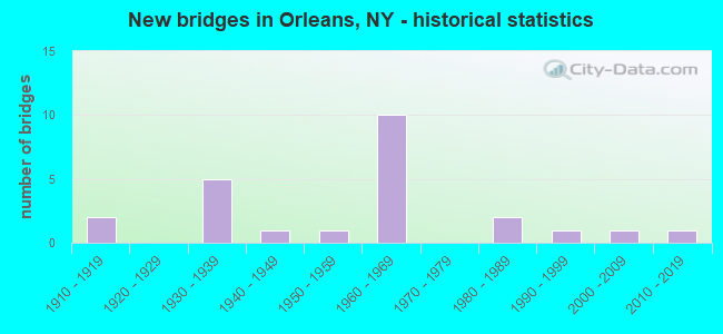
- New bridges - historical statistics
- 21910-1919
- 51930-1939
- 11940-1949
- 11950-1959
- 101960-1969
- 21980-1989
- 11990-1999
- 12000-2009
- 12010-2019

- Reconstructed bridges - Historical Statistics
- 21980-1989
- 01990-1999
- 12000-2009


- Bridge Condition - Deck
- 5.6%Excellent
- 27.8%Very good
- 16.7%Good
- 27.8%Satisfactory
- 16.7%Fair
- 5.6%Serious

- Bridge Condition - Superstructure
- 5.6%Excellent
- 22.2%Very good
- 16.7%Good
- 33.3%Satisfactory
- 16.7%Fair
- 5.6%Poor

- Bridge Condition - Substructure
- 5.6%Excellent
- 22.2%Very good
- 33.3%Good
- 16.7%Satisfactory
- 22.2%Fair

- Bridge Condition - Channel
- 57.1%Very good
- 14.3%Good
- 14.3%Satisfactory
- 14.3%Fair
Find on map >> Show street view
Structure Number: 100976, Location: 5.0 MI NE JCT 12 + 12E (Lat: 44.270950, Lng: -76.001728), Route carried "on" structure: State highway 12, Year Built: 1930, Status: Open, Structure Length: 1.49m (4.89ft), Average Daily Traffic: 4,675 (year 2020), Truck Traffic: 7%, Average Future Daily Traffic: 4,703 (year 2040), Design Load: H 20, Features Intersected: MULLET CREEK
Minimum Vertical Clearance: 30+ m (98+ ft), Kilometerpoint: 63.169, Lanes on structure: 2, Base Highway Network: Yes, Owner: State Highway Agency, Approaching Roadway Width: 12.2m (40.0ft), Material/Design: Steel, Design/Construction: Stringer/Multi-beam, Number Of Spans In Main Unit: 1, Length of Maximum Span: 13.7m (44.9ft), Curb-To-Curb Width: 9.8m (32.2ft), Out-to-Out Width: 10.4m (34.1ft)
Condition: Deck: Fair, Superstructure: Fair, Substructure: Fair, Channel: Satisfactory, Operating Rating: 51.7 metric tons, Method Used To Determine Operating Rating: Load Factor (LF), Inventory Rating: 30.8 metric tons, Method Used To Determine Inventory Rating: Load Factor (LF), Structural Evaluation: Somewhat better than minimum adequacy, Deck Geometry: Meets minimum limits, Waterway Adequacy: Meets minimum limits, Approach Roadway Alignment: Meets minimum limits, Length Of Structure Improvement: 1.49m (4.89ft), Designated Inspection Frequency: Every 24 months, Inspection Date: June 2020, Bridge Improvement Cost: $387,000, Roadway Improvement Cost: $227,000, Total Project Cost: $613,000 ( Estimate for 2021), Deck Structure Type: Concrete Cast-file-Place, Wearing Surface/Protective System: Wearing Surface: Bituminous, Membrane: Preformed Fabric
Find on map >> Show street view
Structure Number: 1032251, Location: JCT I81 SB & SH 411 (Lat: 44.191892, Lng: -75.879833), Route carried "on" structure: Interstate 81, Year Built: 1965, Status: Open, Structure Length: 3.96m (12.99ft), Average Daily Traffic: 4,824 (year 2015), Truck Traffic: 27%, Design Load: HS 20, Features Intersected: RTE 411
Minimum Vertical Clearance: 30+ m (98+ ft), Kilometerpoint: 62.896, Lanes on structure: 2, Lanes under structure: 2, Base Highway Network: Yes, Owner: State Highway Agency, Approaching Roadway Width: 11.0m (36.1ft), Material/Design: Steel, Design/Construction: Stringer/Multi-beam, Number Of Spans In Main Unit: 3, Length of Maximum Span: 14.0m (45.9ft), Curb or Sidewalk Widths: Left: 0.4m (1.3ft), Right: 0.4m (1.3ft), Curb-To-Curb Width: 9.1m (29.9ft), Out-to-Out Width: 10.7m (35.1ft)
Condition: Deck: Satisfactory, Superstructure: Satisfactory, Substructure: Fair, Operating Rating: 63.5 metric tons, Method Used To Determine Operating Rating: Load and Resistance Factor Rating (LRFR) rating reported by rating factor(RF) method using HL-93 loadings, Inventory Rating: 48.9 metric tons, Method Used To Determine Inventory Rating: Load and Resistance Factor Rating (LRFR) rating reported by rating factor(RF) method using HL-93 loadings, Structural Evaluation: Somewhat better than minimum adequacy, Deck Geometry: High priority of replacement, Underclear: Meets minimum limits, Approach Roadway Alignment: Equal to present desirable criteria, Length Of Structure Improvement: 3.96m (12.99ft), Designated Inspection Frequency: Every 24 months, Inspection Date: July 2020, Bridge Improvement Cost: $823,000, Roadway Improvement Cost: $482,000, Total Project Cost: $1,305,000 ( Estimate for 2021), Deck Structure Type: Concrete Cast-file-Place, Wearing Surface/Protective System: Wearing Surface: Bituminous
Find on map >> Show street view
Structure Number: 103227, Location: 1.6 MI N JCT I-81 + 411 (Lat: 44.211272, Lng: -75.893144), Route carried "on" structure: County highway , Year Built: 1965, Status: Open, Structure Length: 8.96m (29.40ft), Average Daily Traffic: 158 (year 2017), Truck Traffic: 7%, Average Future Daily Traffic: 221 (year 2037), Design Load: HS 20, Features Intersected: RTE I81, RTE I81, Facility Carried by Structure: COUNTY ROAD 15
Minimum Vertical Clearance: 30+ m (98+ ft), Kilometerpoint: 7.868, Lanes on structure: 2, Lanes under structure: 4, Owner: State Highway Agency, Approaching Roadway Width: 6.4m (21.0ft), Skew: 2 degrees, Material/Design: Steel, Design/Construction: Stringer/Multi-beam, Number Of Spans In Main Unit: 5, Length of Maximum Span: 19.5m (64.0ft), Curb or Sidewalk Widths: Left: 0.5m (1.6ft), Right: 0.5m (1.6ft), Curb-To-Curb Width: 9.1m (29.9ft), Out-to-Out Width: 10.7m (35.1ft)
Condition: Deck: Satisfactory, Superstructure: Satisfactory, Substructure: Satisfactory, Operating Rating: 57.2 metric tons, Method Used To Determine Operating Rating: Load Factor (LF), Inventory Rating: 33.6 metric tons, Method Used To Determine Inventory Rating: Load Factor (LF), Structural Evaluation: Equal to present minimum criteria, Deck Geometry: Equal to present minimum criteria, Underclear: High priority of corrective action, Approach Roadway Alignment: Equal to present desirable criteria, Length Of Structure Improvement: 8.96m (29.40ft), Designated Inspection Frequency: Every 24 months, Inspection Date: July 2020, Bridge Improvement Cost: $1,737,000, Roadway Improvement Cost: $1,017,000, Total Project Cost: $2,755,000 ( Estimate for 2021), Deck Structure Type: Concrete Cast-file-Place, Wearing Surface/Protective System: Wearing Surface: Bituminous, Membrane: Other
Find on map >> Show street view
Structure Number: 10395, Location: IN LAFARGEVILLE (Lat: 44.193386, Lng: -75.966706), Route carried "on" structure: State highway 180, Year Built: 1916, Status: Posted for load-capacity, Structure Length: 0.70m (2.30ft), Average Daily Traffic: 1,150 (year 2018), Truck Traffic: 9%, Average Future Daily Traffic: 1,199 (year 2040), Features Intersected: CHAUMONT RIVER
Minimum Vertical Clearance: 30+ m (98+ ft), Kilometerpoint: 28.978, Lanes on structure: 2, Base Highway Network: Yes, Owner: State Highway Agency, Approaching Roadway Width: 16.2m (53.1ft), Material/Design: Concrete, Design/Construction: Slab, Number Of Spans In Main Unit: 1, Length of Maximum Span: 6.7m (22.0ft), Curb or Sidewalk Widths: Left: 2.4m (7.9ft), Right: 1.5m (4.9ft), Curb-To-Curb Width: 16.2m (53.1ft), Out-to-Out Width: 24.3m (79.7ft)
Condition: Deck: Serious, Superstructure: Poor, Substructure: Fair, Channel: Very good, Operating Rating: 50.3 metric tons, Method Used To Determine Operating Rating: Field evaluation and documented engineering judgment, Inventory Rating: 14.7 metric tons, Method Used To Determine Inventory Rating: Field evaluation and documented engineering judgment, Structural Evaluation: Meets minimum limits, Deck Geometry: Superior to present desirable criteria, Waterway Adequacy: Somewhat better than minimum adequacy, Approach Roadway Alignment: Meets minimum limits, Length Of Structure Improvement: 0.70m (2.30ft), Designated Inspection Frequency: Every 12 months, Inspection Date: August 2021, Bridge Improvement Cost: $512,000, Roadway Improvement Cost: $300,000, Total Project Cost: $812,000 ( Estimate for 2021), Wearing Surface/Protective System: Wearing Surface: Bituminous
Find on map >> Show street view
Structure Number: 103951, Location: 1 MI NW OF OMAR (Lat: 44.270228, Lng: -75.993767), Route carried "on" structure: State highway 180, Year Built: 1980, Status: Open, Structure Length: 2.38m (7.81ft), Average Daily Traffic: 975 (year 2020), Truck Traffic: 7%, Average Future Daily Traffic: 1,017 (year 2040), Design Load: HS 20, Features Intersected: MULLET CREEK
Minimum Vertical Clearance: 30+ m (98+ ft), Kilometerpoint: 38.841, Lanes on structure: 2, Base Highway Network: Yes, Owner: State Highway Agency, Approaching Roadway Width: 10.4m (34.1ft), Material/Design: Prestressed concrete, Design/Construction: Box Beam or Girders - Multiple, Number Of Spans In Main Unit: 1, Length of Maximum Span: 22.2m (72.8ft), Curb-To-Curb Width: 10.4m (34.1ft), Out-to-Out Width: 11.3m (37.1ft)
Condition: Deck: Very good, Superstructure: Good, Substructure: Very good, Channel: Very good, Operating Rating: 76.2 metric tons, Method Used To Determine Operating Rating: Load Factor (LF), Inventory Rating: 38.1 metric tons, Method Used To Determine Inventory Rating: Load Factor (LF), Structural Evaluation: Better than present minimum criteria, Deck Geometry: Equal to present minimum criteria, Waterway Adequacy: Superior to present desirable criteria, Approach Roadway Alignment: Equal to present desirable criteria, Length Of Structure Improvement: 2.37m (7.78ft), Designated Inspection Frequency: Every 24 months, Inspection Date: June 2020, Bridge Improvement Cost: $494,000, Roadway Improvement Cost: $289,000, Total Project Cost: $783,000 ( Estimate for 2021), Wearing Surface/Protective System: Wearing Surface: Bituminous, Membrane: Other
Find on map >> Show street view
Structure Number: 103952, Location: IN FISHERS LANDING (Lat: 44.276231, Lng: -76.004817), Route carried "on" structure: County highway , Year Built: 2015, Status: Open, Structure Length: 2.04m (6.69ft), Average Daily Traffic: 536 (year 2015), Truck Traffic: 8%, Average Future Daily Traffic: 750 (year 2035), Design Load: HL 93, Features Intersected: MULLET CREEK, Facility Carried by Structure: COUNTY ROAD 195
Minimum Vertical Clearance: 30+ m (98+ ft), Kilometerpoint: 0.515, Lanes on structure: 2, Owner: County Highway Agency, Approaching Roadway Width: 7.6m (24.9ft), Material/Design: Prestressed concrete, Design/Construction: Tee Beam, Number Of Spans In Main Unit: 1, Length of Maximum Span: 20.1m (65.9ft), Curb-To-Curb Width: 9.3m (30.5ft), Out-to-Out Width: 10.4m (34.1ft)
Condition: Deck: Excellent, Superstructure: Excellent, Substructure: Excellent, Channel: Very good, Operating Rating: 63.8 metric tons, Method Used To Determine Operating Rating: Load and Resistance Factor Rating (LRFR) rating reported by rating factor(RF) method using HL-93 loadings, Inventory Rating: 49.2 metric tons, Method Used To Determine Inventory Rating: Load and Resistance Factor Rating (LRFR) rating reported by rating factor(RF) method using HL-93 loadings, Structural Evaluation: Superior to present desirable criteria, Deck Geometry: Equal to present minimum criteria, Waterway Adequacy: Somewhat better than minimum adequacy, Approach Roadway Alignment: Meets minimum limits, Length Of Structure Improvement: 2.04m (6.69ft), Designated Inspection Frequency: Every 24 months, Inspection Date: September 2021, Bridge Improvement Cost: $355,000, Roadway Improvement Cost: $208,000, Total Project Cost: $563,000 ( Estimate for 2021), Deck Structure Type: Concrete Cast-file-Place, Wearing Surface/Protective System: Wearing Surface: Bituminous
Find on map >> Show street view
Structure Number: 1060601, Location: 3.8 MI N JCT I-81+ST.LAWR (Lat: 44.340975, Lng: -75.980578), Route carried "on" structure: Interstate 81, Year Built: 1969, Status: Open, Structure Length: 3.69m (12.11ft), Average Daily Traffic: 2,850 (year 2014), Truck Traffic: 45%, Design Load: HS 20, Features Intersected: COUNTY ROAD 191, COUNTY
Minimum Vertical Clearance: 30+ m (98+ ft), Kilometerpoint: 85.229, Lanes on structure: 2, Lanes under structure: 8, Base Highway Network: Yes, Owner: State Highway Agency, Approaching Roadway Width: 12.2m (40.0ft), Material/Design: Steel, Design/Construction: Stringer/Multi-beam, Number Of Spans In Main Unit: 1, Length of Maximum Span: 36.5m (119.8ft), Curb or Sidewalk Widths: Left: 0.5m (1.6ft), Right: 0.5m (1.6ft), Curb-To-Curb Width: 12.5m (41.0ft), Out-to-Out Width: 13.4m (44.0ft)
Condition: Deck: Good, Superstructure: Very good, Substructure: Good, Operating Rating: 91.6 metric tons, Method Used To Determine Operating Rating: Load Factor (LF), Inventory Rating: 54.4 metric tons, Method Used To Determine Inventory Rating: Load Factor (LF), Structural Evaluation: Better than present minimum criteria, Deck Geometry: Better than present minimum criteria, Underclear: Somewhat better than minimum adequacy, Approach Roadway Alignment: Equal to present desirable criteria, Length Of Structure Improvement: 3.68m (12.07ft), Designated Inspection Frequency: Every 24 months, Inspection Date: October 2020, Bridge Improvement Cost: $1,242,000, Roadway Improvement Cost: $727,000, Total Project Cost: $1,969,000 ( Estimate for 2021), Deck Structure Type: Concrete Cast-file-Place, Wearing Surface/Protective System: Wearing Surface: Monolithic Concrete
Find on map >> Show street view
Structure Number: 1060602, Location: 3.8 MI N JCT I-81+ST.LAWR (Lat: 44.340869, Lng: -75.980225), Route carried "on" structure: Interstate 81, Year Built: 1969, Status: Open, Structure Length: 3.69m (12.11ft), Average Daily Traffic: 1,223 (year 2020), Truck Traffic: 54%, Average Future Daily Traffic: 1,456 (year 2040), Design Load: HS 20, Features Intersected: COUNTY ROAD 191, COUNTY
Minimum Vertical Clearance: 30+ m (98+ ft), Kilometerpoint: 85.229, Lanes on structure: 2, Lanes under structure: 4, Base Highway Network: Yes, Owner: State Highway Agency, Approaching Roadway Width: 11.9m (39.0ft), Material/Design: Steel, Design/Construction: Stringer/Multi-beam, Number Of Spans In Main Unit: 1, Length of Maximum Span: 36.5m (119.8ft), Curb or Sidewalk Widths: Left: 0.5m (1.6ft), Right: 0.5m (1.6ft), Curb-To-Curb Width: 12.5m (41.0ft), Out-to-Out Width: 13.4m (44.0ft)
Condition: Deck: Good, Superstructure: Very good, Substructure: Good, Operating Rating: 95.3 metric tons, Method Used To Determine Operating Rating: Load Factor (LF), Inventory Rating: 57.2 metric tons, Method Used To Determine Inventory Rating: Load Factor (LF), Structural Evaluation: Better than present minimum criteria, Deck Geometry: Better than present minimum criteria, Underclear: Somewhat better than minimum adequacy, Approach Roadway Alignment: Equal to present desirable criteria, Length Of Structure Improvement: 3.68m (12.07ft), Designated Inspection Frequency: Every 24 months, Inspection Date: October 2020, Bridge Improvement Cost: $1,310,000, Roadway Improvement Cost: $767,000, Total Project Cost: $2,077,000 ( Estimate for 2021), Deck Structure Type: Concrete Cast-file-Place, Wearing Surface/Protective System: Wearing Surface: Monolithic Concrete
Find on map >> Show street view
Structure Number: 107737, Location: 1.6 MI N JCT RTS 12 & 180 (Lat: 44.113667, Lng: -75.974483), Route carried "on" structure: State highway 180, Year Built: 1998, Status: Open, Structure Length: 1.01m (3.31ft), Average Daily Traffic: 1,150 (year 2018), Truck Traffic: 9%, Average Future Daily Traffic: 1,199 (year 2040), Design Load: HS 25 or greater, Features Intersected: STONE MILLS CREEK
Minimum Vertical Clearance: 30+ m (98+ ft), Kilometerpoint: 19.646, Lanes on structure: 2, Base Highway Network: Yes, Owner: State Highway Agency, Approaching Roadway Width: 10.4m (34.1ft), Skew: 3 degrees, Material/Design: Concrete, Design/Construction: Frame, Number Of Spans In Main Unit: 1, Length of Maximum Span: 9.1m (29.9ft), Curb or Sidewalk Widths: Left: 1.4m (4.6ft), Right: 0.0m, Curb-To-Curb Width: 10.4m (34.1ft), Out-to-Out Width: 12.8m (42.0ft)
Condition: Deck: Very good, Superstructure: Good, Substructure: Very good, Channel: Very good, Operating Rating: 79.1 metric tons, Method Used To Determine Operating Rating: Field evaluation and documented engineering judgment, Inventory Rating: 40.8 metric tons, Method Used To Determine Inventory Rating: Field evaluation and documented engineering judgment, Structural Evaluation: Better than present minimum criteria, Deck Geometry: Equal to present minimum criteria, Waterway Adequacy: Equal to present minimum criteria, Approach Roadway Alignment: Equal to present desirable criteria, Length Of Structure Improvement: 1.00m (3.28ft), Designated Inspection Frequency: Every 24 months, Inspection Date: August 2020, Bridge Improvement Cost: $438,000, Roadway Improvement Cost: $256,000, Total Project Cost: $694,000 ( Estimate for 2021), Wearing Surface/Protective System: Wearing Surface: Bituminous
Find on map >> Show street view
Structure Number: 109466, Location: 1.6 MI S JCT I81 & SH 411 (Lat: 44.167672, Lng: -75.878922), Route carried "on" structure: Interstate 81, Year Built: 1965, Status: Open, Structure Length: 0.91m (2.99ft), Average Daily Traffic: 6,632 (year 2020), Truck Traffic: 26%, Average Future Daily Traffic: 7,898 (year 2040), Design Load: HS 20, Features Intersected: HYDE CREEK
Minimum Vertical Clearance: 30+ m (98+ ft), Kilometerpoint: 61.271, Lanes on structure: 4, Base Highway Network: Yes, Owner: State Highway Agency, Approaching Roadway Width: 26.2m (86.0ft), Skew: 20 degrees, Material/Design: Steel, Design/Construction: Culvert, Number Of Spans In Main Unit: 2, Length of Maximum Span: 4.0m (13.1ft)
Condition: Channel: Fair, Culverts: Fair, Operating Rating: 74.2 metric tons, Method Used To Determine Operating Rating: Field evaluation and documented engineering judgment, Inventory Rating: 19.6 metric tons, Method Used To Determine Inventory Rating: Field evaluation and documented engineering judgment, Structural Evaluation: Meets minimum limits, Waterway Adequacy: Meets minimum limits, Approach Roadway Alignment: Equal to present desirable criteria, Length Of Structure Improvement: 0.91m (2.99ft), Designated Inspection Frequency: Every 24 months, Inspection Date: September 2020, Bridge Improvement Cost: $480,000, Roadway Improvement Cost: $281,000, Total Project Cost: $761,000 ( Estimate for 2021)
Find on map >> Show street view
Structure Number: 322012, Location: 5.0 MI E OF LA FARGEVILLE (Lat: 44.175897, Lng: -75.894464), Route carried "on" structure: Other road , Year Built: 1946, Status: Open, Structure Length: 0.79m (2.59ft), Average Daily Traffic: 14 (year 2019), Truck Traffic: 7%, Average Future Daily Traffic: 20 (year 2039), Features Intersected: HYDE CREEK, Facility Carried by Structure: SMITH ROAD
Minimum Vertical Clearance: 30+ m (98+ ft), Kilometerpoint: 1.255, Lanes on structure: 1, Owner: County Highway Agency, Approaching Roadway Width: 4.9m (16.1ft), Skew: 1 degrees, Material/Design: Steel, Design/Construction: Stringer/Multi-beam, Number Of Spans In Main Unit: 1, Length of Maximum Span: 7.3m (24.0ft), Curb-To-Curb Width: 4.8m (15.7ft), Out-to-Out Width: 5.9m (19.4ft)
Condition: Deck: Good, Superstructure: Good, Substructure: Good, Channel: Good, Operating Rating: 97.2 metric tons, Method Used To Determine Operating Rating: Load and Resistance Factor Rating (LRFR) rating reported by rating factor(RF) method using HL-93 loadings, Inventory Rating: 79.4 metric tons, Method Used To Determine Inventory Rating: Load and Resistance Factor Rating (LRFR) rating reported by rating factor(RF) method using HL-93 loadings, Structural Evaluation: Better than present minimum criteria, Deck Geometry: Equal to present desirable criteria, Waterway Adequacy: Better than present minimum criteria, Approach Roadway Alignment: Meets minimum limits, Length Of Structure Improvement: 0.79m (2.59ft), Designated Inspection Frequency: Every 24 months, Inspection Date: May 2020, Bridge Improvement Cost: $115,000, Roadway Improvement Cost: $67,000, Total Project Cost: $182,000 ( Estimate for 2021), Deck Structure Type: Concrete Cast-file-Place, Wearing Surface/Protective System: Wearing Surface: Bituminous
Find on map >> Show street view
Structure Number: 333925, Location: 9.0 MI SE OF LAFARGEVILLE (Lat: 44.120753, Lng: -75.941942), Route carried "on" structure: Other road , Year Built: 1938, Status: Open, Structure Length: 1.01m (3.31ft), Average Daily Traffic: 142 (year 2019), Truck Traffic: 7%, Average Future Daily Traffic: 199 (year 2039), Features Intersected: CARTER CREEK, Facility Carried by Structure: DOG HILL ROAD
Minimum Vertical Clearance: 30+ m (98+ ft), Kilometerpoint: 1.175, Lanes on structure: 2, Owner: County Highway Agency, Approaching Roadway Width: 4.9m (16.1ft), Material/Design: Steel, Design/Construction: Stringer/Multi-beam, Number Of Spans In Main Unit: 1, Length of Maximum Span: 8.5m (27.9ft), Curb-To-Curb Width: 6.1m (20.0ft), Out-to-Out Width: 6.9m (22.6ft)
Condition: Deck: Fair, Superstructure: Satisfactory, Substructure: Satisfactory, Inventory Rating: 64.4 metric tons, Method Used To Determine Inventory Rating: Load Factor (LF), Structural Evaluation: Equal to present minimum criteria, Deck Geometry: Meets minimum limits, Waterway Adequacy: Meets minimum limits, Approach Roadway Alignment: Somewhat better than minimum adequacy, Length Of Structure Improvement: 1.00m (3.28ft), Designated Inspection Frequency: Every 24 months, Inspection Date: August 2020, Bridge Improvement Cost: $245,000, Roadway Improvement Cost: $144,000, Total Project Cost: $389,000 ( Estimate for 2021), Deck Structure Type: Concrete Cast-file-Place, Wearing Surface/Protective System: Wearing Surface: Bituminous
Find on map >> Show street view
Structure Number: 333927, Location: 5.0 MI.SW OF ALEXANDRIA B (Lat: 44.275353, Lng: -75.976639), Route carried "on" structure: Other road , Year Built: 2002, Status: Open, Structure Length: 2.13m (6.99ft), Average Daily Traffic: 40 (year 2019), Truck Traffic: 7%, Average Future Daily Traffic: 56 (year 2039), Design Load: HS 25 or greater, Features Intersected: MULLET CREEK, Facility Carried by Structure: LEDGES ROAD
Minimum Vertical Clearance: 30+ m (98+ ft), Kilometerpoint: 1.673, Lanes on structure: 2, Owner: County Highway Agency, Approaching Roadway Width: 7.9m (25.9ft), Material/Design: Steel, Design/Construction: Truss - Thru, Number Of Spans In Main Unit: 1, Length of Maximum Span: 18.8m (61.7ft), Curb-To-Curb Width: 6.6m (21.7ft), Out-to-Out Width: 6.9m (22.6ft)
Condition: Deck: Very good, Superstructure: Very good, Substructure: Very good, Channel: Very good, Operating Rating: 49.0 metric tons, Method Used To Determine Operating Rating: Load Factor (LF), Inventory Rating: 29.0 metric tons, Method Used To Determine Inventory Rating: Load Factor (LF), Structural Evaluation: Better than present minimum criteria, Deck Geometry: Somewhat better than minimum adequacy, Waterway Adequacy: Equal to present minimum criteria, Approach Roadway Alignment: Meets minimum limits, Length Of Structure Improvement: 2.13m (6.99ft), Designated Inspection Frequency: Every 24 months, Critical Feature Inspection Frequency: Every 24 months, Inspection Date: September 2021, Critical Feature Inspection Date: September 2021, Bridge Improvement Cost: $911,000, Roadway Improvement Cost: $534,000, Total Project Cost: $1,445,000 ( Estimate for 2021), Deck Structure Type: Wood or Timber, Wearing Surface/Protective System: Wearing Surface: Bituminous, Membrane: Other
Find on map >> Show street view
Structure Number: 333928, Location: 6 MI SE OF LA FARGEVILLE (Lat: 44.154247, Lng: -75.899469), Route carried "on" structure: County highway , Year Built: 1961, Status: Open, Structure Length: 1.37m (4.49ft), Average Daily Traffic: 304 (year 2017), Truck Traffic: 8%, Average Future Daily Traffic: 426 (year 2037), Features Intersected: HYDE CREEK, Facility Carried by Structure: PERCH LAKE ROAD
Minimum Vertical Clearance: 30+ m (98+ ft), Kilometerpoint: 1.287, Lanes on structure: 2, Owner: County Highway Agency, Approaching Roadway Width: 5.5m (18.0ft), Material/Design: Steel, Design/Construction: Stringer/Multi-beam, Number Of Spans In Main Unit: 1, Length of Maximum Span: 12.1m (39.7ft), Curb or Sidewalk Widths: Left: 0.3m (1.0ft), Right: 0.3m (1.0ft), Curb-To-Curb Width: 7.3m (24.0ft), Out-to-Out Width: 8.0m (26.2ft)
Condition: Deck: Satisfactory, Superstructure: Satisfactory, Substructure: Good, Channel: Fair, Operating Rating: 36.3 metric tons, Method Used To Determine Operating Rating: Load Factor (LF), Inventory Rating: 21.8 metric tons, Method Used To Determine Inventory Rating: Load Factor (LF), Structural Evaluation: Equal to present minimum criteria, Deck Geometry: Somewhat better than minimum adequacy, Waterway Adequacy: Meets minimum limits, Approach Roadway Alignment: Equal to present desirable criteria, Length Of Structure Improvement: 1.37m (4.49ft), Designated Inspection Frequency: Every 24 months, Underwater Inspection Frequency: Every 60 months, Inspection Date: September 2020, Underwater Inspection Date: August 2018, Bridge Improvement Cost: $416,000, Roadway Improvement Cost: $243,000, Total Project Cost: $659,000 ( Estimate for 2021), Deck Structure Type: Open Grating, Wearing Surface/Protective System: Wearing Surface: Other
Find on map >> Show street view
Structure Number: 333951, Location: IN HAMLET OF LAFARGEVILLE (Lat: 44.192981, Lng: -75.970242), Route carried "on" structure: Other road , Year Built: 1981, Status: Open, Structure Length: 0.98m (3.22ft), Average Daily Traffic: 82 (year 2017), Truck Traffic: 7%, Average Future Daily Traffic: 115 (year 2037), Design Load: HS 20+Mod, Features Intersected: CHAUMONT RIVER, Facility Carried by Structure: FORD STREET
Minimum Vertical Clearance: 30+ m (98+ ft), Kilometerpoint: 0.241, Lanes on structure: 2, Owner: County Highway Agency, Approaching Roadway Width: 6.1m (20.0ft), Material/Design: Prestressed concrete, Design/Construction: Box Beam or Girders - Multiple, Number Of Spans In Main Unit: 1, Length of Maximum Span: 9.4m (30.8ft), Curb-To-Curb Width: 8.3m (27.2ft), Out-to-Out Width: 8.5m (27.9ft)
Condition: Deck: Satisfactory, Superstructure: Satisfactory, Substructure: Good, Channel: Satisfactory, Operating Rating: 59.9 metric tons, Method Used To Determine Operating Rating: Load Factor (LF), Inventory Rating: 35.4 metric tons, Method Used To Determine Inventory Rating: Load Factor (LF), Structural Evaluation: Equal to present minimum criteria, Deck Geometry: Equal to present minimum criteria, Waterway Adequacy: Superior to present desirable criteria, Approach Roadway Alignment: Meets minimum limits, Length Of Structure Improvement: 0.97m (3.18ft), Designated Inspection Frequency: Every 24 months, Inspection Date: June 2020, Bridge Improvement Cost: $154,000, Roadway Improvement Cost: $90,000, Total Project Cost: $245,000 ( Estimate for 2021), Wearing Surface/Protective System: Wearing Surface: Bituminous
Find on map >> Show street view
Structure Number: 333959, Location: 5 MI N OF LAFARGEVILLE (Lat: 44.260789, Lng: -75.972794), Route carried "on" structure: Business County highway , Year Built: 1911, Year Reconstructed: 1992, Status: Open, Structure Length: 0.94m (3.08ft), Average Daily Traffic: 332 (year 2018), Truck Traffic: 3%, Average Future Daily Traffic: 465 (year 2038), Design Load: HS 20, Features Intersected: MULLET CREEK, Facility Carried by Structure: CTY RD 13
Minimum Vertical Clearance: 30+ m (98+ ft), Kilometerpoint: 2.574, Lanes on structure: 2, Owner: County Highway Agency, Approaching Roadway Width: 9.1m (29.9ft), Skew: 4 degrees, Material/Design: Concrete, Design/Construction: Slab, Number Of Spans In Main Unit: 1, Length of Maximum Span: 8.8m (28.9ft), Curb-To-Curb Width: 9.1m (29.9ft), Out-to-Out Width: 9.8m (32.2ft)
Condition: Deck: Very good, Superstructure: Very good, Substructure: Good, Channel: Good, Operating Rating: 88.9 metric tons, Method Used To Determine Operating Rating: Load Factor (LF), Inventory Rating: 42.6 metric tons, Method Used To Determine Inventory Rating: Load Factor (LF), Structural Evaluation: Better than present minimum criteria, Deck Geometry: Equal to present minimum criteria, Waterway Adequacy: Somewhat better than minimum adequacy, Approach Roadway Alignment: Equal to present desirable criteria, Length Of Structure Improvement: 0.94m (3.08ft), Designated Inspection Frequency: Every 24 months, Inspection Date: August 2020, Bridge Improvement Cost: $335,000, Roadway Improvement Cost: $196,000, Total Project Cost: $532,000 ( Estimate for 2021), Wearing Surface/Protective System: Wearing Surface: Bituminous, Membrane: Other
Find on map >> Show street view
Structure Number: 552324, Location: 2.5 MI.SW OF ALEX. BAY (Lat: 44.301486, Lng: -75.981819), Route carried "on" structure: Interstate 81, Year Built: 1938, Year Reconstructed: 2000, Status: Open, Structure Length: 137.16m (450.00ft), Average Daily Traffic: 2,310 (year 2019), Truck Traffic: 31%, Average Future Daily Traffic: 2,751 (year 2040), Design Load: H 20, Features Intersected: COUNTY ROAD # 100, ST.LA
Minimum Vertical Clearance: 4.87m (15.98ft), Kilometerpoint: 77.940, Lanes on structure: 2, Lanes under structure: 7, Base Highway Network: Yes, Toll: Toll bridge, Owner: Local Toll Authority, Approaching Roadway Width: 7.3m (24.0ft), Navigation Control: Yes ( Vertical Clearance: 45.7m (149.9ft), Horizontal Clearance: 60.9m (199.8ft)), Material/Design: Steel, Design/Construction: Suspension, Number Of Spans In Main Unit: 3, Number Of Approach Spans: 42, Length of Maximum Span: 243.8m (799.9ft), Curb or Sidewalk Widths: Left: 0.9m (3.0ft), Right: 0.9m (3.0ft), Curb-To-Curb Width: 7.3m (24.0ft), Out-to-Out Width: 9.3m (30.5ft)
Condition: Deck: Satisfactory, Superstructure: Fair, Substructure: Very good, Channel: Very good, Operating Rating: 81.9 metric tons, Method Used To Determine Operating Rating: Field evaluation and documented engineering judgment, Inventory Rating: 32.7 metric tons, Method Used To Determine Inventory Rating: Field evaluation and documented engineering judgment, Structural Evaluation: Somewhat better than minimum adequacy, Deck Geometry: High priority of replacement, Underclear: Somewhat better than minimum adequacy, Waterway Adequacy: Equal to present desirable criteria, Approach Roadway Alignment: Equal to present desirable criteria, Length Of Structure Improvement: 137.16m (450.00ft), Designated Inspection Frequency: Every 24 months, Critical Feature Inspection Frequency: Every 24 months, Inspection Date: July 2021, Critical Feature Inspection Date: July 2021, Bridge Improvement Cost: $103,335,000, Roadway Improvement Cost: $60,513,000, Total Project Cost: $163,848,000 ( Estimate for 2021), Deck Structure Type: Closed Grating, Wearing Surface/Protective System: Wearing Surface: Other
Find on map >> Show street view
Structure Number: 5523251, Location: 5.0 MI.NW ALEXANDRIA BAY (Lat: 44.347147, Lng: -75.983542), Route carried "on" structure: Other road 81, Year Built: 1938, Year Reconstructed: 1987, Status: Open, Structure Length: 3.11m (10.20ft), Average Daily Traffic: 2,850 (year 2014), Truck Traffic: 45%, Features Intersected: ST.LAWRENCE RV.CH
Minimum Vertical Clearance: 30+ m (98+ ft), Kilometerpoint: 86.017, Lanes on structure: 2, Base Highway Network: Yes, Toll: On toll road, Owner: Local Toll Authority, Approaching Roadway Width: 9.1m (29.9ft), Material/Design: Concrete, Design/Construction: Frame, Number Of Spans In Main Unit: 1, Length of Maximum Span: 29.2m (95.8ft), Curb or Sidewalk Widths: Left: 1.2m (3.9ft), Right: 1.2m (3.9ft), Curb-To-Curb Width: 9.1m (29.9ft), Out-to-Out Width: 12.5m (41.0ft)
Condition: Deck: Fair, Superstructure: Fair, Substructure: Fair, Channel: Very good, Operating Rating: 71.7 metric tons, Method Used To Determine Operating Rating: Field evaluation and documented engineering judgment, Inventory Rating: 26.2 metric tons, Method Used To Determine Inventory Rating: Field evaluation and documented engineering judgment, Structural Evaluation: Somewhat better than minimum adequacy, Deck Geometry: High priority of replacement, Waterway Adequacy: Equal to present minimum criteria, Approach Roadway Alignment: Equal to present desirable criteria, Length Of Structure Improvement: 3.10m (10.17ft), Designated Inspection Frequency: Every 24 months, Inspection Date: July 2021, Bridge Improvement Cost: $652,000, Roadway Improvement Cost: $382,000, Total Project Cost: $1,034,000 ( Estimate for 2021), Wearing Surface/Protective System: Wearing Surface: Bituminous
Find on map >> Show street view
Structure Number: 5523252, Location: 5.0 MI.NW ALEXANDRIA BAY (Lat: 44.347253, Lng: -75.983225), Route carried "on" structure: Other road 81, Year Built: 1959, Status: Open, Structure Length: 3.11m (10.20ft), Average Daily Traffic: 1,223 (year 2011), Truck Traffic: 45%, Average Future Daily Traffic: 1,456 (year 2040), Features Intersected: ST.LAWRENCE RV.CH
Minimum Vertical Clearance: 30+ m (98+ ft), Kilometerpoint: 85.856, Lanes on structure: 3, Base Highway Network: Yes, Toll: On toll road, Owner: Local Toll Authority, Approaching Roadway Width: 14.6m (47.9ft), Material/Design: Concrete, Design/Construction: Frame, Number Of Spans In Main Unit: 1, Length of Maximum Span: 29.2m (95.8ft), Curb or Sidewalk Widths: Left: 0.4m (1.3ft), Right: 0.4m (1.3ft), Curb-To-Curb Width: 14.6m (47.9ft), Out-to-Out Width: 16.6m (54.5ft)
Condition: Deck: Very good, Superstructure: Satisfactory, Substructure: Satisfactory, Channel: Very good, Operating Rating: 93.4 metric tons, Method Used To Determine Operating Rating: Field evaluation and documented engineering judgment, Inventory Rating: 32.7 metric tons, Method Used To Determine Inventory Rating: Field evaluation and documented engineering judgment, Structural Evaluation: Equal to present minimum criteria, Deck Geometry: Meets minimum limits, Waterway Adequacy: Equal to present minimum criteria, Approach Roadway Alignment: Equal to present desirable criteria, Length Of Structure Improvement: 3.10m (10.17ft), Designated Inspection Frequency: Every 24 months, Inspection Date: July 2021, Bridge Improvement Cost: $863,000, Roadway Improvement Cost: $506,000, Total Project Cost: $1,369,000 ( Estimate for 2021), Wearing Surface/Protective System: Wearing Surface: Bituminous
Find on map >> Show street view
Structure Number: 1032251, Location: JCT I81 SB & SH 411 (Lat: 44.191892, Lng: -75.879833), Route carried "under" structure: State highway 411, Year Built: 1965, Structure Length: 0. m, Average Daily Traffic: 900 (year 1972), Features Intersected: RTE 411, Facility Carried by Structure: RTE I81
Minimum Vertical Clearance: 4.31m (14.14ft), Kilometerpoint: 0.000, Lanes on structure: 2, Lanes under structure: 2, Material/Design: Steel, Design/Construction: Stringer/Multi-beam, Length of Maximum Span: 14.0m (45.9ft)
Find on map >> Show street view
Structure Number: 103227, Location: 1.6 MI N JCT I-81 + 411 (Lat: 44.211272, Lng: -75.893144), Route carried "under" structure: Interstate 81, Year Built: 1965, Structure Length: 0. m, Average Daily Traffic: 7,111 (year 2000), Features Intersected: RTE I81, RTE I81, Facility Carried by Structure: COUNTY ROAD 15
Minimum Vertical Clearance: 4.87m (15.98ft), Kilometerpoint: 65.132, Lanes on structure: 2, Lanes under structure: 2, Material/Design: Steel, Design/Construction: Stringer/Multi-beam, Length of Maximum Span: 19.5m (64.0ft)
Find on map >> Show street view
Structure Number: 1060601, Location: 3.8 MI N JCT I-81+ST.LAWR (Lat: 44.340975, Lng: -75.980578), Route carried "under" structure: County highway , Year Built: 1969, Structure Length: 0. m, Average Daily Traffic: 46 (year 2013), Truck Traffic: 7%, Features Intersected: COUNTY ROAD 191, COUNTY, Facility Carried by Structure: RTE I81
Minimum Vertical Clearance: 4.75m (15.58ft), Kilometerpoint: 5.873, Lanes on structure: 2, Lanes under structure: 4, Material/Design: Steel, Design/Construction: Stringer/Multi-beam, Length of Maximum Span: 36.5m (119.8ft)
Find on map >> Show street view
Structure Number: 1060602, Location: 3.8 MI N JCT I-81+ST.LAWR (Lat: 44.340869, Lng: -75.980225), Route carried "under" structure: County highway , Year Built: 1969, Structure Length: 0. m, Average Daily Traffic: 46 (year 2013), Truck Traffic: 7%, Features Intersected: COUNTY ROAD 191, COUNTY, Facility Carried by Structure: RTE I81
Minimum Vertical Clearance: 5.82m (19.09ft), Kilometerpoint: 5.776, Lanes on structure: 2, Lanes under structure: 2, Material/Design: Steel, Design/Construction: Stringer/Multi-beam, Length of Maximum Span: 36.5m (119.8ft)
Find on map >> Show street view
Structure Number: 552324, Location: 2.5 MI.SW OF ALEX. BAY (Lat: 44.301486, Lng: -75.981819), Route carried "under" structure: ServiceOther road , Year Built: 1938, Structure Length: 0. m, Average Daily Traffic: 150 (year 2021), Features Intersected: COUNTY ROAD # 100, ST.LA, Facility Carried by Structure: RTE I81
Minimum Vertical Clearance: 5.30m (17.39ft), Kilometerpoint: 0.000, Lanes on structure: 2, Lanes under structure: 7, Toll: Toll bridge, Material/Design: Steel, Design/Construction: Suspension, Length of Maximum Span: 243.8m (799.9ft)