Bridge Statistics for Old Westbury, New York (NY)
Condition, Traffic, Stress, Structural Evaluation, Project Costs
- National Bridge Inventory (NBI) Statistics
- 26Number of bridges
- 141ft / 42.9mTotal length
- $93,541,000Total costs
- 1,915,202Total average daily traffic
- 44,282Total average daily truck traffic
- National Bridge Inventory (NBI) Registered Bridges for Old Westbury
- No street view available for this location
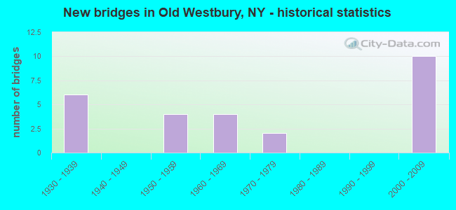
- New bridges - historical statistics
- 61930-1939
- 41950-1959
- 41960-1969
- 21970-1979
- 102000-2009

- Reconstructed bridges - Historical Statistics
- 11990-1999
- 12000-2009


- Bridge Condition - Deck
- 75.0%Good
- 25.0%Satisfactory

- Bridge Condition - Superstructure
- 25.0%Good
- 66.7%Satisfactory
- 8.3%Fair

- Bridge Condition - Substructure
- 66.7%Good
- 16.7%Satisfactory
- 16.7%Fair
Find on map >> Show street view
Structure Number: 1018399, Location: RTE 25B+NSP EB (Lat: 40.759992, Lng: -73.623778), Route carried "on" structure: Alternate State highway 25B, Year Built: 1934, Status: Open, Structure Length: 1.98m (6.50ft), Average Daily Traffic: 11,438 (year 2020), Truck Traffic: 3%, Average Future Daily Traffic: 13,197 (year 2040), Design Load: H 20, Features Intersected: RTE 908G
Minimum Vertical Clearance: 30+ m (98+ ft), Kilometerpoint: 7.047, Lanes on structure: 4, Lanes under structure: 4, Base Highway Network: Yes, Owner: State Highway Agency, Approaching Roadway Width: 17.1m (56.1ft), Skew: 21 degrees, Material/Design: Concrete, Design/Construction: Arch - Deck, Number Of Spans In Main Unit: 1, Length of Maximum Span: 18.2m (59.7ft), Curb or Sidewalk Widths: Left: 2.1m (6.9ft), Right: 2.0m (6.6ft), Curb-To-Curb Width: 17.1m (56.1ft), Out-to-Out Width: 23.7m (77.8ft)
Condition: Superstructure: Satisfactory, Substructure: Good, Operating Rating: 89.8 metric tons, Method Used To Determine Operating Rating: Load Factor (LF), Inventory Rating: 78.0 metric tons, Method Used To Determine Inventory Rating: Load Factor (LF), Structural Evaluation: Equal to present minimum criteria, Deck Geometry: Somewhat better than minimum adequacy, Underclear: High priority of corrective action, Approach Roadway Alignment: Equal to present desirable criteria, Length Of Structure Improvement: 1.98m (6.50ft), Designated Inspection Frequency: Every 24 months, Inspection Date: March 2021, Bridge Improvement Cost: $3,550,000, Roadway Improvement Cost: $2,079,000, Total Project Cost: $5,629,000 ( Estimate for 2021), Wearing Surface/Protective System: Wearing Surface: Bituminous, Membrane: Preformed Fabric
Find on map >> Show street view
Structure Number: 104909, Location: 3.9 MI W JCT I495 & SH 25 (Lat: 40.783217, Lng: -73.623003), Route carried "on" structure: Other road , Year Built: 2000, Status: Open, Structure Length: 5.15m (16.90ft), Average Daily Traffic: 31,379 (year 2020), Truck Traffic: 7%, Average Future Daily Traffic: 36,205 (year 2040), Design Load: HS 25 or greater, Features Intersected: 495I495I03021057, RTE I4, Facility Carried by Structure: GLEN COVE ROAD
Minimum Vertical Clearance: 30+ m (98+ ft), Kilometerpoint: 8.705, Lanes on structure: 6, Lanes under structure: 10, Owner: State Highway Agency, Approaching Roadway Width: 27.1m (88.9ft), Skew: 20 degrees, Material/Design: Steel continuous, Design/Construction: Stringer/Multi-beam, Number Of Spans In Main Unit: 2, Length of Maximum Span: 25.4m (83.3ft), Curb or Sidewalk Widths: Left: 1.5m (4.9ft), Right: 1.5m (4.9ft), Curb-To-Curb Width: 27.2m (89.2ft), Out-to-Out Width: 31.4m (103.0ft)
Condition: Deck: Good, Superstructure: Good, Substructure: Good, Inventory Rating: 80.7 metric tons, Method Used To Determine Inventory Rating: Load Factor (LF), Structural Evaluation: Better than present minimum criteria, Deck Geometry: Better than present minimum criteria, Underclear: High priority of corrective action, Approach Roadway Alignment: Equal to present desirable criteria, Length Of Structure Improvement: 5.15m (16.90ft), Designated Inspection Frequency: Every 24 months, Inspection Date: Febuary 2020, Bridge Improvement Cost: $8,306,000, Roadway Improvement Cost: $4,864,000, Total Project Cost: $13,170,000 ( Estimate for 2021), Deck Structure Type: Concrete Cast-file-Place, Wearing Surface/Protective System: Wearing Surface: Integral Concrete, Deck Protection: Epoxy Coated Reinforcing
Find on map >> Show street view
Structure Number: 10491, Location: 3.5 MI W I495 & SH 25 (Lat: 40.783144, Lng: -73.614956), Route carried "on" structure: County highway , Year Built: 2004, Status: Open, Structure Length: 4.54m (14.90ft), Average Daily Traffic: 1,296 (year 2018), Truck Traffic: 4%, Average Future Daily Traffic: 1,603 (year 2040), Design Load: HS 25 or greater, Features Intersected: 495I495I03021061, RTE I4, Facility Carried by Structure: RED GROUND ROAD
Minimum Vertical Clearance: 30+ m (98+ ft), Kilometerpoint: 0.016, Lanes on structure: 2, Lanes under structure: 8, Owner: State Highway Agency, Approaching Roadway Width: 13.7m (44.9ft), Skew: 1 degrees, Material/Design: Prestressed concrete continuous, Design/Construction: Box Beam or Girders - Multiple, Number Of Spans In Main Unit: 2, Length of Maximum Span: 23.5m (77.1ft), Curb or Sidewalk Widths: Left: 1.6m (5.2ft), Right: 1.6m (5.2ft), Curb-To-Curb Width: 13.8m (45.3ft), Out-to-Out Width: 18.1m (59.4ft)
Condition: Deck: Good, Superstructure: Satisfactory, Substructure: Good, Operating Rating: 85.3 metric tons, Method Used To Determine Operating Rating: Load Factor (LF), Inventory Rating: 41.7 metric tons, Method Used To Determine Inventory Rating: Load Factor (LF), Structural Evaluation: Equal to present minimum criteria, Deck Geometry: Superior to present desirable criteria, Underclear: High priority of corrective action, Approach Roadway Alignment: Equal to present minimum criteria, Length Of Structure Improvement: 4.54m (14.90ft), Designated Inspection Frequency: Every 24 months, Inspection Date: Febuary 2020, Bridge Improvement Cost: $3,343,000, Roadway Improvement Cost: $1,958,000, Total Project Cost: $5,301,000 ( Estimate for 2021), Wearing Surface/Protective System: Wearing Surface: Monolithic Concrete
Find on map >> Show street view
Structure Number: 104911, Location: 3.1 MI W JCT I495 & SH 25 (Lat: 40.780189, Lng: -73.608450), Route carried "on" structure: Other road , Year Built: 2000, Status: Open, Structure Length: 4.39m (14.40ft), Average Daily Traffic: 2,035 (year 2020), Truck Traffic: 4%, Average Future Daily Traffic: 2,517 (year 2040), Design Load: HS 25 or greater, Features Intersected: 495I495I03021065, RTE I4, Facility Carried by Structure: WHEATLY RD
Minimum Vertical Clearance: 30+ m (98+ ft), Kilometerpoint: 0.016, Lanes on structure: 2, Lanes under structure: 8, Owner: State Highway Agency, Approaching Roadway Width: 13.7m (44.9ft), Material/Design: Prestressed concrete continuous, Design/Construction: Box Beam or Girders - Multiple, Number Of Spans In Main Unit: 2, Length of Maximum Span: 22.2m (72.8ft), Curb or Sidewalk Widths: Left: 1.6m (5.2ft), Right: 1.6m (5.2ft), Curb-To-Curb Width: 13.7m (44.9ft), Out-to-Out Width: 18.0m (59.1ft)
Condition: Deck: Good, Superstructure: Satisfactory, Substructure: Good, Operating Rating: 71.7 metric tons, Method Used To Determine Operating Rating: Load Factor (LF), Inventory Rating: 32.7 metric tons, Method Used To Determine Inventory Rating: Load Factor (LF), Structural Evaluation: Equal to present minimum criteria, Deck Geometry: Superior to present desirable criteria, Underclear: High priority of corrective action, Approach Roadway Alignment: Equal to present desirable criteria, Length Of Structure Improvement: 4.38m (14.37ft), Designated Inspection Frequency: Every 24 months, Inspection Date: Febuary 2020, Bridge Improvement Cost: $3,128,000, Roadway Improvement Cost: $1,832,000, Total Project Cost: $4,959,000 ( Estimate for 2021), Deck Structure Type: Concrete Cast-file-Place, Wearing Surface/Protective System: Wearing Surface: Integral Concrete, Deck Protection: Epoxy Coated Reinforcing
Find on map >> Show street view
Structure Number: 104912, Location: 4.7 KM W JCT I495 & SH 25 (Lat: 40.779764, Lng: -73.605397), Route carried "on" structure: City street , Year Built: 2004, Status: Open, Structure Length: 4.36m (14.30ft), Average Daily Traffic: 1,368 (year 2020), Truck Traffic: 6%, Average Future Daily Traffic: 1,692 (year 2040), Design Load: HS 25 or greater, Features Intersected: 495I 495I03021067, RTE, Facility Carried by Structure: OLD WESTBURY ROAD
Minimum Vertical Clearance: 30+ m (98+ ft), Kilometerpoint: 1.915, Lanes on structure: 4, Lanes under structure: 8, Owner: State Highway Agency, Approaching Roadway Width: 13.7m (44.9ft), Material/Design: Prestressed concrete continuous, Design/Construction: Box Beam or Girders - Multiple, Number Of Spans In Main Unit: 2, Length of Maximum Span: 22.3m (73.2ft), Curb or Sidewalk Widths: Left: 1.7m (5.6ft), Right: 1.7m (5.6ft), Curb-To-Curb Width: 13.8m (45.3ft), Out-to-Out Width: 18.3m (60.0ft)
Condition: Deck: Good, Superstructure: Satisfactory, Substructure: Good, Operating Rating: 88.0 metric tons, Method Used To Determine Operating Rating: Load Factor (LF), Inventory Rating: 49.9 metric tons, Method Used To Determine Inventory Rating: Load Factor (LF), Structural Evaluation: Equal to present minimum criteria, Deck Geometry: High priority of replacement, Underclear: High priority of corrective action, Approach Roadway Alignment: Equal to present desirable criteria, Length Of Structure Improvement: 4.35m (14.27ft), Designated Inspection Frequency: Every 24 months, Inspection Date: Febuary 2020, Bridge Improvement Cost: $3,223,000, Roadway Improvement Cost: $1,888,000, Total Project Cost: $5,111,000 ( Estimate for 2021), Deck Structure Type: Concrete Cast-file-Place, Wearing Surface/Protective System: Wearing Surface: Monolithic Concrete, Deck Protection: Epoxy Coated Reinforcing
Find on map >> Show street view
Structure Number: 1049139, Location: 2 MI W JCT I495 & SH 25 (Lat: 40.783486, Lng: -73.589458), Route carried "on" structure: Interstate 495, Year Built: 1962, Year Reconstructed: 2006, Status: Open, Structure Length: 2.53m (8.30ft), Average Daily Traffic: 145,449 (year 2018), Truck Traffic: 12%, Average Future Daily Traffic: 152,721 (year 2040), Design Load: HS 20+Mod, Features Intersected: POST ROAD
Minimum Vertical Clearance: 30+ m (98+ ft), Kilometerpoint: 12.100, Lanes on structure: 8, Lanes under structure: 4, Base Highway Network: Yes, Owner: State Highway Agency, Approaching Roadway Width: 39.6m (129.9ft), Skew: 20 degrees, Material/Design: Concrete, Design/Construction: Frame, Number Of Spans In Main Unit: 1, Length of Maximum Span: 23.7m (77.8ft), Curb-To-Curb Width: 39.5m (129.6ft), Out-to-Out Width: 41.5m (136.2ft)
Condition: Deck: Satisfactory, Superstructure: Fair, Substructure: Fair, Operating Rating: 82.7 metric tons, Method Used To Determine Operating Rating: Field evaluation and documented engineering judgment, Inventory Rating: 19.6 metric tons, Method Used To Determine Inventory Rating: Field evaluation and documented engineering judgment, Structural Evaluation: Meets minimum limits, Deck Geometry: Superior to present desirable criteria, Underclear: Meets minimum limits, Approach Roadway Alignment: Better than present minimum criteria, Length Of Structure Improvement: 2.52m (8.27ft), Designated Inspection Frequency: Every 24 months, Inspection Date: July 2020, Bridge Improvement Cost: $6,028,000, Roadway Improvement Cost: $3,530,000, Total Project Cost: $9,558,000 ( Estimate for 2021), Deck Structure Type: Concrete Cast-file-Place, Wearing Surface/Protective System: Wearing Surface: Integral Concrete, Deck Protection: Epoxy Coated Reinforcing
Find on map >> Show street view
Structure Number: 104915, Location: 1.2 MI W JCT I495 & SH 25 (Lat: 40.778978, Lng: -73.577097), Route carried "on" structure: Other road , Year Built: 2000, Status: Open, Structure Length: 4.30m (14.11ft), Average Daily Traffic: 2,333 (year 2017), Truck Traffic: 3%, Average Future Daily Traffic: 3,266 (year 2037), Design Load: HS 25 or greater, Features Intersected: 495I 495I 03021083 WB, R, Facility Carried by Structure: POWELLS LANE
Minimum Vertical Clearance: 30+ m (98+ ft), Kilometerpoint: 0.805, Lanes on structure: 2, Lanes under structure: 8, Owner: State Highway Agency, Approaching Roadway Width: 13.7m (44.9ft), Material/Design: Prestressed concrete, Design/Construction: Box Beam or Girders - Multiple, Number Of Spans In Main Unit: 2, Length of Maximum Span: 22.5m (73.8ft), Curb or Sidewalk Widths: Left: 1.7m (5.6ft), Right: 1.7m (5.6ft), Curb-To-Curb Width: 13.8m (45.3ft), Out-to-Out Width: 18.1m (59.4ft)
Condition: Deck: Good, Superstructure: Satisfactory, Substructure: Satisfactory, Operating Rating: 67.1 metric tons, Method Used To Determine Operating Rating: Load Factor (LF), Inventory Rating: 29.0 metric tons, Method Used To Determine Inventory Rating: Load Factor (LF), Structural Evaluation: Equal to present minimum criteria, Deck Geometry: Superior to present desirable criteria, Underclear: High priority of corrective action, Approach Roadway Alignment: Equal to present desirable criteria, Length Of Structure Improvement: 4.29m (14.07ft), Designated Inspection Frequency: Every 24 months, Inspection Date: June 2020, Bridge Improvement Cost: $3,248,000, Roadway Improvement Cost: $1,902,000, Total Project Cost: $5,149,000 ( Estimate for 2021), Deck Structure Type: Concrete Cast-file-Place, Wearing Surface/Protective System: Wearing Surface: Integral Concrete, Deck Protection: Epoxy Coated Reinforcing
Find on map >> Show street view
Structure Number: 105708, Location: NSP - 5 MI EAST QNS CO LN (Lat: 40.772181, Lng: -73.625472), Route carried "on" structure: County highway , Year Built: 1959, Status: Open, Structure Length: 2.16m (7.09ft), Average Daily Traffic: 10,474 (year 2020), Truck Traffic: 3%, Average Future Daily Traffic: 14,664 (year 2040), Design Load: HS 20, Features Intersected: RTE 908G, Facility Carried by Structure: I.U. WILLETS ROAD
Minimum Vertical Clearance: 30+ m (98+ ft), Kilometerpoint: 3.894, Lanes on structure: 3, Lanes under structure: 4, Owner: State Highway Agency, Approaching Roadway Width: 11.5m (37.7ft), Material/Design: Concrete, Design/Construction: Arch - Deck, Number Of Spans In Main Unit: 1, Length of Maximum Span: 19.8m (65.0ft), Curb or Sidewalk Widths: Left: 1.8m (5.9ft), Right: 1.8m (5.9ft), Curb-To-Curb Width: 11.6m (38.1ft), Out-to-Out Width: 16.5m (54.1ft)
Condition: Superstructure: Satisfactory, Substructure: Good, Operating Rating: 85.3 metric tons, Method Used To Determine Operating Rating: Field evaluation and documented engineering judgment, Inventory Rating: 29.4 metric tons, Method Used To Determine Inventory Rating: Field evaluation and documented engineering judgment, Structural Evaluation: Equal to present minimum criteria, Deck Geometry: High priority of replacement, Underclear: High priority of corrective action, Approach Roadway Alignment: Equal to present desirable criteria, Length Of Structure Improvement: 2.16m (7.09ft), Designated Inspection Frequency: Every 24 months, Inspection Date: January 2020, Bridge Improvement Cost: $2,804,000, Roadway Improvement Cost: $1,642,000, Total Project Cost: $4,446,000 ( Estimate for 2021), Wearing Surface/Protective System: Wearing Surface: Bituminous, Membrane: Preformed Fabric
Find on map >> Show street view
Structure Number: 105808, Location: NSP-5 MI E QNS CL (Lat: 40.772183, Lng: -73.625775), Route carried "on" structure: County highway , Year Built: 1934, Status: Open, Structure Length: 1.95m (6.40ft), Average Daily Traffic: 10,474 (year 2020), Truck Traffic: 3%, Average Future Daily Traffic: 12,723 (year 2040), Features Intersected: RTE 908G, Facility Carried by Structure: I.U. WILLETS RD
Minimum Vertical Clearance: 30+ m (98+ ft), Kilometerpoint: 3.846, Lanes on structure: 3, Lanes under structure: 4, Owner: State Highway Agency, Approaching Roadway Width: 11.5m (37.7ft), Material/Design: Concrete, Design/Construction: Arch - Deck, Number Of Spans In Main Unit: 1, Length of Maximum Span: 17.6m (57.7ft), Curb or Sidewalk Widths: Left: 1.8m (5.9ft), Right: 1.8m (5.9ft), Curb-To-Curb Width: 11.6m (38.1ft), Out-to-Out Width: 16.5m (54.1ft)
Condition: Superstructure: Satisfactory, Substructure: Good, Operating Rating: 56.1 metric tons, Method Used To Determine Operating Rating: Field evaluation and documented engineering judgment, Inventory Rating: 22.4 metric tons, Method Used To Determine Inventory Rating: Field evaluation and documented engineering judgment, Structural Evaluation: Somewhat better than minimum adequacy, Deck Geometry: High priority of replacement, Underclear: High priority of corrective action, Approach Roadway Alignment: Equal to present desirable criteria, Length Of Structure Improvement: 1.95m (6.40ft), Designated Inspection Frequency: Every 24 months, Inspection Date: January 2020, Bridge Improvement Cost: $2,568,000, Roadway Improvement Cost: $1,504,000, Total Project Cost: $4,071,000 ( Estimate for 2021), Wearing Surface/Protective System: Wearing Surface: Bituminous, Membrane: Preformed Fabric
Find on map >> Show street view
Structure Number: 1058099, Location: RTE 25+NSP (Lat: 40.756594, Lng: -73.621172), Route carried "on" structure: State highway 908G, Year Built: 1936, Status: Open, Structure Length: 2.74m (8.99ft), Average Daily Traffic: 153,006 (year 2018), Average Future Daily Traffic: 182,000 (year 2040), Features Intersected: RTE 25
Minimum Vertical Clearance: 30+ m (98+ ft), Kilometerpoint: 10.748, Lanes on structure: 10, Lanes under structure: 5, Base Highway Network: Yes, Owner: State Highway Agency, Approaching Roadway Width: 54.2m (177.8ft), Skew: 21 degrees, Material/Design: Concrete, Design/Construction: Arch - Deck, Number Of Spans In Main Unit: 1, Length of Maximum Span: 26.2m (86.0ft), Curb-To-Curb Width: 54.3m (178.1ft), Out-to-Out Width: 67.7m (222.1ft)
Condition: Superstructure: Satisfactory, Substructure: Good, Operating Rating: 67.0 metric tons, Method Used To Determine Operating Rating: Field evaluation and documented engineering judgment, Inventory Rating: 25.0 metric tons, Method Used To Determine Inventory Rating: Field evaluation and documented engineering judgment, Structural Evaluation: Equal to present minimum criteria, Deck Geometry: Superior to present desirable criteria, Underclear: High priority of corrective action, Approach Roadway Alignment: Equal to present desirable criteria, Length Of Structure Improvement: 2.74m (8.99ft), Designated Inspection Frequency: Every 24 months, Inspection Date: January 2020, Bridge Improvement Cost: $16,574,000, Roadway Improvement Cost: $9,706,000, Total Project Cost: $26,280,000 ( Estimate for 2021)
Find on map >> Show street view
Structure Number: 106077, Location: NY25 & NY25B (Lat: 40.759967, Lng: -73.615942), Route carried "on" structure: State highway 25B, Year Built: 1968, Status: Open, Structure Length: 6.04m (19.82ft), Average Daily Traffic: 9,289 (year 2020), Truck Traffic: 8%, Average Future Daily Traffic: 10,717 (year 2040), Design Load: HS 20, Features Intersected: RTE 25
Minimum Vertical Clearance: 30+ m (98+ ft), Kilometerpoint: 7.659, Lanes on structure: 2, Lanes under structure: 2, Base Highway Network: Yes, Owner: State Highway Agency, Approaching Roadway Width: 11.6m (38.1ft), Skew: 5 degrees, Material/Design: Steel, Design/Construction: Stringer/Multi-beam, Number Of Spans In Main Unit: 3, Length of Maximum Span: 27.4m (89.9ft), Curb or Sidewalk Widths: Left: 0.0m, Right: 1.5m (4.9ft), Curb-To-Curb Width: 11.6m (38.1ft), Out-to-Out Width: 14.2m (46.6ft)
Condition: Deck: Satisfactory, Superstructure: Good, Substructure: Fair, Operating Rating: 51.5 metric tons, Method Used To Determine Operating Rating: Load and Resistance Factor Rating (LRFR) rating reported by rating factor(RF) method using HL-93 loadings, Inventory Rating: 39.9 metric tons, Method Used To Determine Inventory Rating: Load and Resistance Factor Rating (LRFR) rating reported by rating factor(RF) method using HL-93 loadings, Structural Evaluation: Somewhat better than minimum adequacy, Deck Geometry: Better than present minimum criteria, Underclear: Equal to present minimum criteria, Approach Roadway Alignment: Equal to present desirable criteria, Length Of Structure Improvement: 6.03m (19.78ft), Designated Inspection Frequency: Every 24 months, Inspection Date: August 2020, Bridge Improvement Cost: $3,712,000, Roadway Improvement Cost: $2,173,000, Total Project Cost: $5,885,000 ( Estimate for 2021), Deck Structure Type: Concrete Cast-file-Place, Wearing Surface/Protective System: Wearing Surface: Monolithic Concrete
Find on map >> Show street view
Structure Number: 152368, Location: .1 MI E JCT SH 25 & NSP (Lat: 40.756125, Lng: -73.619089), Route carried "on" structure: Ramp Other road , Year Built: 1958, Year Reconstructed: 1990, Status: Open, Structure Length: 2.80m (9.19ft), Truck Traffic: 2%, Design Load: HS 20, Features Intersected: GLEN COVE ROAD, Facility Carried by Structure: MSP NB TO NSP WB
Minimum Vertical Clearance: 30+ m (98+ ft), Kilometerpoint: 0.660, Lanes on structure: 2, Lanes under structure: 5, Owner: State Highway Agency, Approaching Roadway Width: 11.0m (36.1ft), Skew: 3 degrees, Material/Design: Steel, Design/Construction: Stringer/Multi-beam, Number Of Spans In Main Unit: 1, Length of Maximum Span: 26.2m (86.0ft), Curb-To-Curb Width: 11.0m (36.1ft), Out-to-Out Width: 11.8m (38.7ft)
Condition: Deck: Good, Superstructure: Good, Substructure: Satisfactory, Operating Rating: 80.7 metric tons, Method Used To Determine Operating Rating: Load Factor (LF), Inventory Rating: 32.7 metric tons, Method Used To Determine Inventory Rating: Load Factor (LF), Structural Evaluation: Equal to present minimum criteria, Deck Geometry: Better than present minimum criteria, Underclear: High priority of corrective action, Approach Roadway Alignment: Equal to present desirable criteria, Length Of Structure Improvement: 2.80m (9.19ft), Designated Inspection Frequency: Every 24 months, Inspection Date: May 2021, Bridge Improvement Cost: $2,511,000, Roadway Improvement Cost: $1,471,000, Total Project Cost: $3,982,000 ( Estimate for 2021), Deck Structure Type: Concrete Cast-file-Place, Wearing Surface/Protective System: Wearing Surface: Integral Concrete, Deck Protection: Epoxy Coated Reinforcing
Find on map >> Show street view
Structure Number: 1018399, Location: RTE 25B+NSP EB (Lat: 40.759992, Lng: -73.623778), Route carried "under" structure: State highway 908G, Year Built: 1934, Structure Length: 0. m, Average Daily Traffic: 167,824 (year 2002), Features Intersected: RTE 908G, Facility Carried by Structure: RTE 25B
Minimum Vertical Clearance: 4.06m (13.32ft), Kilometerpoint: 10.362, Lanes on structure: 4, Lanes under structure: 4, Material/Design: Concrete, Design/Construction: Arch - Deck, Length of Maximum Span: 18.2m (59.7ft)
Find on map >> Show street view
Structure Number: 104909, Location: 3.9 MI W JCT I495 & SH 25 (Lat: 40.783217, Lng: -73.623003), Route carried "under" structure: Interstate 495, Year Built: 2000, Structure Length: 0. m, Average Daily Traffic: 222,948 (year 2002), Features Intersected: 495I495I03021057, RTE I4, Facility Carried by Structure: GLEN COVE ROAD
Minimum Vertical Clearance: 4.72m (15.49ft), Kilometerpoint: 9.139, Lanes on structure: 6, Lanes under structure: 5, Material/Design: Steel continuous, Design/Construction: Stringer/Multi-beam, Length of Maximum Span: 25.4m (83.3ft)
Find on map >> Show street view
Structure Number: 10491, Location: 3.5 MI W I495 & SH 25 (Lat: 40.783144, Lng: -73.614956), Route carried "under" structure: Interstate 495, Year Built: 2004, Structure Length: 0. m, Average Daily Traffic: 152,073 (year 2002), Features Intersected: 495I495I03021061, RTE I4, Facility Carried by Structure: RED GROUND ROAD
Minimum Vertical Clearance: 5.59m (18.34ft), Kilometerpoint: 9.783, Lanes on structure: 2, Lanes under structure: 4, Material/Design: Prestressed concrete continuous, Design/Construction: Box Beam or Girders - Multiple, Length of Maximum Span: 23.5m (77.1ft)
Find on map >> Show street view
Structure Number: 104911, Location: 3.1 MI W JCT I495 & SH 25 (Lat: 40.780189, Lng: -73.608450), Route carried "under" structure: Interstate 495, Year Built: 2000, Structure Length: 0. m, Average Daily Traffic: 136,949 (year 2002), Features Intersected: 495I495I03021065, RTE I4, Facility Carried by Structure: WHEATLY RD
Minimum Vertical Clearance: 5.51m (18.08ft), Kilometerpoint: 10.426, Lanes on structure: 2, Lanes under structure: 4, Material/Design: Prestressed concrete continuous, Design/Construction: Box Beam or Girders - Multiple, Length of Maximum Span: 22.2m (72.8ft)
Find on map >> Show street view
Structure Number: 104912, Location: 4.7 KM W JCT I495 & SH 25 (Lat: 40.779764, Lng: -73.605397), Route carried "under" structure: Interstate 495, Year Built: 2004, Structure Length: 0. m, Average Daily Traffic: 136,949 (year 2002), Features Intersected: 495I 495I03021067, RTE, Facility Carried by Structure: OLD WESTBURY ROAD
Minimum Vertical Clearance: 5.97m (19.59ft), Kilometerpoint: 10.684, Lanes on structure: 4, Lanes under structure: 4, Material/Design: Prestressed concrete continuous, Design/Construction: Box Beam or Girders - Multiple, Length of Maximum Span: 22.3m (73.2ft)
Find on map >> Show street view
Structure Number: 1049139, Location: 2 MI W JCT I495 & SH 25 (Lat: 40.783486, Lng: -73.589458), Route carried "under" structure: Other road , Year Built: 1962, Structure Length: 0. m, Average Daily Traffic: 5,700 (year 1976), Features Intersected: POST ROAD, Facility Carried by Structure: RTE I495
Minimum Vertical Clearance: 5.00m (16.40ft), Kilometerpoint: 0.000, Lanes on structure: 8, Lanes under structure: 4, Material/Design: Concrete, Design/Construction: Frame, Length of Maximum Span: 23.7m (77.8ft)
Find on map >> Show street view
Structure Number: 104915, Location: 1.2 MI W JCT I495 & SH 25 (Lat: 40.778978, Lng: -73.577097), Route carried "under" structure: Interstate 495, Year Built: 2000, Structure Length: 0. m, Average Daily Traffic: 174,130 (year 2009), Truck Traffic: 13%, Features Intersected: 495I 495I 03021083 WB, R, Facility Carried by Structure: POWELLS LANE
Minimum Vertical Clearance: 6.72m (22.05ft), Kilometerpoint: 12.550, Lanes on structure: 2, Lanes under structure: 4, Material/Design: Prestressed concrete, Design/Construction: Box Beam or Girders - Multiple, Length of Maximum Span: 22.5m (73.8ft)
Find on map >> Show street view
Structure Number: 105323, Location: 1.9 MI E RTE 25+NSP (Lat: 40.767458, Lng: -73.587058), Route carried "under" structure: State highway 25, Year Built: 1971, Structure Length: 0. m, Average Daily Traffic: 34,863 (year 1999), Features Intersected: 25 25 03031083 E/B, RTE, Facility Carried by Structure: PED BR (POST AVE)
Minimum Vertical Clearance: 4.72m (15.49ft), Kilometerpoint: 13.290, Lanes under structure: 4, Material/Design: Steel, Design/Construction: Stringer/Multi-beam, Length of Maximum Span: 41.4m (135.8ft)
Find on map >> Show street view
Structure Number: 105323, Location: 1.9 MI E RTE 25+NSP (Lat: 40.767458, Lng: -73.587058), Route carried "under" structure: State highway , Year Built: 1971, Structure Length: 0. m, Features Intersected: 25 25 03031083 E/B, RTE, Facility Carried by Structure: PED BR (POST AVE)
Minimum Vertical Clearance: 4.60m (15.09ft), Kilometerpoint: 13.290, Lanes under structure: 3, Material/Design: Steel, Design/Construction: Stringer/Multi-beam, Length of Maximum Span: 41.4m (135.8ft)
Find on map >> Show street view
Structure Number: 105708, Location: NSP - 5 MI EAST QNS CO LN (Lat: 40.772181, Lng: -73.625472), Route carried "under" structure: State highway 908G, Year Built: 1959, Structure Length: 0. m, Average Daily Traffic: 195,852 (year 2002), Features Intersected: RTE 908G, Facility Carried by Structure: I.U. WILLETS ROAD
Minimum Vertical Clearance: 4.19m (13.75ft), Kilometerpoint: 8.994, Lanes on structure: 3, Lanes under structure: 4, Material/Design: Concrete, Design/Construction: Arch - Deck, Length of Maximum Span: 19.8m (65.0ft)
Find on map >> Show street view
Structure Number: 105808, Location: NSP-5 MI E QNS CL (Lat: 40.772183, Lng: -73.625775), Route carried "under" structure: State highway 908G, Year Built: 1934, Structure Length: 0. m, Average Daily Traffic: 195,852 (year 2002), Features Intersected: RTE 908G, Facility Carried by Structure: I.U. WILLETS RD
Minimum Vertical Clearance: 4.04m (13.25ft), Kilometerpoint: 8.994, Lanes on structure: 3, Lanes under structure: 4, Material/Design: Concrete, Design/Construction: Arch - Deck, Length of Maximum Span: 17.6m (57.7ft)
Find on map >> Show street view
Structure Number: 1058099, Location: RTE 25+NSP (Lat: 40.756594, Lng: -73.621172), Route carried "under" structure: State highway 25, Year Built: 1936, Structure Length: 0. m, Average Daily Traffic: 34,863 (year 1999), Features Intersected: RTE 25, Facility Carried by Structure: RTE 908G
Minimum Vertical Clearance: 5.69m (18.67ft), Kilometerpoint: 10.153, Lanes on structure: 10, Lanes under structure: 5, Material/Design: Concrete, Design/Construction: Arch - Deck, Length of Maximum Span: 26.2m (86.0ft)
Find on map >> Show street view
Structure Number: 106077, Location: NY25 & NY25B (Lat: 40.759967, Lng: -73.615942), Route carried "under" structure: State highway 25, Year Built: 1968, Structure Length: 0. m, Average Daily Traffic: 34,863 (year 1999), Features Intersected: RTE 25
Minimum Vertical Clearance: 4.50m (14.76ft), Kilometerpoint: 10.716, Lanes on structure: 2, Lanes under structure: 2, Material/Design: Steel, Design/Construction: Stringer/Multi-beam, Length of Maximum Span: 27.4m (89.9ft)
Find on map >> Show street view
Structure Number: 152368, Location: .1 MI E JCT SH 25 & NSP (Lat: 40.756125, Lng: -73.619089), Route carried "under" structure: County highway , Year Built: 1958, Structure Length: 0. m, Average Daily Traffic: 43,795 (year 2005), Features Intersected: GLEN COVE ROAD, Facility Carried by Structure: MSP NB TO NSP WB
Minimum Vertical Clearance: 5.84m (19.16ft), Kilometerpoint: 0.000, Lanes on structure: 2, Lanes under structure: 5, Material/Design: Steel, Design/Construction: Stringer/Multi-beam, Length of Maximum Span: 26.2m (86.0ft)