Bridge Statistics for North Hudson, New York (NY)
Condition, Traffic, Stress, Structural Evaluation, Project Costs
- National Bridge Inventory (NBI) Statistics
- 25Number of bridges
- 213ft / 64.8mTotal length
- $31,528,000Total costs
- 45,505Total average daily traffic
- 10,666Total average daily truck traffic
- National Bridge Inventory (NBI) Registered Bridges for North Hudson
- No street view available for this location
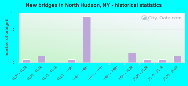
- New bridges - historical statistics
- 11920-1929
- 21930-1939
- 11950-1959
- 141960-1969
- 31990-1999
- 12000-2009
- 12010-2019
- 22020-2022

- Reconstructed bridges - Historical Statistics
- 11980-1989
- 21990-1999
- 02000-2009
- 22010-2019


- Bridge Condition - Deck
- 5.9%Excellent
- 17.6%Very good
- 23.5%Good
- 41.2%Satisfactory
- 11.8%Fair

- Bridge Condition - Superstructure
- 11.1%Excellent
- 33.3%Very good
- 22.2%Good
- 27.8%Satisfactory
- 5.6%Fair

- Bridge Condition - Substructure
- 11.1%Excellent
- 16.7%Very good
- 22.2%Good
- 33.3%Satisfactory
- 16.7%Fair

- Bridge Condition - Channel
- 5.9%Excellent
- 17.6%Very good
- 41.2%Good
- 29.4%Satisfactory
- 5.9%Poor

- Bridge Condition - Culverts
- 33.3%Excellent
- 33.3%Good
- 33.3%Satisfactory
Find on map >> Show street view
Structure Number: 100581, Location: RT 9 3 MI N N HUDSON (Lat: 43.986628, Lng: -73.716253), Route carried "on" structure: US 9, Year Built: 1957, Status: Open, Structure Length: 1.07m (3.51ft), Average Daily Traffic: 205 (year 2018), Truck Traffic: 5%, Average Future Daily Traffic: 213 (year 2040), Features Intersected: BLACK BROOK
Minimum Vertical Clearance: 30+ m (98+ ft), Kilometerpoint: 26.178, Lanes on structure: 2, Base Highway Network: Yes, Owner: State Highway Agency, Approaching Roadway Width: 13.4m (44.0ft), Material/Design: Concrete continuous, Design/Construction: Culvert, Number Of Spans In Main Unit: 2, Length of Maximum Span: 4.5m (14.8ft)
Condition: Channel: Poor, Culverts: Good, Operating Rating: 75.8 metric tons, Method Used To Determine Operating Rating: Field evaluation and documented engineering judgment, Inventory Rating: 32.7 metric tons, Method Used To Determine Inventory Rating: Field evaluation and documented engineering judgment, Structural Evaluation: Better than present minimum criteria, Waterway Adequacy: Superior to present desirable criteria, Approach Roadway Alignment: Equal to present desirable criteria, Length Of Structure Improvement: 1.06m (3.48ft), Designated Inspection Frequency: Every 24 months, Inspection Date: September 2020, Bridge Improvement Cost: $252,000, Roadway Improvement Cost: $148,000, Total Project Cost: $400,000 ( Estimate for 2021)
Find on map >> Show street view
Structure Number: 100582, Location: RT 9 5.3 MI S EXIT 30 (Lat: 44.009217, Lng: -73.697822), Route carried "on" structure: US 9, Year Built: 2014, Status: Open, Structure Length: 4.79m (15.72ft), Average Daily Traffic: 205 (year 2018), Truck Traffic: 5%, Average Future Daily Traffic: 213 (year 2040), Design Load: HL 93, Features Intersected: SCHROON RIVER
Minimum Vertical Clearance: 30+ m (98+ ft), Kilometerpoint: 29.075, Lanes on structure: 2, Base Highway Network: Yes, Owner: State Highway Agency, Approaching Roadway Width: 8.5m (27.9ft), Material/Design: Steel, Design/Construction: Stringer/Multi-beam, Number Of Spans In Main Unit: 1, Length of Maximum Span: 47.2m (154.9ft), Curb-To-Curb Width: 8.5m (27.9ft), Out-to-Out Width: 9.6m (31.5ft)
Condition: Deck: Excellent, Superstructure: Excellent, Substructure: Excellent, Channel: Good, Inventory Rating: 70.8 metric tons, Method Used To Determine Inventory Rating: Load Factor (LF), Structural Evaluation: Superior to present desirable criteria, Deck Geometry: Equal to present minimum criteria, Waterway Adequacy: Superior to present desirable criteria, Approach Roadway Alignment: Meets minimum limits, Length Of Structure Improvement: 4.78m (15.68ft), Designated Inspection Frequency: Every 24 months, Inspection Date: June 2020, Bridge Improvement Cost: $1,008,000, Roadway Improvement Cost: $590,000, Total Project Cost: $1,598,000 ( Estimate for 2021), Deck Structure Type: Concrete Cast-file-Place, Wearing Surface/Protective System: Wearing Surface: Monolithic Concrete, Deck Protection: Epoxy Coated Reinforcing
Find on map >> Show street view
Structure Number: 100583, Location: RT 9 2.7 MI S EXIT 30 (Lat: 44.043594, Lng: -73.678231), Route carried "on" structure: US 9, Year Built: 1928, Year Reconstructed: 1990, Status: Open, Structure Length: 1.34m (4.40ft), Average Daily Traffic: 205 (year 2018), Truck Traffic: 5%, Average Future Daily Traffic: 213 (year 2040), Design Load: HS 20, Features Intersected: SCHROON RIVER
Minimum Vertical Clearance: 30+ m (98+ ft), Kilometerpoint: 33.387, Lanes on structure: 2, Base Highway Network: Yes, Owner: State Highway Agency, Approaching Roadway Width: 10.1m (33.1ft), Material/Design: Steel, Design/Construction: Stringer/Multi-beam, Number Of Spans In Main Unit: 1, Length of Maximum Span: 12.1m (39.7ft), Curb-To-Curb Width: 8.5m (27.9ft), Out-to-Out Width: 9.2m (30.2ft)
Condition: Deck: Satisfactory, Superstructure: Good, Substructure: Satisfactory, Channel: Good, Inventory Rating: 92.5 metric tons, Method Used To Determine Inventory Rating: Load Factor (LF), Structural Evaluation: Equal to present minimum criteria, Deck Geometry: Equal to present minimum criteria, Waterway Adequacy: Superior to present desirable criteria, Approach Roadway Alignment: Equal to present desirable criteria, Length Of Structure Improvement: 1.34m (4.40ft), Designated Inspection Frequency: Every 24 months, Inspection Date: June 2020, Bridge Improvement Cost: $512,000, Roadway Improvement Cost: $300,000, Total Project Cost: $812,000 ( Estimate for 2021), Deck Structure Type: Concrete Cast-file-Place, Wearing Surface/Protective System: Wearing Surface: Integral Concrete, Deck Protection: Epoxy Coated Reinforcing
Find on map >> Show street view
Structure Number: 100584, Location: RT 9 1.5 MILES S EXIT 30 (Lat: 44.055303, Lng: -73.663558), Route carried "on" structure: US 9, Year Built: 1998, Status: Open, Structure Length: 2.83m (9.28ft), Average Daily Traffic: 205 (year 2018), Truck Traffic: 5%, Average Future Daily Traffic: 213 (year 2040), Design Load: HS 25 or greater, Features Intersected: SCHROON RIVER
Minimum Vertical Clearance: 30+ m (98+ ft), Kilometerpoint: 35.173, Lanes on structure: 2, Base Highway Network: Yes, Owner: State Highway Agency, Approaching Roadway Width: 10.1m (33.1ft), Skew: 3 degrees, Material/Design: Steel, Design/Construction: Stringer/Multi-beam, Number Of Spans In Main Unit: 1, Length of Maximum Span: 27.1m (88.9ft), Curb-To-Curb Width: 10.1m (33.1ft), Out-to-Out Width: 10.8m (35.4ft)
Condition: Deck: Very good, Superstructure: Very good, Substructure: Very good, Channel: Good, Operating Rating: 87.1 metric tons, Method Used To Determine Operating Rating: Load Factor (LF), Inventory Rating: 52.6 metric tons, Method Used To Determine Inventory Rating: Load Factor (LF), Structural Evaluation: Equal to present desirable criteria, Deck Geometry: Better than present minimum criteria, Waterway Adequacy: Superior to present desirable criteria, Approach Roadway Alignment: Equal to present desirable criteria, Length Of Structure Improvement: 2.83m (9.28ft), Designated Inspection Frequency: Every 24 months, Inspection Date: June 2020, Bridge Improvement Cost: $903,000, Roadway Improvement Cost: $529,000, Total Project Cost: $1,431,000 ( Estimate for 2021), Deck Structure Type: Concrete Cast-file-Place, Wearing Surface/Protective System: Wearing Surface: Integral Concrete, Deck Protection: Epoxy Coated Reinforcing
Find on map >> Show street view
Structure Number: 1005851, Location: I87 EXIT 30 (Lat: 44.076569, Lng: -73.663239), Route carried "on" structure: Interstate 87, Year Built: 1965, Status: Open, Structure Length: 3.93m (12.89ft), Average Daily Traffic: 5,870 (year 2014), Truck Traffic: 31%, Features Intersected: RTE 9
Minimum Vertical Clearance: 30+ m (98+ ft), Kilometerpoint: 37.361, Lanes on structure: 2, Lanes under structure: 4, Base Highway Network: Yes, Owner: State Highway Agency, Approaching Roadway Width: 11.9m (39.0ft), Material/Design: Steel, Design/Construction: Stringer/Multi-beam, Number Of Spans In Main Unit: 1, Length of Maximum Span: 37.7m (123.7ft), Curb-To-Curb Width: 11.8m (38.7ft), Out-to-Out Width: 12.7m (41.7ft)
Condition: Deck: Good, Superstructure: Very good, Substructure: Good, Operating Rating: 67.1 metric tons, Method Used To Determine Operating Rating: Load Factor (LF), Inventory Rating: 39.9 metric tons, Method Used To Determine Inventory Rating: Load Factor (LF), Structural Evaluation: Better than present minimum criteria, Deck Geometry: Equal to present minimum criteria, Underclear: High priority of corrective action, Approach Roadway Alignment: Equal to present desirable criteria, Length Of Structure Improvement: 3.93m (12.89ft), Designated Inspection Frequency: Every 24 months, Inspection Date: April 2021, Bridge Improvement Cost: $1,164,000, Roadway Improvement Cost: $682,000, Total Project Cost: $1,845,000 ( Estimate for 2021), Deck Structure Type: Concrete Cast-file-Place, Wearing Surface/Protective System: Wearing Surface: Epoxy Overlay
Find on map >> Show street view
Structure Number: 1005852, Location: I87 EXIT 30 (Lat: 44.076272, Lng: -73.662983), Route carried "on" structure: Interstate 87, Year Built: 1965, Status: Open, Structure Length: 3.93m (12.89ft), Average Daily Traffic: 4,009 (year 2014), Truck Traffic: 31%, Average Future Daily Traffic: 4,774 (year 2040), Features Intersected: RTE 9
Minimum Vertical Clearance: 30+ m (98+ ft), Kilometerpoint: 37.361, Lanes on structure: 2, Lanes under structure: 4, Base Highway Network: Yes, Owner: State Highway Agency, Approaching Roadway Width: 11.9m (39.0ft), Material/Design: Steel, Design/Construction: Stringer/Multi-beam, Number Of Spans In Main Unit: 1, Length of Maximum Span: 37.7m (123.7ft), Curb-To-Curb Width: 11.8m (38.7ft), Out-to-Out Width: 12.7m (41.7ft)
Condition: Deck: Good, Superstructure: Very good, Substructure: Good, Operating Rating: 67.1 metric tons, Method Used To Determine Operating Rating: Load Factor (LF), Inventory Rating: 39.9 metric tons, Method Used To Determine Inventory Rating: Load Factor (LF), Structural Evaluation: Better than present minimum criteria, Deck Geometry: Equal to present minimum criteria, Underclear: High priority of corrective action, Approach Roadway Alignment: Equal to present desirable criteria, Length Of Structure Improvement: 3.93m (12.89ft), Designated Inspection Frequency: Every 24 months, Inspection Date: April 2021, Bridge Improvement Cost: $1,134,000, Roadway Improvement Cost: $664,000, Total Project Cost: $1,798,000 ( Estimate for 2021), Deck Structure Type: Concrete Cast-file-Place, Wearing Surface/Protective System: Wearing Surface: Epoxy Overlay
Find on map >> Show street view
Structure Number: 1033701, Location: JCT I87 & BRANCH R (Lat: 43.949006, Lng: -73.740169), Route carried "on" structure: Interstate 87, Year Built: 1965, Year Reconstructed: 2017, Status: Open, Structure Length: 8.29m (27.20ft), Average Daily Traffic: 4,498 (year 2015), Truck Traffic: 24%, Design Load: HS 20+Mod, Features Intersected: BRANCH RIVER
Minimum Vertical Clearance: 30+ m (98+ ft), Kilometerpoint: 21.094, Lanes on structure: 3, Base Highway Network: Yes, Owner: State Highway Agency, Approaching Roadway Width: 13.4m (44.0ft), Skew: 3 degrees, Material/Design: Steel, Design/Construction: Stringer/Multi-beam, Number Of Spans In Main Unit: 3, Length of Maximum Span: 26.8m (87.9ft), Curb or Sidewalk Widths: Left: 0.5m (1.6ft), Right: 0.5m (1.6ft), Curb-To-Curb Width: 11.6m (38.1ft), Out-to-Out Width: 13.1m (43.0ft)
Condition: Deck: Satisfactory, Superstructure: Satisfactory, Substructure: Satisfactory, Channel: Satisfactory, Operating Rating: 82.6 metric tons, Method Used To Determine Operating Rating: Load Factor (LF), Inventory Rating: 49.0 metric tons, Method Used To Determine Inventory Rating: Load Factor (LF), Structural Evaluation: Equal to present minimum criteria, Deck Geometry: High priority of replacement, Waterway Adequacy: Superior to present desirable criteria, Approach Roadway Alignment: Equal to present desirable criteria, Length Of Structure Improvement: 8.29m (27.20ft), Designated Inspection Frequency: Every 24 months, Inspection Date: October 2021, Bridge Improvement Cost: $2,446,000, Roadway Improvement Cost: $1,432,000, Total Project Cost: $3,879,000 ( Estimate for 2021), Deck Structure Type: Concrete Cast-file-Place, Wearing Surface/Protective System: Wearing Surface: Bituminous
Find on map >> Show street view
Structure Number: 1033702, Location: JCT I87 & BRANCH R (Lat: 43.948967, Lng: -73.739631), Route carried "on" structure: Interstate 87, Year Built: 1965, Year Reconstructed: 2017, Status: Open, Structure Length: 7.65m (25.10ft), Average Daily Traffic: 3,104 (year 2015), Truck Traffic: 31%, Average Future Daily Traffic: 3,697 (year 2040), Design Load: HS 20+Mod, Features Intersected: BRANCH RIVER
Minimum Vertical Clearance: 30+ m (98+ ft), Kilometerpoint: 21.078, Lanes on structure: 2, Base Highway Network: Yes, Owner: State Highway Agency, Approaching Roadway Width: 11.6m (38.1ft), Skew: 4 degrees, Material/Design: Steel, Design/Construction: Stringer/Multi-beam, Number Of Spans In Main Unit: 3, Length of Maximum Span: 25.0m (82.0ft), Curb or Sidewalk Widths: Left: 0.5m (1.6ft), Right: 0.5m (1.6ft), Curb-To-Curb Width: 8.6m (28.2ft), Out-to-Out Width: 10.1m (33.1ft)
Condition: Deck: Satisfactory, Superstructure: Satisfactory, Substructure: Satisfactory, Channel: Satisfactory, Operating Rating: 81.6 metric tons, Method Used To Determine Operating Rating: Load Factor (LF), Inventory Rating: 49.0 metric tons, Method Used To Determine Inventory Rating: Load Factor (LF), Structural Evaluation: Equal to present minimum criteria, Deck Geometry: High priority of corrective action, Waterway Adequacy: Superior to present desirable criteria, Approach Roadway Alignment: Equal to present desirable criteria, Length Of Structure Improvement: 7.65m (25.10ft), Designated Inspection Frequency: Every 24 months, Inspection Date: October 2021, Bridge Improvement Cost: $1,764,000, Roadway Improvement Cost: $1,033,000, Total Project Cost: $2,797,000 ( Estimate for 2021), Deck Structure Type: Concrete Cast-file-Place, Wearing Surface/Protective System: Wearing Surface: Bituminous
Find on map >> Show street view
Structure Number: 1033711, Location: I87 EXIT 29 (Lat: 43.951686, Lng: -73.735867), Route carried "on" structure: Interstate 87, Year Built: 1966, Status: Open, Structure Length: 5.03m (16.50ft), Average Daily Traffic: 5,870 (year 2015), Truck Traffic: 26%, Features Intersected: RTE 910K
Minimum Vertical Clearance: 30+ m (98+ ft), Kilometerpoint: 21.545, Lanes on structure: 2, Lanes under structure: 2, Base Highway Network: Yes, Owner: State Highway Agency, Approaching Roadway Width: 12.2m (40.0ft), Skew: 3 degrees, Material/Design: Steel, Design/Construction: Stringer/Multi-beam, Number Of Spans In Main Unit: 3, Length of Maximum Span: 18.2m (59.7ft), Curb-To-Curb Width: 12.1m (39.7ft), Out-to-Out Width: 13.0m (42.7ft)
Condition: Deck: Satisfactory, Superstructure: Satisfactory, Substructure: Fair, Operating Rating: 83.5 metric tons, Method Used To Determine Operating Rating: Load Factor (LF), Inventory Rating: 49.9 metric tons, Method Used To Determine Inventory Rating: Load Factor (LF), Structural Evaluation: Somewhat better than minimum adequacy, Deck Geometry: Equal to present minimum criteria, Underclear: Somewhat better than minimum adequacy, Approach Roadway Alignment: Better than present minimum criteria, Length Of Structure Improvement: 5.02m (16.47ft), Designated Inspection Frequency: Every 24 months, Inspection Date: April 2021, Bridge Improvement Cost: $1,511,000, Roadway Improvement Cost: $885,000, Total Project Cost: $2,396,000 ( Estimate for 2021), Deck Structure Type: Concrete Cast-file-Place, Wearing Surface/Protective System: Wearing Surface: Bituminous, Membrane: Other
Find on map >> Show street view
Structure Number: 1033712, Location: I87 EXIT 29 (Lat: 43.951664, Lng: -73.735539), Route carried "on" structure: Interstate 87, Year Built: 1966, Status: Open, Structure Length: 4.91m (16.11ft), Average Daily Traffic: 4,009 (year 2015), Truck Traffic: 31%, Average Future Daily Traffic: 4,774 (year 2040), Features Intersected: RTE 910K
Minimum Vertical Clearance: 30+ m (98+ ft), Kilometerpoint: 21.545, Lanes on structure: 2, Lanes under structure: 2, Base Highway Network: Yes, Owner: State Highway Agency, Approaching Roadway Width: 12.2m (40.0ft), Skew: 3 degrees, Material/Design: Steel, Design/Construction: Stringer/Multi-beam, Number Of Spans In Main Unit: 3, Length of Maximum Span: 18.5m (60.7ft), Curb-To-Curb Width: 12.1m (39.7ft), Out-to-Out Width: 13.0m (42.7ft)
Condition: Deck: Satisfactory, Superstructure: Good, Substructure: Fair, Operating Rating: 85.3 metric tons, Method Used To Determine Operating Rating: Load Factor (LF), Inventory Rating: 50.8 metric tons, Method Used To Determine Inventory Rating: Load Factor (LF), Structural Evaluation: Somewhat better than minimum adequacy, Deck Geometry: Equal to present minimum criteria, Underclear: Somewhat better than minimum adequacy, Approach Roadway Alignment: Better than present minimum criteria, Length Of Structure Improvement: 4.90m (16.08ft), Designated Inspection Frequency: Every 24 months, Inspection Date: April 2021, Bridge Improvement Cost: $1,444,000, Roadway Improvement Cost: $845,000, Total Project Cost: $2,289,000 ( Estimate for 2021), Deck Structure Type: Concrete Cast-file-Place, Wearing Surface/Protective System: Wearing Surface: Bituminous, Membrane: Other
Find on map >> Show street view
Structure Number: 1033721, Location: I87 4.3 MI S EXIT 30 (Lat: 44.024442, Lng: -73.700711), Route carried "on" structure: Interstate 87, Year Built: 1965, Status: Open, Structure Length: 3.93m (12.89ft), Average Daily Traffic: 5,870 (year 2014), Truck Traffic: 26%, Features Intersected: WEST MILL BROOK
Minimum Vertical Clearance: 30+ m (98+ ft), Kilometerpoint: 30.362, Lanes on structure: 2, Base Highway Network: Yes, Owner: State Highway Agency, Approaching Roadway Width: 12.2m (40.0ft), Material/Design: Steel, Design/Construction: Stringer/Multi-beam, Number Of Spans In Main Unit: 1, Length of Maximum Span: 38.1m (125.0ft), Curb-To-Curb Width: 11.9m (39.0ft), Out-to-Out Width: 12.8m (42.0ft)
Condition: Deck: Fair, Superstructure: Satisfactory, Substructure: Satisfactory, Channel: Good, Operating Rating: 31.4 metric tons, Method Used To Determine Operating Rating: Load and Resistance Factor Rating (LRFR) rating reported by rating factor(RF) method using HL-93 loadings, Inventory Rating: 24.3 metric tons, Method Used To Determine Inventory Rating: Load and Resistance Factor Rating (LRFR) rating reported by rating factor(RF) method using HL-93 loadings, Structural Evaluation: Equal to present minimum criteria, Deck Geometry: Equal to present minimum criteria, Waterway Adequacy: Superior to present desirable criteria, Approach Roadway Alignment: Equal to present desirable criteria, Length Of Structure Improvement: 3.93m (12.89ft), Designated Inspection Frequency: Every 24 months, Inspection Date: April 2021, Bridge Improvement Cost: $1,199,000, Roadway Improvement Cost: $702,000, Total Project Cost: $1,901,000 ( Estimate for 2021), Deck Structure Type: Concrete Cast-file-Place, Wearing Surface/Protective System: Wearing Surface: Monolithic Concrete
Find on map >> Show street view
Structure Number: 1033722, Location: I87 4.3 MI S EXIT 30 (Lat: 44.024292, Lng: -73.699925), Route carried "on" structure: Interstate 87, Year Built: 1965, Status: Open, Structure Length: 3.93m (12.89ft), Average Daily Traffic: 4,009 (year 2014), Truck Traffic: 26%, Average Future Daily Traffic: 4,774 (year 2040), Features Intersected: WEST MILL BROOK
Minimum Vertical Clearance: 30+ m (98+ ft), Kilometerpoint: 30.378, Lanes on structure: 2, Base Highway Network: Yes, Owner: State Highway Agency, Approaching Roadway Width: 11.9m (39.0ft), Material/Design: Steel, Design/Construction: Stringer/Multi-beam, Number Of Spans In Main Unit: 1, Length of Maximum Span: 38.1m (125.0ft), Curb-To-Curb Width: 11.9m (39.0ft), Out-to-Out Width: 12.8m (42.0ft)
Condition: Deck: Fair, Superstructure: Satisfactory, Substructure: Satisfactory, Channel: Good, Operating Rating: 29.8 metric tons, Method Used To Determine Operating Rating: Load and Resistance Factor Rating (LRFR) rating reported by rating factor(RF) method using HL-93 loadings, Inventory Rating: 23.0 metric tons, Method Used To Determine Inventory Rating: Load and Resistance Factor Rating (LRFR) rating reported by rating factor(RF) method using HL-93 loadings, Structural Evaluation: Somewhat better than minimum adequacy, Deck Geometry: Equal to present minimum criteria, Waterway Adequacy: Superior to present desirable criteria, Approach Roadway Alignment: Equal to present desirable criteria, Length Of Structure Improvement: 3.93m (12.89ft), Designated Inspection Frequency: Every 24 months, Inspection Date: April 2021, Bridge Improvement Cost: $1,199,000, Roadway Improvement Cost: $702,000, Total Project Cost: $1,901,000 ( Estimate for 2021), Deck Structure Type: Concrete Cast-file-Place, Wearing Surface/Protective System: Wearing Surface: Monolithic Concrete
Find on map >> Show street view
Structure Number: 105364, Location: JCT 2B & SCROON RIVER (Lat: 43.951525, Lng: -73.734633), Route carried "on" structure: County highway 910K, Year Built: 1939, Year Reconstructed: 1994, Status: Open, Structure Length: 3.23m (10.60ft), Average Daily Traffic: 449 (year 2016), Truck Traffic: 9%, Average Future Daily Traffic: 468 (year 2040), Features Intersected: SCHROON RIVER
Minimum Vertical Clearance: 30+ m (98+ ft), Kilometerpoint: 0.418, Lanes on structure: 2, Base Highway Network: Yes, Owner: State Highway Agency, Approaching Roadway Width: 9.1m (29.9ft), Skew: 2 degrees, Material/Design: Steel, Design/Construction: Truss - Thru, Number Of Spans In Main Unit: 1, Length of Maximum Span: 31.0m (101.7ft), Curb or Sidewalk Widths: Left: 1.7m (5.6ft), Right: 1.7m (5.6ft), Curb-To-Curb Width: 7.3m (24.0ft), Out-to-Out Width: 7.8m (25.6ft)
Condition: Deck: Good, Superstructure: Fair, Substructure: Good, Channel: Satisfactory, Operating Rating: 69.9 metric tons, Method Used To Determine Operating Rating: Load Factor (LF), Inventory Rating: 43.5 metric tons, Method Used To Determine Inventory Rating: Load Factor (LF), Structural Evaluation: Somewhat better than minimum adequacy, Deck Geometry: Meets minimum limits, Waterway Adequacy: Meets minimum limits, Approach Roadway Alignment: Equal to present desirable criteria, Length Of Structure Improvement: 3.23m (10.60ft), Designated Inspection Frequency: Every 24 months, Critical Feature Inspection Frequency: Every 24 months, Inspection Date: July 2020, Critical Feature Inspection Date: July 2020, Bridge Improvement Cost: $2,553,000, Roadway Improvement Cost: $1,495,000, Total Project Cost: $4,048,000 ( Estimate for 2021), Deck Structure Type: Concrete Cast-file-Place, Wearing Surface/Protective System: Wearing Surface: Integral Concrete, Deck Protection: Epoxy Coated Reinforcing
Find on map >> Show street view
Structure Number: 330193, Location: 5 MILES N OF NORTH HUDSON (Lat: 44.017317, Lng: -73.687875), Route carried "on" structure: Other road , Year Built: 2007, Status: Open, Structure Length: 1.62m (5.31ft), Average Daily Traffic: 50 (year 2016), Truck Traffic: 6%, Average Future Daily Traffic: 70 (year 2036), Features Intersected: SCHROON RIVER, Facility Carried by Structure: GREENOUGH ROAD
Minimum Vertical Clearance: 30+ m (98+ ft), Kilometerpoint: 0.257, Lanes on structure: 1, Owner: County Highway Agency, Approaching Roadway Width: 6.1m (20.0ft), Material/Design: Steel, Design/Construction: Truss - Thru, Number Of Spans In Main Unit: 1, Length of Maximum Span: 15.2m (49.9ft), Curb-To-Curb Width: 4.3m (14.1ft), Out-to-Out Width: 4.8m (15.7ft)
Condition: Deck: Very good, Superstructure: Very good, Substructure: Very good, Channel: Satisfactory, Operating Rating: 83.5 metric tons, Method Used To Determine Operating Rating: Field evaluation and documented engineering judgment, Inventory Rating: 40.8 metric tons, Method Used To Determine Inventory Rating: Field evaluation and documented engineering judgment, Structural Evaluation: Equal to present desirable criteria, Deck Geometry: Equal to present minimum criteria, Waterway Adequacy: Meets minimum limits, Approach Roadway Alignment: Meets minimum limits, Length Of Structure Improvement: 1.61m (5.28ft), Designated Inspection Frequency: Every 24 months, Critical Feature Inspection Frequency: Every 24 months, Inspection Date: June 2021, Critical Feature Inspection Date: June 2021, Bridge Improvement Cost: $491,000, Roadway Improvement Cost: $288,000, Total Project Cost: $779,000 ( Estimate for 2021), Deck Structure Type: Steel plate, Wearing Surface/Protective System: Wearing Surface: Other
Find on map >> Show street view
Structure Number: 330194, Location: 3 MI NE NORTH HUDSON (Lat: 43.991103, Lng: -73.687997), Route carried "on" structure: County highway , Year Built: 1932, Year Reconstructed: 1997, Status: Posted for load-capacity, Structure Length: 1.34m (4.40ft), Average Daily Traffic: 201 (year 2015), Truck Traffic: 10%, Average Future Daily Traffic: 209 (year 2040), Features Intersected: BLACK BROOK, Facility Carried by Structure: N HUDSN MORIAH RD
Minimum Vertical Clearance: 30+ m (98+ ft), Kilometerpoint: 2.590, Lanes on structure: 2, Owner: County Highway Agency, Approaching Roadway Width: 5.5m (18.0ft), Material/Design: Wood or Timber, Design/Construction: Slab, Number Of Spans In Main Unit: 1, Length of Maximum Span: 12.4m (40.7ft), Curb-To-Curb Width: 6.2m (20.3ft), Out-to-Out Width: 7.1m (23.3ft)
Condition: Deck: Very good, Superstructure: Very good, Substructure: Satisfactory, Channel: Very good, Operating Rating: 59.5 metric tons, Method Used To Determine Operating Rating: Field evaluation and documented engineering judgment, Inventory Rating: 24.9 metric tons, Method Used To Determine Inventory Rating: Field evaluation and documented engineering judgment, Structural Evaluation: Equal to present minimum criteria, Deck Geometry: Meets minimum limits, Waterway Adequacy: Meets minimum limits, Approach Roadway Alignment: Meets minimum limits, Length Of Structure Improvement: 1.34m (4.40ft), Designated Inspection Frequency: Every 24 months, Inspection Date: June 2020, Bridge Improvement Cost: $273,000, Roadway Improvement Cost: $160,000, Total Project Cost: $433,000 ( Estimate for 2021), Wearing Surface/Protective System: Wearing Surface: Bituminous
Find on map >> Show street view
Structure Number: 330195, Location: 5 MI NE I87 EXIT 29 (Lat: 43.993583, Lng: -73.659628), Route carried "on" structure: County highway , Year Built: 1995, Status: Posted for load-capacity, Structure Length: 0.91m (2.99ft), Average Daily Traffic: 201 (year 2015), Truck Traffic: 10%, Average Future Daily Traffic: 209 (year 2040), Design Load: HS 20, Features Intersected: BLACK BROOK, Facility Carried by Structure: COUNTY ROAD 4
Minimum Vertical Clearance: 30+ m (98+ ft), Kilometerpoint: 5.181, Lanes on structure: 2, Owner: County Highway Agency, Approaching Roadway Width: 7.0m (23.0ft), Material/Design: Wood or Timber, Design/Construction: Slab, Number Of Spans In Main Unit: 1, Length of Maximum Span: 8.5m (27.9ft), Curb-To-Curb Width: 7.0m (23.0ft), Out-to-Out Width: 7.4m (24.3ft)
Condition: Deck: Satisfactory, Superstructure: Good, Substructure: Fair, Channel: Good, Operating Rating: 45.4 metric tons, Method Used To Determine Operating Rating: Allowable Stress (AS), Inventory Rating: 29.9 metric tons, Method Used To Determine Inventory Rating: Allowable Stress (AS), Structural Evaluation: Somewhat better than minimum adequacy, Deck Geometry: Meets minimum limits, Waterway Adequacy: Somewhat better than minimum adequacy, Approach Roadway Alignment: Meets minimum limits, Length Of Structure Improvement: 0.91m (2.99ft), Designated Inspection Frequency: Every 24 months, Inspection Date: July 2021, Bridge Improvement Cost: $384,000, Roadway Improvement Cost: $225,000, Total Project Cost: $609,000 ( Estimate for 2021), Wearing Surface/Protective System: Wearing Surface: Bituminous
Find on map >> Show street view
Structure Number: 330196, Location: 4.5 MI NE OF NORTH HUDSON (Lat: 44.013283, Lng: -73.701581), Route carried "on" structure: Other road , Year Built: 1996, Status: Open, Structure Length: 1.22m (4.00ft), Average Daily Traffic: 91 (year 2016), Truck Traffic: 6%, Average Future Daily Traffic: 127 (year 2036), Design Load: HS 20, Features Intersected: WEST MILL BROOK, Facility Carried by Structure: PEPPER HOLLOW ROAD
Minimum Vertical Clearance: 30+ m (98+ ft), Kilometerpoint: 0.611, Lanes on structure: 2, Owner: County Highway Agency, Approaching Roadway Width: 4.9m (16.1ft), Material/Design: Wood or Timber, Design/Construction: Slab, Number Of Spans In Main Unit: 1, Length of Maximum Span: 11.5m (37.7ft), Curb-To-Curb Width: 4.9m (16.1ft), Out-to-Out Width: 5.3m (17.4ft)
Condition: Deck: Good, Superstructure: Very good, Substructure: Very good, Channel: Good, Operating Rating: 53.5 metric tons, Method Used To Determine Operating Rating: Allowable Stress (AS), Inventory Rating: 39.9 metric tons, Method Used To Determine Inventory Rating: Allowable Stress (AS), Structural Evaluation: Equal to present desirable criteria, Deck Geometry: High priority of corrective action, Waterway Adequacy: Superior to present desirable criteria, Approach Roadway Alignment: Equal to present desirable criteria, Length Of Structure Improvement: 1.21m (3.97ft), Designated Inspection Frequency: Every 24 months, Inspection Date: August 2021, Bridge Improvement Cost: $205,000, Roadway Improvement Cost: $120,000, Total Project Cost: $325,000 ( Estimate for 2021), Deck Structure Type: Wood or Timber, Wearing Surface/Protective System: Wearing Surface: Bituminous
Find on map >> Show street view
Structure Number: 330264, Location: .5 MI E OF EXIT 30 - I87 (Lat: 44.076017, Lng: -73.659442), Route carried "on" structure: County highway , Year Built: 2021, Status: Open, Structure Length: 1.01m (3.31ft), Average Daily Traffic: 211 (year 2020), Truck Traffic: 7%, Average Future Daily Traffic: 295 (year 2040), Features Intersected: NEW POND BROOK, Facility Carried by Structure: CR 6
Minimum Vertical Clearance: 30+ m (98+ ft), Kilometerpoint: 0.821, Lanes on structure: 2, Owner: County Highway Agency, Approaching Roadway Width: 8.5m (27.9ft), Skew: 3 degrees, Material/Design: Concrete, Design/Construction: Frame, Number Of Spans In Main Unit: 1, Length of Maximum Span: 9.1m (29.9ft), Curb-To-Curb Width: 8.5m (27.9ft), Out-to-Out Width: 9.5m (31.2ft)
Condition: Superstructure: Excellent, Substructure: Excellent, Channel: Excellent, Inventory Rating: 61.7 metric tons, Method Used To Determine Inventory Rating: Load Factor (LF), Structural Evaluation: Superior to present desirable criteria, Deck Geometry: Equal to present minimum criteria, Waterway Adequacy: Meets minimum limits, Approach Roadway Alignment: Meets minimum limits, Length Of Structure Improvement: 0.91m (2.99ft), Designated Inspection Frequency: Every 24 months, Inspection Date: October 2021, Bridge Improvement Cost: $304,000, Roadway Improvement Cost: $178,000, Total Project Cost: $482,000 ( Estimate for 2021)
Find on map >> Show street view
Structure Number: 330265, Location: BOREAS ROAD IN NO. HUDSON (Lat: 43.954464, Lng: -73.836342), Route carried "on" structure: County highway , Year Built: 1965, Status: Open, Structure Length: 2.01m (6.59ft), Average Daily Traffic: 191 (year 2018), Truck Traffic: 19%, Average Future Daily Traffic: 199 (year 2040), Features Intersected: TRIB BRANCH RIVER, Facility Carried by Structure: COUNTY ROAD 2
Minimum Vertical Clearance: 30+ m (98+ ft), Kilometerpoint: 21.384, Lanes on structure: 2, Owner: County Highway Agency, Approaching Roadway Width: 8.2m (26.9ft), Material/Design: Steel, Design/Construction: Stringer/Multi-beam, Number Of Spans In Main Unit: 1, Length of Maximum Span: 19.5m (64.0ft), Curb-To-Curb Width: 7.3m (24.0ft), Out-to-Out Width: 8.8m (28.9ft)
Condition: Deck: Satisfactory, Superstructure: Good, Substructure: Good, Channel: Very good, Operating Rating: 55.4 metric tons, Method Used To Determine Operating Rating: Load and Resistance Factor Rating (LRFR) rating reported by rating factor(RF) method using HL-93 loadings, Inventory Rating: 42.4 metric tons, Method Used To Determine Inventory Rating: Load and Resistance Factor Rating (LRFR) rating reported by rating factor(RF) method using HL-93 loadings, Structural Evaluation: Better than present minimum criteria, Deck Geometry: Somewhat better than minimum adequacy, Waterway Adequacy: Equal to present minimum criteria, Approach Roadway Alignment: Equal to present desirable criteria, Length Of Structure Improvement: 2.01m (6.59ft), Designated Inspection Frequency: Every 24 months, Inspection Date: August 2020, Bridge Improvement Cost: $766,000, Roadway Improvement Cost: $449,000, Total Project Cost: $1,215,000 ( Estimate for 2021), Deck Structure Type: Concrete Cast-file-Place, Wearing Surface/Protective System: Wearing Surface: Bituminous
Find on map >> Show street view
Structure Number: 330267, Location: IN BLUE RIDGE (Lat: 43.958367, Lng: -73.790328), Route carried "on" structure: County highway , Year Built: 1965, Status: Open, Structure Length: 0.85m (2.79ft), Average Daily Traffic: 191 (year 2018), Truck Traffic: 19%, Average Future Daily Traffic: 199 (year 2040), Features Intersected: NIAGARA BROOK, Facility Carried by Structure: BOREAS ROAD
Minimum Vertical Clearance: 30+ m (98+ ft), Kilometerpoint: 25.583, Lanes on structure: 2, Owner: County Highway Agency, Approaching Roadway Width: 9.1m (29.9ft), Skew: 2 degrees, Material/Design: Concrete continuous, Design/Construction: Culvert, Number Of Spans In Main Unit: 2, Length of Maximum Span: 3.9m (12.8ft)
Condition: Channel: Satisfactory, Culverts: Satisfactory, Operating Rating: 23.7 metric tons, Method Used To Determine Operating Rating: Load and Resistance Factor Rating (LRFR) rating reported by rating factor(RF) method using HL-93 loadings, Inventory Rating: 18.1 metric tons, Method Used To Determine Inventory Rating: Load and Resistance Factor Rating (LRFR) rating reported by rating factor(RF) method using HL-93 loadings, Structural Evaluation: Somewhat better than minimum adequacy, Waterway Adequacy: Equal to present minimum criteria, Approach Roadway Alignment: Better than present minimum criteria, Length Of Structure Improvement: 0.85m (2.79ft), Designated Inspection Frequency: Every 24 months, Inspection Date: July 2020, Bridge Improvement Cost: $372,000, Roadway Improvement Cost: $218,000, Total Project Cost: $590,000 ( Estimate for 2021), Wearing Surface/Protective System: Wearing Surface: Bituminous
Find on map >> Show street view
Structure Number: 337178, Location: .5 MI E OF EXIT 30 - I87 (Lat: 44.076147, Lng: -73.652850), Route carried "on" structure: County highway , Year Built: 2021, Status: Open, Structure Length: 0.98m (3.22ft), Average Daily Traffic: 211 (year 2020), Truck Traffic: 7%, Average Future Daily Traffic: 295 (year 2040), Design Load: HL 93, Features Intersected: Ash Craft Brook, Facility Carried by Structure: Tracy Road
Minimum Vertical Clearance: 32.69m (107.25ft), Kilometerpoint: 0.837, Lanes on structure: 2, Owner: County Highway Agency, Approaching Roadway Width: 7.6m (24.9ft), Skew: 1 degrees, Material/Design: Concrete, Design/Construction: Culvert, Number Of Spans In Main Unit: 1, Length of Maximum Span: 9.1m (29.9ft)
Condition: Channel: Very good, Culverts: Excellent, Inventory Rating: 81.6 metric tons, Method Used To Determine Inventory Rating: Load Factor (LF), Structural Evaluation: Superior to present desirable criteria, Waterway Adequacy: Meets minimum limits, Approach Roadway Alignment: Equal to present desirable criteria, Designated Inspection Frequency: Every 24 months, Inspection Date: November 2021
Find on map >> Show street view
Structure Number: 1005851, Location: I87 EXIT 30 (Lat: 44.076569, Lng: -73.663239), Route carried "under" structure: US 9, Year Built: 1965, Structure Length: 0. m, Average Daily Traffic: 2,475 (year 1998), Features Intersected: RTE 9, Facility Carried by Structure: RTE I87
Minimum Vertical Clearance: 4.77m (15.65ft), Kilometerpoint: 37.812, Lanes on structure: 2, Lanes under structure: 4, Material/Design: Steel, Design/Construction: Stringer/Multi-beam, Length of Maximum Span: 37.7m (123.7ft)
Find on map >> Show street view
Structure Number: 1005852, Location: I87 EXIT 30 (Lat: 44.076272, Lng: -73.662983), Route carried "under" structure: US 9, Year Built: 1965, Structure Length: 0. m, Average Daily Traffic: 2,475 (year 1998), Features Intersected: RTE 9, Facility Carried by Structure: RTE I87
Minimum Vertical Clearance: 5.00m (16.40ft), Kilometerpoint: 37.828, Lanes on structure: 2, Lanes under structure: 4, Material/Design: Steel, Design/Construction: Stringer/Multi-beam, Length of Maximum Span: 37.7m (123.7ft)
Find on map >> Show street view
Structure Number: 1033711, Location: I87 EXIT 29 (Lat: 43.951686, Lng: -73.735867), Route carried "under" structure: State highway 910K, Year Built: 1966, Structure Length: 0. m, Average Daily Traffic: 350 (year 2021), Features Intersected: RTE 910K, Facility Carried by Structure: RTE I87
Minimum Vertical Clearance: 4.74m (15.55ft), Kilometerpoint: 3.009, Lanes on structure: 2, Lanes under structure: 2, Material/Design: Steel, Design/Construction: Stringer/Multi-beam, Length of Maximum Span: 18.2m (59.7ft)
Find on map >> Show street view
Structure Number: 1033712, Location: I87 EXIT 29 (Lat: 43.951664, Lng: -73.735539), Route carried "under" structure: State highway 910K, Year Built: 1966, Structure Length: 0. m, Average Daily Traffic: 350 (year 2021), Features Intersected: RTE 910K, Facility Carried by Structure: RTE I87
Minimum Vertical Clearance: 4.85m (15.91ft), Kilometerpoint: 3.041, Lanes on structure: 2, Lanes under structure: 2, Material/Design: Steel, Design/Construction: Stringer/Multi-beam, Length of Maximum Span: 18.5m (60.7ft)