Bridge Statistics for Murray, New York (NY)
Condition, Traffic, Stress, Structural Evaluation, Project Costs
- National Bridge Inventory (NBI) Statistics
- 18Number of bridges
- 262ft / 80.1mTotal length
- $45,206,000Total costs
- 15,739Total average daily traffic
- 1,075Total average daily truck traffic
- 18,424Total future (year 2036) average daily traffic
- National Bridge Inventory (NBI) Registered Bridges for Murray
- No street view available for this location
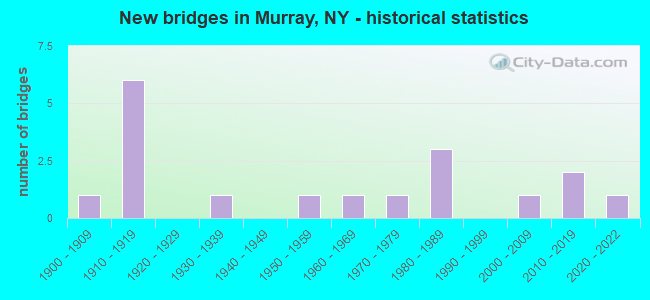
- New bridges - historical statistics
- 11900-1909
- 61910-1919
- 11930-1939
- 11950-1959
- 11960-1969
- 11970-1979
- 31980-1989
- 12000-2009
- 22010-2019
- 12020-2022

- Reconstructed bridges - Historical Statistics
- 11980-1989
- 11990-1999
- 02000-2009
- 12010-2019
- 22020-2022


- Bridge Condition - Deck
- 18.8%Excellent
- 25.0%Very good
- 6.3%Good
- 18.8%Satisfactory
- 18.8%Fair
- 6.3%Poor
- 6.3%Failed

- Bridge Condition - Superstructure
- 18.8%Excellent
- 25.0%Very good
- 6.3%Good
- 31.3%Satisfactory
- 6.3%Fair
- 6.3%Serious
- 6.3%Failed

- Bridge Condition - Substructure
- 12.5%Excellent
- 6.3%Very good
- 43.8%Good
- 12.5%Satisfactory
- 12.5%Fair
- 6.3%Poor
- 6.3%Critical

- Bridge Condition - Channel
- 17.6%Excellent
- 11.8%Very good
- 41.2%Good
- 17.6%Satisfactory
- 11.8%Fair
Find on map >> Show street view
Structure Number: 102156, Location: WEST SIDE OF HOLLEY (Lat: 43.226294, Lng: -78.037769), Route carried "on" structure: State highway 31, Year Built: 1976, Status: Open, Structure Length: 9.48m (31.10ft), Average Daily Traffic: 2,389 (year 2020), Truck Traffic: 7%, Average Future Daily Traffic: 2,400 (year 2040), Design Load: HS 20, Features Intersected: FALLS ROAD RR
Minimum Vertical Clearance: 30+ m (98+ ft), Kilometerpoint: 38.165, Lanes on structure: 2, Base Highway Network: Yes, Owner: State Highway Agency, Approaching Roadway Width: 9.8m (32.2ft), Material/Design: Steel continuous, Design/Construction: Stringer/Multi-beam, Number Of Spans In Main Unit: 5, Length of Maximum Span: 42.6m (139.8ft), Curb or Sidewalk Widths: Left: 0.0m, Right: 1.8m (5.9ft), Curb-To-Curb Width: 9.9m (32.5ft), Out-to-Out Width: 12.2m (40.0ft)
Condition: Deck: Fair, Superstructure: Satisfactory, Substructure: Satisfactory, Operating Rating: 64.4 metric tons, Method Used To Determine Operating Rating: Load Factor (LF), Inventory Rating: 38.1 metric tons, Method Used To Determine Inventory Rating: Load Factor (LF), Structural Evaluation: Equal to present minimum criteria, Deck Geometry: Meets minimum limits, Underclear: Meets minimum limits, Approach Roadway Alignment: Equal to present desirable criteria, Length Of Structure Improvement: 9.47m (31.07ft), Designated Inspection Frequency: Every 24 months, Inspection Date: July 2021, Bridge Improvement Cost: $2,419,000, Roadway Improvement Cost: $1,417,000, Total Project Cost: $3,836,000 ( Estimate for 2021), Deck Structure Type: Concrete Cast-file-Place, Wearing Surface/Protective System: Wearing Surface: Bituminous
Find on map >> Show street view
Structure Number: 103644, Location: JCT RTE 104 + SANDY CK (Lat: 43.275044, Lng: -78.050631), Route carried "on" structure: State highway 104, Year Built: 1960, Status: Open, Structure Length: 1.71m (5.61ft), Average Daily Traffic: 4,314 (year 2019), Truck Traffic: 9%, Average Future Daily Traffic: 4,354 (year 2040), Features Intersected: SANDY CREEK
Minimum Vertical Clearance: 30+ m (98+ ft), Kilometerpoint: 34.770, Lanes on structure: 2, Base Highway Network: Yes, Owner: State Highway Agency, Approaching Roadway Width: 14.3m (46.9ft), Material/Design: Concrete continuous, Design/Construction: Culvert, Number Of Spans In Main Unit: 3, Length of Maximum Span: 5.1m (16.7ft)
Condition: Channel: Good, Culverts: Very good, Operating Rating: 76.2 metric tons, Method Used To Determine Operating Rating: Field evaluation and documented engineering judgment, Inventory Rating: 32.7 metric tons, Method Used To Determine Inventory Rating: Field evaluation and documented engineering judgment, Structural Evaluation: Equal to present desirable criteria, Waterway Adequacy: High priority of corrective action, Approach Roadway Alignment: Equal to present minimum criteria, Length Of Structure Improvement: 1.70m (5.58ft), Designated Inspection Frequency: Every 24 months, Inspection Date: September 2020, Bridge Improvement Cost: $954,000, Roadway Improvement Cost: $559,000, Total Project Cost: $1,513,000 ( Estimate for 2021)
Find on map >> Show street view
Structure Number: 104241, Location: .1 MI S JCT SH104 & SH237 (Lat: 43.265772, Lng: -78.031406), Route carried "on" structure: State highway 237, Year Built: 1954, Status: Open, Structure Length: 1.43m (4.69ft), Average Daily Traffic: 1,372 (year 2017), Truck Traffic: 5%, Average Future Daily Traffic: 1,431 (year 2040), Features Intersected: E BRN SANDY CREEK
Minimum Vertical Clearance: 30+ m (98+ ft), Kilometerpoint: 16.428, Lanes on structure: 2, Base Highway Network: Yes, Owner: State Highway Agency, Approaching Roadway Width: 11.0m (36.1ft), Skew: 2 degrees, Material/Design: Steel, Design/Construction: Stringer/Multi-beam, Number Of Spans In Main Unit: 1, Length of Maximum Span: 13.4m (44.0ft), Curb-To-Curb Width: 7.9m (25.9ft), Out-to-Out Width: 10.1m (33.1ft)
Condition: Deck: Fair, Superstructure: Satisfactory, Substructure: Satisfactory, Channel: Fair, Operating Rating: 41.5 metric tons, Method Used To Determine Operating Rating: Load and Resistance Factor Rating (LRFR) rating reported by rating factor(RF) method using HL-93 loadings, Inventory Rating: 32.1 metric tons, Method Used To Determine Inventory Rating: Load and Resistance Factor Rating (LRFR) rating reported by rating factor(RF) method using HL-93 loadings, Structural Evaluation: Equal to present minimum criteria, Deck Geometry: Meets minimum limits, Waterway Adequacy: Equal to present minimum criteria, Approach Roadway Alignment: Better than present minimum criteria, Length Of Structure Improvement: 1.43m (4.69ft), Designated Inspection Frequency: Every 24 months, Inspection Date: July 2020, Bridge Improvement Cost: $548,000, Roadway Improvement Cost: $321,000, Total Project Cost: $868,000 ( Estimate for 2021), Deck Structure Type: Concrete Cast-file-Place, Wearing Surface/Protective System: Wearing Surface: Bituminous, Deck Protection: Other Coated Reinforcing
Find on map >> Show street view
Structure Number: 33192, Location: 2.3 MI NE OF HOLLEY (Lat: 43.257531, Lng: -78.008367), Route carried "on" structure: County highway , Year Built: 1989, Status: Open, Structure Length: 2.65m (8.69ft), Average Daily Traffic: 751 (year 2017), Truck Traffic: 5%, Average Future Daily Traffic: 1,051 (year 2037), Design Load: HS 20, Features Intersected: E BR SANDY CREEK, Facility Carried by Structure: HURD RD CR 42
Minimum Vertical Clearance: 30+ m (98+ ft), Kilometerpoint: 1.496, Lanes on structure: 2, Owner: County Highway Agency, Approaching Roadway Width: 8.8m (28.9ft), Skew: 1 degrees, Material/Design: Prestressed concrete, Design/Construction: Box Beam or Girders - Multiple, Number Of Spans In Main Unit: 1, Length of Maximum Span: 25.6m (84.0ft), Curb-To-Curb Width: 9.1m (29.9ft), Out-to-Out Width: 9.8m (32.2ft)
Condition: Deck: Satisfactory, Superstructure: Satisfactory, Substructure: Very good, Channel: Satisfactory, Operating Rating: 70.6 metric tons, Method Used To Determine Operating Rating: Load and Resistance Factor Rating (LRFR) rating reported by rating factor(RF) method using HL-93 loadings, Inventory Rating: 54.4 metric tons, Method Used To Determine Inventory Rating: Load and Resistance Factor Rating (LRFR) rating reported by rating factor(RF) method using HL-93 loadings, Structural Evaluation: Equal to present minimum criteria, Deck Geometry: Equal to present minimum criteria, Waterway Adequacy: Superior to present desirable criteria, Approach Roadway Alignment: Better than present minimum criteria, Length Of Structure Improvement: 2.65m (8.69ft), Designated Inspection Frequency: Every 24 months, Inspection Date: July 2020, Bridge Improvement Cost: $526,000, Roadway Improvement Cost: $308,000, Total Project Cost: $834,000 ( Estimate for 2021), Wearing Surface/Protective System: Wearing Surface: Bituminous, Membrane: Other
Find on map >> Show street view
Structure Number: 331921, Location: .1 MILE SOUTH OF MURRAY (Lat: 43.272225, Lng: -78.046369), Route carried "on" structure: Other road , Year Built: 1934, Status: Open, Structure Length: 1.19m (3.90ft), Average Daily Traffic: 296 (year 2020), Truck Traffic: 5%, Average Future Daily Traffic: 414 (year 2040), Features Intersected: E BR SANDY CREEK, Facility Carried by Structure: GROTH ROAD
Minimum Vertical Clearance: 30+ m (98+ ft), Kilometerpoint: 3.073, Lanes on structure: 2, Owner: County Highway Agency, Approaching Roadway Width: 4.9m (16.1ft), Material/Design: Steel, Design/Construction: Stringer/Multi-beam, Number Of Spans In Main Unit: 1, Length of Maximum Span: 11.5m (37.7ft), Curb-To-Curb Width: 7.3m (24.0ft), Out-to-Out Width: 8.3m (27.2ft)
Condition: Deck: Poor, Superstructure: Satisfactory, Substructure: Fair, Channel: Satisfactory, Operating Rating: 64.4 metric tons, Method Used To Determine Operating Rating: Load Factor (LF), Inventory Rating: 39.0 metric tons, Method Used To Determine Inventory Rating: Load Factor (LF), Structural Evaluation: Somewhat better than minimum adequacy, Deck Geometry: Somewhat better than minimum adequacy, Waterway Adequacy: Equal to present desirable criteria, Approach Roadway Alignment: Equal to present desirable criteria, Length Of Structure Improvement: 1.18m (3.87ft), Designated Inspection Frequency: Every 24 months, Inspection Date: April 2020, Bridge Improvement Cost: $354,000, Roadway Improvement Cost: $208,000, Total Project Cost: $562,000 ( Estimate for 2021), Deck Structure Type: Concrete Cast-file-Place, Wearing Surface/Protective System: Wearing Surface: Bituminous
Find on map >> Show street view
Structure Number: 331922, Location: 0.6 MI WEST OF MURRAY (Lat: 43.274961, Lng: -78.056944), Route carried "on" structure: Alternate County highway , Year Built: 2014, Status: Open, Structure Length: 1.16m (3.81ft), Average Daily Traffic: 485 (year 2016), Truck Traffic: 7%, Average Future Daily Traffic: 679 (year 2036), Design Load: HL 93, Features Intersected: W BR SANDY CREEK, Facility Carried by Structure: HULBERTON ROAD
Minimum Vertical Clearance: 30+ m (98+ ft), Kilometerpoint: 1.094, Lanes on structure: 2, Owner: County Highway Agency, Approaching Roadway Width: 9.1m (29.9ft), Material/Design: Concrete, Design/Construction: Culvert, Number Of Spans In Main Unit: 1, Length of Maximum Span: 11.0m (36.1ft)
Condition: Channel: Good, Culverts: Very good, Operating Rating: 80.4 metric tons, Method Used To Determine Operating Rating: Field evaluation and documented engineering judgment, Inventory Rating: 40.8 metric tons, Method Used To Determine Inventory Rating: Field evaluation and documented engineering judgment, Structural Evaluation: Equal to present desirable criteria, Waterway Adequacy: Equal to present minimum criteria, Approach Roadway Alignment: Somewhat better than minimum adequacy, Length Of Structure Improvement: 1.15m (3.77ft), Designated Inspection Frequency: Every 24 months, Inspection Date: November 2020, Bridge Improvement Cost: $340,000, Roadway Improvement Cost: $199,000, Total Project Cost: $539,000 ( Estimate for 2021)
Find on map >> Show street view
Structure Number: 331923, Location: 0.9 MI NW BROCKVILLE (Lat: 43.263719, Lng: -78.105567), Route carried "on" structure: Other road , Year Built: 1900, Year Reconstructed: 1992, Status: Open, Structure Length: 1.01m (3.31ft), Average Daily Traffic: 26 (year 2020), Truck Traffic: 5%, Average Future Daily Traffic: 36 (year 2040), Features Intersected: W BR SANDY CREEK, Facility Carried by Structure: HINDSBURG ROAD
Minimum Vertical Clearance: 30+ m (98+ ft), Kilometerpoint: 4.119, Lanes on structure: 2, Owner: County Highway Agency, Approaching Roadway Width: 7.0m (23.0ft), Skew: 1 degrees, Material/Design: Steel, Design/Construction: Stringer/Multi-beam, Number Of Spans In Main Unit: 1, Length of Maximum Span: 8.8m (28.9ft), Curb-To-Curb Width: 8.0m (26.2ft), Out-to-Out Width: 9.1m (29.9ft)
Condition: Deck: Fair, Superstructure: Fair, Substructure: Fair, Channel: Fair, Operating Rating: 67.1 metric tons, Method Used To Determine Operating Rating: Load Factor (LF), Inventory Rating: 39.9 metric tons, Method Used To Determine Inventory Rating: Load Factor (LF), Structural Evaluation: Somewhat better than minimum adequacy, Deck Geometry: Equal to present minimum criteria, Waterway Adequacy: Equal to present desirable criteria, Approach Roadway Alignment: Equal to present desirable criteria, Length Of Structure Improvement: 1.00m (3.28ft), Designated Inspection Frequency: Every 24 months, Inspection Date: April 2020, Bridge Improvement Cost: $378,000, Roadway Improvement Cost: $221,000, Total Project Cost: $600,000 ( Estimate for 2021), Deck Structure Type: Open Grating, Wearing Surface/Protective System: Wearing Surface: Other
Find on map >> Show street view
Structure Number: 331924, Location: 1.3 MI NE OF BROCKVILLE (Lat: 43.264714, Lng: -78.115500), Route carried "on" structure: County highway , Year Built: 2021, Status: Open, Structure Length: 2.10m (6.89ft), Average Daily Traffic: 270 (year 2016), Truck Traffic: 5%, Average Future Daily Traffic: 378 (year 2036), Design Load: HL 93, Features Intersected: W BR SANDY CREEK, Facility Carried by Structure: TRANSIT ROAD
Minimum Vertical Clearance: 32.69m (107.25ft), Kilometerpoint: 2.301, Lanes on structure: 2, Owner: County Highway Agency, Approaching Roadway Width: 6.7m (22.0ft), Skew: 2 degrees, Material/Design: Steel, Design/Construction: Stringer/Multi-beam, Number Of Spans In Main Unit: 1, Length of Maximum Span: 20.7m (67.9ft), Curb-To-Curb Width: 7.9m (25.9ft), Out-to-Out Width: 8.9m (29.2ft)
Condition: Deck: Excellent, Superstructure: Excellent, Substructure: Critical, Channel: Satisfactory, Operating Rating: 76.2 metric tons, Method Used To Determine Operating Rating: Load Factor (LF), Inventory Rating: 45.4 metric tons, Method Used To Determine Inventory Rating: Load Factor (LF), Structural Evaluation: High priority of replacement, Deck Geometry: Somewhat better than minimum adequacy, Waterway Adequacy: Superior to present desirable criteria, Approach Roadway Alignment: Equal to present desirable criteria, Designated Inspection Frequency: Every 24 months, Inspection Date: December 2021, Deck Structure Type: Concrete Cast-file-Place, Wearing Surface/Protective System: Wearing Surface: Integral Concrete, Deck Protection: Epoxy Coated Reinforcing
Find on map >> Show street view
Structure Number: 331941, Location: 3.3 MILES NE OF HOLLEY (Lat: 43.254383, Lng: -77.996556), Route carried "on" structure: County highway , Year Built: 2007, Status: Open, Structure Length: 2.41m (7.91ft), Average Daily Traffic: 751 (year 2017), Truck Traffic: 6%, Average Future Daily Traffic: 1,051 (year 2037), Design Load: HL 93, Features Intersected: SANDY CREEK, Facility Carried by Structure: ORL MNROE C LN RD
Minimum Vertical Clearance: 30+ m (98+ ft), Kilometerpoint: 2.027, Lanes on structure: 2, Owner: County Highway Agency, Approaching Roadway Width: 9.1m (29.9ft), Skew: 3 degrees, Material/Design: Prestressed concrete, Design/Construction: Box Beam or Girders - Multiple, Number Of Spans In Main Unit: 1, Length of Maximum Span: 23.5m (77.1ft), Curb-To-Curb Width: 9.0m (29.5ft), Out-to-Out Width: 9.8m (32.2ft)
Condition: Deck: Very good, Superstructure: Excellent, Substructure: Excellent, Channel: Good, Operating Rating: 99.8 metric tons, Method Used To Determine Operating Rating: Load Factor (LF), Inventory Rating: 59.0 metric tons, Method Used To Determine Inventory Rating: Load Factor (LF), Structural Evaluation: Superior to present desirable criteria, Deck Geometry: Somewhat better than minimum adequacy, Waterway Adequacy: Better than present minimum criteria, Approach Roadway Alignment: Equal to present minimum criteria, Length Of Structure Improvement: 2.40m (7.87ft), Designated Inspection Frequency: Every 24 months, Inspection Date: April 2021, Bridge Improvement Cost: $535,000, Roadway Improvement Cost: $313,000, Total Project Cost: $848,000 ( Estimate for 2021), Deck Structure Type: Concrete Cast-file-Place, Wearing Surface/Protective System: Wearing Surface: Integral Concrete, Deck Protection: Epoxy Coated Reinforcing
Find on map >> Show street view
Structure Number: 331942, Location: 2.9 MILES NW OF ALABAMA (Lat: 43.240056, Lng: -77.996744), Route carried "on" structure: County highway , Year Built: 2019, Status: Open, Structure Length: 2.59m (8.50ft), Average Daily Traffic: 751 (year 2017), Truck Traffic: 6%, Average Future Daily Traffic: 1,051 (year 2037), Design Load: HL 93, Features Intersected: E BR SANDY CREEK, Facility Carried by Structure: MONROE-ORLEANS CO
Minimum Vertical Clearance: 30+ m (98+ ft), Kilometerpoint: 0.434, Lanes on structure: 2, Owner: County Highway Agency, Approaching Roadway Width: 8.8m (28.9ft), Skew: 3 degrees, Material/Design: Prestressed concrete, Design/Construction: Box Beam or Girders - Multiple, Number Of Spans In Main Unit: 1, Length of Maximum Span: 25.0m (82.0ft), Curb-To-Curb Width: 8.5m (27.9ft), Out-to-Out Width: 9.5m (31.2ft)
Condition: Deck: Excellent, Superstructure: Excellent, Substructure: Excellent, Channel: Very good, Operating Rating: 76.2 metric tons, Method Used To Determine Operating Rating: Load Factor (LF), Inventory Rating: 45.4 metric tons, Method Used To Determine Inventory Rating: Load Factor (LF), Structural Evaluation: Superior to present desirable criteria, Deck Geometry: Somewhat better than minimum adequacy, Waterway Adequacy: Better than present minimum criteria, Approach Roadway Alignment: Equal to present desirable criteria, Length Of Structure Improvement: 2.59m (8.50ft), Designated Inspection Frequency: Every 24 months, Inspection Date: September 2021, Bridge Improvement Cost: $507,000, Roadway Improvement Cost: $297,000, Total Project Cost: $803,000 ( Estimate for 2021), Deck Structure Type: Concrete Cast-file-Place, Wearing Surface/Protective System: Wearing Surface: Integral Concrete, Deck Protection: Epoxy Coated Reinforcing
Find on map >> Show street view
Structure Number: 444501, Location: 1.1MI E JCT BARGE C+237 (Lat: 43.224778, Lng: -78.013953), Route carried "on" structure: ServiceCounty highway , Year Built: 1911, Year Reconstructed: 2019, Status: Posted for load-capacity, Structure Length: 5.91m (19.39ft), Average Daily Traffic: 555 (year 2016), Truck Traffic: 3%, Average Future Daily Traffic: 777 (year 2036), Features Intersected: Erie Canal Tow Path Trai, Facility Carried by Structure: BENNETTS CORS RD
Minimum Vertical Clearance: 4.21m (13.81ft), Kilometerpoint: 0.853, Lanes on structure: 1, Owner: State Highway Agency, Approaching Roadway Width: 6.7m (22.0ft), Navigation Control: Yes ( Vertical Clearance: 5.1m (16.7ft), Horizontal Clearance: 28.6m (93.8ft)), Material/Design: Steel, Design/Construction: Truss - Thru, Number Of Spans In Main Unit: 1, Number Of Approach Spans: 2, Length of Maximum Span: 45.7m (149.9ft), Curb-To-Curb Width: 4.5m (14.8ft), Out-to-Out Width: 4.9m (16.1ft)
Condition: Deck: Very good, Superstructure: Very good, Substructure: Good, Channel: Good, Operating Rating: 21.7 metric tons, Method Used To Determine Operating Rating: Load and Resistance Factor Rating (LRFR) rating reported by rating factor(RF) method using HL-93 loadings, Inventory Rating: 16.8 metric tons, Method Used To Determine Inventory Rating: Load and Resistance Factor Rating (LRFR) rating reported by rating factor(RF) method using HL-93 loadings, Structural Evaluation: Meets minimum limits, Deck Geometry: High priority of replacement, Waterway Adequacy: Somewhat better than minimum adequacy, Approach Roadway Alignment: Meets minimum limits, Length Of Structure Improvement: 5.91m (19.39ft), Designated Inspection Frequency: Every 24 months, Critical Feature Inspection Frequency: Every 24 months, Inspection Date: June 2021, Critical Feature Inspection Date: June 2021, Bridge Improvement Cost: $2,298,000, Roadway Improvement Cost: $1,345,000, Total Project Cost: $3,643,000 ( Estimate for 2021), Wearing Surface/Protective System: Wearing Surface: Integral Concrete
Find on map >> Show street view
Structure Number: 444503, Location: .5 MI W JCT SH237/TELG RD (Lat: 43.244614, Lng: -78.039317), Route carried "on" structure: ServiceCounty highway , Year Built: 1911, Year Reconstructed: 2020, Status: Posted for load-capacity, Structure Length: 7.28m (23.88ft), Average Daily Traffic: 435 (year 2016), Truck Traffic: 3%, Average Future Daily Traffic: 609 (year 2036), Features Intersected: Erie Canal Heritage Trai, Facility Carried by Structure: TELEGRAPH ROAD
Minimum Vertical Clearance: 4.72m (15.49ft), Kilometerpoint: 2.140, Lanes on structure: 1, Owner: State Highway Agency, Approaching Roadway Width: 5.8m (19.0ft), Skew: 3 degrees, Navigation Control: Yes ( Vertical Clearance: 4.6m (15.1ft), Horizontal Clearance: 22.8m (74.8ft)), Material/Design: Steel, Design/Construction: Truss - Thru, Number Of Spans In Main Unit: 1, Number Of Approach Spans: 2, Length of Maximum Span: 55.8m (183.1ft), Curb-To-Curb Width: 4.5m (14.8ft), Out-to-Out Width: 4.9m (16.1ft)
Condition: Deck: Excellent, Superstructure: Very good, Substructure: Good, Channel: Excellent, Operating Rating: 39.9 metric tons, Method Used To Determine Operating Rating: Load Factor (LF), Inventory Rating: 23.6 metric tons, Method Used To Determine Inventory Rating: Load Factor (LF), Structural Evaluation: Equal to present minimum criteria, Deck Geometry: High priority of replacement, Waterway Adequacy: Superior to present desirable criteria, Approach Roadway Alignment: Meets minimum limits, Length Of Structure Improvement: 7.28m (23.88ft), Designated Inspection Frequency: Every 24 months, Critical Feature Inspection Frequency: Every 24 months, Inspection Date: November 2021, Critical Feature Inspection Date: November 2021, Bridge Improvement Cost: $3,025,000, Roadway Improvement Cost: $1,772,000, Total Project Cost: $4,797,000 ( Estimate for 2021), Wearing Surface/Protective System: Wearing Surface: Integral Concrete
Find on map >> Show street view
Structure Number: 444504, Location: 1.3 MI W JCT CANAL &SH237 (Lat: 43.249622, Lng: -78.046219), Route carried "on" structure: ServiceOther road , Year Built: 1911, Year Reconstructed: 2004, Status: Closed, Structure Length: 6.40m (21.00ft), Average Daily Traffic: 144 (year 2017), Truck Traffic: 7%, Average Future Daily Traffic: 202 (year 2037), Features Intersected: Erie Canalway Trail, ERI, Facility Carried by Structure: GROTH ROAD
Minimum Vertical Clearance: 4.14m (13.58ft), Kilometerpoint: 0.531, Lanes on structure: 1, Owner: State Highway Agency, Approaching Roadway Width: 6.7m (22.0ft), Skew: 2 degrees, Navigation Control: Yes ( Vertical Clearance: 4.6m (15.1ft), Horizontal Clearance: 22.8m (74.8ft)), Material/Design: Steel, Design/Construction: Truss - Thru, Number Of Spans In Main Unit: 1, Number Of Approach Spans: 2, Length of Maximum Span: 50.9m (167.0ft), Curb-To-Curb Width: 4.5m (14.8ft), Out-to-Out Width: 5.0m (16.4ft)
Condition: Deck: Good, Superstructure: Serious, Substructure: Good, Channel: Good, Waterway Adequacy: Superior to present desirable criteria, Approach Roadway Alignment: Meets minimum limits, Bridge Posting: Required (Relationship of Operating Rating to Maximum Legal Load: > 39.9% below), Length Of Structure Improvement: 6.40m (21.00ft), Designated Inspection Frequency: Every 12 months, Critical Feature Inspection Frequency: Every 12 months, Inspection Date: November 2021, Critical Feature Inspection Date: November 2021, Bridge Improvement Cost: $2,758,000, Roadway Improvement Cost: $1,615,000, Total Project Cost: $4,373,000 ( Estimate for 2021), Wearing Surface/Protective System: Wearing Surface: Integral Concrete
Find on map >> Show street view
Structure Number: 444505, Location: 1.3 MI E JCT BG CL &SH387 (Lat: 43.254319, Lng: -78.066233), Route carried "on" structure: County highway , Year Built: 1913, Status: Posted for load-capacity, Structure Length: 4.42m (14.50ft), Average Daily Traffic: 705 (year 2016), Truck Traffic: 9%, Average Future Daily Traffic: 987 (year 2036), Design Load: HS 20, Features Intersected: ERIE CANAL, Facility Carried by Structure: HULBERTON ROAD
Minimum Vertical Clearance: 30+ m (98+ ft), Kilometerpoint: 1.078, Lanes on structure: 2, Owner: State Highway Agency, Approaching Roadway Width: 5.5m (18.0ft), Navigation Control: Yes ( Vertical Clearance: 999.9m (3,280.5ft), Horizontal Clearance: 29.6m (97.1ft)), Material/Design: Steel, Design/Construction: Movable - Lift, Number Of Spans In Main Unit: 1, Number Of Approach Spans: 2, Length of Maximum Span: 37.1m (121.7ft), Curb or Sidewalk Widths: Left: 1.8m (5.9ft), Right: 1.8m (5.9ft), Curb-To-Curb Width: 5.7m (18.7ft), Out-to-Out Width: 6.2m (20.3ft)
Condition: Deck: Very good, Superstructure: Good, Substructure: Good, Channel: Very good, Operating Rating: 41.7 metric tons, Method Used To Determine Operating Rating: Load Factor (LF), Inventory Rating: 24.5 metric tons, Method Used To Determine Inventory Rating: Load Factor (LF), Structural Evaluation: Equal to present minimum criteria, Deck Geometry: High priority of replacement, Waterway Adequacy: Equal to present minimum criteria, Approach Roadway Alignment: Somewhat better than minimum adequacy, Length Of Structure Improvement: 4.41m (14.47ft), Designated Inspection Frequency: Every 24 months, Critical Feature Inspection Frequency: Every 24 months, Inspection Date: December 2020, Critical Feature Inspection Date: December 2020, Bridge Improvement Cost: $3,757,000, Roadway Improvement Cost: $2,200,000, Total Project Cost: $5,957,000 ( Estimate for 2021), Deck Structure Type: Concrete Cast-file-Place, Wearing Surface/Protective System: Wearing Surface: Integral Concrete, Deck Protection: Epoxy Coated Reinforcing
Find on map >> Show street view
Structure Number: 444506, Location: 0.7MI W JCT BARGE C+387 (Lat: 43.253242, Lng: -78.105808), Route carried "on" structure: ServiceCounty highway , Year Built: 1911, Status: Closed, Structure Length: 5.97m (19.59ft), Average Daily Traffic: 59 (year 2020), Truck Traffic: 5%, Average Future Daily Traffic: 83 (year 2040), Features Intersected: Erie Canal Trailway, ERI, Facility Carried by Structure: HINDSBURG ROAD
Minimum Vertical Clearance: 4.41m (14.47ft), Kilometerpoint: 2.928, Lanes on structure: 1, Owner: State Highway Agency, Approaching Roadway Width: 6.7m (22.0ft), Skew: 1 degrees, Navigation Control: Yes ( Vertical Clearance: 5.1m (16.7ft), Horizontal Clearance: 22.8m (74.8ft)), Material/Design: Steel, Design/Construction: Truss - Thru, Number Of Spans In Main Unit: 1, Number Of Approach Spans: 2, Length of Maximum Span: 46.0m (150.9ft), Curb or Sidewalk Widths: Left: 1.6m (5.2ft), Right: 0.0m, Curb-To-Curb Width: 4.5m (14.8ft), Out-to-Out Width: 5.0m (16.4ft)
Condition: Deck: Failed, Superstructure: Failed, Substructure: Poor, Channel: Good, Deck Geometry: Equal to present minimum criteria, Waterway Adequacy: Superior to present desirable criteria, Approach Roadway Alignment: Meets minimum limits, Bridge Posting: Required (Relationship of Operating Rating to Maximum Legal Load: > 39.9% below), Length Of Structure Improvement: 5.97m (19.59ft), Designated Inspection Frequency: Every 12 months, Critical Feature Inspection Frequency: Every 12 months, Inspection Date: July 2021, Critical Feature Inspection Date: July 2021, Bridge Improvement Cost: $2,460,000, Roadway Improvement Cost: $1,440,000, Total Project Cost: $3,900,000 ( Estimate for 2021), Wearing Surface/Protective System: Wearing Surface: Bituminous
Find on map >> Show street view
Structure Number: 444507, Location: 1.2 MI W JCT BG CNL&SH387 (Lat: 43.251850, Lng: -78.115539), Route carried "on" structure: ServiceOther road , Year Built: 1911, Year Reconstructed: 2020, Status: Posted for load-capacity, Structure Length: 5.91m (19.39ft), Average Daily Traffic: 282 (year 2016), Truck Traffic: 5%, Average Future Daily Traffic: 395 (year 2036), Features Intersected: Erie Canal Heritage Trai, Facility Carried by Structure: TRANSIT ROAD
Minimum Vertical Clearance: 4.22m (13.85ft), Kilometerpoint: 0.901, Lanes on structure: 1, Owner: State Highway Agency, Approaching Roadway Width: 6.7m (22.0ft), Navigation Control: Yes ( Vertical Clearance: 999.9m (3,280.5ft), Horizontal Clearance: 22.9m (75.1ft)), Material/Design: Steel, Design/Construction: Truss - Thru, Number Of Spans In Main Unit: 1, Number Of Approach Spans: 2, Length of Maximum Span: 46.0m (150.9ft), Curb-To-Curb Width: 4.5m (14.8ft), Out-to-Out Width: 5.0m (16.4ft)
Condition: Deck: Very good, Superstructure: Very good, Substructure: Good, Channel: Good, Operating Rating: 51.0 metric tons, Method Used To Determine Operating Rating: Field evaluation and documented engineering judgment, Inventory Rating: 24.5 metric tons, Method Used To Determine Inventory Rating: Field evaluation and documented engineering judgment, Structural Evaluation: Equal to present minimum criteria, Deck Geometry: High priority of replacement, Waterway Adequacy: Superior to present desirable criteria, Approach Roadway Alignment: Meets minimum limits, Length Of Structure Improvement: 5.91m (19.39ft), Designated Inspection Frequency: Every 24 months, Critical Feature Inspection Frequency: Every 24 months, Inspection Date: November 2020, Critical Feature Inspection Date: November 2020, Bridge Improvement Cost: $2,601,000, Roadway Improvement Cost: $1,523,000, Total Project Cost: $4,124,000 ( Estimate for 2021), Wearing Surface/Protective System: Wearing Surface: Integral Concrete
Find on map >> Show street view
Structure Number: 444528, Location: JCT SH 237 & BARGE CANAL (Lat: 43.237128, Lng: -78.026508), Route carried "on" structure: State highway 237, Year Built: 1984, Status: Open, Structure Length: 11.28m (37.01ft), Average Daily Traffic: 1,372 (year 2017), Truck Traffic: 5%, Average Future Daily Traffic: 1,431 (year 2040), Design Load: HS 20, Features Intersected: ERIE CANAL, Erie Canalwa
Minimum Vertical Clearance: 30+ m (98+ ft), Kilometerpoint: 13.129, Lanes on structure: 2, Base Highway Network: Yes, Owner: State Highway Agency, Approaching Roadway Width: 12.2m (40.0ft), Skew: 3 degrees, Navigation Control: Yes ( Vertical Clearance: 6.1m (20.0ft), Horizontal Clearance: 36.3m (119.1ft)), Material/Design: Steel continuous, Design/Construction: Stringer/Multi-beam, Number Of Spans In Main Unit: 3, Length of Maximum Span: 49.9m (163.7ft), Curb or Sidewalk Widths: Left: 1.5m (4.9ft), Right: 0.0m, Curb-To-Curb Width: 11.0m (36.1ft), Out-to-Out Width: 13.3m (43.6ft)
Condition: Deck: Satisfactory, Superstructure: Very good, Substructure: Good, Channel: Excellent, Operating Rating: 89.8 metric tons, Method Used To Determine Operating Rating: Load Factor (LF), Inventory Rating: 53.5 metric tons, Method Used To Determine Inventory Rating: Load Factor (LF), Structural Evaluation: Better than present minimum criteria, Deck Geometry: Equal to present minimum criteria, Waterway Adequacy: Equal to present minimum criteria, Approach Roadway Alignment: Equal to present desirable criteria, Length Of Structure Improvement: 11.27m (36.98ft), Designated Inspection Frequency: Every 24 months, Inspection Date: August 2020, Bridge Improvement Cost: $3,590,000, Roadway Improvement Cost: $2,102,000, Total Project Cost: $5,693,000 ( Estimate for 2021), Deck Structure Type: Concrete Cast-file-Place, Wearing Surface/Protective System: Wearing Surface: Integral Concrete, Deck Protection: Epoxy Coated Reinforcing
Find on map >> Show street view
Structure Number: 444529, Location: JCT RTE 387 +BARGE CANAL (Lat: 43.253681, Lng: -78.090928), Route carried "on" structure: State highway 387, Year Built: 1985, Status: Open, Structure Length: 7.19m (23.59ft), Average Daily Traffic: 782 (year 2017), Truck Traffic: 10%, Average Future Daily Traffic: 1,095 (year 2037), Design Load: HS 20, Features Intersected: Erie Canalway Trail, ERI
Minimum Vertical Clearance: 30+ m (98+ ft), Kilometerpoint: 1.078, Lanes on structure: 2, Base Highway Network: Yes, Owner: State Highway Agency, Approaching Roadway Width: 9.1m (29.9ft), Skew: 1 degrees, Navigation Control: Yes ( Vertical Clearance: 4.8m (15.7ft), Horizontal Clearance: 22.8m (74.8ft)), Material/Design: Prestressed concrete, Design/Construction: Box Beam or Girders - Multiple, Number Of Spans In Main Unit: 3, Length of Maximum Span: 32.0m (105.0ft), Curb-To-Curb Width: 9.1m (29.9ft), Out-to-Out Width: 10.1m (33.1ft)
Condition: Deck: Satisfactory, Superstructure: Satisfactory, Substructure: Good, Channel: Excellent, Operating Rating: 51.7 metric tons, Method Used To Determine Operating Rating: Load Factor (LF), Inventory Rating: 20.0 metric tons, Method Used To Determine Inventory Rating: Load Factor (LF), Structural Evaluation: Somewhat better than minimum adequacy, Deck Geometry: Equal to present minimum criteria, Waterway Adequacy: Superior to present desirable criteria, Approach Roadway Alignment: Equal to present desirable criteria, Length Of Structure Improvement: 7.19m (23.59ft), Designated Inspection Frequency: Every 24 months, Inspection Date: November 2020, Bridge Improvement Cost: $1,460,000, Roadway Improvement Cost: $855,000, Total Project Cost: $2,316,000 ( Estimate for 2021), Deck Structure Type: Concrete Cast-file-Place, Wearing Surface/Protective System: Wearing Surface: Bituminous, Membrane: Other, Deck Protection: Epoxy Coated Reinforcing