Bridge Statistics for Maumelle, Arkansas (AR)
Condition, Traffic, Stress, Structural Evaluation, Project Costs
- National Bridge Inventory (NBI) Statistics
- 36Number of bridges
- 354ft / 108mTotal length
- $3,899,000Total costs
- 677,833Total average daily traffic
- 53,559Total average daily truck traffic
- National Bridge Inventory (NBI) Registered Bridges for Maumelle
- No street view available for this location
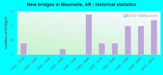
- New bridges - historical statistics
- 21910-1919
- 11940-1949
- 71960-1969
- 21970-1979
- 21980-1989
- 51990-1999
- 52000-2009
- 62010-2019

- Reconstructed bridges - Historical Statistics
- 11950-1959
- 01960-1969
- 01970-1979
- 01980-1989
- 61990-1999


- Bridge Condition - Deck
- 16.7%Excellent
- 5.6%Very good
- 55.6%Good
- 22.2%Satisfactory

- Bridge Condition - Superstructure
- 22.2%Excellent
- 11.1%Very good
- 22.2%Good
- 44.4%Satisfactory

- Bridge Condition - Substructure
- 16.7%Excellent
- 5.6%Very good
- 55.6%Good
- 22.2%Satisfactory

- Bridge Condition - Channel
- 4.2%Excellent
- 25.0%Very good
- 25.0%Good
- 37.5%Satisfactory
- 8.3%Fair

- Bridge Condition - Culverts
- 16.7%Very good
- 58.3%Good
- 25.0%Satisfactory
Find on map >> Show street view
Structure Number: 2222, Location: .46 M W of Perry Co. Line (Lat: 34.967111, Lng: -93.189139), Route carried "on" structure: State highway 60, Year Built: 1942, Status: Open, Structure Length: 1.52m (4.99ft), Average Daily Traffic: 862 (year 2018), Truck Traffic: 1%, Average Future Daily Traffic: 649 (year 2028), Design Load: H 15, Features Intersected: Creek
Minimum Vertical Clearance: 30+ m (98+ ft), Kilometerpoint: 0.740, Lanes on structure: 2, Owner: State Highway Agency, Approaching Roadway Width: 8.5m (27.9ft), Material/Design: Concrete, Design/Construction: Culvert, Number Of Spans In Main Unit: 1, Length of Maximum Span: 11.0m (36.1ft)
Condition: Channel: Good, Culverts: Good, Operating Rating: 28.1 metric tons, Method Used To Determine Operating Rating: Load Factor (LF), Inventory Rating: 17.2 metric tons, Method Used To Determine Inventory Rating: Load Factor (LF), Structural Evaluation: Meets minimum limits, Waterway Adequacy: Equal to present desirable criteria, Approach Roadway Alignment: Equal to present desirable criteria, Designated Inspection Frequency: Every 24 months, Critical Feature Inspection Frequency: Every 24 months, Inspection Date: August 2020
Find on map >> Show street view
Structure Number: 7318, Location: 0.5 M W Crystal Hill (Lat: 34.827808, Lng: -92.345322), Route carried "on" structure: County highway 737, Year Built: 2016, Status: Open, Structure Length: 8.53m (27.99ft), Average Daily Traffic: 78,000 (year 2018), Truck Traffic: 1%, Average Future Daily Traffic: 75 (year 2036), Design Load: HL 93, Features Intersected: I-40 147.07
Minimum Vertical Clearance: 5.27m (17.29ft), Kilometerpoint: 0.595, Lanes on structure: 2, Lanes under structure: 8, Owner: State Highway Agency, Approaching Roadway Width: 7.3m (24.0ft), Material/Design: Steel continuous, Design/Construction: Stringer/Multi-beam, Number Of Spans In Main Unit: 2, Length of Maximum Span: 45.7m (149.9ft), Curb-To-Curb Width: 7.3m (24.0ft), Out-to-Out Width: 8.3m (27.2ft)
Condition: Deck: Excellent, Superstructure: Excellent, Substructure: Excellent, Operating Rating: 54.4 metric tons, Method Used To Determine Operating Rating: Load and Resistance Factor (LRFR), Inventory Rating: 32.7 metric tons, Method Used To Determine Inventory Rating: Load and Resistance Factor (LRFR), Structural Evaluation: Superior to present desirable criteria, Deck Geometry: High priority of replacement, Underclear: Superior to present desirable criteria, Approach Roadway Alignment: Better than present minimum criteria, Designated Inspection Frequency: Every 24 months, Critical Feature Inspection Frequency: Every 24 months, Inspection Date: June 2020, Deck Structure Type: Concrete Cast-file-Place, Wearing Surface/Protective System: Wearing Surface: Monolithic Concrete, Deck Protection: Epoxy Coated Reinforcing
Find on map >> Show street view
Structure Number: 7418, Location: 1.9miles NE of Hwy 100 (Lat: 34.841172, Lng: -92.351353), Route carried "on" structure: County highway 23842, Year Built: 2019, Status: Open, Structure Length: 9.88m (32.41ft), Average Daily Traffic: 80,000 (year 2019), Average Future Daily Traffic: 98,000 (year 2039), Design Load: HL 93, Features Intersected: I-40 145.95, Facility Carried by Structure: White Oak Crossing
Minimum Vertical Clearance: 30.44m (99.87ft), Kilometerpoint: 4.892, Lanes on structure: 4, Lanes under structure: 6, Owner: State Highway Agency, Approaching Roadway Width: 22.9m (75.1ft), Material/Design: Steel continuous, Design/Construction: Stringer/Multi-beam, Number Of Spans In Main Unit: 2, Length of Maximum Span: 49.4m (162.1ft), Curb-To-Curb Width: 22.9m (75.1ft), Out-to-Out Width: 23.8m (78.1ft)
Condition: Deck: Excellent, Superstructure: Excellent, Substructure: Excellent, Operating Rating: 54.4 metric tons, Method Used To Determine Operating Rating: Load and Resistance Factor (LRFR), Inventory Rating: 32.7 metric tons, Method Used To Determine Inventory Rating: Load and Resistance Factor (LRFR), Structural Evaluation: Superior to present desirable criteria, Deck Geometry: Superior to present desirable criteria, Underclear: Superior to present desirable criteria, Approach Roadway Alignment: Equal to present desirable criteria, Designated Inspection Frequency: Every 24 months, Critical Feature Inspection Frequency: Every 24 months, Inspection Date: January 2022, Deck Structure Type: Concrete Cast-file-Place, Wearing Surface/Protective System: Wearing Surface: Monolithic Concrete, Deck Protection: Epoxy Coated Reinforcing
Find on map >> Show street view
Structure Number: 16493, Location: 2.13 MI N JCT SH 365 (Lat: 34.892444, Lng: -92.326447), Route carried "on" structure: County highway 52, Year Built: 1961, Status: Open, Structure Length: 2.19m (7.19ft), Average Daily Traffic: 740 (year 2018), Truck Traffic: 1%, Average Future Daily Traffic: 718 (year 2007), Design Load: H 15, Features Intersected: White Oak Bayou
Minimum Vertical Clearance: 30+ m (98+ ft), Kilometerpoint: 3.426, Lanes on structure: 2, Owner: County Highway Agency, Approaching Roadway Width: 6.1m (20.0ft), Material/Design: Concrete, Design/Construction: Slab, Number Of Spans In Main Unit: 4, Length of Maximum Span: 5.5m (18.0ft), Curb or Sidewalk Widths: Left: 0.2m (0.7ft), Right: 0.2m (0.7ft), Curb-To-Curb Width: 7.3m (24.0ft), Out-to-Out Width: 7.7m (25.3ft)
Condition: Deck: Good, Superstructure: Good, Substructure: Good, Channel: Satisfactory, Operating Rating: 34.5 metric tons, Method Used To Determine Operating Rating: Load Factor (LF), Inventory Rating: 20.9 metric tons, Method Used To Determine Inventory Rating: Load Factor (LF), Structural Evaluation: Somewhat better than minimum adequacy, Deck Geometry: Meets minimum limits, Waterway Adequacy: Equal to present minimum criteria, Approach Roadway Alignment: Better than present minimum criteria, Designated Inspection Frequency: Every 24 months, Critical Feature Inspection Frequency: Every 24 months, Inspection Date: July 2021, Deck Structure Type: Concrete Cast-file-Place, Wearing Surface/Protective System: Wearing Surface: Monolithic Concrete
Find on map >> Show street view
Structure Number: 16496, Location: .2 MI E OF 365 (Lat: 34.883222, Lng: -92.407914), Route carried "on" structure: County highway 58, Year Built: 1974, Status: Open, Structure Length: 0.70m (2.30ft), Average Daily Traffic: 307 (year 2018), Truck Traffic: 1%, Average Future Daily Traffic: 264 (year 2007), Design Load: H 20, Features Intersected: DITCH
Minimum Vertical Clearance: 30+ m (98+ ft), Kilometerpoint: 0.306, Lanes on structure: 2, Owner: County Highway Agency, Approaching Roadway Width: 7.0m (23.0ft), Material/Design: Concrete, Design/Construction: Culvert, Number Of Spans In Main Unit: 2, Length of Maximum Span: 3.4m (11.2ft), Curb-To-Curb Width: 7.0m (23.0ft), Out-to-Out Width: 11.6m (38.1ft)
Condition: Channel: Satisfactory, Culverts: Good, Operating Rating: 41.7 metric tons, Method Used To Determine Operating Rating: Load Factor (LF), Inventory Rating: 25.4 metric tons, Method Used To Determine Inventory Rating: Load Factor (LF), Structural Evaluation: Equal to present minimum criteria, Deck Geometry: Meets minimum limits, Waterway Adequacy: Equal to present desirable criteria, Approach Roadway Alignment: Equal to present desirable criteria, Designated Inspection Frequency: Every 24 months, Critical Feature Inspection Frequency: Every 24 months, Inspection Date: July 2021
Find on map >> Show street view
Structure Number: 18368, Location: 4.27 MI W I-430(I-3) (Lat: 34.847481, Lng: -92.405369), Route carried "on" structure: State highway 100, Year Built: 1976, Status: Open, Structure Length: 0.94m (3.08ft), Average Daily Traffic: 26,372 (year 2018), Truck Traffic: 1%, Average Future Daily Traffic: 29,812 (year 2028), Features Intersected: BRANCH
Minimum Vertical Clearance: 30+ m (98+ ft), Kilometerpoint: 4.297, Lanes on structure: 4, Base Highway Network: Yes, Owner: State Highway Agency, Approaching Roadway Width: 21.6m (70.9ft), Material/Design: Concrete, Design/Construction: Culvert, Number Of Spans In Main Unit: 4, Length of Maximum Span: 2.1m (6.9ft), Curb or Sidewalk Widths: Left: 0.2m (0.7ft), Right: 0.2m (0.7ft)
Condition: Channel: Satisfactory, Culverts: Good, Operating Rating: 27.2 metric tons, Method Used To Determine Operating Rating: Load Factor (LF), Inventory Rating: 16.3 metric tons, Method Used To Determine Inventory Rating: Load Factor (LF), Structural Evaluation: Meets minimum limits, Waterway Adequacy: Equal to present desirable criteria, Approach Roadway Alignment: Equal to present desirable criteria, Designated Inspection Frequency: Every 24 months, Critical Feature Inspection Frequency: Every 24 months, Inspection Date: Febuary 2022
Find on map >> Show street view
Structure Number: 21276, Location: 0.7 Mi E of SH 365 (Lat: 34.866306, Lng: -92.332275), Route carried "on" structure: County highway 1259, Year Built: 1989, Status: Open, Structure Length: 0.94m (3.08ft), Average Daily Traffic: 612 (year 2018), Truck Traffic: 1%, Average Future Daily Traffic: 97 (year 2004), Features Intersected: WINIFREE CREEK, Facility Carried by Structure: Timber Creek Rd
Minimum Vertical Clearance: 30+ m (98+ ft), Kilometerpoint: 0.805, Lanes on structure: 2, Owner: County Highway Agency, Approaching Roadway Width: 9.1m (29.9ft), Material/Design: Concrete, Design/Construction: Channel Beam, Number Of Spans In Main Unit: 1, Length of Maximum Span: 9.4m (30.8ft), Curb or Sidewalk Widths: Left: 0.3m (1.0ft), Right: 0.3m (1.0ft), Curb-To-Curb Width: 9.6m (31.5ft), Out-to-Out Width: 10.2m (33.5ft)
Condition: Deck: Satisfactory, Superstructure: Satisfactory, Substructure: Satisfactory, Channel: Fair, Operating Rating: 54.4 metric tons, Method Used To Determine Operating Rating: Load Factor (LF), Inventory Rating: 32.7 metric tons, Method Used To Determine Inventory Rating: Load Factor (LF), Structural Evaluation: Equal to present minimum criteria, Deck Geometry: Equal to present minimum criteria, Waterway Adequacy: Equal to present desirable criteria, Approach Roadway Alignment: Equal to present desirable criteria, Designated Inspection Frequency: Every 24 months, Critical Feature Inspection Frequency: Every 24 months, Inspection Date: July 2021, Deck Structure Type: Concrete Cast-file-Place, Wearing Surface/Protective System: Wearing Surface: Monolithic Concrete
Find on map >> Show street view
Structure Number: 21367, Location: 0.5 Mi N of Lunn Rd (Lat: 34.885961, Lng: -92.336831), Route carried "on" structure: County highway 790, Year Built: 1993, Status: Open, Structure Length: 0.67m (2.20ft), Average Daily Traffic: 238 (year 2018), Truck Traffic: 1%, Average Future Daily Traffic: 60 (year 2007), Features Intersected: WHITE OAK CREEK
Minimum Vertical Clearance: 30+ m (98+ ft), Kilometerpoint: 0.966, Lanes on structure: 2, Owner: County Highway Agency, Approaching Roadway Width: 5.5m (18.0ft), Material/Design: Steel, Design/Construction: Culvert, Number Of Spans In Main Unit: 4, Length of Maximum Span: 1.5m (4.9ft)
Condition: Channel: Satisfactory, Culverts: Satisfactory, Operating Rating: 54.4 metric tons, Method Used To Determine Operating Rating: Load Factor (LF), Inventory Rating: 32.7 metric tons, Method Used To Determine Inventory Rating: Load Factor (LF), Structural Evaluation: Equal to present minimum criteria, Waterway Adequacy: Somewhat better than minimum adequacy, Approach Roadway Alignment: Equal to present desirable criteria, Designated Inspection Frequency: Every 24 months, Critical Feature Inspection Frequency: Every 24 months, Inspection Date: October 2021
Find on map >> Show street view
Structure Number: 2166, Location: 1.3 Mi e of SH 365 (Lat: 34.871339, Lng: -92.321300), Route carried "on" structure: County highway 788, Year Built: 1996, Status: Open, Structure Length: 1.04m (3.41ft), Average Daily Traffic: 1,083 (year 2018), Truck Traffic: 1%, Average Future Daily Traffic: 30 (year 2007), Features Intersected: WINIFREE CREEK
Minimum Vertical Clearance: 30+ m (98+ ft), Kilometerpoint: 1.688, Lanes on structure: 2, Owner: County Highway Agency, Approaching Roadway Width: 6.1m (20.0ft), Skew: 1 degrees, Material/Design: Steel, Design/Construction: Culvert, Number Of Spans In Main Unit: 4, Length of Maximum Span: 2.1m (6.9ft)
Condition: Channel: Satisfactory, Culverts: Good, Operating Rating: 54.4 metric tons, Method Used To Determine Operating Rating: Load Factor (LF), Inventory Rating: 32.7 metric tons, Method Used To Determine Inventory Rating: Load Factor (LF), Structural Evaluation: Better than present minimum criteria, Waterway Adequacy: Equal to present minimum criteria, Approach Roadway Alignment: Equal to present minimum criteria, Designated Inspection Frequency: Every 24 months, Critical Feature Inspection Frequency: Every 24 months, Inspection Date: December 2021
Find on map >> Show street view
Structure Number: 21716, Location: 1.41 MI S JCT SH 365 (Lat: 34.879517, Lng: -92.440436), Route carried "on" structure: County highway 701, Year Built: 1996, Status: Open, Structure Length: 3.78m (12.40ft), Average Daily Traffic: 45 (year 2018), Truck Traffic: 1%, Average Future Daily Traffic: 60 (year 2007), Design Load: HS 20, Features Intersected: WHITE OAK CREEK
Minimum Vertical Clearance: 30+ m (98+ ft), Kilometerpoint: 2.269, Lanes on structure: 2, Owner: County Highway Agency, Approaching Roadway Width: 9.1m (29.9ft), Skew: 3 degrees, Material/Design: Concrete, Design/Construction: Channel Beam, Number Of Spans In Main Unit: 4, Length of Maximum Span: 8.8m (28.9ft), Curb-To-Curb Width: 8.5m (27.9ft), Out-to-Out Width: 8.5m (27.9ft)
Condition: Deck: Good, Superstructure: Satisfactory, Substructure: Good, Channel: Good, Operating Rating: 54.4 metric tons, Method Used To Determine Operating Rating: Load Factor (LF), Inventory Rating: 32.7 metric tons, Method Used To Determine Inventory Rating: Load Factor (LF), Structural Evaluation: Equal to present minimum criteria, Deck Geometry: Better than present minimum criteria, Waterway Adequacy: Equal to present desirable criteria, Approach Roadway Alignment: Equal to present minimum criteria, Designated Inspection Frequency: Every 24 months, Critical Feature Inspection Frequency: Every 24 months, Inspection Date: June 2020, Deck Structure Type: Concrete Precast Panels, Wearing Surface/Protective System: Wearing Surface: Monolithic Concrete
Find on map >> Show street view
Structure Number: 22205, Location: 0.25 MI W AUDUBON DR (Lat: 34.852444, Lng: -92.410881), Route carried "on" structure: City street 43930, Year Built: 1981, Status: Posted for load, Structure Length: 1.07m (3.51ft), Average Daily Traffic: 146 (year 2018), Truck Traffic: 1%, Average Future Daily Traffic: 130 (year 2020), Design Load: H 20, Features Intersected: LAKE WILLASTEIN, Facility Carried by Structure: Lake Willastein Dr
Minimum Vertical Clearance: 30+ m (98+ ft), Kilometerpoint: 0.402, Lanes on structure: 2, Owner: City or Municipal Highway Agency, Approaching Roadway Width: 6.1m (20.0ft), Material/Design: Wood or Timber, Design/Construction: Stringer/Multi-beam, Number Of Spans In Main Unit: 1, Length of Maximum Span: 10.4m (34.1ft), Curb-To-Curb Width: 6.1m (20.0ft), Out-to-Out Width: 6.4m (21.0ft)
Condition: Deck: Good, Superstructure: Good, Substructure: Satisfactory, Channel: Very good, Operating Rating: 28.1 metric tons, Method Used To Determine Operating Rating: Allowable Stress (AS), Inventory Rating: 20.0 metric tons, Method Used To Determine Inventory Rating: Allowable Stress (AS), Structural Evaluation: Somewhat better than minimum adequacy, Deck Geometry: Meets minimum limits, Waterway Adequacy: Equal to present desirable criteria, Approach Roadway Alignment: Equal to present minimum criteria, Bridge Posting: Required (Relationship of Operating Rating to Maximum Legal Load: 30.0 - 39.9% below), Designated Inspection Frequency: Every 24 months, Critical Feature Inspection Frequency: Every 24 months, Inspection Date: July 2021, Deck Structure Type: Wood or Timber, Wearing Surface/Protective System: Wearing Surface: Bituminous
Find on map >> Show street view
Structure Number: 22215, Location: .2 MI S OF MONTELIER (Lat: 34.847242, Lng: -92.404425), Route carried "on" structure: City street 15200, Year Built: 1998, Status: Open, Structure Length: 0.85m (2.79ft), Average Daily Traffic: 2,052 (year 2018), Truck Traffic: 1%, Average Future Daily Traffic: 130 (year 2020), Features Intersected: BRANCH, Facility Carried by Structure: DEAUVILLE DR
Minimum Vertical Clearance: 30+ m (98+ ft), Kilometerpoint: 0.322, Lanes on structure: 2, Owner: City or Municipal Highway Agency, Approaching Roadway Width: 10.7m (35.1ft), Material/Design: Steel, Design/Construction: Culvert, Number Of Spans In Main Unit: 7, Length of Maximum Span: 0.9m (3.0ft), Curb or Sidewalk Widths: Left: 0.3m (1.0ft), Right: 0.3m (1.0ft), Curb-To-Curb Width: 10.7m (35.1ft), Out-to-Out Width: 12.8m (42.0ft)
Condition: Channel: Good, Culverts: Very good, Operating Rating: 54.4 metric tons, Method Used To Determine Operating Rating: Load Factor (LF), Inventory Rating: 32.7 metric tons, Method Used To Determine Inventory Rating: Load Factor (LF), Structural Evaluation: Equal to present desirable criteria, Deck Geometry: Somewhat better than minimum adequacy, Waterway Adequacy: Equal to present minimum criteria, Approach Roadway Alignment: Equal to present desirable criteria, Designated Inspection Frequency: Every 24 months, Critical Feature Inspection Frequency: Every 24 months, Inspection Date: June 2020
Find on map >> Show street view
Structure Number: 22216, Location: .05 MI S /CNTRY CLUB BLVD (Lat: 34.839750, Lng: -92.397886), Route carried "on" structure: City street 20854, Year Built: 2000, Status: Open, Structure Length: 1.13m (3.71ft), Average Daily Traffic: 905 (year 2018), Truck Traffic: 1%, Average Future Daily Traffic: 130 (year 2020), Features Intersected: BRANCH, Facility Carried by Structure: FOUNTAIN BLEAU DRI
Minimum Vertical Clearance: 30+ m (98+ ft), Kilometerpoint: 0.080, Lanes on structure: 2, Owner: City or Municipal Highway Agency, Approaching Roadway Width: 10.7m (35.1ft), Material/Design: Steel, Design/Construction: Culvert, Number Of Spans In Main Unit: 4, Length of Maximum Span: 2.4m (7.9ft), Curb or Sidewalk Widths: Left: 1.5m (4.9ft), Right: 0.3m (1.0ft), Curb-To-Curb Width: 10.7m (35.1ft), Out-to-Out Width: 21.0m (68.9ft)
Condition: Channel: Satisfactory, Culverts: Good, Operating Rating: 54.4 metric tons, Method Used To Determine Operating Rating: Load Factor (LF), Inventory Rating: 32.7 metric tons, Method Used To Determine Inventory Rating: Load Factor (LF), Structural Evaluation: Better than present minimum criteria, Deck Geometry: Equal to present minimum criteria, Waterway Adequacy: Equal to present minimum criteria, Approach Roadway Alignment: Equal to present desirable criteria, Designated Inspection Frequency: Every 24 months, Critical Feature Inspection Frequency: Every 24 months, Inspection Date: June 2020
Find on map >> Show street view
Structure Number: 2222, Location: .3 MI. W OF SH 100 (Lat: 34.878028, Lng: -92.401014), Route carried "on" structure: City street 49725, Year Built: 1990, Status: Open, Structure Length: 0.65m (2.13ft), Average Daily Traffic: 3,271 (year 2018), Truck Traffic: 1%, Average Future Daily Traffic: 130 (year 2020), Features Intersected: BRANCH, Facility Carried by Structure: ROLLING OAKS DRIVE
Minimum Vertical Clearance: 30+ m (98+ ft), Kilometerpoint: 0.483, Lanes on structure: 2, Owner: City or Municipal Highway Agency, Approaching Roadway Width: 10.7m (35.1ft), Material/Design: Steel, Design/Construction: Culvert, Number Of Spans In Main Unit: 4, Length of Maximum Span: 1.4m (4.6ft), Curb or Sidewalk Widths: Left: 2.1m (6.9ft), Right: 2.1m (6.9ft), Curb-To-Curb Width: 10.5m (34.4ft), Out-to-Out Width: 15.7m (51.5ft)
Condition: Channel: Very good, Culverts: Satisfactory, Operating Rating: 54.4 metric tons, Method Used To Determine Operating Rating: Load Factor (LF), Inventory Rating: 32.7 metric tons, Method Used To Determine Inventory Rating: Load Factor (LF), Structural Evaluation: Equal to present minimum criteria, Deck Geometry: Somewhat better than minimum adequacy, Waterway Adequacy: Equal to present desirable criteria, Approach Roadway Alignment: Equal to present desirable criteria, Designated Inspection Frequency: Every 24 months, Critical Feature Inspection Frequency: Every 24 months, Inspection Date: June 2020
Find on map >> Show street view
Structure Number: 22496, Location: 0.6 Mi E of SH 100 (Lat: 34.843083, Lng: -92.394308), Route carried "on" structure: City street 13220, Year Built: 2002, Status: Open, Structure Length: 1.46m (4.79ft), Average Daily Traffic: 3,976 (year 2018), Truck Traffic: 1%, Average Future Daily Traffic: 130 (year 2022), Features Intersected: Creek, Facility Carried by Structure: Country Club Pkwy
Minimum Vertical Clearance: 30+ m (98+ ft), Kilometerpoint: 0.966, Lanes on structure: 2, Owner: City or Municipal Highway Agency, Approaching Roadway Width: 13.7m (44.9ft), Skew: 4 degrees, Material/Design: Concrete, Design/Construction: Culvert, Number Of Spans In Main Unit: 4, Length of Maximum Span: 1.2m (3.9ft), Curb-To-Curb Width: 22.6m (74.1ft), Out-to-Out Width: 22.6m (74.1ft)
Condition: Channel: Good, Culverts: Satisfactory, Operating Rating: 49.9 metric tons, Method Used To Determine Operating Rating: Load Factor (LF), Inventory Rating: 29.9 metric tons, Method Used To Determine Inventory Rating: Load Factor (LF), Structural Evaluation: Equal to present minimum criteria, Deck Geometry: Superior to present desirable criteria, Waterway Adequacy: Equal to present desirable criteria, Approach Roadway Alignment: Equal to present desirable criteria, Designated Inspection Frequency: Every 24 months, Critical Feature Inspection Frequency: Every 24 months, Inspection Date: June 2020, Deck Structure Type: Concrete Cast-file-Place
Find on map >> Show street view
Structure Number: 22937, Location: 0.3 Mi W of SH 365 (Lat: 34.864075, Lng: -92.351028), Route carried "on" structure: County highway 725, Year Built: 2007, Status: Open, Structure Length: 0.67m (2.20ft), Average Daily Traffic: 260 (year 2018), Truck Traffic: 1%, Average Future Daily Traffic: 97 (year 2004), Features Intersected: Winifree Creek
Minimum Vertical Clearance: 30.17m (98.98ft), Kilometerpoint: 0.354, Lanes on structure: 2, Owner: County Highway Agency, Approaching Roadway Width: 8.5m (27.9ft), Skew: 1 degrees, Material/Design: Concrete, Design/Construction: Culvert, Number Of Spans In Main Unit: 2, Length of Maximum Span: 2.7m (8.9ft), Curb-To-Curb Width: 8.5m (27.9ft), Out-to-Out Width: 12.8m (42.0ft)
Condition: Channel: Satisfactory, Culverts: Good, Operating Rating: 32.7 metric tons, Method Used To Determine Operating Rating: Load Factor (LF), Inventory Rating: 19.1 metric tons, Method Used To Determine Inventory Rating: Load Factor (LF), Structural Evaluation: Somewhat better than minimum adequacy, Deck Geometry: Equal to present minimum criteria, Waterway Adequacy: Equal to present desirable criteria, Approach Roadway Alignment: Equal to present desirable criteria, Designated Inspection Frequency: Every 24 months, Critical Feature Inspection Frequency: Every 24 months, Inspection Date: July 2021
Find on map >> Show street view
Structure Number: 23515, Location: 0.29 N of Odom Blvd. (Lat: 34.879778, Lng: -92.407806), Route carried "on" structure: City street 63450, Year Built: 2012, Status: Open, Structure Length: 0.77m (2.53ft), Average Daily Traffic: 1,069 (year 2018), Truck Traffic: 1%, Average Future Daily Traffic: 28 (year 2032), Features Intersected: Ditch, Facility Carried by Structure: Woodland Drive
Minimum Vertical Clearance: 30+ m (98+ ft), Kilometerpoint: 1.609, Lanes on structure: 2, Owner: City or Municipal Highway Agency, Approaching Roadway Width: 6.6m (21.7ft), Material/Design: Concrete, Design/Construction: Culvert, Number Of Spans In Main Unit: 3, Length of Maximum Span: 2.4m (7.9ft), Curb or Sidewalk Widths: Left: 0.0m, Right: 1.5m (4.9ft)
Condition: Channel: Good, Culverts: Very good, Operating Rating: 47.2 metric tons, Method Used To Determine Operating Rating: Load Factor (LF), Inventory Rating: 28.1 metric tons, Method Used To Determine Inventory Rating: Load Factor (LF), Structural Evaluation: Better than present minimum criteria, Waterway Adequacy: Better than present minimum criteria, Approach Roadway Alignment: Equal to present desirable criteria, Designated Inspection Frequency: Every 24 months, Critical Feature Inspection Frequency: Every 24 months, Inspection Date: August 2020
Find on map >> Show street view
Structure Number: 23608, Location: 0.30 W of Odom Blvd. (Lat: 34.861247, Lng: -92.426303), Route carried "on" structure: City street 36665, Year Built: 2012, Status: Open, Structure Length: 1.00m (3.28ft), Average Daily Traffic: 1,478 (year 2018), Truck Traffic: 1%, Average Future Daily Traffic: 225 (year 2032), Features Intersected: Ditch, Facility Carried by Structure: Maumelle Valley Dr
Minimum Vertical Clearance: 30+ m (98+ ft), Kilometerpoint: 0.483, Lanes on structure: 2, Owner: City or Municipal Highway Agency, Approaching Roadway Width: 9.2m (30.2ft), Skew: 1 degrees, Material/Design: Concrete, Design/Construction: Culvert, Number Of Spans In Main Unit: 3, Length of Maximum Span: 3.0m (9.8ft), Curb or Sidewalk Widths: Left: 0.0m, Right: 1.2m (3.9ft)
Condition: Channel: Satisfactory, Culverts: Good, Operating Rating: 41.7 metric tons, Method Used To Determine Operating Rating: Load Factor (LF), Inventory Rating: 25.4 metric tons, Method Used To Determine Inventory Rating: Load Factor (LF), Structural Evaluation: Equal to present minimum criteria, Waterway Adequacy: Equal to present minimum criteria, Approach Roadway Alignment: Equal to present desirable criteria, Designated Inspection Frequency: Every 24 months, Critical Feature Inspection Frequency: Every 24 months, Inspection Date: August 2020
Find on map >> Show street view
Structure Number: 23842, Location: 2.5 miles NE of Hwy 100 (Lat: 34.840778, Lng: -92.359119), Route carried "on" structure: Alternate City street 13212, Year Built: 2017, Status: Open, Structure Length: 12.58m (41.27ft), Average Daily Traffic: 100 (year 2017), Truck Traffic: 1%, Average Future Daily Traffic: 500 (year 2037), Design Load: HL 93, Features Intersected: White Oak Bayou, Facility Carried by Structure: Counts Massie Road
Minimum Vertical Clearance: 30+ m (98+ ft), Kilometerpoint: 4.023, Lanes on structure: 2, Owner: City or Municipal Highway Agency, Approaching Roadway Width: 14.3m (46.9ft), Skew: 3 degrees, Material/Design: Steel continuous, Design/Construction: Stringer/Multi-beam, Number Of Spans In Main Unit: 4, Length of Maximum Span: 33.5m (109.9ft), Curb-To-Curb Width: 9.1m (29.9ft), Out-to-Out Width: 14.4m (47.2ft)
Condition: Deck: Very good, Superstructure: Excellent, Substructure: Very good, Channel: Excellent, Operating Rating: 39.0 metric tons, Method Used To Determine Operating Rating: Load and Resistance Factor (LRFR), Inventory Rating: 30.8 metric tons, Method Used To Determine Inventory Rating: Load and Resistance Factor (LRFR), Structural Evaluation: Better than present minimum criteria, Deck Geometry: Better than present minimum criteria, Waterway Adequacy: Superior to present desirable criteria, Approach Roadway Alignment: Equal to present desirable criteria, Designated Inspection Frequency: Every 24 months, Critical Feature Inspection Frequency: Every 24 months, Inspection Date: March 2020, Deck Structure Type: Concrete Cast-file-Place, Wearing Surface/Protective System: Wearing Surface: Monolithic Concrete, Deck Protection: Epoxy Coated Reinforcing
Find on map >> Show street view
Structure Number: 23906, Location: 1MI SO of SH 365 (Lat: 34.874250, Lng: -92.362200), Route carried "on" structure: County highway 54, Year Built: 2017, Status: Open, Structure Length: 0.99m (3.25ft), Average Daily Traffic: 850 (year 2018), Truck Traffic: 5%, Average Future Daily Traffic: 775 (year 2037), Design Load: HS 20, Features Intersected: White Oak Bayou, Facility Carried by Structure: Marche Road
Minimum Vertical Clearance: 30+ m (98+ ft), Kilometerpoint: 3.943, Lanes on structure: 2, Owner: County Highway Agency, Approaching Roadway Width: 6.7m (22.0ft), Material/Design: Concrete, Design/Construction: Channel Beam, Number Of Spans In Main Unit: 1, Length of Maximum Span: 8.8m (28.9ft), Curb or Sidewalk Widths: Left: 0.2m (0.7ft), Right: 0.2m (0.7ft), Curb-To-Curb Width: 8.4m (27.6ft), Out-to-Out Width: 8.8m (28.9ft)
Condition: Deck: Excellent, Superstructure: Excellent, Substructure: Excellent, Channel: Satisfactory, Operating Rating: 54.4 metric tons, Method Used To Determine Operating Rating: Load Factor (LF), Inventory Rating: 32.7 metric tons, Method Used To Determine Inventory Rating: Load Factor (LF), Structural Evaluation: Superior to present desirable criteria, Deck Geometry: Somewhat better than minimum adequacy, Waterway Adequacy: Equal to present minimum criteria, Approach Roadway Alignment: Better than present minimum criteria, Designated Inspection Frequency: Every 24 months, Critical Feature Inspection Frequency: Every 24 months, Inspection Date: July 2021, Deck Structure Type: Concrete Precast Panels, Wearing Surface/Protective System: Wearing Surface: Monolithic Concrete
Find on map >> Show street view
Structure Number: A323, Location: 1.5 MI SE OF MORGAN/I-3 (Lat: 34.870528, Lng: -92.365778), Route carried "on" structure: Interstate 40, Year Built: 1963, Year Reconstructed: 1998, Status: Open, Structure Length: 4.57m (14.99ft), Average Daily Traffic: 39,000 (year 2018), Truck Traffic: 20%, Average Future Daily Traffic: 44,500 (year 2034), Design Load: HS 20, Features Intersected: WHITE OAK BAYOU
Minimum Vertical Clearance: 30+ m (98+ ft), Kilometerpoint: 231.263, Lanes on structure: 3, Base Highway Network: Yes (Inventory Route: 403, Subroute: 1), Owner: State Highway Agency, Approaching Roadway Width: 17.1m (56.1ft), Material/Design: Concrete, Design/Construction: Tee Beam, Number Of Spans In Main Unit: 5, Length of Maximum Span: 9.1m (29.9ft), Curb-To-Curb Width: 17.1m (56.1ft), Out-to-Out Width: 17.9m (58.7ft)
Condition: Deck: Satisfactory, Superstructure: Satisfactory, Substructure: Good, Channel: Very good, Operating Rating: 54.4 metric tons, Method Used To Determine Operating Rating: Load Factor (LF), Inventory Rating: 32.7 metric tons, Method Used To Determine Inventory Rating: Load Factor (LF), Structural Evaluation: Equal to present minimum criteria, Deck Geometry: Equal to present minimum criteria, Waterway Adequacy: Equal to present desirable criteria, Approach Roadway Alignment: Equal to present desirable criteria, Designated Inspection Frequency: Every 24 months, Critical Feature Inspection Frequency: Every 24 months, Inspection Date: June 2020, Deck Structure Type: Concrete Cast-file-Place, Wearing Surface/Protective System: Wearing Surface: Monolithic Concrete, Deck Protection: Epoxy Coated Reinforcing
Find on map >> Show street view
Structure Number: A3232, Location: 1 MI NW OAK GROVE (Lat: 34.856011, Lng: -92.350531), Route carried "on" structure: Interstate 40, Year Built: 1963, Year Reconstructed: 1998, Status: Open, Structure Length: 12.80m (41.99ft), Average Daily Traffic: 39,000 (year 2018), Truck Traffic: 17%, Average Future Daily Traffic: 44,070 (year 2028), Design Load: HS 20, Features Intersected: CR719& RR
Minimum Vertical Clearance: 4.87m (15.98ft), Kilometerpoint: 233.484, Lanes on structure: 3, Lanes under structure: 2, Base Highway Network: Yes, Owner: State Highway Agency, Approaching Roadway Width: 11.6m (38.1ft), Skew: 4 degrees, Material/Design: Steel continuous, Design/Construction: Stringer/Multi-beam, Number Of Spans In Main Unit: 6, Length of Maximum Span: 25.9m (85.0ft), Curb-To-Curb Width: 17.1m (56.1ft), Out-to-Out Width: 17.9m (58.7ft)
Condition: Deck: Good, Superstructure: Satisfactory, Substructure: Good, Operating Rating: 54.4 metric tons, Method Used To Determine Operating Rating: Load Factor (LF), Inventory Rating: 32.7 metric tons, Method Used To Determine Inventory Rating: Load Factor (LF), Structural Evaluation: Equal to present minimum criteria, Deck Geometry: Equal to present minimum criteria, Underclear: Somewhat better than minimum adequacy, Approach Roadway Alignment: Equal to present desirable criteria, Length Of Structure Improvement: 14.05m (46.10ft), Designated Inspection Frequency: Every 24 months, Critical Feature Inspection Frequency: Every 24 months, Inspection Date: June 2020, Roadway Improvement Cost: $247,000, Total Project Cost: $1,513,000, Deck Structure Type: Concrete Cast-file-Place, Wearing Surface/Protective System: Wearing Surface: Monolithic Concrete
Find on map >> Show street view
Structure Number: A3233, Location: 1.0 MI N JCT I-430 & I-40 (Lat: 34.835761, Lng: -92.347639), Route carried "on" structure: Interstate 40, Year Built: 1963, Year Reconstructed: 1998, Status: Open, Structure Length: 2.74m (8.99ft), Average Daily Traffic: 39,000 (year 2018), Truck Traffic: 20%, Average Future Daily Traffic: 44,500 (year 2034), Design Load: HS 20, Features Intersected: NEWTON CREEK
Minimum Vertical Clearance: 30+ m (98+ ft), Kilometerpoint: 235.705, Lanes on structure: 4, Base Highway Network: Yes (Inventory Route: 403, Subroute: 1), Owner: State Highway Agency, Approaching Roadway Width: 20.4m (66.9ft), Material/Design: Concrete, Design/Construction: Tee Beam, Number Of Spans In Main Unit: 3, Length of Maximum Span: 9.1m (29.9ft), Curb-To-Curb Width: 19.5m (64.0ft), Out-to-Out Width: 20.4m (66.9ft)
Condition: Deck: Good, Superstructure: Good, Substructure: Good, Channel: Very good, Operating Rating: 54.4 metric tons, Method Used To Determine Operating Rating: Load Factor (LF), Inventory Rating: 32.7 metric tons, Method Used To Determine Inventory Rating: Load Factor (LF), Structural Evaluation: Better than present minimum criteria, Deck Geometry: Somewhat better than minimum adequacy, Waterway Adequacy: Equal to present desirable criteria, Approach Roadway Alignment: Equal to present desirable criteria, Designated Inspection Frequency: Every 24 months, Critical Feature Inspection Frequency: Every 24 months, Inspection Date: November 2021, Deck Structure Type: Concrete Cast-file-Place, Wearing Surface/Protective System: Wearing Surface: Epoxy Overlay, Deck Protection: Epoxy Coated Reinforcing
Find on map >> Show street view
Structure Number: A7037, Location: 0.2 Mi S of SH 365 (Lat: 34.880589, Lng: -92.393128), Route carried "on" structure: State highway 100, Year Built: 2007, Status: Open, Structure Length: 6.62m (21.72ft), Average Daily Traffic: 5,750 (year 2018), Truck Traffic: 5%, Average Future Daily Traffic: 11,666 (year 2028), Design Load: HS 20, Features Intersected: UPRR
Minimum Vertical Clearance: 7.39m (24.25ft), Kilometerpoint: 0.418, Lanes on structure: 2, Base Highway Network: Yes (Inventory Route: 100, Subroute: 1), Owner: State Highway Agency, Approaching Roadway Width: 9.1m (29.9ft), Material/Design: Steel continuous, Design/Construction: Stringer/Multi-beam, Number Of Spans In Main Unit: 3, Length of Maximum Span: 27.1m (88.9ft), Curb or Sidewalk Widths: Left: 0.0m, Right: 3.2m (10.5ft), Curb-To-Curb Width: 9.1m (29.9ft), Out-to-Out Width: 13.3m (43.6ft)
Condition: Deck: Good, Superstructure: Very good, Substructure: Good, Operating Rating: 54.4 metric tons, Method Used To Determine Operating Rating: Load Factor (LF), Inventory Rating: 32.7 metric tons, Method Used To Determine Inventory Rating: Load Factor (LF), Structural Evaluation: Better than present minimum criteria, Deck Geometry: Meets minimum limits, Underclear: Superior to present desirable criteria, Approach Roadway Alignment: Equal to present desirable criteria, Designated Inspection Frequency: Every 24 months, Critical Feature Inspection Frequency: Every 24 months, Inspection Date: June 2020, Deck Structure Type: Concrete Cast-file-Place, Wearing Surface/Protective System: Wearing Surface: Monolithic Concrete, Deck Protection: Epoxy Coated Reinforcing
Find on map >> Show street view
Structure Number: B323, Location: 1.5 MI SE OF MORGAN (Lat: 34.870350, Lng: -92.365969), Route carried "on" structure: Interstate 40, Year Built: 1963, Year Reconstructed: 1998, Status: Open, Structure Length: 4.57m (14.99ft), Average Daily Traffic: 39,000 (year 2018), Truck Traffic: 14%, Average Future Daily Traffic: 44,500 (year 2034), Design Load: HS 20, Features Intersected: WHITE OAK BAYOU
Minimum Vertical Clearance: 30+ m (98+ ft), Kilometerpoint: 231.263, Lanes on structure: 3, Base Highway Network: Yes (Inventory Route: 403, Subroute: 1), Owner: State Highway Agency, Approaching Roadway Width: 12.2m (40.0ft), Material/Design: Concrete, Design/Construction: Tee Beam, Number Of Spans In Main Unit: 5, Length of Maximum Span: 9.1m (29.9ft), Curb-To-Curb Width: 17.1m (56.1ft), Out-to-Out Width: 17.9m (58.7ft)
Condition: Deck: Satisfactory, Superstructure: Satisfactory, Substructure: Good, Channel: Very good, Operating Rating: 54.4 metric tons, Method Used To Determine Operating Rating: Load Factor (LF), Inventory Rating: 32.7 metric tons, Method Used To Determine Inventory Rating: Load Factor (LF), Structural Evaluation: Equal to present minimum criteria, Deck Geometry: Equal to present minimum criteria, Waterway Adequacy: Equal to present desirable criteria, Approach Roadway Alignment: Equal to present desirable criteria, Designated Inspection Frequency: Every 24 months, Critical Feature Inspection Frequency: Every 24 months, Inspection Date: June 2020, Deck Structure Type: Concrete Cast-file-Place, Wearing Surface/Protective System: Wearing Surface: Monolithic Concrete, Deck Protection: Epoxy Coated Reinforcing
Find on map >> Show street view
Structure Number: B3232, Location: 1 MI NW OF OAK GROVE/I-2 (Lat: 34.856550, Lng: -92.351331), Route carried "on" structure: Interstate 40, Year Built: 1963, Year Reconstructed: 1998, Status: Open, Structure Length: 12.89m (42.29ft), Average Daily Traffic: 39,000 (year 2018), Truck Traffic: 14%, Average Future Daily Traffic: 44,070 (year 2028), Design Load: HS 20, Features Intersected: CR 719, RR
Minimum Vertical Clearance: 5.02m (16.47ft), Kilometerpoint: 233.484, Lanes on structure: 3, Lanes under structure: 2, Base Highway Network: Yes, Owner: State Highway Agency, Approaching Roadway Width: 17.1m (56.1ft), Skew: 4 degrees, Material/Design: Steel continuous, Design/Construction: Stringer/Multi-beam, Number Of Spans In Main Unit: 6, Length of Maximum Span: 25.9m (85.0ft), Curb-To-Curb Width: 17.1m (56.1ft), Out-to-Out Width: 17.9m (58.7ft)
Condition: Deck: Good, Superstructure: Satisfactory, Substructure: Good, Operating Rating: 54.4 metric tons, Method Used To Determine Operating Rating: Load Factor (LF), Inventory Rating: 32.7 metric tons, Method Used To Determine Inventory Rating: Load Factor (LF), Structural Evaluation: Equal to present minimum criteria, Deck Geometry: Equal to present minimum criteria, Underclear: Equal to present minimum criteria, Approach Roadway Alignment: Equal to present desirable criteria, Length Of Structure Improvement: 14.05m (46.10ft), Designated Inspection Frequency: Every 24 months, Critical Feature Inspection Frequency: Every 24 months, Inspection Date: June 2020, Roadway Improvement Cost: $247,000, Total Project Cost: $1,513,000, Deck Structure Type: Concrete Cast-file-Place, Wearing Surface/Protective System: Wearing Surface: Monolithic Concrete, Deck Protection: Epoxy Coated Reinforcing
Find on map >> Show street view
Structure Number: B3233, Location: 1 MI NW OF I-430/I-2 (Lat: 34.835550, Lng: -92.348139), Route carried "on" structure: Interstate 40, Year Built: 1963, Year Reconstructed: 1998, Status: Open, Structure Length: 2.74m (8.99ft), Average Daily Traffic: 39,000 (year 2018), Truck Traffic: 14%, Average Future Daily Traffic: 44,500 (year 2034), Design Load: HS 20, Features Intersected: NEWTON CREEK
Minimum Vertical Clearance: 30+ m (98+ ft), Kilometerpoint: 235.705, Lanes on structure: 4, Base Highway Network: Yes (Inventory Route: 403, Subroute: 1), Owner: State Highway Agency, Approaching Roadway Width: 19.5m (64.0ft), Material/Design: Concrete, Design/Construction: Tee Beam, Number Of Spans In Main Unit: 3, Length of Maximum Span: 9.1m (29.9ft), Curb-To-Curb Width: 19.5m (64.0ft), Out-to-Out Width: 20.4m (66.9ft)
Condition: Deck: Good, Superstructure: Good, Substructure: Good, Channel: Very good, Operating Rating: 54.4 metric tons, Method Used To Determine Operating Rating: Load Factor (LF), Inventory Rating: 32.7 metric tons, Method Used To Determine Inventory Rating: Load Factor (LF), Structural Evaluation: Better than present minimum criteria, Deck Geometry: Somewhat better than minimum adequacy, Waterway Adequacy: Equal to present desirable criteria, Approach Roadway Alignment: Equal to present desirable criteria, Designated Inspection Frequency: Every 24 months, Critical Feature Inspection Frequency: Every 24 months, Inspection Date: November 2021, Deck Structure Type: Concrete Cast-file-Place, Wearing Surface/Protective System: Wearing Surface: Epoxy Overlay, Deck Protection: Epoxy Coated Reinforcing
Find on map >> Show street view
Structure Number: B7037, Location: 0.2 Mi South of SH 365 (Lat: 34.880497, Lng: -92.392869), Route carried "on" structure: State highway 100, Year Built: 2006, Status: Open, Structure Length: 6.62m (21.72ft), Average Daily Traffic: 5,750 (year 2018), Truck Traffic: 5%, Average Future Daily Traffic: 11,666 (year 2028), Design Load: HS 20, Features Intersected: UPRR
Minimum Vertical Clearance: 30+ m (98+ ft), Kilometerpoint: 0.418, Lanes on structure: 2, Owner: State Highway Agency, Approaching Roadway Width: 10.4m (34.1ft), Material/Design: Steel continuous, Design/Construction: Stringer/Multi-beam, Number Of Spans In Main Unit: 3, Length of Maximum Span: 27.1m (88.9ft), Curb or Sidewalk Widths: Left: 2.0m (6.6ft), Right: 0.0m, Curb-To-Curb Width: 10.4m (34.1ft), Out-to-Out Width: 13.3m (43.6ft)
Condition: Deck: Good, Superstructure: Very good, Substructure: Good, Operating Rating: 54.4 metric tons, Method Used To Determine Operating Rating: Load Factor (LF), Inventory Rating: 32.7 metric tons, Method Used To Determine Inventory Rating: Load Factor (LF), Structural Evaluation: Better than present minimum criteria, Deck Geometry: Somewhat better than minimum adequacy, Underclear: Superior to present desirable criteria, Approach Roadway Alignment: Equal to present desirable criteria, Designated Inspection Frequency: Every 24 months, Critical Feature Inspection Frequency: Every 24 months, Inspection Date: June 2020, Deck Structure Type: Concrete Cast-file-Place, Wearing Surface/Protective System: Wearing Surface: Monolithic Concrete, Deck Protection: Epoxy Coated Reinforcing
Find on map >> Show street view
Structure Number: M2969, Location: 7.88MI SE OF FALK CO I-2 (Lat: 34.863250, Lng: -92.345078), Route carried "on" structure: State highway 365, Year Built: 1919, Year Reconstructed: 1955, Status: Posted for load, Structure Length: 1.28m (4.20ft), Average Daily Traffic: 5,085 (year 2018), Truck Traffic: 4%, Average Future Daily Traffic: 7,907 (year 2028), Features Intersected: WINEFREE CREEK
Minimum Vertical Clearance: 30+ m (98+ ft), Kilometerpoint: 12.678, Lanes on structure: 2, Base Highway Network: Yes, Owner: State Highway Agency, Approaching Roadway Width: 9.1m (29.9ft), Material/Design: Steel, Design/Construction: Stringer/Multi-beam, Number Of Spans In Main Unit: 1, Length of Maximum Span: 12.1m (39.7ft), Curb or Sidewalk Widths: Left: 0.4m (1.3ft), Right: 0.4m (1.3ft), Curb-To-Curb Width: 7.9m (25.9ft), Out-to-Out Width: 8.7m (28.5ft)
Condition: Deck: Good, Superstructure: Satisfactory, Substructure: Satisfactory, Channel: Fair, Operating Rating: 34.5 metric tons, Method Used To Determine Operating Rating: Load Factor (LF), Inventory Rating: 20.9 metric tons, Method Used To Determine Inventory Rating: Load Factor (LF), Structural Evaluation: Somewhat better than minimum adequacy, Deck Geometry: High priority of replacement, Waterway Adequacy: Equal to present desirable criteria, Approach Roadway Alignment: Equal to present desirable criteria, Bridge Posting: Required (Relationship of Operating Rating to Maximum Legal Load: 10.0 - 19.9% below), Length Of Structure Improvement: 2.04m (6.69ft), Designated Inspection Frequency: Every 24 months, Critical Feature Inspection Frequency: Every 24 months, Inspection Date: Febuary 2021, Roadway Improvement Cost: $265,000, Total Project Cost: $565,000, Deck Structure Type: Concrete Cast-file-Place, Wearing Surface/Protective System: Wearing Surface: Bituminous
Find on map >> Show street view
Structure Number: M297, Location: 5.62 MI N I-40/I-2 (Lat: 34.844061, Lng: -92.337631), Route carried "on" structure: State highway 365, Year Built: 1919, Status: Open, Structure Length: 2.01m (6.59ft), Average Daily Traffic: 5,188 (year 2018), Truck Traffic: 4%, Average Future Daily Traffic: 7,907 (year 2028), Features Intersected: NEWTON CREEK
Minimum Vertical Clearance: 30+ m (98+ ft), Kilometerpoint: 14.980, Lanes on structure: 2, Base Highway Network: Yes, Owner: State Highway Agency, Approaching Roadway Width: 9.8m (32.2ft), Material/Design: Steel, Design/Construction: Stringer/Multi-beam, Number Of Spans In Main Unit: 2, Length of Maximum Span: 9.1m (29.9ft), Curb or Sidewalk Widths: Left: 0.6m (2.0ft), Right: 0.4m (1.3ft), Curb-To-Curb Width: 7.9m (25.9ft), Out-to-Out Width: 8.8m (28.9ft)
Condition: Deck: Satisfactory, Superstructure: Satisfactory, Substructure: Satisfactory, Channel: Good, Operating Rating: 43.5 metric tons, Method Used To Determine Operating Rating: Load Factor (LF), Inventory Rating: 26.3 metric tons, Method Used To Determine Inventory Rating: Load Factor (LF), Structural Evaluation: Equal to present minimum criteria, Deck Geometry: High priority of replacement, Waterway Adequacy: Equal to present desirable criteria, Approach Roadway Alignment: Equal to present desirable criteria, Length Of Structure Improvement: 2.77m (9.09ft), Designated Inspection Frequency: Every 24 months, Critical Feature Inspection Frequency: Every 24 months, Inspection Date: Febuary 2022, Roadway Improvement Cost: $125,000, Total Project Cost: $308,000, Deck Structure Type: Concrete Cast-file-Place, Wearing Surface/Protective System: Wearing Surface: Bituminous
Find on map >> Show street view
Structure Number: 7318, Location: 0.5 M W Crystal Hill (Lat: 34.827808, Lng: -92.345322), Route carried "under" structure: Interstate 40, Structure Length: 0. m, Average Daily Traffic: 31,500 (year 2014), Truck Traffic: 20%, Features Intersected: I-40 log 147.07, Facility Carried by Structure: Norman Rd/CR737
Minimum Vertical Clearance: 6.49m (21.29ft), Kilometerpoint: 236.686, Length of Maximum Span: 0.0m
Find on map >> Show street view
Structure Number: 7318, Location: 0.5 M W Crystal Hill (Lat: 34.827808, Lng: -92.345322), Route carried "under" structure: Interstate 40, Structure Length: 0. m, Average Daily Traffic: 31,500 (year 2014), Truck Traffic: 20%, Features Intersected: I-40 Log 147.07, Facility Carried by Structure: Norman Rd/CR737
Minimum Vertical Clearance: 5.27m (17.29ft), Kilometerpoint: 236.686, Length of Maximum Span: 0.0m
Find on map >> Show street view
Structure Number: 7418, Location: 1.9miles NE of Hwy 100 (Lat: 34.841172, Lng: -92.351353), Route carried "under" structure: Interstate 40, Structure Length: 0. m, Average Daily Traffic: 78,000 (year 2018), Features Intersected: I-40 145.95, Facility Carried by Structure: White Oak Crossing
Minimum Vertical Clearance: 5.24m (17.19ft), Kilometerpoint: 234.803, Length of Maximum Span: 0.0m
Find on map >> Show street view
Structure Number: 7418, Location: 1.9miles NE of Hwy 100 (Lat: 34.841172, Lng: -92.351353), Route carried "under" structure: Interstate 40, Structure Length: 0. m, Average Daily Traffic: 78,000 (year 2018), Features Intersected: I-40 145.95, Facility Carried by Structure: White Oak Crossing
Minimum Vertical Clearance: 5.36m (17.59ft), Kilometerpoint: 234.803, Length of Maximum Span: 0.0m
Find on map >> Show street view
Structure Number: A3232, Location: 1 MI NW OAK GROVE (Lat: 34.856011, Lng: -92.350531), Route carried "under" structure: County highway 719, Structure Length: 0. m, Average Daily Traffic: 347 (year 1983), Truck Traffic: 17%, Features Intersected: CR719& RR, Facility Carried by Structure: I-40 WB Log 145.08
Minimum Vertical Clearance: 4.87m (15.98ft), Kilometerpoint: 1.207, Length of Maximum Span: 0.0m
Find on map >> Show street view
Structure Number: B3232, Location: 1 MI NW OF OAK GROVE/I-2 (Lat: 34.856550, Lng: -92.351331), Route carried "under" structure: County highway 719, Structure Length: 0. m, Average Daily Traffic: 347 (year 1983), Truck Traffic: 17%, Features Intersected: CR 719, RR, Facility Carried by Structure: I-40 EB Log 145.08
Minimum Vertical Clearance: 5.02m (16.47ft), Kilometerpoint: 1.287, Length of Maximum Span: 0.0m