Bridge Statistics for Leyden, New York (NY)
Condition, Traffic, Stress, Structural Evaluation, Project Costs
- National Bridge Inventory (NBI) Statistics
- 10Number of bridges
- 118ft / 36.0mTotal length
- $11,145,000Total costs
- 8,741Total average daily traffic
- 1,017Total average daily truck traffic
- 9,576Total future (year 2035) average daily traffic
- National Bridge Inventory (NBI) Registered Bridges for Leyden
- No street view available for this location
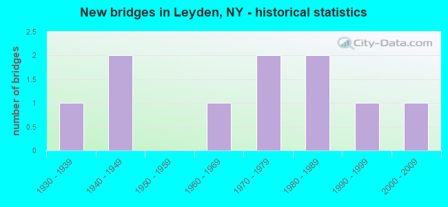
- New bridges - historical statistics
- 11930-1939
- 21940-1949
- 11960-1969
- 21970-1979
- 21980-1989
- 11990-1999
- 12000-2009

- Reconstructed bridges - Historical Statistics
- 11990-1999
- 12000-2009


- Bridge Condition - Deck
- 11.1%Excellent
- 33.3%Very good
- 11.1%Good
- 22.2%Satisfactory
- 11.1%Fair
- 11.1%Poor

- Bridge Condition - Superstructure
- 11.1%Excellent
- 11.1%Very good
- 11.1%Good
- 44.4%Satisfactory
- 11.1%Fair
- 11.1%Poor

- Bridge Condition - Substructure
- 33.3%Very good
- 33.3%Good
- 33.3%Fair

- Bridge Condition - Channel
- 10.0%Very good
- 40.0%Good
- 40.0%Satisfactory
- 10.0%Poor
Find on map >> Show street view
Structure Number: 101001, Location: 6.7 MI S JCT RTS 12D + 26 (Lat: 43.505708, Lng: -75.352742), Route carried "on" structure: Alternate State highway 12D, Year Built: 1970, Status: Open, Structure Length: 1.01m (3.31ft), Average Daily Traffic: 1,617 (year 2015), Truck Traffic: 8%, Average Future Daily Traffic: 1,686 (year 2040), Features Intersected: MOOSE CREEK
Minimum Vertical Clearance: 30+ m (98+ ft), Kilometerpoint: 0.145, Lanes on structure: 2, Base Highway Network: Yes, Owner: State Highway Agency, Approaching Roadway Width: 13.4m (44.0ft), Material/Design: Steel, Design/Construction: Culvert, Number Of Spans In Main Unit: 2, Length of Maximum Span: 4.5m (14.8ft)
Condition: Channel: Good, Culverts: Fair, Operating Rating: 75.8 metric tons, Method Used To Determine Operating Rating: Field evaluation and documented engineering judgment, Inventory Rating: 32.7 metric tons, Method Used To Determine Inventory Rating: Field evaluation and documented engineering judgment, Structural Evaluation: Somewhat better than minimum adequacy, Waterway Adequacy: Superior to present desirable criteria, Approach Roadway Alignment: Equal to present desirable criteria, Length Of Structure Improvement: 1.00m (3.28ft), Designated Inspection Frequency: Every 24 months, Inspection Date: June 2020, Bridge Improvement Cost: $270,000, Roadway Improvement Cost: $158,000, Total Project Cost: $428,000 ( Estimate for 2021), Wearing Surface/Protective System: Wearing Surface: Bituminous
Find on map >> Show street view
Structure Number: 101002, Location: 4.5 MI S JCT 12D + 26 (Lat: 43.538189, Lng: -75.366108), Route carried "on" structure: Alternate State highway 12D, Year Built: 1970, Status: Open, Structure Length: 8.11m (26.61ft), Average Daily Traffic: 971 (year 2020), Truck Traffic: 12%, Average Future Daily Traffic: 1,012 (year 2040), Design Load: HS 20, Features Intersected: SUGAR RIVER
Minimum Vertical Clearance: 30+ m (98+ ft), Kilometerpoint: 3.974, Lanes on structure: 2, Base Highway Network: Yes, Owner: State Highway Agency, Approaching Roadway Width: 14.6m (47.9ft), Skew: 1 degrees, Material/Design: Steel, Design/Construction: Stringer/Multi-beam, Number Of Spans In Main Unit: 3, Length of Maximum Span: 37.7m (123.7ft), Curb-To-Curb Width: 14.3m (46.9ft), Out-to-Out Width: 15.2m (49.9ft)
Condition: Deck: Satisfactory, Superstructure: Satisfactory, Substructure: Fair, Channel: Good, Operating Rating: 62.6 metric tons, Method Used To Determine Operating Rating: Load Factor (LF), Inventory Rating: 33.6 metric tons, Method Used To Determine Inventory Rating: Load Factor (LF), Structural Evaluation: Somewhat better than minimum adequacy, Deck Geometry: Superior to present desirable criteria, Waterway Adequacy: Equal to present minimum criteria, Approach Roadway Alignment: Equal to present desirable criteria, Length Of Structure Improvement: 8.10m (26.57ft), Designated Inspection Frequency: Every 24 months, Inspection Date: August 2021, Bridge Improvement Cost: $2,339,000, Roadway Improvement Cost: $1,370,000, Total Project Cost: $3,709,000 ( Estimate for 2021), Deck Structure Type: Concrete Cast-file-Place, Wearing Surface/Protective System: Wearing Surface: Integral Concrete
Find on map >> Show street view
Structure Number: 109463, Location: 7.1 MI S JCT 12 + 12D (Lat: 43.525422, Lng: -75.324819), Route carried "on" structure: State highway 12, Year Built: 1968, Status: Open, Structure Length: 8.29m (27.20ft), Average Daily Traffic: 4,448 (year 2016), Truck Traffic: 15%, Average Future Daily Traffic: 4,490 (year 2040), Features Intersected: SUGAR RIVER
Minimum Vertical Clearance: 30+ m (98+ ft), Kilometerpoint: 0.965, Lanes on structure: 2, Base Highway Network: Yes, Owner: State Highway Agency, Approaching Roadway Width: 13.4m (44.0ft), Skew: 2 degrees, Material/Design: Steel continuous, Design/Construction: Stringer/Multi-beam, Number Of Spans In Main Unit: 3, Length of Maximum Span: 31.0m (101.7ft), Curb or Sidewalk Widths: Left: 0.5m (1.6ft), Right: 0.5m (1.6ft), Curb-To-Curb Width: 8.5m (27.9ft), Out-to-Out Width: 10.1m (33.1ft)
Condition: Deck: Satisfactory, Superstructure: Good, Substructure: Good, Channel: Satisfactory, Operating Rating: 42.1 metric tons, Method Used To Determine Operating Rating: Load and Resistance Factor Rating (LRFR) rating reported by rating factor(RF) method using HL-93 loadings, Inventory Rating: 32.7 metric tons, Method Used To Determine Inventory Rating: Load and Resistance Factor Rating (LRFR) rating reported by rating factor(RF) method using HL-93 loadings, Structural Evaluation: Better than present minimum criteria, Deck Geometry: Meets minimum limits, Waterway Adequacy: Somewhat better than minimum adequacy, Approach Roadway Alignment: Equal to present desirable criteria, Length Of Structure Improvement: 8.29m (27.20ft), Designated Inspection Frequency: Every 24 months, Critical Feature Inspection Frequency: Every 24 months, Inspection Date: July 2021, Critical Feature Inspection Date: July 2021, Bridge Improvement Cost: $1,574,000, Roadway Improvement Cost: $922,000, Total Project Cost: $2,496,000 ( Estimate for 2021), Deck Structure Type: Concrete Cast-file-Place, Wearing Surface/Protective System: Wearing Surface: Bituminous
Find on map >> Show street view
Structure Number: 222052, Location: 2.4 MI S OF TALCOTTVILLE (Lat: 43.503594, Lng: -75.366275), Route carried "on" structure: Other road , Year Built: 1995, Status: Open, Structure Length: 1.28m (4.20ft), Average Daily Traffic: 68 (year 2015), Truck Traffic: 7%, Average Future Daily Traffic: 95 (year 2035), Features Intersected: N BR MOOSE CREEK, Facility Carried by Structure: BROCK ROAD
Minimum Vertical Clearance: 30+ m (98+ ft), Kilometerpoint: 1.110, Lanes on structure: 2, Owner: Town or Township Highway Agency, Approaching Roadway Width: 6.1m (20.0ft), Material/Design: Steel, Design/Construction: Stringer/Multi-beam, Number Of Spans In Main Unit: 1, Length of Maximum Span: 11.9m (39.0ft), Curb-To-Curb Width: 7.3m (24.0ft), Out-to-Out Width: 7.6m (24.9ft)
Condition: Deck: Very good, Superstructure: Satisfactory, Substructure: Very good, Channel: Satisfactory, Operating Rating: 30.5 metric tons, Method Used To Determine Operating Rating: Load and Resistance Factor Rating (LRFR) rating reported by rating factor(RF) method using HL-93 loadings, Inventory Rating: 23.3 metric tons, Method Used To Determine Inventory Rating: Load and Resistance Factor Rating (LRFR) rating reported by rating factor(RF) method using HL-93 loadings, Structural Evaluation: Equal to present minimum criteria, Deck Geometry: Equal to present minimum criteria, Waterway Adequacy: Meets minimum limits, Approach Roadway Alignment: Meets minimum limits, Length Of Structure Improvement: 1.18m (3.87ft), Designated Inspection Frequency: Every 24 months, Inspection Date: May 2021, Bridge Improvement Cost: $275,000, Roadway Improvement Cost: $161,000, Total Project Cost: $435,000 ( Estimate for 2021), Deck Structure Type: Concrete Cast-file-Place, Wearing Surface/Protective System: Wearing Surface: Bituminous
Find on map >> Show street view
Structure Number: 333963, Location: 2.1 MI SE CONSTABLEVILLE (Lat: 43.546408, Lng: -75.401389), Route carried "on" structure: County highway , Year Built: 1940, Year Reconstructed: 2009, Status: Open, Structure Length: 1.37m (4.49ft), Average Daily Traffic: 639 (year 2020), Truck Traffic: 10%, Average Future Daily Traffic: 895 (year 2040), Features Intersected: OLMSTEAD BROOK, Facility Carried by Structure: COUNTY ROAD 50
Minimum Vertical Clearance: 30+ m (98+ ft), Kilometerpoint: 4.875, Lanes on structure: 2, Owner: County Highway Agency, Approaching Roadway Width: 6.7m (22.0ft), Material/Design: Steel, Design/Construction: Stringer/Multi-beam, Number Of Spans In Main Unit: 1, Length of Maximum Span: 12.1m (39.7ft), Curb-To-Curb Width: 7.2m (23.6ft), Out-to-Out Width: 7.5m (24.6ft)
Condition: Deck: Very good, Superstructure: Satisfactory, Substructure: Fair, Channel: Poor, Operating Rating: 36.3 metric tons, Method Used To Determine Operating Rating: Load Factor (LF), Inventory Rating: 21.8 metric tons, Method Used To Determine Inventory Rating: Load Factor (LF), Structural Evaluation: Somewhat better than minimum adequacy, Deck Geometry: Meets minimum limits, Waterway Adequacy: Superior to present desirable criteria, Approach Roadway Alignment: Better than present minimum criteria, Length Of Structure Improvement: 1.37m (4.49ft), Designated Inspection Frequency: Every 24 months, Inspection Date: June 2020, Bridge Improvement Cost: $250,000, Roadway Improvement Cost: $146,000, Total Project Cost: $397,000 ( Estimate for 2021), Deck Structure Type: Corrugated Steel, Wearing Surface/Protective System: Wearing Surface: Bituminous
Find on map >> Show street view
Structure Number: 333964, Location: 1.5 MI SW OF LOCUST GROVE (Lat: 43.549544, Lng: -75.398581), Route carried "on" structure: Other road , Year Built: 2007, Status: Open, Structure Length: 3.35m (10.99ft), Average Daily Traffic: 120 (year 2015), Truck Traffic: 7%, Average Future Daily Traffic: 168 (year 2035), Design Load: HS 25 or greater, Features Intersected: SUGAR RIVER, Facility Carried by Structure: BAILEY ROAD
Minimum Vertical Clearance: 30+ m (98+ ft), Kilometerpoint: 2.510, Lanes on structure: 2, Owner: County Highway Agency, Approaching Roadway Width: 7.6m (24.9ft), Skew: 2 degrees, Material/Design: Prestressed concrete, Design/Construction: Box Beam or Girders - Multiple, Number Of Spans In Main Unit: 1, Length of Maximum Span: 32.6m (107.0ft), Curb-To-Curb Width: 7.7m (25.3ft), Out-to-Out Width: 8.7m (28.5ft)
Condition: Deck: Excellent, Superstructure: Excellent, Substructure: Very good, Channel: Good, Operating Rating: 96.6 metric tons, Method Used To Determine Operating Rating: Load and Resistance Factor Rating (LRFR) rating reported by rating factor(RF) method using HL-93 loadings, Inventory Rating: 69.7 metric tons, Method Used To Determine Inventory Rating: Load and Resistance Factor Rating (LRFR) rating reported by rating factor(RF) method using HL-93 loadings, Structural Evaluation: Equal to present desirable criteria, Deck Geometry: Somewhat better than minimum adequacy, Waterway Adequacy: Equal to present minimum criteria, Approach Roadway Alignment: Equal to present desirable criteria, Length Of Structure Improvement: 3.35m (10.99ft), Designated Inspection Frequency: Every 24 months, Inspection Date: May 2021, Bridge Improvement Cost: $441,000, Roadway Improvement Cost: $258,000, Total Project Cost: $699,000 ( Estimate for 2021), Wearing Surface/Protective System: Wearing Surface: Bituminous, Membrane: Other
Find on map >> Show street view
Structure Number: 333965, Location: 3.9 MI S OF PORT LEYDEN (Lat: 43.532244, Lng: -75.308392), Route carried "on" structure: Other road , Year Built: 1987, Status: Open, Structure Length: 6.19m (20.31ft), Average Daily Traffic: 208 (year 2020), Truck Traffic: 7%, Average Future Daily Traffic: 291 (year 2040), Design Load: HS 20, Features Intersected: BLACK RIVER, Facility Carried by Structure: NORTON ROAD
Minimum Vertical Clearance: 30+ m (98+ ft), Kilometerpoint: 1.561, Lanes on structure: 1, Owner: County Highway Agency, Approaching Roadway Width: 4.9m (16.1ft), Material/Design: Steel, Design/Construction: Stringer/Multi-beam, Number Of Spans In Main Unit: 2, Length of Maximum Span: 30.2m (99.1ft), Curb-To-Curb Width: 4.9m (16.1ft), Out-to-Out Width: 5.5m (18.0ft)
Condition: Deck: Very good, Superstructure: Very good, Substructure: Very good, Channel: Very good, Operating Rating: 53.1 metric tons, Method Used To Determine Operating Rating: Load and Resistance Factor Rating (LRFR) rating reported by rating factor(RF) method using HL-93 loadings, Inventory Rating: 40.8 metric tons, Method Used To Determine Inventory Rating: Load and Resistance Factor Rating (LRFR) rating reported by rating factor(RF) method using HL-93 loadings, Structural Evaluation: Equal to present desirable criteria, Deck Geometry: High priority of replacement, Waterway Adequacy: Equal to present minimum criteria, Approach Roadway Alignment: Meets minimum limits, Length Of Structure Improvement: 6.18m (20.28ft), Designated Inspection Frequency: Every 24 months, Inspection Date: June 2021, Bridge Improvement Cost: $665,000, Roadway Improvement Cost: $389,000, Total Project Cost: $1,054,000 ( Estimate for 2021), Deck Structure Type: Concrete Cast-file-Place, Wearing Surface/Protective System: Wearing Surface: Integral Concrete
Find on map >> Show street view
Structure Number: 333966, Location: 1.3 MI N OF PORT LEYDEN (Lat: 43.596444, Lng: -75.346967), Route carried "on" structure: Other road , Year Built: 1987, Status: Open, Structure Length: 2.41m (7.91ft), Average Daily Traffic: 212 (year 2020), Truck Traffic: 2%, Average Future Daily Traffic: 297 (year 2040), Features Intersected: BLACK RIVER, Facility Carried by Structure: DAVIS BRIDGE ROAD
Minimum Vertical Clearance: 30+ m (98+ ft), Kilometerpoint: 0.628, Lanes on structure: 1, Owner: County Highway Agency, Approaching Roadway Width: 4.9m (16.1ft), Material/Design: Steel, Design/Construction: Stringer/Multi-beam, Number Of Spans In Main Unit: 1, Length of Maximum Span: 23.1m (75.8ft), Curb-To-Curb Width: 4.8m (15.7ft), Out-to-Out Width: 5.0m (16.4ft)
Condition: Deck: Poor, Superstructure: Fair, Substructure: Good, Channel: Good, Operating Rating: 37.2 metric tons, Method Used To Determine Operating Rating: Load Factor (LF), Inventory Rating: 21.8 metric tons, Method Used To Determine Inventory Rating: Load Factor (LF), Structural Evaluation: Somewhat better than minimum adequacy, Deck Geometry: High priority of corrective action, Waterway Adequacy: Somewhat better than minimum adequacy, Approach Roadway Alignment: High priority of corrective action, Length Of Structure Improvement: 2.40m (7.87ft), Designated Inspection Frequency: Every 24 months, Inspection Date: June 2020, Bridge Improvement Cost: $323,000, Roadway Improvement Cost: $189,000, Total Project Cost: $511,000 ( Estimate for 2021), Deck Structure Type: Open Grating, Wearing Surface/Protective System: Wearing Surface: Other
Find on map >> Show street view
Structure Number: 333969, Location: .9 MI E OF TALCOTTVILLE (Lat: 43.531817, Lng: -75.350086), Route carried "on" structure: County highway , Year Built: 1940, Year Reconstructed: 1995, Status: Open, Structure Length: 2.32m (7.61ft), Average Daily Traffic: 229 (year 2017), Truck Traffic: 3%, Average Future Daily Traffic: 321 (year 2037), Features Intersected: SUGAR RIVER, Facility Carried by Structure: COUNTY ROAD 43
Minimum Vertical Clearance: 30+ m (98+ ft), Kilometerpoint: 2.590, Lanes on structure: 2, Owner: County Highway Agency, Approaching Roadway Width: 6.1m (20.0ft), Material/Design: Steel, Design/Construction: Girder and Floorbeam System, Number Of Spans In Main Unit: 1, Length of Maximum Span: 22.2m (72.8ft), Curb-To-Curb Width: 6.7m (22.0ft), Out-to-Out Width: 7.6m (24.9ft)
Condition: Deck: Good, Superstructure: Satisfactory, Substructure: Good, Channel: Satisfactory, Operating Rating: 39.0 metric tons, Method Used To Determine Operating Rating: Load Factor (LF), Inventory Rating: 26.3 metric tons, Method Used To Determine Inventory Rating: Load Factor (LF), Structural Evaluation: Equal to present minimum criteria, Deck Geometry: Meets minimum limits, Waterway Adequacy: Somewhat better than minimum adequacy, Approach Roadway Alignment: Somewhat better than minimum adequacy, Length Of Structure Improvement: 2.31m (7.58ft), Designated Inspection Frequency: Every 24 months, Critical Feature Inspection Frequency: Every 24 months, Inspection Date: September 2021, Critical Feature Inspection Date: September 2021, Bridge Improvement Cost: $483,000, Roadway Improvement Cost: $283,000, Total Project Cost: $766,000 ( Estimate for 2021), Deck Structure Type: Concrete Cast-file-Place, Wearing Surface/Protective System: Wearing Surface: Integral Concrete
Find on map >> Show street view
Structure Number: 33397, Location: 1.6 MI SE OF TALCOTTVILLE (Lat: 43.521769, Lng: -75.345281), Route carried "on" structure: County highway , Year Built: 1937, Status: Posted for load, Structure Length: 1.71m (5.61ft), Average Daily Traffic: 229 (year 2017), Truck Traffic: 3%, Average Future Daily Traffic: 321 (year 2037), Design Load: H 20, Features Intersected: MOOSE CREEK, Facility Carried by Structure: COUNTY ROAD 43
Minimum Vertical Clearance: 30+ m (98+ ft), Kilometerpoint: 1.384, Lanes on structure: 2, Owner: County Highway Agency, Approaching Roadway Width: 7.3m (24.0ft), Material/Design: Steel, Design/Construction: Girder and Floorbeam System, Number Of Spans In Main Unit: 1, Length of Maximum Span: 16.4m (53.8ft), Curb-To-Curb Width: 7.3m (24.0ft), Out-to-Out Width: 8.3m (27.2ft)
Condition: Deck: Fair, Superstructure: Poor, Substructure: Fair, Channel: Satisfactory, Operating Rating: 21.8 metric tons, Method Used To Determine Operating Rating: Load Factor (LF), Inventory Rating: 12.7 metric tons, Method Used To Determine Inventory Rating: Load Factor (LF), Structural Evaluation: Meets minimum limits, Deck Geometry: Somewhat better than minimum adequacy, Waterway Adequacy: Somewhat better than minimum adequacy, Approach Roadway Alignment: Equal to present minimum criteria, Bridge Posting: Required (Relationship of Operating Rating to Maximum Legal Load: > 39.9% below), Length Of Structure Improvement: 1.70m (5.58ft), Designated Inspection Frequency: Every 12 months, Critical Feature Inspection Frequency: Every 12 months, Inspection Date: May 2021, Critical Feature Inspection Date: May 2021, Bridge Improvement Cost: $410,000, Roadway Improvement Cost: $240,000, Total Project Cost: $650,000 ( Estimate for 2021), Deck Structure Type: Concrete Cast-file-Place, Wearing Surface/Protective System: Wearing Surface: Integral Concrete