Bridge Statistics for Le Roy, New York (NY)
Condition, Traffic, Stress, Structural Evaluation, Project Costs
- National Bridge Inventory (NBI) Statistics
- 16Number of bridges
- 148ft / 45.5mTotal length
- $23,321,000Total costs
- 88,006Total average daily traffic
- 2,552Total average daily truck traffic
- National Bridge Inventory (NBI) Registered Bridges for Le Roy
- No street view available for this location
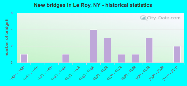
- New bridges - historical statistics
- 11900-1909
- 11930-1939
- 41950-1959
- 31960-1969
- 11970-1979
- 11980-1989
- 31990-1999
- 22010-2019

- Reconstructed bridges - Historical Statistics
- 11960-1969
- 01970-1979
- 11980-1989


- Bridge Condition - Deck
- 18.2%Very good
- 9.1%Good
- 36.4%Satisfactory
- 27.3%Fair
- 9.1%Poor

- Bridge Condition - Superstructure
- 9.1%Excellent
- 9.1%Very good
- 9.1%Good
- 45.5%Satisfactory
- 27.3%Fair

- Bridge Condition - Substructure
- 18.2%Very good
- 54.5%Good
- 18.2%Satisfactory
- 9.1%Fair

- Bridge Condition - Channel
- 37.5%Very good
- 62.5%Good
Find on map >> Show street view
Structure Number: 100174, Location: JCT RTE 5 & OATKA CREEK (Lat: 42.977622, Lng: -77.988581), Route carried "on" structure: State highway 5, Year Built: 1976, Status: Open, Structure Length: 3.05m (10.01ft), Average Daily Traffic: 4,794 (year 2018), Truck Traffic: 6%, Average Future Daily Traffic: 4,823 (year 2040), Design Load: HS 20, Features Intersected: OATKA CREEK
Minimum Vertical Clearance: 30+ m (98+ ft), Kilometerpoint: 39.597, Lanes on structure: 4, Base Highway Network: Yes, Owner: State Highway Agency, Approaching Roadway Width: 18.6m (61.0ft), Skew: 20 degrees, Material/Design: Concrete, Design/Construction: Frame, Number Of Spans In Main Unit: 1, Length of Maximum Span: 28.0m (91.9ft), Curb or Sidewalk Widths: Left: 3.2m (10.5ft), Right: 2.4m (7.9ft), Curb-To-Curb Width: 18.6m (61.0ft), Out-to-Out Width: 25.0m (82.0ft)
Condition: Deck: Very good, Superstructure: Very good, Substructure: Very good, Channel: Very good, Operating Rating: 92.5 metric tons, Method Used To Determine Operating Rating: Field evaluation and documented engineering judgment, Inventory Rating: 32.7 metric tons, Method Used To Determine Inventory Rating: Field evaluation and documented engineering judgment, Structural Evaluation: Equal to present desirable criteria, Deck Geometry: Equal to present minimum criteria, Waterway Adequacy: Equal to present minimum criteria, Approach Roadway Alignment: Equal to present desirable criteria, Length Of Structure Improvement: 3.04m (9.97ft), Designated Inspection Frequency: Every 24 months, Inspection Date: July 2021, Bridge Improvement Cost: $2,328,000, Roadway Improvement Cost: $1,363,000, Total Project Cost: $3,692,000 ( Estimate for 2021)
Find on map >> Show street view
Structure Number: 100175, Location: 1.9 MI E RTS 5 + 19 LEROY (Lat: 42.979706, Lng: -77.950067), Route carried "on" structure: State highway 5, Year Built: 1957, Status: Open, Structure Length: 0.82m (2.69ft), Average Daily Traffic: 2,987 (year 2017), Truck Traffic: 8%, Average Future Daily Traffic: 3,005 (year 2040), Design Load: H 20, Features Intersected: MUD CREEK
Minimum Vertical Clearance: 30+ m (98+ ft), Kilometerpoint: 42.799, Lanes on structure: 2, Base Highway Network: Yes, Owner: State Highway Agency, Approaching Roadway Width: 12.8m (42.0ft), Material/Design: Concrete, Design/Construction: Slab, Number Of Spans In Main Unit: 1, Length of Maximum Span: 7.6m (24.9ft), Curb-To-Curb Width: 12.6m (41.3ft), Out-to-Out Width: 13.7m (44.9ft)
Condition: Deck: Fair, Superstructure: Fair, Substructure: Good, Channel: Good, Operating Rating: 49.9 metric tons, Method Used To Determine Operating Rating: Load Factor (LF), Inventory Rating: 29.0 metric tons, Method Used To Determine Inventory Rating: Load Factor (LF), Structural Evaluation: Somewhat better than minimum adequacy, Deck Geometry: Equal to present minimum criteria, Waterway Adequacy: Somewhat better than minimum adequacy, Approach Roadway Alignment: Equal to present desirable criteria, Length Of Structure Improvement: 0.82m (2.69ft), Designated Inspection Frequency: Every 24 months, Inspection Date: August 2020, Bridge Improvement Cost: $376,000, Roadway Improvement Cost: $220,000, Total Project Cost: $596,000 ( Estimate for 2021), Wearing Surface/Protective System: Wearing Surface: Bituminous
Find on map >> Show street view
Structure Number: 101523, Location: .3MI S OF INT RTES 19 & 5 (Lat: 42.974672, Lng: -77.992319), Route carried "on" structure: State highway 19, Year Built: 1990, Status: Open, Structure Length: 6.89m (22.60ft), Average Daily Traffic: 7,309 (year 2020), Truck Traffic: 9%, Average Future Daily Traffic: 7,354 (year 2040), Design Load: HS 20, Features Intersected: OATKA CREEK
Minimum Vertical Clearance: 30+ m (98+ ft), Kilometerpoint: 13.001, Lanes on structure: 2, Base Highway Network: Yes, Owner: State Highway Agency, Approaching Roadway Width: 9.8m (32.2ft), Material/Design: Prestressed concrete, Design/Construction: Box Beam or Girders - Multiple, Number Of Spans In Main Unit: 3, Length of Maximum Span: 23.2m (76.1ft), Curb or Sidewalk Widths: Left: 1.5m (4.9ft), Right: 1.5m (4.9ft), Curb-To-Curb Width: 9.8m (32.2ft), Out-to-Out Width: 13.4m (44.0ft)
Condition: Deck: Good, Superstructure: Satisfactory, Substructure: Good, Channel: Very good, Operating Rating: 74.4 metric tons, Method Used To Determine Operating Rating: Load Factor (LF), Inventory Rating: 32.7 metric tons, Method Used To Determine Inventory Rating: Load Factor (LF), Structural Evaluation: Equal to present minimum criteria, Deck Geometry: Meets minimum limits, Waterway Adequacy: Equal to present minimum criteria, Approach Roadway Alignment: Equal to present desirable criteria, Length Of Structure Improvement: 6.88m (22.57ft), Designated Inspection Frequency: Every 24 months, Underwater Inspection Frequency: Every 60 months, Inspection Date: September 2020, Underwater Inspection Date: June 2018, Bridge Improvement Cost: $2,320,000, Roadway Improvement Cost: $1,359,000, Total Project Cost: $3,678,000 ( Estimate for 2021), Deck Structure Type: Concrete Cast-file-Place, Wearing Surface/Protective System: Wearing Surface: Bituminous, Deck Protection: Epoxy Coated Reinforcing
Find on map >> Show street view
Structure Number: 101525, Location: JCT RTS 19 & I90-LEROY (Lat: 43.028917, Lng: -77.971231), Route carried "on" structure: State highway 19, Year Built: 1998, Status: Open, Structure Length: 8.69m (28.51ft), Average Daily Traffic: 7,419 (year 2020), Truck Traffic: 13%, Average Future Daily Traffic: 7,464 (year 2040), Design Load: HS 25 or greater, Features Intersected: 90IX, RTE I90
Minimum Vertical Clearance: 30+ m (98+ ft), Kilometerpoint: 19.469, Lanes on structure: 2, Lanes under structure: 6, Base Highway Network: Yes, Owner: State Toll Authority, Approaching Roadway Width: 11.0m (36.1ft), Skew: 2 degrees, Material/Design: Steel continuous, Design/Construction: Stringer/Multi-beam, Number Of Spans In Main Unit: 2, Length of Maximum Span: 42.7m (140.1ft), Curb-To-Curb Width: 11.0m (36.1ft), Out-to-Out Width: 11.8m (38.7ft)
Condition: Deck: Satisfactory, Superstructure: Satisfactory, Substructure: Good, Operating Rating: 73.5 metric tons, Method Used To Determine Operating Rating: Load Factor (LF), Inventory Rating: 44.5 metric tons, Method Used To Determine Inventory Rating: Load Factor (LF), Structural Evaluation: Equal to present minimum criteria, Deck Geometry: Meets minimum limits, Underclear: High priority of corrective action, Approach Roadway Alignment: Equal to present desirable criteria, Length Of Structure Improvement: 8.68m (28.48ft), Designated Inspection Frequency: Every 24 months, Inspection Date: July 2020, Bridge Improvement Cost: $2,459,000, Roadway Improvement Cost: $1,440,000, Total Project Cost: $3,899,000 ( Estimate for 2021), Deck Structure Type: Concrete Cast-file-Place, Wearing Surface/Protective System: Wearing Surface: Integral Concrete, Deck Protection: Galvanized Reinforcing
Find on map >> Show street view
Structure Number: 331606, Location: 3.1 MI NE OF LE ROY (Lat: 43.013769, Lng: -77.955075), Route carried "on" structure: County highway , Year Built: 1989, Status: Open, Structure Length: 2.83m (9.28ft), Average Daily Traffic: 572 (year 2017), Truck Traffic: 7%, Average Future Daily Traffic: 801 (year 2037), Design Load: HS 20, Features Intersected: OATKA CREEK, Facility Carried by Structure: CIRCULAR HILL RD
Minimum Vertical Clearance: 30+ m (98+ ft), Kilometerpoint: 2.558, Lanes on structure: 2, Owner: County Highway Agency, Approaching Roadway Width: 9.1m (29.9ft), Skew: 2 degrees, Material/Design: Prestressed concrete, Design/Construction: Box Beam or Girders - Multiple, Number Of Spans In Main Unit: 1, Length of Maximum Span: 27.7m (90.9ft), Curb-To-Curb Width: 9.1m (29.9ft), Out-to-Out Width: 9.8m (32.2ft)
Condition: Deck: Fair, Superstructure: Good, Substructure: Good, Channel: Very good, Operating Rating: 88.9 metric tons, Method Used To Determine Operating Rating: Load Factor (LF), Inventory Rating: 32.7 metric tons, Method Used To Determine Inventory Rating: Load Factor (LF), Structural Evaluation: Better than present minimum criteria, Deck Geometry: Equal to present minimum criteria, Waterway Adequacy: Better than present minimum criteria, Approach Roadway Alignment: Equal to present desirable criteria, Length Of Structure Improvement: 2.83m (9.28ft), Designated Inspection Frequency: Every 24 months, Inspection Date: May 2021, Bridge Improvement Cost: $737,000, Roadway Improvement Cost: $432,000, Total Project Cost: $1,169,000 ( Estimate for 2021), Deck Structure Type: Concrete Cast-file-Place, Wearing Surface/Protective System: Wearing Surface: Integral Concrete, Deck Protection: Epoxy Coated Reinforcing
Find on map >> Show street view
Structure Number: 331608, Location: 2.0 MI N LEROY (Lat: 43.003886, Lng: -77.976494), Route carried "on" structure: Other road , Year Built: 1964, Status: Open, Structure Length: 1.58m (5.18ft), Average Daily Traffic: 1,313 (year 2017), Truck Traffic: 2%, Average Future Daily Traffic: 1,838 (year 2037), Design Load: HS 20, Features Intersected: OATKA CREEK, Facility Carried by Structure: NORTH STREET ROAD
Minimum Vertical Clearance: 30+ m (98+ ft), Kilometerpoint: 1.641, Lanes on structure: 2, Owner: County Highway Agency, Approaching Roadway Width: 6.7m (22.0ft), Material/Design: Prestressed concrete, Design/Construction: Box Beam or Girders - Multiple, Number Of Spans In Main Unit: 1, Length of Maximum Span: 15.5m (50.9ft), Curb-To-Curb Width: 7.0m (23.0ft), Out-to-Out Width: 7.3m (24.0ft)
Condition: Deck: Satisfactory, Superstructure: Fair, Substructure: Good, Channel: Good, Operating Rating: 73.9 metric tons, Method Used To Determine Operating Rating: Load and Resistance Factor Rating (LRFR) rating reported by rating factor(RF) method using HL-93 loadings, Inventory Rating: 57.0 metric tons, Method Used To Determine Inventory Rating: Load and Resistance Factor Rating (LRFR) rating reported by rating factor(RF) method using HL-93 loadings, Structural Evaluation: Somewhat better than minimum adequacy, Deck Geometry: High priority of corrective action, Waterway Adequacy: Equal to present minimum criteria, Approach Roadway Alignment: Meets minimum limits, Length Of Structure Improvement: 1.58m (5.18ft), Designated Inspection Frequency: Every 24 months, Inspection Date: April 2021, Bridge Improvement Cost: $456,000, Roadway Improvement Cost: $267,000, Total Project Cost: $723,000 ( Estimate for 2021), Wearing Surface/Protective System: Wearing Surface: Bituminous, Membrane: Preformed Fabric
Find on map >> Show street view
Structure Number: 331611, Location: .7 MILE SW OF LEROY (Lat: 42.971681, Lng: -78.002550), Route carried "on" structure: Other road , Year Built: 1966, Status: Open, Structure Length: 3.90m (12.80ft), Average Daily Traffic: 1,169 (year 2017), Truck Traffic: 3%, Average Future Daily Traffic: 1,637 (year 2037), Design Load: HS 20, Features Intersected: OATKA CREEK, Facility Carried by Structure: MUNSON ROAD
Minimum Vertical Clearance: 30+ m (98+ ft), Kilometerpoint: 0.772, Lanes on structure: 2, Owner: County Highway Agency, Approaching Roadway Width: 7.0m (23.0ft), Material/Design: Prestressed concrete, Design/Construction: Box Beam or Girders - Multiple, Number Of Spans In Main Unit: 2, Length of Maximum Span: 18.3m (60.0ft), Curb or Sidewalk Widths: Left: 1.2m (3.9ft), Right: 0.0m, Curb-To-Curb Width: 8.3m (27.2ft), Out-to-Out Width: 9.8m (32.2ft)
Condition: Deck: Satisfactory, Superstructure: Fair, Substructure: Satisfactory, Channel: Good, Operating Rating: 72.6 metric tons, Method Used To Determine Operating Rating: Load Factor (LF), Inventory Rating: 43.5 metric tons, Method Used To Determine Inventory Rating: Load Factor (LF), Structural Evaluation: Somewhat better than minimum adequacy, Deck Geometry: Meets minimum limits, Waterway Adequacy: Better than present minimum criteria, Approach Roadway Alignment: Equal to present desirable criteria, Length Of Structure Improvement: 3.90m (12.80ft), Designated Inspection Frequency: Every 24 months, Inspection Date: May 2021, Bridge Improvement Cost: $1,069,000, Roadway Improvement Cost: $626,000, Total Project Cost: $1,695,000 ( Estimate for 2021), Wearing Surface/Protective System: Wearing Surface: Bituminous, Membrane: Other
Find on map >> Show street view
Structure Number: 331612, Location: 1.8 MI SOUTH OF LEROY (Lat: 42.955975, Lng: -77.973753), Route carried "on" structure: Other road , Year Built: 1962, Status: Open, Structure Length: 0.85m (2.79ft), Average Daily Traffic: 330 (year 2017), Truck Traffic: 5%, Average Future Daily Traffic: 462 (year 2037), Design Load: HS 20, Features Intersected: MUD CREEK, Facility Carried by Structure: HARRIS ROAD
Minimum Vertical Clearance: 30+ m (98+ ft), Kilometerpoint: 0.451, Lanes on structure: 2, Owner: County Highway Agency, Approaching Roadway Width: 6.1m (20.0ft), Material/Design: Prestressed concrete, Design/Construction: Box Beam or Girders - Multiple, Number Of Spans In Main Unit: 1, Length of Maximum Span: 8.2m (26.9ft), Curb-To-Curb Width: 7.1m (23.3ft), Out-to-Out Width: 7.3m (24.0ft)
Condition: Deck: Satisfactory, Superstructure: Satisfactory, Substructure: Fair, Channel: Good, Operating Rating: 77.8 metric tons, Method Used To Determine Operating Rating: Field evaluation and documented engineering judgment, Inventory Rating: 29.4 metric tons, Method Used To Determine Inventory Rating: Field evaluation and documented engineering judgment, Structural Evaluation: Somewhat better than minimum adequacy, Deck Geometry: Meets minimum limits, Waterway Adequacy: Better than present minimum criteria, Approach Roadway Alignment: Equal to present desirable criteria, Length Of Structure Improvement: 0.85m (2.79ft), Designated Inspection Frequency: Every 24 months, Inspection Date: March 2021, Bridge Improvement Cost: $188,000, Roadway Improvement Cost: $110,000, Total Project Cost: $298,000 ( Estimate for 2021), Wearing Surface/Protective System: Wearing Surface: Bituminous
Find on map >> Show street view
Structure Number: 331613, Location: 2.3 MI SW OF LEROY (Lat: 42.957861, Lng: -78.023744), Route carried "on" structure: Other road , Year Built: 1957, Year Reconstructed: 1972, Status: Open, Structure Length: 2.19m (7.19ft), Average Daily Traffic: 464 (year 2017), Truck Traffic: 8%, Average Future Daily Traffic: 650 (year 2037), Design Load: HS 20, Features Intersected: OATKA CREEK, Facility Carried by Structure: COLE ROAD
Minimum Vertical Clearance: 30+ m (98+ ft), Kilometerpoint: 1.754, Lanes on structure: 2, Owner: County Highway Agency, Approaching Roadway Width: 7.0m (23.0ft), Skew: 1 degrees, Material/Design: Prestressed concrete, Design/Construction: Box Beam or Girders - Single/Spread, Number Of Spans In Main Unit: 1, Length of Maximum Span: 21.3m (69.9ft), Curb-To-Curb Width: 9.8m (32.2ft), Out-to-Out Width: 10.4m (34.1ft)
Condition: Deck: Poor, Superstructure: Satisfactory, Substructure: Satisfactory, Channel: Good, Operating Rating: 53.5 metric tons, Method Used To Determine Operating Rating: Load Factor (LF), Inventory Rating: 31.8 metric tons, Method Used To Determine Inventory Rating: Load Factor (LF), Structural Evaluation: Equal to present minimum criteria, Deck Geometry: Equal to present minimum criteria, Waterway Adequacy: Better than present minimum criteria, Approach Roadway Alignment: Better than present minimum criteria, Length Of Structure Improvement: 2.19m (7.19ft), Designated Inspection Frequency: Every 24 months, Inspection Date: March 2021, Bridge Improvement Cost: $839,000, Roadway Improvement Cost: $491,000, Total Project Cost: $1,330,000 ( Estimate for 2021), Deck Structure Type: Concrete Cast-file-Place, Wearing Surface/Protective System: Wearing Surface: Bituminous
Find on map >> Show street view
Structure Number: 531605, Location: 1.8 MI W JCT RTE 19&I90 (Lat: 43.029628, Lng: -78.004244), Route carried "on" structure: County highway , Year Built: 2015, Status: Open, Structure Length: 7.44m (24.41ft), Average Daily Traffic: 1,117 (year 2017), Truck Traffic: 4%, Average Future Daily Traffic: 1,564 (year 2037), Design Load: HL 93, Features Intersected: 90IX EB, RTE I90, Facility Carried by Structure: WEST BERGEN RD
Minimum Vertical Clearance: 30+ m (98+ ft), Kilometerpoint: 5.101, Lanes on structure: 2, Lanes under structure: 4, Owner: State Toll Authority, Approaching Roadway Width: 9.1m (29.9ft), Material/Design: Steel continuous, Design/Construction: Stringer/Multi-beam, Number Of Spans In Main Unit: 2, Length of Maximum Span: 36.9m (121.1ft), Curb-To-Curb Width: 9.1m (29.9ft), Out-to-Out Width: 10.1m (33.1ft)
Condition: Deck: Very good, Superstructure: Excellent, Substructure: Very good, Operating Rating: 95.3 metric tons, Method Used To Determine Operating Rating: Load Factor (LF), Inventory Rating: 57.2 metric tons, Method Used To Determine Inventory Rating: Load Factor (LF), Structural Evaluation: Equal to present desirable criteria, Deck Geometry: Somewhat better than minimum adequacy, Underclear: High priority of corrective action, Approach Roadway Alignment: Better than present minimum criteria, Length Of Structure Improvement: 7.43m (24.38ft), Designated Inspection Frequency: Every 24 months, Inspection Date: November 2021, Bridge Improvement Cost: $1,720,000, Roadway Improvement Cost: $1,007,000, Total Project Cost: $2,727,000 ( Estimate for 2021), Deck Structure Type: Concrete Cast-file-Place, Wearing Surface/Protective System: Wearing Surface: Integral Concrete, Deck Protection: Galvanized Reinforcing
Find on map >> Show street view
Structure Number: 551692, Location: 0.3 MI E JCT RTE 19 & I90 (Lat: 43.029039, Lng: -77.964617), Route carried "on" structure: Ramp Other road , Year Built: 1954, Year Reconstructed: 1994, Status: Open, Structure Length: 7.22m (23.69ft), Average Daily Traffic: 673 (year 2018), Truck Traffic: 31%, Average Future Daily Traffic: 825 (year 2040), Design Load: HS 20+Mod, Features Intersected: RTE I90, Facility Carried by Structure: 90IX EXIT 47 RAMP
Minimum Vertical Clearance: 30+ m (98+ ft), Kilometerpoint: 0.274, Lanes on structure: 2, Lanes under structure: 5, Owner: State Toll Authority, Approaching Roadway Width: 11.9m (39.0ft), Skew: 20 degrees, Material/Design: Steel, Design/Construction: Stringer/Multi-beam, Number Of Spans In Main Unit: 4, Length of Maximum Span: 25.9m (85.0ft), Curb-To-Curb Width: 12.2m (40.0ft), Out-to-Out Width: 13.1m (43.0ft)
Condition: Deck: Fair, Superstructure: Satisfactory, Substructure: Good, Operating Rating: 79.8 metric tons, Method Used To Determine Operating Rating: Load Factor (LF), Inventory Rating: 48.1 metric tons, Method Used To Determine Inventory Rating: Load Factor (LF), Structural Evaluation: Equal to present minimum criteria, Deck Geometry: Superior to present desirable criteria, Underclear: High priority of corrective action, Approach Roadway Alignment: Equal to present desirable criteria, Length Of Structure Improvement: 7.22m (23.69ft), Designated Inspection Frequency: Every 24 months, Inspection Date: May 2020, Bridge Improvement Cost: $2,216,000, Roadway Improvement Cost: $1,298,000, Total Project Cost: $3,514,000 ( Estimate for 2021), Deck Structure Type: Concrete Cast-file-Place, Wearing Surface/Protective System: Wearing Surface: Bituminous
Find on map >> Show street view
Structure Number: 101525, Location: JCT RTS 19 & I90-LEROY (Lat: 43.028917, Lng: -77.971231), Route carried "under" structure: State highway 90, Year Built: 1998, Structure Length: 0. m, Average Daily Traffic: 18,000 (year 1973), Features Intersected: 90IX, RTE I90, Facility Carried by Structure: RTE 19
Minimum Vertical Clearance: 4.57m (14.99ft), Kilometerpoint: 609.634, Lanes on structure: 2, Lanes under structure: 3, Toll: On Interstate toll segment, Material/Design: Steel continuous, Design/Construction: Stringer/Multi-beam, Length of Maximum Span: 42.7m (140.1ft)
Find on map >> Show street view
Structure Number: 531605, Location: 1.8 MI W JCT RTE 19&I90 (Lat: 43.029628, Lng: -78.004244), Route carried "under" structure: Interstate 90, Year Built: 2015, Structure Length: 0. m, Average Daily Traffic: 16,840 (year 1977), Features Intersected: 90IX EB, RTE I90, Facility Carried by Structure: WEST BERGEN RD
Minimum Vertical Clearance: 5.26m (17.26ft), Kilometerpoint: 612.337, Lanes on structure: 2, Lanes under structure: 2, Toll: On Interstate toll segment, Material/Design: Steel continuous, Design/Construction: Stringer/Multi-beam, Length of Maximum Span: 36.9m (121.1ft)
Find on map >> Show street view
Structure Number: 551692, Location: 0.3 MI E JCT RTE 19 & I90 (Lat: 43.029039, Lng: -77.964617), Route carried "under" structure: Interstate 90, Year Built: 1954, Structure Length: 0. m, Average Daily Traffic: 16,840 (year 2015), Features Intersected: RTE I90
Minimum Vertical Clearance: 4.57m (14.99ft), Kilometerpoint: 609.103, Lanes on structure: 2, Lanes under structure: 5, Toll: On Interstate toll segment, Material/Design: Steel, Design/Construction: Stringer/Multi-beam, Length of Maximum Span: 25.9m (85.0ft)
Find on map >> Show street view
Structure Number: 700173, Location: 0.8 MI W JCT RTS 5 + 19 (Lat: 42.977914, Lng: -78.002147), Route carried "under" structure: Alternate State highway 5, Year Built: 1935, Structure Length: 0. m, Average Daily Traffic: 8,179 (year 1999), Features Intersected: RTE 5, Facility Carried by Structure: ROCHESTER & SOUTH
Minimum Vertical Clearance: 4.26m (13.98ft), Kilometerpoint: 9.976, Lanes under structure: 2, Material/Design: Steel, Design/Construction: Girder and Floorbeam System, Length of Maximum Span: 12.8m (42.0ft)
Find on map >> Show street view
Structure Number: 770719, Location: AT LEROY (Lat: 42.982369, Lng: -77.990494), Route carried "under" structure: Other road , Year Built: 1907, Structure Length: 0. m, Features Intersected: MILL STREET, OATKA CREEK, Facility Carried by Structure: ROCH & SOUTHERN
Minimum Vertical Clearance: 3.96m (12.99ft), Kilometerpoint: 0.000, Lanes under structure: 2, Material/Design: Steel, Length of Maximum Span: 23.7m (77.8ft)