Bridge Statistics for Lansing, New York (NY)
Condition, Traffic, Stress, Structural Evaluation, Project Costs
- National Bridge Inventory (NBI) Statistics
- 14Number of bridges
- 151ft / 46.4mTotal length
- $27,477,000Total costs
- 77,408Total average daily traffic
- 2,305Total average daily truck traffic
- National Bridge Inventory (NBI) Registered Bridges for Lansing
- No street view available for this location
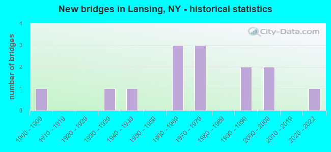
- New bridges - historical statistics
- 11900-1909
- 11930-1939
- 11940-1949
- 31960-1969
- 31970-1979
- 21990-1999
- 22000-2009
- 12020-2022

- Reconstructed bridges - Historical Statistics
- 11950-1959
- 01960-1969
- 01970-1979
- 01980-1989
- 01990-1999
- 02000-2009
- 22010-2019


- Bridge Condition - Deck
- 11.1%Excellent
- 33.3%Very good
- 11.1%Good
- 33.3%Satisfactory
- 11.1%Fair

- Bridge Condition - Superstructure
- 20.0%Excellent
- 10.0%Very good
- 20.0%Good
- 30.0%Satisfactory
- 10.0%Poor
- 10.0%Serious

- Bridge Condition - Substructure
- 10.0%Excellent
- 10.0%Very good
- 40.0%Good
- 10.0%Satisfactory
- 30.0%Fair

- Bridge Condition - Channel
- 10.0%Excellent
- 10.0%Very good
- 30.0%Good
- 20.0%Satisfactory
- 30.0%Fair

- Bridge Condition - Culverts
- 50.0%Very good
- 50.0%Fair
Find on map >> Show street view
Structure Number: 101039, Location: 1.1 MI N JCT SH 13 & SH 3 (Lat: 42.478047, Lng: -76.499281), Route carried "on" structure: County highway , Year Built: 1964, Year Reconstructed: 2015, Status: Open, Structure Length: 6.07m (19.91ft), Average Daily Traffic: 1,643 (year 2020), Truck Traffic: 3%, Average Future Daily Traffic: 2,032 (year 2040), Design Load: HS 20, Features Intersected: RTE 13, Facility Carried by Structure: CAYUGA HEIGHTS RD
Minimum Vertical Clearance: 30+ m (98+ ft), Kilometerpoint: 0.032, Lanes on structure: 2, Lanes under structure: 4, Owner: State Highway Agency, Approaching Roadway Width: 7.3m (24.0ft), Skew: 3 degrees, Material/Design: Steel, Design/Construction: Stringer/Multi-beam, Number Of Spans In Main Unit: 4, Length of Maximum Span: 18.2m (59.7ft), Curb-To-Curb Width: 9.5m (31.2ft), Out-to-Out Width: 10.5m (34.4ft)
Condition: Deck: Very good, Superstructure: Satisfactory, Substructure: Good, Operating Rating: 93.4 metric tons, Method Used To Determine Operating Rating: Load Factor (LF), Inventory Rating: 56.2 metric tons, Method Used To Determine Inventory Rating: Load Factor (LF), Structural Evaluation: Equal to present minimum criteria, Deck Geometry: Somewhat better than minimum adequacy, Underclear: Meets minimum limits, Approach Roadway Alignment: Equal to present desirable criteria, Length Of Structure Improvement: 6.06m (19.88ft), Designated Inspection Frequency: Every 24 months, Inspection Date: September 2020, Bridge Improvement Cost: $1,315,000, Roadway Improvement Cost: $770,000, Total Project Cost: $2,086,000 ( Estimate for 2021), Deck Structure Type: Concrete Cast-file-Place, Wearing Surface/Protective System: Wearing Surface: Integral Concrete, Deck Protection: Epoxy Coated Reinforcing
Find on map >> Show street view
Structure Number: 102328, Location: 4.5 MI N JCT RTS 34 & 13 (Lat: 42.523239, Lng: -76.499789), Route carried "on" structure: State highway 34, Year Built: 1995, Status: Open, Structure Length: 3.17m (10.40ft), Average Daily Traffic: 6,519 (year 2020), Truck Traffic: 11%, Average Future Daily Traffic: 7,919 (year 2040), Design Load: HS 25 or greater, Features Intersected: GULF CREEK
Minimum Vertical Clearance: 30+ m (98+ ft), Kilometerpoint: 30.362, Lanes on structure: 2, Base Highway Network: Yes, Owner: State Highway Agency, Approaching Roadway Width: 13.4m (44.0ft), Skew: 1 degrees, Material/Design: Steel, Design/Construction: Stringer/Multi-beam, Number Of Spans In Main Unit: 1, Length of Maximum Span: 30.4m (99.7ft), Curb-To-Curb Width: 13.5m (44.3ft), Out-to-Out Width: 14.1m (46.3ft)
Condition: Deck: Very good, Superstructure: Very good, Substructure: Very good, Channel: Good, Operating Rating: 78.9 metric tons, Method Used To Determine Operating Rating: Load Factor (LF), Inventory Rating: 47.2 metric tons, Method Used To Determine Inventory Rating: Load Factor (LF), Structural Evaluation: Equal to present desirable criteria, Deck Geometry: Superior to present desirable criteria, Waterway Adequacy: Somewhat better than minimum adequacy, Approach Roadway Alignment: Equal to present desirable criteria, Length Of Structure Improvement: 3.16m (10.37ft), Designated Inspection Frequency: Every 24 months, Inspection Date: August 2021, Bridge Improvement Cost: $1,048,000, Roadway Improvement Cost: $614,000, Total Project Cost: $1,662,000 ( Estimate for 2021), Deck Structure Type: Concrete Cast-file-Place, Wearing Surface/Protective System: Wearing Surface: Integral Concrete, Deck Protection: Epoxy Coated Reinforcing
Find on map >> Show street view
Structure Number: 102338, Location: 1.9 W JCT RTS 34B + 34 (Lat: 42.544278, Lng: -76.540567), Route carried "on" structure: State highway 34B, Year Built: 1930, Status: Posted for load-capacity, Structure Length: 15.30m (50.20ft), Average Daily Traffic: 5,570 (year 2020), Truck Traffic: 10%, Average Future Daily Traffic: 7,787 (year 2040), Features Intersected: SALMON CREEK
Minimum Vertical Clearance: 30+ m (98+ ft), Kilometerpoint: 14.948, Lanes on structure: 2, Base Highway Network: Yes, Owner: State Highway Agency, Approaching Roadway Width: 9.4m (30.8ft), Material/Design: Steel, Design/Construction: Arch - Deck, Number Of Spans In Main Unit: 3, Length of Maximum Span: 81.0m (265.7ft), Curb-To-Curb Width: 8.9m (29.2ft), Out-to-Out Width: 10.0m (32.8ft)
Condition: Deck: Fair, Superstructure: Serious, Substructure: Fair, Channel: Very good, Operating Rating: 88.7 metric tons, Method Used To Determine Operating Rating: Field evaluation and documented engineering judgment, Inventory Rating: 29.4 metric tons, Method Used To Determine Inventory Rating: Field evaluation and documented engineering judgment, Structural Evaluation: High priority of corrective action, Deck Geometry: Meets minimum limits, Waterway Adequacy: Superior to present desirable criteria, Approach Roadway Alignment: Equal to present desirable criteria, Length Of Structure Improvement: 15.30m (50.20ft), Designated Inspection Frequency: Every 24 months, Critical Feature Inspection Frequency: Every 24 months, Inspection Date: November 2021, Critical Feature Inspection Date: November 2021, Bridge Improvement Cost: $7,789,000, Roadway Improvement Cost: $4,561,000, Total Project Cost: $12,350,000 ( Estimate for 2021), Deck Structure Type: Concrete Cast-file-Place, Wearing Surface/Protective System: Wearing Surface: Monolithic Concrete
Find on map >> Show street view
Structure Number: 109372, Location: 1.9 MI E JCT SH 13 & SH34 (Lat: 42.480989, Lng: -76.483808), Route carried "on" structure: County highway , Year Built: 1975, Status: Open, Structure Length: 6.34m (20.80ft), Average Daily Traffic: 11,468 (year 2015), Truck Traffic: 5%, Average Future Daily Traffic: 13,931 (year 2040), Design Load: HS 20, Features Intersected: 13 13 36033021 WB, RTE, Facility Carried by Structure: TRIPHAMMER ROAD
Minimum Vertical Clearance: 30+ m (98+ ft), Kilometerpoint: 0.354, Lanes on structure: 4, Lanes under structure: 4, Owner: State Highway Agency, Approaching Roadway Width: 15.8m (51.8ft), Skew: 2 degrees, Material/Design: Steel continuous, Design/Construction: Stringer/Multi-beam, Number Of Spans In Main Unit: 2, Length of Maximum Span: 31.0m (101.7ft), Curb or Sidewalk Widths: Left: 1.5m (4.9ft), Right: 1.5m (4.9ft), Curb-To-Curb Width: 15.8m (51.8ft), Out-to-Out Width: 19.5m (64.0ft)
Condition: Deck: Satisfactory, Superstructure: Good, Substructure: Good, Operating Rating: 78.9 metric tons, Method Used To Determine Operating Rating: Load Factor (LF), Inventory Rating: 47.2 metric tons, Method Used To Determine Inventory Rating: Load Factor (LF), Structural Evaluation: Better than present minimum criteria, Deck Geometry: Meets minimum limits, Underclear: Equal to present minimum criteria, Approach Roadway Alignment: Equal to present desirable criteria, Length Of Structure Improvement: 6.33m (20.77ft), Designated Inspection Frequency: Every 24 months, Inspection Date: June 2021, Bridge Improvement Cost: $2,701,000, Roadway Improvement Cost: $1,581,000, Total Project Cost: $4,282,000 ( Estimate for 2021), Deck Structure Type: Concrete Cast-file-Place, Wearing Surface/Protective System: Wearing Surface: Integral Concrete
Find on map >> Show street view
Structure Number: 321007, Location: .9 MILE W OF LUDLOWVILLE (Lat: 42.554181, Lng: -76.519933), Route carried "on" structure: Other road , Year Built: 1945, Status: Open, Structure Length: 0.82m (2.69ft), Average Daily Traffic: 237 (year 2016), Truck Traffic: 8%, Average Future Daily Traffic: 332 (year 2036), Features Intersected: TRIB SALMON CREE, Facility Carried by Structure: BUCK ROAD
Minimum Vertical Clearance: 30+ m (98+ ft), Kilometerpoint: 1.255, Lanes on structure: 2, Owner: County Highway Agency, Approaching Roadway Width: 5.5m (18.0ft), Material/Design: Concrete, Design/Construction: Frame, Number Of Spans In Main Unit: 1, Length of Maximum Span: 7.6m (24.9ft), Curb-To-Curb Width: 6.8m (22.3ft), Out-to-Out Width: 7.6m (24.9ft)
Condition: Superstructure: Satisfactory, Substructure: Satisfactory, Channel: Fair, Operating Rating: 72.4 metric tons, Method Used To Determine Operating Rating: Field evaluation and documented engineering judgment, Inventory Rating: 31.5 metric tons, Method Used To Determine Inventory Rating: Field evaluation and documented engineering judgment, Structural Evaluation: Equal to present minimum criteria, Deck Geometry: Meets minimum limits, Waterway Adequacy: Meets minimum limits, Approach Roadway Alignment: Somewhat better than minimum adequacy, Length Of Structure Improvement: 0.82m (2.69ft), Designated Inspection Frequency: Every 24 months, Inspection Date: July 2021, Bridge Improvement Cost: $361,000, Roadway Improvement Cost: $211,000, Total Project Cost: $572,000 ( Estimate for 2021)
Find on map >> Show street view
Structure Number: 321009, Location: IN LUDLOWVILLE (Lat: 42.553858, Lng: -76.535014), Route carried "on" structure: Other road , Year Built: 1900, Year Reconstructed: 1959, Status: Posted for load, Structure Length: 2.47m (8.10ft), Average Daily Traffic: 57 (year 2016), Truck Traffic: 8%, Average Future Daily Traffic: 80 (year 2036), Features Intersected: SALMON CREEK, Facility Carried by Structure: DUG ROAD
Minimum Vertical Clearance: 30+ m (98+ ft), Kilometerpoint: 0.016, Lanes on structure: 1, Owner: County Highway Agency, Approaching Roadway Width: 4.0m (13.1ft), Material/Design: Steel, Design/Construction: Girder and Floorbeam System, Number Of Spans In Main Unit: 1, Length of Maximum Span: 23.7m (77.8ft), Curb-To-Curb Width: 3.4m (11.2ft), Out-to-Out Width: 4.4m (14.4ft)
Condition: Deck: Satisfactory, Superstructure: Poor, Substructure: Fair, Channel: Good, Operating Rating: 23.6 metric tons, Method Used To Determine Operating Rating: Load Factor (LF), Inventory Rating: 13.6 metric tons, Method Used To Determine Inventory Rating: Load Factor (LF), Structural Evaluation: Meets minimum limits, Deck Geometry: High priority of corrective action, Waterway Adequacy: Equal to present desirable criteria, Approach Roadway Alignment: Meets minimum limits, Bridge Posting: Required (Relationship of Operating Rating to Maximum Legal Load: > 39.9% below), Length Of Structure Improvement: 2.46m (8.07ft), Designated Inspection Frequency: Every 12 months, Critical Feature Inspection Frequency: Every 12 months, Inspection Date: October 2021, Critical Feature Inspection Date: October 2021, Bridge Improvement Cost: $334,000, Roadway Improvement Cost: $195,000, Total Project Cost: $529,000 ( Estimate for 2021), Deck Structure Type: Open Grating, Wearing Surface/Protective System: Wearing Surface: Other
Find on map >> Show street view
Structure Number: 32101, Location: .4 MILE N OF LUDLOWVILLE (Lat: 42.558867, Lng: -76.537514), Route carried "on" structure: Other road , Year Built: 1961, Year Reconstructed: 2017, Status: Posted for load, Structure Length: 3.14m (10.30ft), Average Daily Traffic: 201 (year 2016), Truck Traffic: 8%, Average Future Daily Traffic: 281 (year 2036), Features Intersected: SALMON CREEK, Facility Carried by Structure: SALMON CREEK ROAD
Minimum Vertical Clearance: 4.52m (14.83ft), Kilometerpoint: 0.628, Lanes on structure: 1, Owner: County Highway Agency, Approaching Roadway Width: 6.1m (20.0ft), Skew: 3 degrees, Material/Design: Steel, Design/Construction: Truss - Thru, Number Of Spans In Main Unit: 1, Length of Maximum Span: 30.4m (99.7ft), Curb-To-Curb Width: 5.0m (16.4ft), Out-to-Out Width: 5.7m (18.7ft)
Condition: Deck: Good, Superstructure: Satisfactory, Substructure: Fair, Channel: Satisfactory, Operating Rating: 28.1 metric tons, Method Used To Determine Operating Rating: Allowable Stress (AS), Inventory Rating: 20.0 metric tons, Method Used To Determine Inventory Rating: Allowable Stress (AS), Structural Evaluation: Somewhat better than minimum adequacy, Deck Geometry: High priority of replacement, Waterway Adequacy: Better than present minimum criteria, Approach Roadway Alignment: High priority of corrective action, Bridge Posting: Required (Relationship of Operating Rating to Maximum Legal Load: > 39.9% below), Length Of Structure Improvement: 3.13m (10.27ft), Designated Inspection Frequency: Every 12 months, Critical Feature Inspection Frequency: Every 12 months, Inspection Date: May 2021, Critical Feature Inspection Date: May 2021, Bridge Improvement Cost: $1,452,000, Roadway Improvement Cost: $850,000, Total Project Cost: $2,302,000 ( Estimate for 2021), Deck Structure Type: Wood or Timber, Wearing Surface/Protective System: Wearing Surface: Bituminous, Membrane: Epoxy
Find on map >> Show street view
Structure Number: 326311, Location: TOWN OF LANSING (Lat: 42.564703, Lng: -76.531567), Route carried "on" structure: Other road , Year Built: 2000, Status: Open, Structure Length: 0.79m (2.59ft), Average Daily Traffic: 201 (year 2016), Truck Traffic: 8%, Average Future Daily Traffic: 281 (year 2036), Design Load: HS 25 or greater, Features Intersected: TRIB SALMON CREEK, Facility Carried by Structure: SALMON CREEK ROAD
Minimum Vertical Clearance: 30+ m (98+ ft), Kilometerpoint: 1.529, Lanes on structure: 2, Owner: County Highway Agency, Approaching Roadway Width: 6.1m (20.0ft), Material/Design: Concrete, Design/Construction: Culvert, Number Of Spans In Main Unit: 1, Length of Maximum Span: 7.3m (24.0ft), Curb-To-Curb Width: 9.2m (30.2ft), Out-to-Out Width: 10.2m (33.5ft)
Condition: Channel: Fair, Culverts: Very good, Operating Rating: 72.6 metric tons, Method Used To Determine Operating Rating: Load Factor (LF), Inventory Rating: 43.5 metric tons, Method Used To Determine Inventory Rating: Load Factor (LF), Structural Evaluation: Equal to present desirable criteria, Deck Geometry: Equal to present minimum criteria, Waterway Adequacy: Somewhat better than minimum adequacy, Approach Roadway Alignment: Equal to present desirable criteria, Length Of Structure Improvement: 0.79m (2.59ft), Designated Inspection Frequency: Every 24 months, Inspection Date: July 2021, Bridge Improvement Cost: $275,000, Roadway Improvement Cost: $161,000, Total Project Cost: $436,000 ( Estimate for 2021), Wearing Surface/Protective System: Wearing Surface: Bituminous, Membrane: Other
Find on map >> Show street view
Structure Number: 331434, Location: 1 MI SOUTH OF LUDLOWVILLE (Lat: 42.539828, Lng: -76.543969), Route carried "on" structure: Other road , Year Built: 1998, Status: Open, Structure Length: 3.87m (12.70ft), Average Daily Traffic: 215 (year 2016), Truck Traffic: 8%, Average Future Daily Traffic: 301 (year 2036), Design Load: HS 25 or greater, Features Intersected: SALMON CREEK, Facility Carried by Structure: MYERS RD
Minimum Vertical Clearance: 30+ m (98+ ft), Kilometerpoint: 0.756, Lanes on structure: 2, Owner: County Highway Agency, Approaching Roadway Width: 7.3m (24.0ft), Skew: 2 degrees, Material/Design: Steel, Design/Construction: Stringer/Multi-beam, Number Of Spans In Main Unit: 1, Length of Maximum Span: 38.1m (125.0ft), Curb or Sidewalk Widths: Left: 1.5m (4.9ft), Right: 0.0m, Curb-To-Curb Width: 7.3m (24.0ft), Out-to-Out Width: 9.4m (30.8ft)
Condition: Deck: Very good, Superstructure: Excellent, Substructure: Good, Channel: Good, Operating Rating: 40.8 metric tons, Method Used To Determine Operating Rating: Load and Resistance Factor Rating (LRFR) rating reported by rating factor(RF) method using HL-93 loadings, Inventory Rating: 31.4 metric tons, Method Used To Determine Inventory Rating: Load and Resistance Factor Rating (LRFR) rating reported by rating factor(RF) method using HL-93 loadings, Structural Evaluation: Better than present minimum criteria, Deck Geometry: Somewhat better than minimum adequacy, Waterway Adequacy: Meets minimum limits, Approach Roadway Alignment: Equal to present minimum criteria, Length Of Structure Improvement: 3.87m (12.70ft), Designated Inspection Frequency: Every 24 months, Inspection Date: June 2020, Bridge Improvement Cost: $828,000, Roadway Improvement Cost: $485,000, Total Project Cost: $1,312,000 ( Estimate for 2021), Deck Structure Type: Concrete Cast-file-Place, Wearing Surface/Protective System: Wearing Surface: Integral Concrete, Deck Protection: Epoxy Coated Reinforcing
Find on map >> Show street view
Structure Number: 331435, Location: 0.2 MI S of LUDLOWVILLE (Lat: 42.550767, Lng: -76.537900), Route carried "on" structure: County highway , Year Built: 2020, Status: Open, Structure Length: 2.51m (8.23ft), Average Daily Traffic: 734 (year 2018), Truck Traffic: 2%, Average Future Daily Traffic: 1,026 (year 2040), Design Load: HS 25 or greater, Features Intersected: SALMON CREEK, Facility Carried by Structure: LUDLOWVILLE ROAD
Minimum Vertical Clearance: 32.69m (107.25ft), Kilometerpoint: 1.496, Lanes on structure: 2, Owner: County Highway Agency, Approaching Roadway Width: 8.5m (27.9ft), Material/Design: Steel, Design/Construction: Stringer/Multi-beam, Number Of Spans In Main Unit: 1, Length of Maximum Span: 23.8m (78.1ft), Curb-To-Curb Width: 8.5m (27.9ft), Out-to-Out Width: 9.5m (31.2ft)
Condition: Deck: Excellent, Superstructure: Excellent, Substructure: Excellent, Channel: Excellent, Operating Rating: 89.5 metric tons, Method Used To Determine Operating Rating: Field evaluation and documented engineering judgment, Inventory Rating: 40.8 metric tons, Method Used To Determine Inventory Rating: Field evaluation and documented engineering judgment, Structural Evaluation: Superior to present desirable criteria, Deck Geometry: Somewhat better than minimum adequacy, Waterway Adequacy: Superior to present desirable criteria, Approach Roadway Alignment: Equal to present desirable criteria, Designated Inspection Frequency: Every 24 months, Inspection Date: April 2021, Deck Structure Type: Concrete Cast-file-Place, Wearing Surface/Protective System: Wearing Surface: Integral Concrete, Deck Protection: Epoxy Coated Reinforcing
Find on map >> Show street view
Structure Number: 331436, Location: 2.2 MI NORTH OF ITHACA (Lat: 42.526094, Lng: -76.491833), Route carried "on" structure: County highway , Year Built: 2002, Status: Open, Structure Length: 1.25m (4.10ft), Average Daily Traffic: 6,284 (year 2020), Truck Traffic: 4%, Average Future Daily Traffic: 7,633 (year 2040), Design Load: HS 25 or greater, Features Intersected: GULF CREEK, Facility Carried by Structure: N TRIPHAMMER ROAD
Minimum Vertical Clearance: 30+ m (98+ ft), Kilometerpoint: 2.607, Lanes on structure: 2, Owner: County Highway Agency, Approaching Roadway Width: 11.6m (38.1ft), Material/Design: Prestressed concrete, Design/Construction: Box Beam or Girders - Multiple, Number Of Spans In Main Unit: 1, Length of Maximum Span: 12.0m (39.4ft), Curb-To-Curb Width: 12.2m (40.0ft), Out-to-Out Width: 12.6m (41.3ft)
Condition: Deck: Satisfactory, Superstructure: Good, Substructure: Good, Channel: Satisfactory, Operating Rating: 91.6 metric tons, Method Used To Determine Operating Rating: Load Factor (LF), Inventory Rating: 53.5 metric tons, Method Used To Determine Inventory Rating: Load Factor (LF), Structural Evaluation: Better than present minimum criteria, Deck Geometry: Somewhat better than minimum adequacy, Waterway Adequacy: Meets minimum limits, Approach Roadway Alignment: Equal to present desirable criteria, Length Of Structure Improvement: 1.24m (4.07ft), Designated Inspection Frequency: Every 24 months, Inspection Date: June 2020, Bridge Improvement Cost: $1,034,000, Roadway Improvement Cost: $606,000, Total Project Cost: $1,640,000 ( Estimate for 2021), Wearing Surface/Protective System: Wearing Surface: Bituminous
Find on map >> Show street view
Structure Number: 336902, Location: IN ETNA (Lat: 42.487244, Lng: -76.408497), Route carried "on" structure: County highway , Year Built: 1975, Status: Open, Structure Length: 0.70m (2.30ft), Average Daily Traffic: 1,217 (year 2020), Truck Traffic: 6%, Average Future Daily Traffic: 1,505 (year 2040), Features Intersected: TRIB FALL CREEK, Facility Carried by Structure: COUNTY ROAD 109
Minimum Vertical Clearance: 30+ m (98+ ft), Kilometerpoint: 7.401, Lanes on structure: 2, Owner: County Highway Agency, Approaching Roadway Width: 7.0m (23.0ft), Material/Design: Steel, Design/Construction: Culvert, Number Of Spans In Main Unit: 2, Length of Maximum Span: 3.0m (9.8ft)
Condition: Channel: Fair, Culverts: Fair, Operating Rating: 74.5 metric tons, Method Used To Determine Operating Rating: Field evaluation and documented engineering judgment, Inventory Rating: 29.4 metric tons, Method Used To Determine Inventory Rating: Field evaluation and documented engineering judgment, Structural Evaluation: Somewhat better than minimum adequacy, Waterway Adequacy: Somewhat better than minimum adequacy, Approach Roadway Alignment: Equal to present desirable criteria, Length Of Structure Improvement: 0.70m (2.30ft), Designated Inspection Frequency: Every 24 months, Inspection Date: December 2021, Bridge Improvement Cost: $193,000, Roadway Improvement Cost: $113,000, Total Project Cost: $306,000 ( Estimate for 2021)
Find on map >> Show street view
Structure Number: 101039, Location: 1.1 MI N JCT SH 13 & SH 3 (Lat: 42.478047, Lng: -76.499281), Route carried "under" structure: State highway 13, Year Built: 1964, Structure Length: 0. m, Average Daily Traffic: 27,997 (year 1999), Features Intersected: RTE 13, Facility Carried by Structure: CAYUGA HEIGHTS RD
Minimum Vertical Clearance: 5.89m (19.32ft), Kilometerpoint: 2.027, Lanes on structure: 2, Lanes under structure: 4, Material/Design: Steel, Design/Construction: Stringer/Multi-beam, Length of Maximum Span: 18.2m (59.7ft)
Find on map >> Show street view
Structure Number: 109372, Location: 1.9 MI E JCT SH 13 & SH34 (Lat: 42.480989, Lng: -76.483808), Route carried "under" structure: State highway 13, Year Built: 1975, Structure Length: 0. m, Average Daily Traffic: 15,065 (year 1999), Features Intersected: 13 13 36033021 WB, RTE, Facility Carried by Structure: TRIPHAMMER ROAD
Minimum Vertical Clearance: 4.54m (14.90ft), Kilometerpoint: 3.379, Lanes on structure: 4, Lanes under structure: 2, Material/Design: Steel continuous, Design/Construction: Stringer/Multi-beam, Length of Maximum Span: 31.0m (101.7ft)