Bridge Statistics for Kirkwood, Missouri (MO)
Condition, Traffic, Stress, Structural Evaluation, Project Costs
- National Bridge Inventory (NBI) Statistics
- 43Number of bridges
- 397ft / 121mTotal length
- $7,568,000Total costs
- 1,553,527Total average daily traffic
- 220,510Total average daily truck traffic
- National Bridge Inventory (NBI) Registered Bridges for Kirkwood
- No street view available for this location
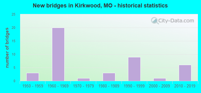
- New bridges - historical statistics
- 31950-1959
- 201960-1969
- 11970-1979
- 31980-1989
- 91990-1999
- 12000-2009
- 62010-2019

- Reconstructed bridges - Historical Statistics
- 11970-1979
- 41980-1989
- 11990-1999
- 02000-2009
- 12010-2019


- Bridge Condition - Deck
- 14.3%Very good
- 19.0%Good
- 57.1%Satisfactory
- 9.5%Fair

- Bridge Condition - Superstructure
- 4.8%Excellent
- 9.5%Very good
- 38.1%Good
- 42.9%Satisfactory
- 4.8%Fair

- Bridge Condition - Substructure
- 9.5%Excellent
- 9.5%Very good
- 57.1%Good
- 19.0%Satisfactory
- 4.8%Fair

- Bridge Condition - Channel
- 37.5%Satisfactory
- 62.5%Fair

- Bridge Condition - Culverts
- 50.0%Satisfactory
- 50.0%Fair
Find on map >> Show street view
Structure Number: 1415, Location: S 7 T 44 N R 6 E (Lat: 38.569694, Lng: -90.392389), Route carried "on" structure: Interstate 44, Year Built: 1967, Status: Open, Structure Length: 1.29m (4.23ft), Average Daily Traffic: 96,042 (year 2021), Truck Traffic: 12%, Average Future Daily Traffic: 120,053 (year 2041), Design Load: HS 20, Features Intersected: BR GRAVOIS CR
Minimum Vertical Clearance: 30+ m (98+ ft), Kilometerpoint: 448.654, Lanes on structure: 10, Base Highway Network: Yes, Owner: State Highway Agency, Approaching Roadway Width: 43.9m (144.0ft), Skew: 21 degrees, Material/Design: Concrete continuous, Design/Construction: Culvert, Number Of Spans In Main Unit: 3, Length of Maximum Span: 4.0m (13.1ft)
Condition: Channel: Satisfactory, Culverts: Satisfactory, Operating Rating: 87.3 metric tons, Method Used To Determine Operating Rating: Field evaluation and documented engineering judgment, Inventory Rating: 52.2 metric tons, Method Used To Determine Inventory Rating: Field evaluation and documented engineering judgment, Structural Evaluation: Equal to present minimum criteria, Waterway Adequacy: Equal to present desirable criteria, Approach Roadway Alignment: Equal to present desirable criteria, Designated Inspection Frequency: Every 24 months, Inspection Date: November 2021
Find on map >> Show street view
Structure Number: 15626, Location: S 4 T 44 N R 5 E (Lat: 38.578314, Lng: -90.466311), Route carried "on" structure: County highway , Year Built: 1993, Status: Posted for load, Structure Length: 5.21m (17.09ft), Average Daily Traffic: 26,967 (year 2020), Truck Traffic: 10%, Average Future Daily Traffic: 36,405 (year 2040), Design Load: HS 20+Mod, Features Intersected: GRAND GLAIZE CR, Facility Carried by Structure: DOUGHERTY FERRY RD
Minimum Vertical Clearance: 30+ m (98+ ft), Kilometerpoint: 10.139, Lanes on structure: 4, Owner: County Highway Agency, Approaching Roadway Width: 22.9m (75.1ft), Skew: 4 degrees, Material/Design: Prestressed concrete continuous, Design/Construction: Stringer/Multi-beam, Number Of Spans In Main Unit: 2, Length of Maximum Span: 25.6m (84.0ft), Curb-To-Curb Width: 24.4m (80.1ft), Out-to-Out Width: 25.4m (83.3ft)
Condition: Deck: Satisfactory, Superstructure: Good, Substructure: Good, Channel: Fair, Operating Rating: 89.1 metric tons, Method Used To Determine Operating Rating: Allowable Stress (AS), Inventory Rating: 65.7 metric tons, Method Used To Determine Inventory Rating: Allowable Stress (AS), Structural Evaluation: Better than present minimum criteria, Deck Geometry: Superior to present desirable criteria, Waterway Adequacy: Superior to present desirable criteria, Approach Roadway Alignment: Equal to present minimum criteria, Designated Inspection Frequency: Every 24 months, Inspection Date: March 2021, Deck Structure Type: Concrete Cast-file-Place, Wearing Surface/Protective System: Wearing Surface: Monolithic Concrete, Membrane: Epoxy, Deck Protection: Epoxy Coated Reinforcing
Find on map >> Show street view
Structure Number: 15645, Location: S 11 T 44 N R 5 E (Lat: 38.565550, Lng: -90.432331), Route carried "on" structure: County highway , Year Built: 1952, Year Reconstructed: 1981, Status: Posted for load, Structure Length: 5.58m (18.31ft), Average Daily Traffic: 5,030 (year 2020), Truck Traffic: 5%, Average Future Daily Traffic: 6,791 (year 2040), Design Load: HS 20, Features Intersected: BNSF RR, Facility Carried by Structure: MARSHALL RD
Minimum Vertical Clearance: 30+ m (98+ ft), Kilometerpoint: 0.000, Lanes on structure: 2, Owner: County Highway Agency, Approaching Roadway Width: 16.2m (53.1ft), Material/Design: Prestressed concrete continuous, Design/Construction: Stringer/Multi-beam, Number Of Spans In Main Unit: 4, Length of Maximum Span: 17.1m (56.1ft), Curb or Sidewalk Widths: Left: 1.8m (5.9ft), Right: 1.8m (5.9ft), Curb-To-Curb Width: 16.2m (53.1ft), Out-to-Out Width: 18.6m (61.0ft)
Condition: Deck: Good, Superstructure: Very good, Substructure: Good, Operating Rating: 49.5 metric tons, Method Used To Determine Operating Rating: Allowable Stress (AS), Inventory Rating: 27.9 metric tons, Method Used To Determine Inventory Rating: Allowable Stress (AS), Structural Evaluation: Better than present minimum criteria, Deck Geometry: Superior to present desirable criteria, Underclear: Superior to present desirable criteria, Approach Roadway Alignment: Equal to present desirable criteria, Designated Inspection Frequency: Every 24 months, Inspection Date: January 2022, Deck Structure Type: Concrete Cast-file-Place, Wearing Surface/Protective System: Wearing Surface: Monolithic Concrete, Membrane: Epoxy, Deck Protection: Epoxy Coated Reinforcing
Find on map >> Show street view
Structure Number: 19625, Location: S 10 T 44 N R 5 E (Lat: 38.572961, Lng: -90.447739), Route carried "on" structure: City street , Year Built: 1996, Status: Open, Structure Length: 2.19m (7.19ft), Average Daily Traffic: 800 (year 2020), Truck Traffic: 10%, Average Future Daily Traffic: 1,080 (year 2040), Design Load: HS 20, Features Intersected: UP RR, Facility Carried by Structure: HIGHLAND AVE
Minimum Vertical Clearance: 30+ m (98+ ft), Kilometerpoint: 0.161, Lanes on structure: 2, Owner: City or Municipal Highway Agency, Approaching Roadway Width: 6.1m (20.0ft), Material/Design: Prestressed concrete, Design/Construction: Stringer/Multi-beam, Number Of Spans In Main Unit: 1, Length of Maximum Span: 21.3m (69.9ft), Curb-To-Curb Width: 7.9m (25.9ft), Out-to-Out Width: 8.7m (28.5ft)
Condition: Deck: Good, Superstructure: Good, Substructure: Very good, Operating Rating: 65.7 metric tons, Method Used To Determine Operating Rating: Load Factor (LF), Inventory Rating: 32.4 metric tons, Method Used To Determine Inventory Rating: Load Factor (LF), Structural Evaluation: Better than present minimum criteria, Deck Geometry: Somewhat better than minimum adequacy, Approach Roadway Alignment: High priority of corrective action, Designated Inspection Frequency: Every 24 months, Inspection Date: January 2022, Deck Structure Type: Concrete Cast-file-Place
Find on map >> Show street view
Structure Number: 19629, Location: S 10 T 44 N R 5 E (Lat: 38.566292, Lng: -90.441622), Route carried "on" structure: City street , Year Built: 1993, Status: Open, Structure Length: 5.67m (18.60ft), Average Daily Traffic: 1,020 (year 2020), Truck Traffic: 1%, Average Future Daily Traffic: 1,377 (year 2040), Design Load: HS 20, Features Intersected: BNSF RR, Facility Carried by Structure: S GLENWOOD ST
Minimum Vertical Clearance: 30+ m (98+ ft), Kilometerpoint: 0.322, Lanes on structure: 2, Owner: City or Municipal Highway Agency, Approaching Roadway Width: 5.8m (19.0ft), Material/Design: Prestressed concrete, Design/Construction: Box Beam or Girders - Multiple, Number Of Spans In Main Unit: 3, Length of Maximum Span: 23.2m (76.1ft), Curb or Sidewalk Widths: Left: 1.7m (5.6ft), Right: 0.0m, Curb-To-Curb Width: 6.7m (22.0ft), Out-to-Out Width: 9.2m (30.2ft)
Condition: Deck: Satisfactory, Superstructure: Good, Substructure: Good, Operating Rating: 54.0 metric tons, Method Used To Determine Operating Rating: Allowable Stress (AS), Inventory Rating: 32.4 metric tons, Method Used To Determine Inventory Rating: Allowable Stress (AS), Structural Evaluation: Better than present minimum criteria, Deck Geometry: High priority of corrective action, Approach Roadway Alignment: Meets minimum limits, Length Of Structure Improvement: 0.67m (2.20ft), Designated Inspection Frequency: Every 24 months, Inspection Date: January 2022, Bridge Improvement Cost: $494,000, Roadway Improvement Cost: $49,000, Total Project Cost: $740,000 ( Estimate for 2022), Deck Structure Type: Concrete Cast-file-Place, Wearing Surface/Protective System: Wearing Surface: Integral Concrete, Deck Protection: Epoxy Coated Reinforcing
Find on map >> Show street view
Structure Number: 1963, Location: S 3 T 44 N R 5 E (Lat: 38.579822, Lng: -90.439261), Route carried "on" structure: City street , Year Built: 1995, Status: Open, Structure Length: 1.43m (4.69ft), Average Daily Traffic: 2,900 (year 2020), Truck Traffic: 2%, Average Future Daily Traffic: 3,915 (year 2040), Design Load: HS 20+Mod, Features Intersected: SUGAR CR, Facility Carried by Structure: BALLAS RD
Minimum Vertical Clearance: 30+ m (98+ ft), Kilometerpoint: 0.483, Lanes on structure: 2, Owner: City or Municipal Highway Agency, Approaching Roadway Width: 12.2m (40.0ft), Material/Design: Concrete, Design/Construction: Culvert, Number Of Spans In Main Unit: 3, Length of Maximum Span: 4.6m (15.1ft)
Condition: Channel: Fair, Culverts: Satisfactory, Operating Rating: 54.0 metric tons, Method Used To Determine Operating Rating: Load Factor (LF), Inventory Rating: 32.4 metric tons, Method Used To Determine Inventory Rating: Load Factor (LF), Structural Evaluation: Equal to present minimum criteria, Waterway Adequacy: Superior to present desirable criteria, Approach Roadway Alignment: Better than present minimum criteria, Designated Inspection Frequency: Every 24 months, Inspection Date: January 2022
Find on map >> Show street view
Structure Number: 19632, Location: S 3 T 44 N R 5 E (Lat: 38.576539, Lng: -90.434786), Route carried "on" structure: City street , Year Built: 1989, Status: Open, Structure Length: 2.32m (7.61ft), Average Daily Traffic: 2,900 (year 2020), Truck Traffic: 2%, Average Future Daily Traffic: 3,915 (year 2040), Design Load: HS 20, Features Intersected: UP RR, Facility Carried by Structure: BALLAS RD
Minimum Vertical Clearance: 30+ m (98+ ft), Kilometerpoint: 0.644, Lanes on structure: 2, Owner: City or Municipal Highway Agency, Approaching Roadway Width: 9.1m (29.9ft), Material/Design: Steel, Design/Construction: Stringer/Multi-beam, Number Of Spans In Main Unit: 1, Length of Maximum Span: 21.3m (69.9ft), Curb or Sidewalk Widths: Left: 0.0m, Right: 1.5m (4.9ft), Curb-To-Curb Width: 9.1m (29.9ft), Out-to-Out Width: 11.5m (37.7ft)
Condition: Deck: Satisfactory, Superstructure: Satisfactory, Substructure: Satisfactory, Operating Rating: 62.1 metric tons, Method Used To Determine Operating Rating: Allowable Stress (AS), Inventory Rating: 36.0 metric tons, Method Used To Determine Inventory Rating: Allowable Stress (AS), Structural Evaluation: Equal to present minimum criteria, Deck Geometry: Meets minimum limits, Approach Roadway Alignment: Equal to present desirable criteria, Designated Inspection Frequency: Every 24 months, Inspection Date: January 2022, Deck Structure Type: Concrete Cast-file-Place, Wearing Surface/Protective System: Wearing Surface: Monolithic Concrete, Membrane: Epoxy, Deck Protection: Epoxy Coated Reinforcing
Find on map >> Show street view
Structure Number: 19633, Location: S 2 T 44 N R 5 E (Lat: 38.582350, Lng: -90.425022), Route carried "on" structure: City street , Year Built: 1965, Status: Posted for load, Structure Length: 1.31m (4.30ft), Average Daily Traffic: 2,845 (year 2020), Truck Traffic: 2%, Average Future Daily Traffic: 3,841 (year 2040), Features Intersected: SUGAR CR, Facility Carried by Structure: COUCH AVE
Minimum Vertical Clearance: 30+ m (98+ ft), Kilometerpoint: 0.805, Lanes on structure: 2, Owner: City or Municipal Highway Agency, Approaching Roadway Width: 8.2m (26.9ft), Material/Design: Concrete continuous, Design/Construction: Culvert, Number Of Spans In Main Unit: 3, Length of Maximum Span: 3.7m (12.1ft), Curb-To-Curb Width: 8.2m (26.9ft), Out-to-Out Width: 13.7m (44.9ft)
Condition: Channel: Fair, Culverts: Fair, Operating Rating: 75.6 metric tons, Method Used To Determine Operating Rating: Allowable Stress (AS), Inventory Rating: 23.4 metric tons, Method Used To Determine Inventory Rating: Allowable Stress (AS), Structural Evaluation: Somewhat better than minimum adequacy, Deck Geometry: High priority of corrective action, Waterway Adequacy: Superior to present desirable criteria, Approach Roadway Alignment: Somewhat better than minimum adequacy, Length Of Structure Improvement: 0.20m (0.66ft), Designated Inspection Frequency: Every 24 months, Inspection Date: January 2022, Bridge Improvement Cost: $85,000, Roadway Improvement Cost: $9,000, Total Project Cost: $128,000 ( Estimate for 2022), Deck Structure Type: Concrete Cast-file-Place, Wearing Surface/Protective System: Wearing Surface: Bituminous
Find on map >> Show street view
Structure Number: 19636, Location: S 2 T 44 N R 5 E (Lat: 38.579436, Lng: -90.424917), Route carried "on" structure: City street , Year Built: 1986, Status: Posted for load, Structure Length: 3.57m (11.71ft), Average Daily Traffic: 2,845 (year 2020), Truck Traffic: 2%, Average Future Daily Traffic: 3,841 (year 2040), Design Load: H 20, Features Intersected: UP RR, Facility Carried by Structure: COUCH AVE
Minimum Vertical Clearance: 30+ m (98+ ft), Kilometerpoint: 0.966, Lanes on structure: 2, Owner: City or Municipal Highway Agency, Approaching Roadway Width: 7.9m (25.9ft), Material/Design: Steel, Design/Construction: Stringer/Multi-beam, Number Of Spans In Main Unit: 3, Length of Maximum Span: 13.4m (44.0ft), Curb or Sidewalk Widths: Left: 1.3m (4.3ft), Right: 0.0m, Curb-To-Curb Width: 7.9m (25.9ft), Out-to-Out Width: 10.2m (33.5ft)
Condition: Deck: Satisfactory, Superstructure: Good, Substructure: Good, Operating Rating: 43.2 metric tons, Method Used To Determine Operating Rating: Allowable Stress (AS), Inventory Rating: 22.5 metric tons, Method Used To Determine Inventory Rating: Allowable Stress (AS), Structural Evaluation: Equal to present minimum criteria, Deck Geometry: High priority of corrective action, Underclear: Meets minimum limits, Approach Roadway Alignment: Somewhat better than minimum adequacy, Length Of Structure Improvement: 0.45m (1.48ft), Designated Inspection Frequency: Every 24 months, Inspection Date: January 2022, Bridge Improvement Cost: $386,000, Roadway Improvement Cost: $39,000, Total Project Cost: $580,000 ( Estimate for 2022), Deck Structure Type: Concrete Cast-file-Place, Wearing Surface/Protective System: Wearing Surface: Monolithic Concrete, Membrane: Other, Deck Protection: Epoxy Coated Reinforcing
Find on map >> Show street view
Structure Number: 1964, Location: S 11 T 44 N R 5 E (Lat: 38.565117, Lng: -90.422158), Route carried "on" structure: City street , Year Built: 1994, Status: Open, Structure Length: 7.65m (25.10ft), Average Daily Traffic: 1,450 (year 2020), Truck Traffic: 1%, Average Future Daily Traffic: 1,958 (year 2040), Design Load: HS 20, Features Intersected: BNSF RR, Facility Carried by Structure: FOREST AVE
Minimum Vertical Clearance: 30+ m (98+ ft), Kilometerpoint: 1.127, Lanes on structure: 2, Owner: City or Municipal Highway Agency, Approaching Roadway Width: 7.3m (24.0ft), Material/Design: Prestressed concrete, Design/Construction: Tee Beam, Number Of Spans In Main Unit: 5, Length of Maximum Span: 15.2m (49.9ft), Curb or Sidewalk Widths: Left: 1.2m (3.9ft), Right: 0.0m, Curb-To-Curb Width: 7.9m (25.9ft), Out-to-Out Width: 10.1m (33.1ft)
Condition: Deck: Good, Superstructure: Satisfactory, Substructure: Good, Operating Rating: 54.0 metric tons, Method Used To Determine Operating Rating: Allowable Stress (AS), Inventory Rating: 32.4 metric tons, Method Used To Determine Inventory Rating: Allowable Stress (AS), Structural Evaluation: Equal to present minimum criteria, Deck Geometry: Meets minimum limits, Underclear: Equal to present minimum criteria, Approach Roadway Alignment: Equal to present minimum criteria, Designated Inspection Frequency: Every 24 months, Inspection Date: January 2022, Deck Structure Type: Concrete Cast-file-Place, Wearing Surface/Protective System: Wearing Surface: Monolithic Concrete, Deck Protection: Epoxy Coated Reinforcing
Find on map >> Show street view
Structure Number: 19641, Location: S 1 T 44 N R 5 E (Lat: 38.579511, Lng: -90.410997), Route carried "on" structure: City street , Year Built: 1986, Status: Posted for load, Structure Length: 4.33m (14.21ft), Average Daily Traffic: 3,450 (year 2020), Truck Traffic: 1%, Average Future Daily Traffic: 4,658 (year 2040), Design Load: HS 20, Features Intersected: UP RR, Facility Carried by Structure: HARRISON AVE
Minimum Vertical Clearance: 30+ m (98+ ft), Kilometerpoint: 1.287, Lanes on structure: 2, Owner: City or Municipal Highway Agency, Approaching Roadway Width: 9.1m (29.9ft), Material/Design: Steel, Design/Construction: Stringer/Multi-beam, Number Of Spans In Main Unit: 3, Length of Maximum Span: 19.8m (65.0ft), Curb or Sidewalk Widths: Left: 1.5m (4.9ft), Right: 0.0m, Curb-To-Curb Width: 9.1m (29.9ft), Out-to-Out Width: 11.5m (37.7ft)
Condition: Deck: Fair, Superstructure: Good, Substructure: Good, Operating Rating: 45.0 metric tons, Method Used To Determine Operating Rating: Allowable Stress (AS), Inventory Rating: 32.4 metric tons, Method Used To Determine Inventory Rating: Allowable Stress (AS), Structural Evaluation: Better than present minimum criteria, Deck Geometry: Meets minimum limits, Underclear: Equal to present minimum criteria, Approach Roadway Alignment: Equal to present minimum criteria, Designated Inspection Frequency: Every 24 months, Inspection Date: January 2022, Deck Structure Type: Concrete Cast-file-Place, Wearing Surface/Protective System: Wearing Surface: Monolithic Concrete, Membrane: Epoxy, Deck Protection: Epoxy Coated Reinforcing
Find on map >> Show street view
Structure Number: 19645, Location: S 1 T 44 N R 5 E (Lat: 38.580533, Lng: -90.408711), Route carried "on" structure: City street , Year Built: 1999, Status: Open, Structure Length: 2.87m (9.42ft), Average Daily Traffic: 5,950 (year 2020), Truck Traffic: 2%, Average Future Daily Traffic: 8,033 (year 2040), Design Load: HS 20, Features Intersected: UP RR, Facility Carried by Structure: CLAY AVE
Minimum Vertical Clearance: 30+ m (98+ ft), Kilometerpoint: 1.448, Lanes on structure: 2, Owner: City or Municipal Highway Agency, Approaching Roadway Width: 7.3m (24.0ft), Material/Design: Steel, Design/Construction: Truss - Thru, Number Of Spans In Main Unit: 1, Length of Maximum Span: 27.4m (89.9ft), Curb or Sidewalk Widths: Left: 1.7m (5.6ft), Right: 1.7m (5.6ft), Curb-To-Curb Width: 7.3m (24.0ft), Out-to-Out Width: 8.1m (26.6ft)
Condition: Deck: Satisfactory, Superstructure: Good, Substructure: Very good, Operating Rating: 54.9 metric tons, Method Used To Determine Operating Rating: Load Factor (LF), Inventory Rating: 32.4 metric tons, Method Used To Determine Inventory Rating: Load Factor (LF), Structural Evaluation: Better than present minimum criteria, Deck Geometry: High priority of replacement, Underclear: Better than present minimum criteria, Approach Roadway Alignment: Meets minimum limits, Length Of Structure Improvement: 0.38m (1.25ft), Designated Inspection Frequency: Every 24 months, Critical Feature Inspection Frequency: Every 24 months, Inspection Date: January 2022, Critical Feature Inspection Date: January 2022, Bridge Improvement Cost: $326,000, Roadway Improvement Cost: $33,000, Total Project Cost: $490,000 ( Estimate for 2022), Deck Structure Type: Concrete Cast-file-Place, Wearing Surface/Protective System: Wearing Surface: Monolithic Concrete, Deck Protection: Epoxy Coated Reinforcing
Find on map >> Show street view
Structure Number: 2649, Location: S 34 T 44 N R 6 E (Lat: 38.513531, Lng: -90.340775), Route carried "on" structure: US 50, Year Built: 1977, Status: Open, Structure Length: 5.06m (16.60ft), Average Daily Traffic: 43,006 (year 2021), Truck Traffic: 6%, Average Future Daily Traffic: 60,208 (year 2041), Design Load: HS 20, Features Intersected: BNSF RR
Minimum Vertical Clearance: 30+ m (98+ ft), Kilometerpoint: 414.840, Lanes on structure: 5, Base Highway Network: Yes, Owner: State Highway Agency, Approaching Roadway Width: 14.6m (47.9ft), Skew: 22 degrees, Material/Design: Prestressed concrete continuous, Design/Construction: Stringer/Multi-beam, Number Of Spans In Main Unit: 3, Length of Maximum Span: 17.0m (55.8ft), Curb or Sidewalk Widths: Left: 0.2m (0.7ft), Right: 0.2m (0.7ft), Curb-To-Curb Width: 25.9m (85.0ft), Out-to-Out Width: 26.9m (88.3ft)
Condition: Deck: Satisfactory, Superstructure: Satisfactory, Substructure: Satisfactory, Operating Rating: 75.6 metric tons, Method Used To Determine Operating Rating: Load Factor (LF), Inventory Rating: 36.9 metric tons, Method Used To Determine Inventory Rating: Load Factor (LF), Structural Evaluation: Equal to present minimum criteria, Deck Geometry: Superior to present desirable criteria, Underclear: Superior to present desirable criteria, Approach Roadway Alignment: Equal to present desirable criteria, Designated Inspection Frequency: Every 24 months, Inspection Date: July 2020, Deck Structure Type: Concrete Cast-file-Place, Wearing Surface/Protective System: Wearing Surface: Latex Concrete, Membrane: Built-up
Find on map >> Show street view
Structure Number: 28518, Location: S 4 T 44 N R 5 E (Lat: 38.569411, Lng: -90.475344), Route carried "on" structure: County highway , Year Built: 2000, Status: Posted for load, Structure Length: 0.76m (2.49ft), Average Daily Traffic: 23,339 (year 2020), Truck Traffic: 10%, Average Future Daily Traffic: 31,508 (year 2040), Design Load: HS 20, Features Intersected: BR OF GRAND GLAIZE, Facility Carried by Structure: DOUGHERTY FERRY RD
Minimum Vertical Clearance: 30+ m (98+ ft), Kilometerpoint: 0.483, Lanes on structure: 5, Owner: County Highway Agency, Approaching Roadway Width: 18.9m (62.0ft), Skew: 1 degrees, Material/Design: Concrete continuous, Design/Construction: Culvert, Number Of Spans In Main Unit: 2, Length of Maximum Span: 3.7m (12.1ft)
Condition: Channel: Fair, Culverts: Satisfactory, Operating Rating: 89.1 metric tons, Method Used To Determine Operating Rating: Load Factor (LF), Inventory Rating: 67.5 metric tons, Method Used To Determine Inventory Rating: Load Factor (LF), Structural Evaluation: Equal to present minimum criteria, Waterway Adequacy: Equal to present desirable criteria, Approach Roadway Alignment: Equal to present desirable criteria, Designated Inspection Frequency: Every 24 months, Inspection Date: March 2020
Find on map >> Show street view
Structure Number: 3136, Location: S 6 T 44 N R 6 E (Lat: 38.585306, Lng: -90.393944), Route carried "on" structure: City street 228, Year Built: 1950, Status: Open, Structure Length: 0.85m (2.79ft), Average Daily Traffic: 500 (year 2020), Truck Traffic: 1%, Average Future Daily Traffic: 675 (year 2040), Design Load: HS 20, Features Intersected: CREEK, Facility Carried by Structure: DICKSON AVE
Minimum Vertical Clearance: 30+ m (98+ ft), Kilometerpoint: 0.000, Lanes on structure: 2, Owner: City or Municipal Highway Agency, Approaching Roadway Width: 7.2m (23.6ft), Skew: 2 degrees, Material/Design: Concrete, Design/Construction: Tee Beam, Number Of Spans In Main Unit: 1, Length of Maximum Span: 8.5m (27.9ft), Curb-To-Curb Width: 7.2m (23.6ft), Out-to-Out Width: 11.6m (38.1ft)
Condition: Deck: Fair, Superstructure: Fair, Substructure: Fair, Channel: Satisfactory, Operating Rating: 32.4 metric tons, Method Used To Determine Operating Rating: Load Factor (LF), Inventory Rating: 19.8 metric tons, Method Used To Determine Inventory Rating: Load Factor (LF), Structural Evaluation: Somewhat better than minimum adequacy, Deck Geometry: Meets minimum limits, Waterway Adequacy: Equal to present minimum criteria, Approach Roadway Alignment: Equal to present desirable criteria, Designated Inspection Frequency: Every 24 months, Inspection Date: January 2022, Deck Structure Type: Concrete Cast-file-Place, Wearing Surface/Protective System: Wearing Surface: Bituminous
Find on map >> Show street view
Structure Number: 31361, Location: S 6 T 44 N R 6 E (Lat: 38.584417, Lng: -90.392900), Route carried "on" structure: City street , Year Built: 1950, Status: Open, Structure Length: 1.07m (3.51ft), Average Daily Traffic: 200 (year 2020), Truck Traffic: 1%, Average Future Daily Traffic: 270 (year 2040), Design Load: HS 20, Features Intersected: CREEK, Facility Carried by Structure: PARKWOODS AVE
Minimum Vertical Clearance: 30+ m (98+ ft), Kilometerpoint: 0.000, Lanes on structure: 2, Owner: City or Municipal Highway Agency, Approaching Roadway Width: 6.4m (21.0ft), Skew: 4 degrees, Material/Design: Concrete continuous, Design/Construction: Culvert, Number Of Spans In Main Unit: 3, Length of Maximum Span: 4.0m (13.1ft)
Condition: Channel: Satisfactory, Culverts: Fair, Operating Rating: 32.4 metric tons, Method Used To Determine Operating Rating: Field evaluation and documented engineering judgment, Inventory Rating: 19.8 metric tons, Method Used To Determine Inventory Rating: Field evaluation and documented engineering judgment, Structural Evaluation: Somewhat better than minimum adequacy, Waterway Adequacy: Equal to present minimum criteria, Approach Roadway Alignment: Equal to present desirable criteria, Designated Inspection Frequency: Every 24 months, Inspection Date: January 2022
Find on map >> Show street view
Structure Number: 35838, Location: S 14 T 44 N R 5 E (Lat: 38.551631, Lng: -90.422169), Route carried "on" structure: State highway 366, Year Built: 2018, Status: Open, Structure Length: 4.52m (14.83ft), Average Daily Traffic: 14,341 (year 2021), Truck Traffic: 13%, Average Future Daily Traffic: 20,077 (year 2041), Features Intersected: RP IS270E TO IS44E
Minimum Vertical Clearance: 30+ m (98+ ft), Kilometerpoint: 0.782, Lanes on structure: 1, Lanes under structure: 1, Base Highway Network: Yes, Owner: State Highway Agency, Approaching Roadway Width: 7.3m (24.0ft), Skew: 9 degrees, Material/Design: Prestressed concrete, Design/Construction: Tee Beam, Number Of Spans In Main Unit: 1, Length of Maximum Span: 41.9m (137.5ft), Curb-To-Curb Width: 7.3m (24.0ft), Out-to-Out Width: 9.3m (30.5ft)
Condition: Deck: Very good, Superstructure: Excellent, Substructure: Excellent, Operating Rating: 62.1 metric tons, Method Used To Determine Operating Rating: Load Factor (LF), Inventory Rating: 36.0 metric tons, Method Used To Determine Inventory Rating: Load Factor (LF), Structural Evaluation: Superior to present desirable criteria, Deck Geometry: High priority of replacement, Approach Roadway Alignment: Equal to present desirable criteria, Designated Inspection Frequency: Every 24 months, Inspection Date: December 2020, Deck Structure Type: Concrete Cast-file-Place, Wearing Surface/Protective System: Wearing Surface: Monolithic Concrete, Deck Protection: Epoxy Coated Reinforcing
Find on map >> Show street view
Structure Number: 35858, Location: S 14 T 44 N R 5 E (Lat: 38.553681, Lng: -90.419333), Route carried "on" structure: State highway 366, Year Built: 2018, Status: Open, Structure Length: 9.21m (30.22ft), Average Daily Traffic: 13,846 (year 2021), Truck Traffic: 4%, Average Future Daily Traffic: 19,384 (year 2041), Features Intersected: IS 44, RP IS270E TO IS44
Minimum Vertical Clearance: 30+ m (98+ ft), Kilometerpoint: 18.160, Lanes on structure: 2, Lanes under structure: 8, Base Highway Network: Yes, Owner: State Highway Agency, Approaching Roadway Width: 10.4m (34.1ft), Skew: 4 degrees, Material/Design: Steel continuous, Design/Construction: Stringer/Multi-beam, Number Of Spans In Main Unit: 2, Length of Maximum Span: 49.5m (162.4ft), Curb-To-Curb Width: 9.8m (32.2ft), Out-to-Out Width: 10.6m (34.8ft)
Condition: Deck: Very good, Superstructure: Very good, Substructure: Excellent, Operating Rating: 84.6 metric tons, Method Used To Determine Operating Rating: Load Factor (LF), Inventory Rating: 50.4 metric tons, Method Used To Determine Inventory Rating: Load Factor (LF), Structural Evaluation: Equal to present desirable criteria, Deck Geometry: Meets minimum limits, Underclear: Meets minimum limits, Approach Roadway Alignment: Equal to present minimum criteria, Designated Inspection Frequency: Every 24 months, Inspection Date: June 2020, Deck Structure Type: Concrete Cast-file-Place, Wearing Surface/Protective System: Wearing Surface: Monolithic Concrete, Deck Protection: Epoxy Coated Reinforcing
Find on map >> Show street view
Structure Number: 4264, Location: S 14 T 44 N R 5 E (Lat: 38.551689, Lng: -90.429806), Route carried "on" structure: ServiceState highway 44, Year Built: 1996, Status: Open, Structure Length: 9.51m (31.20ft), Average Daily Traffic: 637 (year 2021), Truck Traffic: 2%, Average Future Daily Traffic: 956 (year 2041), Design Load: HS 20+Mod, Features Intersected: IS 270, RP IS44E TO IS27
Minimum Vertical Clearance: 30+ m (98+ ft), Kilometerpoint: 0.013, Lanes on structure: 2, Lanes under structure: 11, Owner: State Highway Agency, Approaching Roadway Width: 6.1m (20.0ft), Material/Design: Steel continuous, Design/Construction: Stringer/Multi-beam, Number Of Spans In Main Unit: 5, Length of Maximum Span: 27.4m (89.9ft), Curb or Sidewalk Widths: Left: 1.7m (5.6ft), Right: 0.2m (0.7ft), Curb-To-Curb Width: 10.0m (32.8ft), Out-to-Out Width: 10.8m (35.4ft)
Condition: Deck: Satisfactory, Superstructure: Good, Substructure: Good, Operating Rating: 85.5 metric tons, Method Used To Determine Operating Rating: Load Factor (LF), Inventory Rating: 51.3 metric tons, Method Used To Determine Inventory Rating: Load Factor (LF), Structural Evaluation: Better than present minimum criteria, Deck Geometry: Equal to present minimum criteria, Underclear: High priority of corrective action, Approach Roadway Alignment: Equal to present desirable criteria, Designated Inspection Frequency: Every 24 months, Inspection Date: June 2020, Deck Structure Type: Concrete Cast-file-Place, Wearing Surface/Protective System: Wearing Surface: Epoxy Overlay, Deck Protection: Epoxy Coated Reinforcing
Find on map >> Show street view
Structure Number: 713, Location: S 10 T 44 N R 5 E (Lat: 38.567236, Lng: -90.440019), Route carried "on" structure: County highway , Year Built: 1962, Year Reconstructed: 2017, Status: Open, Structure Length: 7.80m (25.59ft), Average Daily Traffic: 9,090 (year 2021), Truck Traffic: 4%, Average Future Daily Traffic: 12,726 (year 2041), Design Load: H 20, Features Intersected: IS 270, Facility Carried by Structure: BIG BEND RD E
Minimum Vertical Clearance: 30+ m (98+ ft), Kilometerpoint: 10.334, Lanes on structure: 5, Lanes under structure: 10, Owner: State Highway Agency, Approaching Roadway Width: 19.5m (64.0ft), Skew: 20 degrees, Material/Design: Steel continuous, Design/Construction: Stringer/Multi-beam, Number Of Spans In Main Unit: 4, Length of Maximum Span: 21.3m (69.9ft), Curb or Sidewalk Widths: Left: 1.8m (5.9ft), Right: 1.8m (5.9ft), Curb-To-Curb Width: 19.5m (64.0ft), Out-to-Out Width: 24.6m (80.7ft)
Condition: Deck: Very good, Superstructure: Satisfactory, Substructure: Good, Operating Rating: 56.7 metric tons, Method Used To Determine Operating Rating: Load Factor (LF), Inventory Rating: 34.2 metric tons, Method Used To Determine Inventory Rating: Load Factor (LF), Structural Evaluation: Equal to present minimum criteria, Deck Geometry: Meets minimum limits, Underclear: Equal to present minimum criteria, Approach Roadway Alignment: Equal to present desirable criteria, Designated Inspection Frequency: Every 24 months, Inspection Date: June 2020, Deck Structure Type: Concrete Cast-file-Place, Wearing Surface/Protective System: Wearing Surface: Monolithic Concrete, Deck Protection: Epoxy Coated Reinforcing
Find on map >> Show street view
Structure Number: 715, Location: S 10 T 44 N R 5 E (Lat: 38.562667, Lng: -90.439278), Route carried "on" structure: Interstate 270, Year Built: 1962, Year Reconstructed: 1985, Status: Posted for load, Structure Length: 5.30m (17.39ft), Average Daily Traffic: 80,882 (year 2021), Truck Traffic: 18%, Average Future Daily Traffic: 101,103 (year 2041), Design Load: HS 20+Mod, Features Intersected: CRD MARSHALL RD
Minimum Vertical Clearance: 30+ m (98+ ft), Kilometerpoint: 11.731, Lanes on structure: 5, Lanes under structure: 2, Base Highway Network: Yes, Owner: State Highway Agency, Approaching Roadway Width: 15.8m (51.8ft), Material/Design: Concrete continuous, Design/Construction: Slab, Number Of Spans In Main Unit: 3, Length of Maximum Span: 22.9m (75.1ft), Curb or Sidewalk Widths: Left: 0.2m (0.7ft), Right: 0.2m (0.7ft), Curb-To-Curb Width: 18.8m (61.7ft), Out-to-Out Width: 19.6m (64.3ft)
Condition: Deck: Satisfactory, Superstructure: Satisfactory, Substructure: Satisfactory, Operating Rating: 52.2 metric tons, Method Used To Determine Operating Rating: Load Factor (LF), Inventory Rating: 31.5 metric tons, Method Used To Determine Inventory Rating: Load Factor (LF), Structural Evaluation: Equal to present minimum criteria, Deck Geometry: High priority of replacement, Underclear: Meets minimum limits, Approach Roadway Alignment: Equal to present desirable criteria, Designated Inspection Frequency: Every 24 months, Inspection Date: June 2020, Deck Structure Type: Concrete Cast-file-Place, Wearing Surface/Protective System: Wearing Surface: Bituminous, Membrane: Built-up
Find on map >> Show street view
Structure Number: 716, Location: S 10 T 44 N R 5 E (Lat: 38.562597, Lng: -90.439483), Route carried "on" structure: Interstate 270, Year Built: 1962, Year Reconstructed: 1985, Status: Posted for load, Structure Length: 5.30m (17.39ft), Average Daily Traffic: 78,747 (year 2021), Truck Traffic: 18%, Average Future Daily Traffic: 98,434 (year 2041), Design Load: HS 20+Mod, Features Intersected: CRD MARSHALL RD
Minimum Vertical Clearance: 30+ m (98+ ft), Kilometerpoint: 45.800, Lanes on structure: 5, Lanes under structure: 2, Base Highway Network: Yes, Owner: State Highway Agency, Approaching Roadway Width: 15.8m (51.8ft), Material/Design: Concrete continuous, Design/Construction: Slab, Number Of Spans In Main Unit: 3, Length of Maximum Span: 22.9m (75.1ft), Curb or Sidewalk Widths: Left: 0.2m (0.7ft), Right: 0.2m (0.7ft), Curb-To-Curb Width: 18.8m (61.7ft), Out-to-Out Width: 19.6m (64.3ft)
Condition: Deck: Good, Superstructure: Good, Substructure: Satisfactory, Operating Rating: 52.2 metric tons, Method Used To Determine Operating Rating: Load Factor (LF), Inventory Rating: 31.5 metric tons, Method Used To Determine Inventory Rating: Load Factor (LF), Structural Evaluation: Equal to present minimum criteria, Deck Geometry: High priority of replacement, Underclear: Meets minimum limits, Approach Roadway Alignment: Equal to present desirable criteria, Designated Inspection Frequency: Every 24 months, Inspection Date: June 2020, Deck Structure Type: Concrete Cast-file-Place, Wearing Surface/Protective System: Wearing Surface: Bituminous, Membrane: Built-up
Find on map >> Show street view
Structure Number: 806, Location: S 3 T 44 N R 5 E (Lat: 38.579497, Lng: -90.446994), Route carried "on" structure: Interstate 270, Year Built: 1962, Status: Open, Structure Length: 1.44m (4.72ft), Average Daily Traffic: 193,903 (year 2021), Truck Traffic: 18%, Average Future Daily Traffic: 242,379 (year 2041), Design Load: HS 20, Features Intersected: SUGAR CR
Minimum Vertical Clearance: 30+ m (98+ ft), Kilometerpoint: 13.737, Lanes on structure: 11, Base Highway Network: Yes, Owner: State Highway Agency, Approaching Roadway Width: 14.6m (47.9ft), Skew: 20 degrees, Material/Design: Concrete continuous, Design/Construction: Culvert, Number Of Spans In Main Unit: 3, Length of Maximum Span: 4.6m (15.1ft)
Condition: Channel: Fair, Culverts: Fair, Operating Rating: 72.0 metric tons, Method Used To Determine Operating Rating: Field evaluation and documented engineering judgment, Inventory Rating: 43.2 metric tons, Method Used To Determine Inventory Rating: Field evaluation and documented engineering judgment, Structural Evaluation: Somewhat better than minimum adequacy, Waterway Adequacy: Equal to present desirable criteria, Approach Roadway Alignment: Equal to present desirable criteria, Designated Inspection Frequency: Every 24 months, Inspection Date: November 2021
Find on map >> Show street view
Structure Number: 81, Location: S 31 T 49 N R 24 W (Lat: 38.994083, Lng: -93.594133), Route carried "on" structure: County highway , Year Built: 1963, Status: Open, Structure Length: 6.19m (20.31ft), Average Daily Traffic: 68 (year 2021), Truck Traffic: 9%, Average Future Daily Traffic: 99 (year 2041), Design Load: H 15, Features Intersected: IS 70, Facility Carried by Structure: WALKENHORST RD S
Minimum Vertical Clearance: 30+ m (98+ ft), Kilometerpoint: 1.223, Lanes on structure: 2, Lanes under structure: 4, Owner: State Highway Agency, Approaching Roadway Width: 5.5m (18.0ft), Material/Design: Concrete continuous, Design/Construction: Slab, Number Of Spans In Main Unit: 4, Length of Maximum Span: 17.1m (56.1ft), Curb-To-Curb Width: 7.3m (24.0ft), Out-to-Out Width: 8.4m (27.6ft)
Condition: Deck: Satisfactory, Superstructure: Satisfactory, Substructure: Good, Operating Rating: 35.1 metric tons, Method Used To Determine Operating Rating: Load Factor (LF), Inventory Rating: 20.7 metric tons, Method Used To Determine Inventory Rating: Load Factor (LF), Structural Evaluation: Equal to present minimum criteria, Deck Geometry: Equal to present minimum criteria, Underclear: Meets minimum limits, Approach Roadway Alignment: Equal to present desirable criteria, Designated Inspection Frequency: Every 24 months, Inspection Date: January 2021, Deck Structure Type: Concrete Cast-file-Place, Wearing Surface/Protective System: Wearing Surface: Bituminous
Find on map >> Show street view
Structure Number: 81, Location: S 14 T 44 N R 5 E (Lat: 38.548533, Lng: -90.426975), Route carried "on" structure: Interstate 270, Year Built: 1962, Year Reconstructed: 1996, Status: Posted for load, Structure Length: 11.31m (37.11ft), Average Daily Traffic: 172,495 (year 2021), Truck Traffic: 12%, Average Future Daily Traffic: 215,619 (year 2041), Design Load: HS 20+Mod, Features Intersected: IS 44, RP IS270E TO IS44
Minimum Vertical Clearance: 30+ m (98+ ft), Kilometerpoint: 9.791, Lanes on structure: 10, Lanes under structure: 9, Base Highway Network: Yes, Owner: State Highway Agency, Approaching Roadway Width: 53.6m (175.9ft), Skew: 21 degrees, Material/Design: Prestressed concrete continuous, Design/Construction: Stringer/Multi-beam, Number Of Spans In Main Unit: 6, Length of Maximum Span: 22.9m (75.1ft), Curb-To-Curb Width: 43.3m (142.1ft), Out-to-Out Width: 44.9m (147.3ft)
Condition: Deck: Satisfactory, Superstructure: Satisfactory, Substructure: Good, Operating Rating: 52.2 metric tons, Method Used To Determine Operating Rating: Load Factor (LF), Inventory Rating: 31.5 metric tons, Method Used To Determine Inventory Rating: Load Factor (LF), Structural Evaluation: Equal to present minimum criteria, Deck Geometry: Better than present minimum criteria, Underclear: High priority of corrective action, Approach Roadway Alignment: Equal to present desirable criteria, Length Of Structure Improvement: 1.22m (4.00ft), Designated Inspection Frequency: Every 24 months, Inspection Date: June 2020, Bridge Improvement Cost: $3,754,000, Roadway Improvement Cost: $375,000, Total Project Cost: $5,630,000 ( Estimate for 2022), Deck Structure Type: Concrete Cast-file-Place, Wearing Surface/Protective System: Wearing Surface: Other, Membrane: Built-up
Find on map >> Show street view
Structure Number: 825, Location: S 23 T 44 N R 5 E (Lat: 38.542039, Lng: -90.420256), Route carried "on" structure: Interstate 270, Year Built: 1967, Year Reconstructed: 1992, Status: Open, Structure Length: 4.39m (14.40ft), Average Daily Traffic: 93,748 (year 2021), Truck Traffic: 12%, Average Future Daily Traffic: 117,185 (year 2041), Design Load: HS 20, Features Intersected: CST ROTT RD
Minimum Vertical Clearance: 30+ m (98+ ft), Kilometerpoint: 8.895, Lanes on structure: 6, Lanes under structure: 2, Base Highway Network: Yes, Owner: State Highway Agency, Approaching Roadway Width: 15.8m (51.8ft), Skew: 10 degrees, Material/Design: Concrete continuous, Design/Construction: Slab, Number Of Spans In Main Unit: 3, Length of Maximum Span: 16.8m (55.1ft), Curb-To-Curb Width: 25.0m (82.0ft), Out-to-Out Width: 25.8m (84.6ft)
Condition: Deck: Satisfactory, Superstructure: Satisfactory, Substructure: Good, Operating Rating: 57.6 metric tons, Method Used To Determine Operating Rating: Load Factor (LF), Inventory Rating: 34.2 metric tons, Method Used To Determine Inventory Rating: Load Factor (LF), Structural Evaluation: Equal to present minimum criteria, Deck Geometry: Meets minimum limits, Underclear: Meets minimum limits, Approach Roadway Alignment: Equal to present minimum criteria, Designated Inspection Frequency: Every 24 months, Inspection Date: June 2020, Deck Structure Type: Concrete Cast-file-Place, Wearing Surface/Protective System: Wearing Surface: Other, Membrane: Built-up
Find on map >> Show street view
Structure Number: 826, Location: S 23 T 44 N R 5 E (Lat: 38.541850, Lng: -90.420456), Route carried "on" structure: Interstate 270, Year Built: 1967, Year Reconstructed: 1992, Status: Open, Structure Length: 4.39m (14.40ft), Average Daily Traffic: 75,641 (year 2021), Truck Traffic: 12%, Average Future Daily Traffic: 94,551 (year 2041), Design Load: HS 20, Features Intersected: CST ROTT RD
Minimum Vertical Clearance: 30+ m (98+ ft), Kilometerpoint: 48.655, Lanes on structure: 6, Lanes under structure: 2, Base Highway Network: Yes, Owner: State Highway Agency, Approaching Roadway Width: 15.8m (51.8ft), Skew: 10 degrees, Material/Design: Concrete continuous, Design/Construction: Slab, Number Of Spans In Main Unit: 3, Length of Maximum Span: 16.8m (55.1ft), Curb-To-Curb Width: 25.0m (82.0ft), Out-to-Out Width: 25.8m (84.6ft)
Condition: Deck: Satisfactory, Superstructure: Satisfactory, Substructure: Good, Operating Rating: 57.6 metric tons, Method Used To Determine Operating Rating: Load Factor (LF), Inventory Rating: 34.2 metric tons, Method Used To Determine Inventory Rating: Load Factor (LF), Structural Evaluation: Equal to present minimum criteria, Deck Geometry: Meets minimum limits, Underclear: Meets minimum limits, Approach Roadway Alignment: Equal to present minimum criteria, Designated Inspection Frequency: Every 24 months, Inspection Date: June 2020, Deck Structure Type: Concrete Cast-file-Place, Wearing Surface/Protective System: Wearing Surface: Other
Find on map >> Show street view
Structure Number: 35838, Location: S 14 T 44 N R 5 E (Lat: 38.551631, Lng: -90.422169), Route carried "under" structure: Ramp State highway , Year Built: 2018, Structure Length: 0. m, Average Daily Traffic: 14,882 (year 2021), Truck Traffic: 18%, Features Intersected: RP IS270E TO IS44E, Facility Carried by Structure: MO 366 E
Minimum Vertical Clearance: 5.06m (16.60ft), Kilometerpoint: 0.826, Lanes on structure: 1, Lanes under structure: 1, Material/Design: Prestressed concrete, Design/Construction: Tee Beam, Length of Maximum Span: 41.9m (137.5ft)
Find on map >> Show street view
Structure Number: 35858, Location: S 14 T 44 N R 5 E (Lat: 38.553681, Lng: -90.419333), Route carried "under" structure: Interstate 44, Year Built: 2018, Structure Length: 0. m, Average Daily Traffic: 39,156 (year 2021), Truck Traffic: 12%, Features Intersected: IS 44, Facility Carried by Structure: MO 366 W
Minimum Vertical Clearance: 5.18m (16.99ft), Kilometerpoint: 445.546, Lanes on structure: 2, Lanes under structure: 4, Material/Design: Steel continuous, Design/Construction: Stringer/Multi-beam, Length of Maximum Span: 49.5m (162.4ft)
Find on map >> Show street view
Structure Number: 35858, Location: S 14 T 44 N R 5 E (Lat: 38.553681, Lng: -90.419333), Route carried "under" structure: Interstate 44, Year Built: 2018, Structure Length: 0. m, Average Daily Traffic: 40,805 (year 2021), Truck Traffic: 12%, Features Intersected: IS 44, Facility Carried by Structure: MO 366 W
Minimum Vertical Clearance: 5.03m (16.50ft), Kilometerpoint: 26.191, Lanes on structure: 2, Lanes under structure: 3, Material/Design: Steel continuous, Design/Construction: Stringer/Multi-beam, Length of Maximum Span: 49.5m (162.4ft)
Find on map >> Show street view
Structure Number: 35858, Location: S 14 T 44 N R 5 E (Lat: 38.553681, Lng: -90.419333), Route carried "under" structure: Ramp State highway , Year Built: 2018, Structure Length: 0. m, Average Daily Traffic: 14,882 (year 2021), Truck Traffic: 18%, Features Intersected: RP IS270E TO IS44E, Facility Carried by Structure: MO 366 W
Minimum Vertical Clearance: 5.18m (16.99ft), Kilometerpoint: 1.184, Lanes on structure: 2, Lanes under structure: 1, Material/Design: Steel continuous, Design/Construction: Stringer/Multi-beam, Length of Maximum Span: 49.5m (162.4ft)
Find on map >> Show street view
Structure Number: 4264, Location: S 14 T 44 N R 5 E (Lat: 38.551689, Lng: -90.429806), Route carried "under" structure: Interstate 270, Year Built: 1996, Structure Length: 0. m, Average Daily Traffic: 78,747 (year 2021), Truck Traffic: 18%, Features Intersected: IS 270, Facility Carried by Structure: OR 44 E
Minimum Vertical Clearance: 5.39m (17.68ft), Kilometerpoint: 47.302, Lanes on structure: 2, Lanes under structure: 4, Material/Design: Steel continuous, Design/Construction: Stringer/Multi-beam, Length of Maximum Span: 27.4m (89.9ft)
Find on map >> Show street view
Structure Number: 4264, Location: S 14 T 44 N R 5 E (Lat: 38.551689, Lng: -90.429806), Route carried "under" structure: Interstate 270, Year Built: 1996, Structure Length: 0. m, Average Daily Traffic: 80,882 (year 2021), Truck Traffic: 18%, Features Intersected: IS 270, Facility Carried by Structure: OR 44 E
Minimum Vertical Clearance: 5.28m (17.32ft), Kilometerpoint: 10.289, Lanes on structure: 2, Lanes under structure: 4, Material/Design: Steel continuous, Design/Construction: Stringer/Multi-beam, Length of Maximum Span: 27.4m (89.9ft)
Find on map >> Show street view
Structure Number: 713, Location: S 10 T 44 N R 5 E (Lat: 38.567236, Lng: -90.440019), Route carried "under" structure: Interstate 270, Year Built: 1962, Structure Length: 0. m, Average Daily Traffic: 80,882 (year 2021), Truck Traffic: 18%, Features Intersected: IS 270, Facility Carried by Structure: BIG BEND RD E
Minimum Vertical Clearance: 12.52m (41.08ft), Kilometerpoint: 12.278, Lanes on structure: 5, Lanes under structure: 5, Material/Design: Steel continuous, Design/Construction: Stringer/Multi-beam, Length of Maximum Span: 21.3m (69.9ft)
Find on map >> Show street view
Structure Number: 713, Location: S 10 T 44 N R 5 E (Lat: 38.567236, Lng: -90.440019), Route carried "under" structure: Interstate 270, Year Built: 1962, Structure Length: 0. m, Average Daily Traffic: 100,545 (year 2021), Truck Traffic: 18%, Features Intersected: IS 270, Facility Carried by Structure: BIG BEND RD E
Minimum Vertical Clearance: 12.42m (40.75ft), Kilometerpoint: 45.305, Lanes on structure: 5, Lanes under structure: 5, Material/Design: Steel continuous, Design/Construction: Stringer/Multi-beam, Length of Maximum Span: 21.3m (69.9ft)
Find on map >> Show street view
Structure Number: 715, Location: S 10 T 44 N R 5 E (Lat: 38.562667, Lng: -90.439278), Route carried "under" structure: County highway , Year Built: 1962, Structure Length: 0. m, Average Daily Traffic: 4,808 (year 2021), Truck Traffic: 9%, Features Intersected: CRD MARSHALL RD, Facility Carried by Structure: IS 270 E
Minimum Vertical Clearance: 5.11m (16.77ft), Kilometerpoint: 3.249, Lanes on structure: 5, Lanes under structure: 2, Material/Design: Concrete continuous, Design/Construction: Slab, Length of Maximum Span: 22.9m (75.1ft)
Find on map >> Show street view
Structure Number: 716, Location: S 10 T 44 N R 5 E (Lat: 38.562597, Lng: -90.439483), Route carried "under" structure: County highway , Year Built: 1962, Structure Length: 0. m, Average Daily Traffic: 4,808 (year 2021), Truck Traffic: 9%, Features Intersected: CRD MARSHALL RD, Facility Carried by Structure: IS 270 W
Minimum Vertical Clearance: 5.14m (16.86ft), Kilometerpoint: 3.228, Lanes on structure: 5, Lanes under structure: 2, Material/Design: Concrete continuous, Design/Construction: Slab, Length of Maximum Span: 22.9m (75.1ft)
Find on map >> Show street view
Structure Number: 81, Location: S 14 T 44 N R 5 E (Lat: 38.548533, Lng: -90.426975), Route carried "under" structure: Interstate 44, Year Built: 1962, Structure Length: 0. m, Average Daily Traffic: 52,873 (year 2021), Truck Traffic: 12%, Features Intersected: IS 44, Facility Carried by Structure: IS 270 E
Minimum Vertical Clearance: 5.21m (17.09ft), Kilometerpoint: 444.671, Lanes on structure: 10, Lanes under structure: 3, Material/Design: Prestressed concrete continuous, Design/Construction: Stringer/Multi-beam, Length of Maximum Span: 22.9m (75.1ft)
Find on map >> Show street view
Structure Number: 81, Location: S 14 T 44 N R 5 E (Lat: 38.548533, Lng: -90.426975), Route carried "under" structure: Interstate 44, Year Built: 1962, Structure Length: 0. m, Average Daily Traffic: 54,707 (year 2021), Truck Traffic: 12%, Features Intersected: IS 44, Facility Carried by Structure: IS 270 E
Minimum Vertical Clearance: 4.50m (14.76ft), Kilometerpoint: 27.035, Lanes on structure: 10, Lanes under structure: 3, Material/Design: Prestressed concrete continuous, Design/Construction: Stringer/Multi-beam, Length of Maximum Span: 22.9m (75.1ft)
Find on map >> Show street view
Structure Number: 81, Location: S 14 T 44 N R 5 E (Lat: 38.548533, Lng: -90.426975), Route carried "under" structure: Ramp State highway , Year Built: 1962, Structure Length: 0. m, Average Daily Traffic: 10,413 (year 2021), Truck Traffic: 10%, Features Intersected: RP IS270E TO IS44W, Facility Carried by Structure: IS 270 E
Minimum Vertical Clearance: 4.88m (16.01ft), Kilometerpoint: 0.396, Lanes on structure: 10, Lanes under structure: 1, Material/Design: Prestressed concrete continuous, Design/Construction: Stringer/Multi-beam, Length of Maximum Span: 22.9m (75.1ft)
Find on map >> Show street view
Structure Number: 81, Location: S 14 T 44 N R 5 E (Lat: 38.548533, Lng: -90.426975), Route carried "under" structure: State highway 366, Year Built: 1962, Structure Length: 0. m, Average Daily Traffic: 14,341 (year 2021), Truck Traffic: 13%, Features Intersected: MO 366, Facility Carried by Structure: IS 270 E
Minimum Vertical Clearance: 5.21m (17.09ft), Kilometerpoint: 0.267, Lanes on structure: 10, Lanes under structure: 2, Material/Design: Prestressed concrete continuous, Design/Construction: Stringer/Multi-beam, Length of Maximum Span: 22.9m (75.1ft)
Find on map >> Show street view
Structure Number: 825, Location: S 23 T 44 N R 5 E (Lat: 38.542039, Lng: -90.420256), Route carried "under" structure: City street , Year Built: 1967, Structure Length: 0. m, Average Daily Traffic: 4,077 (year 2021), Truck Traffic: 2%, Features Intersected: CST ROTT RD, Facility Carried by Structure: IS 270 E
Minimum Vertical Clearance: 5.23m (17.16ft), Kilometerpoint: 2.221, Lanes on structure: 6, Lanes under structure: 2, Material/Design: Concrete continuous, Design/Construction: Slab, Length of Maximum Span: 16.8m (55.1ft)
Find on map >> Show street view
Structure Number: 826, Location: S 23 T 44 N R 5 E (Lat: 38.541850, Lng: -90.420456), Route carried "under" structure: City street , Year Built: 1967, Structure Length: 0. m, Average Daily Traffic: 4,077 (year 2021), Truck Traffic: 2%, Features Intersected: CST ROTT RD, Facility Carried by Structure: IS 270 W
Minimum Vertical Clearance: 5.23m (17.16ft), Kilometerpoint: 2.247, Lanes on structure: 6, Lanes under structure: 2, Material/Design: Concrete continuous, Design/Construction: Slab, Length of Maximum Span: 16.8m (55.1ft)