Bridge Statistics for Kingston, New York (NY)
Condition, Traffic, Stress, Structural Evaluation, Project Costs
- National Bridge Inventory (NBI) Statistics
- 21Number of bridges
- 236ft / 71.9mTotal length
- $140,598,000Total costs
- 267,450Total average daily traffic
- 26,936Total average daily truck traffic
- National Bridge Inventory (NBI) Registered Bridges for Kingston
- No street view available for this location
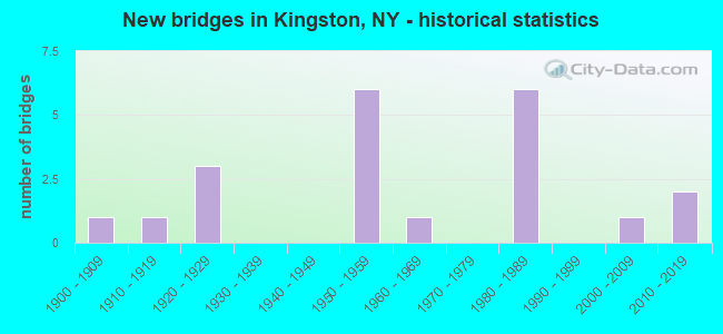
- New bridges - historical statistics
- 11900-1909
- 11910-1919
- 31920-1929
- 61950-1959
- 11960-1969
- 61980-1989
- 12000-2009
- 22010-2019

- Reconstructed bridges - Historical Statistics
- 11970-1979
- 11980-1989


- Bridge Condition - Deck
- 20.0%Good
- 40.0%Satisfactory
- 20.0%Fair
- 10.0%Poor
- 10.0%Serious

- Bridge Condition - Superstructure
- 10.0%Excellent
- 30.0%Very good
- 20.0%Good
- 10.0%Satisfactory
- 20.0%Fair
- 10.0%Serious

- Bridge Condition - Substructure
- 10.0%Very good
- 30.0%Good
- 40.0%Satisfactory
- 10.0%Fair
- 10.0%Serious

- Bridge Condition - Channel
- 33.3%Very good
- 33.3%Good
- 33.3%Satisfactory
Find on map >> Show street view
Structure Number: 100735, Location: 12.5MI N JCT RTS 9W+299 (Lat: 41.915294, Lng: -73.983367), Route carried "on" structure: City street 984, Year Built: 1921, Year Reconstructed: 1975, Status: Closed, Structure Length: 32.40m (106.30ft), Average Daily Traffic: 5,215 (year 2020), Truck Traffic: 2%, Average Future Daily Traffic: 6,335 (year 2040), Design Load: HS 20, Features Intersected: DOCK STREET, RONDOUT CRE
Minimum Vertical Clearance: 5.63m (18.47ft), Kilometerpoint: 0.579, Lanes on structure: 2, Lanes under structure: 1, Base Highway Network: Yes, Owner: State Highway Agency, Approaching Roadway Width: 7.3m (24.0ft), Navigation Control: Yes ( Vertical Clearance: 21.3m (69.9ft), Horizontal Clearance: 48.7m (159.8ft)), Material/Design: Steel continuous, Design/Construction: Suspension, Number Of Spans In Main Unit: 3, Length of Maximum Span: 214.8m (704.7ft), Curb or Sidewalk Widths: Left: 2.0m (6.6ft), Right: 2.0m (6.6ft), Curb-To-Curb Width: 7.4m (24.3ft), Out-to-Out Width: 11.4m (37.4ft)
Condition: Deck: Serious, Superstructure: Serious, Substructure: Serious, Channel: Very good, Waterway Adequacy: Equal to present desirable criteria, Approach Roadway Alignment: Meets minimum limits, Bridge Posting: Required (Relationship of Operating Rating to Maximum Legal Load: > 39.9% below), Length Of Structure Improvement: 32.40m (106.30ft), Designated Inspection Frequency: Every 12 months, Critical Feature Inspection Frequency: Every 12 months, Inspection Date: September 2021, Critical Feature Inspection Date: September 2021, Bridge Improvement Cost: $35,266,000, Roadway Improvement Cost: $20,652,000, Total Project Cost: $55,918,000 ( Estimate for 2021), Deck Structure Type: Concrete Precast Panels, Wearing Surface/Protective System: Wearing Surface: Bituminous, Membrane: Other
Find on map >> Show street view
Structure Number: 101959, Location: 1.7 MI E JCT SH28 & I87 (Lat: 41.934353, Lng: -74.011619), Route carried "on" structure: Interstate 28, Year Built: 2006, Status: Open, Structure Length: 2.83m (9.28ft), Average Daily Traffic: 14,618 (year 2015), Truck Traffic: 5%, Average Future Daily Traffic: 20,465 (year 2035), Design Load: HS 25 or greater, Features Intersected: Midtown Linear Park
Minimum Vertical Clearance: 30+ m (98+ ft), Kilometerpoint: 0.177, Lanes on structure: 4, Base Highway Network: Yes, Owner: State Highway Agency, Approaching Roadway Width: 26.5m (86.9ft), Skew: 22 degrees, Material/Design: Prestressed concrete, Design/Construction: Box Beam or Girders - Multiple, Number Of Spans In Main Unit: 1, Length of Maximum Span: 27.0m (88.6ft), Curb-To-Curb Width: 26.4m (86.6ft), Out-to-Out Width: 28.1m (92.2ft)
Condition: Deck: Satisfactory, Superstructure: Good, Substructure: Good, Operating Rating: 45.0 metric tons, Method Used To Determine Operating Rating: Load and Resistance Factor Rating (LRFR) rating reported by rating factor(RF) method using HL-93 loadings, Inventory Rating: 34.7 metric tons, Method Used To Determine Inventory Rating: Load and Resistance Factor Rating (LRFR) rating reported by rating factor(RF) method using HL-93 loadings, Structural Evaluation: Better than present minimum criteria, Deck Geometry: Superior to present desirable criteria, Approach Roadway Alignment: Equal to present desirable criteria, Length Of Structure Improvement: 2.83m (9.28ft), Designated Inspection Frequency: Every 24 months, Inspection Date: July 2020, Bridge Improvement Cost: $3,072,000, Roadway Improvement Cost: $1,799,000, Total Project Cost: $4,871,000 ( Estimate for 2021), Wearing Surface/Protective System: Wearing Surface: Monolithic Concrete
Find on map >> Show street view
Structure Number: 105003, Location: 0.8 MI S JCT RTS 28+I87 (Lat: 41.938989, Lng: -74.026894), Route carried "on" structure: State highway 981K, Year Built: 1962, Status: Open, Structure Length: 8.17m (26.80ft), Average Daily Traffic: 17,723 (year 2020), Truck Traffic: 5%, Average Future Daily Traffic: 21,529 (year 2040), Design Load: H 20, Features Intersected: ESOPUS CREEK
Minimum Vertical Clearance: 30+ m (98+ ft), Kilometerpoint: 0.370, Lanes on structure: 4, Base Highway Network: Yes, Owner: State Highway Agency, Approaching Roadway Width: 21.3m (69.9ft), Skew: 21 degrees, Material/Design: Steel, Design/Construction: Stringer/Multi-beam, Number Of Spans In Main Unit: 3, Length of Maximum Span: 26.5m (86.9ft), Curb-To-Curb Width: 18.1m (59.4ft), Out-to-Out Width: 19.4m (63.6ft)
Condition: Deck: Satisfactory, Superstructure: Fair, Substructure: Satisfactory, Channel: Satisfactory, Operating Rating: 93.4 metric tons, Method Used To Determine Operating Rating: Load Factor (LF), Inventory Rating: 55.3 metric tons, Method Used To Determine Inventory Rating: Load Factor (LF), Structural Evaluation: Somewhat better than minimum adequacy, Deck Geometry: Somewhat better than minimum adequacy, Waterway Adequacy: Superior to present desirable criteria, Approach Roadway Alignment: Equal to present desirable criteria, Length Of Structure Improvement: 8.16m (26.77ft), Designated Inspection Frequency: Every 24 months, Inspection Date: November 2020, Bridge Improvement Cost: $6,007,000, Roadway Improvement Cost: $3,517,000, Total Project Cost: $9,524,000 ( Estimate for 2021), Deck Structure Type: Concrete Cast-file-Place, Wearing Surface/Protective System: Wearing Surface: Bituminous
Find on map >> Show street view
Structure Number: 107068, Location: IN CITY OF KINGSTON (Lat: 41.926719, Lng: -73.986044), Route carried "on" structure: City street , Year Built: 1982, Status: Open, Structure Length: 6.49m (21.29ft), Average Daily Traffic: 6,302 (year 2020), Truck Traffic: 3%, Average Future Daily Traffic: 6,331 (year 2040), Design Load: HS 20, Features Intersected: 9W 9W86032007 NB, RTE 9, Facility Carried by Structure: DELAWARE AVENUE
Minimum Vertical Clearance: 30+ m (98+ ft), Kilometerpoint: 0.306, Lanes on structure: 3, Lanes under structure: 6, Owner: State Highway Agency, Approaching Roadway Width: 17.1m (56.1ft), Skew: 22 degrees, Material/Design: Steel continuous, Design/Construction: Stringer/Multi-beam, Number Of Spans In Main Unit: 2, Length of Maximum Span: 31.6m (103.7ft), Curb or Sidewalk Widths: Left: 0.0m, Right: 3.0m (9.8ft), Curb-To-Curb Width: 17.1m (56.1ft), Out-to-Out Width: 20.9m (68.6ft)
Condition: Deck: Satisfactory, Superstructure: Very good, Substructure: Good, Operating Rating: 88.9 metric tons, Method Used To Determine Operating Rating: Load Factor (LF), Inventory Rating: 53.5 metric tons, Method Used To Determine Inventory Rating: Load Factor (LF), Structural Evaluation: Better than present minimum criteria, Deck Geometry: Superior to present desirable criteria, Underclear: Meets minimum limits, Approach Roadway Alignment: Equal to present desirable criteria, Length Of Structure Improvement: 6.49m (21.29ft), Designated Inspection Frequency: Every 24 months, Inspection Date: May 2021, Bridge Improvement Cost: $5,359,000, Roadway Improvement Cost: $3,138,000, Total Project Cost: $8,498,000 ( Estimate for 2021), Deck Structure Type: Concrete Cast-file-Place, Wearing Surface/Protective System: Wearing Surface: Integral Concrete, Deck Protection: Epoxy Coated Reinforcing
Find on map >> Show street view
Structure Number: 1070699, Location: CITY OF KINGSTON (Lat: 41.936678, Lng: -73.983458), Route carried "on" structure: US 9W, Year Built: 1981, Status: Open, Structure Length: 3.11m (10.20ft), Average Daily Traffic: 17,302 (year 2020), Truck Traffic: 6%, Average Future Daily Traffic: 17,383 (year 2040), Design Load: HS 20, Features Intersected: LINCOLN STREET
Minimum Vertical Clearance: 30+ m (98+ ft), Kilometerpoint: 40.209, Lanes on structure: 4, Lanes under structure: 2, Base Highway Network: Yes, Owner: State Highway Agency, Approaching Roadway Width: 21.6m (70.9ft), Skew: 30 degrees, Material/Design: Steel, Design/Construction: Stringer/Multi-beam, Number Of Spans In Main Unit: 1, Length of Maximum Span: 30.5m (100.1ft), Curb-To-Curb Width: 29.0m (95.1ft), Out-to-Out Width: 30.5m (100.1ft)
Condition: Deck: Satisfactory, Superstructure: Very good, Substructure: Good, Inventory Rating: 65.3 metric tons, Method Used To Determine Inventory Rating: Load Factor (LF), Structural Evaluation: Better than present minimum criteria, Deck Geometry: Superior to present desirable criteria, Underclear: Somewhat better than minimum adequacy, Approach Roadway Alignment: Equal to present desirable criteria, Length Of Structure Improvement: 3.10m (10.17ft), Designated Inspection Frequency: Every 24 months, Inspection Date: May 2021, Bridge Improvement Cost: $4,803,000, Roadway Improvement Cost: $2,812,000, Total Project Cost: $7,615,000 ( Estimate for 2021), Deck Structure Type: Concrete Cast-file-Place, Wearing Surface/Protective System: Wearing Surface: Integral Concrete, Deck Protection: Epoxy Coated Reinforcing
Find on map >> Show street view
Structure Number: 201958, Location: AT KINGSTON (Lat: 41.928694, Lng: -74.002244), Route carried "on" structure: City street , Year Built: 2017, Status: Open, Structure Length: 2.77m (9.09ft), Truck Traffic: 2%, Design Load: HL 93, Features Intersected: BROADWAY RTE 28, Facility Carried by Structure: GREENKILL AVENUE
Minimum Vertical Clearance: 30+ m (98+ ft), Kilometerpoint: 0.000, Lanes on structure: 2, Lanes under structure: 4, Owner: City or Municipal Highway Agency, Approaching Roadway Width: 7.3m (24.0ft), Skew: 2 degrees, Material/Design: Steel, Design/Construction: Stringer/Multi-beam, Number Of Spans In Main Unit: 1, Length of Maximum Span: 26.5m (86.9ft), Curb or Sidewalk Widths: Left: 1.5m (4.9ft), Right: 0.0m, Curb-To-Curb Width: 9.8m (32.2ft), Out-to-Out Width: 12.1m (39.7ft)
Condition: Deck: Good, Superstructure: Excellent, Substructure: Very good, Operating Rating: 73.9 metric tons, Method Used To Determine Operating Rating: Load and Resistance Factor Rating (LRFR) rating reported by rating factor(RF) method using HL-93 loadings, Inventory Rating: 57.7 metric tons, Method Used To Determine Inventory Rating: Load and Resistance Factor Rating (LRFR) rating reported by rating factor(RF) method using HL-93 loadings, Structural Evaluation: Equal to present desirable criteria, Deck Geometry: Equal to present desirable criteria, Underclear: Somewhat better than minimum adequacy, Approach Roadway Alignment: Equal to present desirable criteria, Length Of Structure Improvement: 2.77m (9.09ft), Designated Inspection Frequency: Every 24 months, Inspection Date: October 2021, Bridge Improvement Cost: $2,208,000, Roadway Improvement Cost: $1,293,000, Total Project Cost: $3,502,000 ( Estimate for 2021), Deck Structure Type: Concrete Cast-file-Place, Wearing Surface/Protective System: Wearing Surface: Integral Concrete, Deck Protection: Epoxy Coated Reinforcing
Find on map >> Show street view
Structure Number: 5515479, Location: 0.4 MI SW JCT I-87 < 22 (Lat: 41.938875, Lng: -74.036481), Route carried "on" structure: Interstate 87, Year Built: 1953, Status: Open, Structure Length: 4.08m (13.39ft), Average Daily Traffic: 32,350 (year 2018), Truck Traffic: 18%, Average Future Daily Traffic: 54,781 (year 2040), Design Load: HS 20+Mod, Features Intersected: HURLEY AVE
Minimum Vertical Clearance: 30+ m (98+ ft), Kilometerpoint: 38.761, Lanes on structure: 4, Lanes under structure: 2, Base Highway Network: Yes, Toll: On Interstate toll segment, Owner: State Toll Authority, Approaching Roadway Width: 34.1m (111.9ft), Skew: 31 degrees, Material/Design: Steel, Design/Construction: Stringer/Multi-beam, Number Of Spans In Main Unit: 3, Length of Maximum Span: 19.8m (65.0ft), Curb-To-Curb Width: 29.9m (98.1ft), Out-to-Out Width: 34.4m (112.9ft)
Condition: Deck: Poor, Superstructure: Fair, Substructure: Fair, Operating Rating: 38.6 metric tons, Method Used To Determine Operating Rating: Load and Resistance Factor Rating (LRFR) rating reported by rating factor(RF) method using HL-93 loadings, Inventory Rating: 29.8 metric tons, Method Used To Determine Inventory Rating: Load and Resistance Factor Rating (LRFR) rating reported by rating factor(RF) method using HL-93 loadings, Structural Evaluation: Somewhat better than minimum adequacy, Deck Geometry: Superior to present desirable criteria, Underclear: Meets minimum limits, Approach Roadway Alignment: Equal to present desirable criteria, Length Of Structure Improvement: 4.08m (13.39ft), Designated Inspection Frequency: Every 24 months, Inspection Date: April 2020, Bridge Improvement Cost: $6,172,000, Roadway Improvement Cost: $3,614,000, Total Project Cost: $9,786,000 ( Estimate for 2021), Deck Structure Type: Concrete Cast-file-Place, Wearing Surface/Protective System: Wearing Surface: Bituminous, Membrane: Other
Find on map >> Show street view
Structure Number: 5515489, Location: 1.4 MI NW OF KINGSTON (Lat: 41.939878, Lng: -74.035661), Route carried "on" structure: Interstate 87, Year Built: 1954, Status: Open, Structure Length: 1.31m (4.30ft), Average Daily Traffic: 32,350 (year 2018), Truck Traffic: 18%, Average Future Daily Traffic: 54,781 (year 2040), Design Load: HS 20+Mod, Features Intersected: EX-N Y CENTRAL RR
Minimum Vertical Clearance: 30+ m (98+ ft), Kilometerpoint: 38.906, Lanes on structure: 4, Base Highway Network: Yes, Toll: On Interstate toll segment, Owner: State Toll Authority, Approaching Roadway Width: 33.1m (108.6ft), Skew: 33 degrees, Material/Design: Steel, Design/Construction: Stringer/Multi-beam, Number Of Spans In Main Unit: 1, Length of Maximum Span: 12.5m (41.0ft), Curb-To-Curb Width: 33.1m (108.6ft), Out-to-Out Width: 34.5m (113.2ft)
Condition: Deck: Fair, Superstructure: Good, Substructure: Satisfactory, Operating Rating: 41.7 metric tons, Method Used To Determine Operating Rating: Load Factor (LF), Inventory Rating: 24.5 metric tons, Method Used To Determine Inventory Rating: Load Factor (LF), Structural Evaluation: Equal to present minimum criteria, Deck Geometry: Superior to present desirable criteria, Approach Roadway Alignment: Equal to present desirable criteria, Length Of Structure Improvement: 1.31m (4.30ft), Designated Inspection Frequency: Every 24 months, Inspection Date: July 2020, Bridge Improvement Cost: $7,348,000, Roadway Improvement Cost: $4,303,000, Total Project Cost: $11,651,000 ( Estimate for 2021), Deck Structure Type: Concrete Cast-file-Place, Wearing Surface/Protective System: Wearing Surface: Bituminous, Membrane: Other
Find on map >> Show street view
Structure Number: 5515499, Location: 1.4 MI NW OF KINGSTON (Lat: 41.940417, Lng: -74.034931), Route carried "on" structure: Interstate 87, Year Built: 1954, Status: Open, Structure Length: 1.13m (3.71ft), Average Daily Traffic: 32,350 (year 2018), Truck Traffic: 18%, Average Future Daily Traffic: 54,781 (year 2040), Design Load: HS 20+Mod, Features Intersected: EX-ULSTER & DELWR
Minimum Vertical Clearance: 30+ m (98+ ft), Kilometerpoint: 38.986, Lanes on structure: 4, Base Highway Network: Yes, Toll: On Interstate toll segment, Owner: State Toll Authority, Approaching Roadway Width: 30.5m (100.1ft), Skew: 31 degrees, Material/Design: Steel, Design/Construction: Stringer/Multi-beam, Number Of Spans In Main Unit: 1, Length of Maximum Span: 10.7m (35.1ft), Curb-To-Curb Width: 32.9m (107.9ft), Out-to-Out Width: 34.5m (113.2ft)
Condition: Deck: Fair, Superstructure: Satisfactory, Substructure: Satisfactory, Operating Rating: 56.2 metric tons, Method Used To Determine Operating Rating: Load Factor (LF), Inventory Rating: 36.3 metric tons, Method Used To Determine Inventory Rating: Load Factor (LF), Structural Evaluation: Equal to present minimum criteria, Deck Geometry: Superior to present desirable criteria, Approach Roadway Alignment: Equal to present desirable criteria, Length Of Structure Improvement: 1.12m (3.67ft), Designated Inspection Frequency: Every 24 months, Inspection Date: July 2020, Bridge Improvement Cost: $6,065,000, Roadway Improvement Cost: $3,552,000, Total Project Cost: $9,616,000 ( Estimate for 2021), Deck Structure Type: Concrete Cast-file-Place, Wearing Surface/Protective System: Wearing Surface: Bituminous, Membrane: Other
Find on map >> Show street view
Structure Number: 5515509, Location: IN THE CITY OF KINGSTON (Lat: 41.943969, Lng: -74.032194), Route carried "on" structure: Interstate 87, Year Built: 1953, Year Reconstructed: 1994, Status: Open, Structure Length: 9.60m (31.50ft), Average Daily Traffic: 32,350 (year 2018), Truck Traffic: 18%, Average Future Daily Traffic: 54,781 (year 2040), Design Load: HS 20+Mod, Features Intersected: ESOPUS CREEK
Minimum Vertical Clearance: 30+ m (98+ ft), Kilometerpoint: 39.421, Lanes on structure: 4, Base Highway Network: Yes, Toll: On Interstate toll segment, Owner: State Toll Authority, Approaching Roadway Width: 32.6m (107.0ft), Skew: 20 degrees, Material/Design: Steel continuous, Design/Construction: Stringer/Multi-beam, Number Of Spans In Main Unit: 3, Length of Maximum Span: 35.1m (115.2ft), Curb-To-Curb Width: 32.7m (107.3ft), Out-to-Out Width: 34.4m (112.9ft)
Condition: Deck: Good, Superstructure: Very good, Substructure: Satisfactory, Channel: Good, Operating Rating: 47.2 metric tons, Method Used To Determine Operating Rating: Load Factor (LF), Inventory Rating: 21.8 metric tons, Method Used To Determine Inventory Rating: Load Factor (LF), Structural Evaluation: Somewhat better than minimum adequacy, Deck Geometry: Superior to present desirable criteria, Waterway Adequacy: Meets minimum limits, Approach Roadway Alignment: Equal to present desirable criteria, Length Of Structure Improvement: 9.60m (31.50ft), Designated Inspection Frequency: Every 24 months, Inspection Date: May 2020, Bridge Improvement Cost: $12,372,000, Roadway Improvement Cost: $7,245,000, Total Project Cost: $19,617,000 ( Estimate for 2021), Deck Structure Type: Concrete Cast-file-Place, Wearing Surface/Protective System: Wearing Surface: Bituminous, Membrane: Other, Deck Protection: Epoxy Coated Reinforcing
Find on map >> Show street view
Structure Number: 100735, Location: 12.5MI N JCT RTS 9W+299 (Lat: 41.915294, Lng: -73.983367), Route carried "under" structure: City street , Year Built: 1921, Structure Length: 0. m, Average Daily Traffic: 289 (year 2018), Truck Traffic: 1%, Features Intersected: DOCK STREET, RONDOUT CRE, Facility Carried by Structure: RTE 984
Minimum Vertical Clearance: 17.99m (59.02ft), Kilometerpoint: 0.000, Lanes on structure: 2, Lanes under structure: 1, Material/Design: Steel continuous, Design/Construction: Suspension, Length of Maximum Span: 214.8m (704.7ft)
Find on map >> Show street view
Structure Number: 107068, Location: IN CITY OF KINGSTON (Lat: 41.926719, Lng: -73.986044), Route carried "under" structure: US 9W, Year Built: 1982, Structure Length: 0. m, Average Daily Traffic: 15,056 (year 2000), Features Intersected: 9W 9W86032007 NB, RTE 9, Facility Carried by Structure: DELAWARE AVENUE
Minimum Vertical Clearance: 7.29m (23.92ft), Kilometerpoint: 1.062, Lanes on structure: 3, Lanes under structure: 3, Material/Design: Steel continuous, Design/Construction: Stringer/Multi-beam, Length of Maximum Span: 31.6m (103.7ft)
Find on map >> Show street view
Structure Number: 1070699, Location: CITY OF KINGSTON (Lat: 41.936678, Lng: -73.983458), Route carried "under" structure: City street , Year Built: 1981, Structure Length: 0. m, Average Daily Traffic: 500 (year 2021), Features Intersected: LINCOLN STREET, Facility Carried by Structure: RTE 9W
Minimum Vertical Clearance: 4.85m (15.91ft), Kilometerpoint: 0.000, Lanes on structure: 4, Lanes under structure: 2, Material/Design: Steel, Design/Construction: Stringer/Multi-beam, Length of Maximum Span: 30.5m (100.1ft)
Find on map >> Show street view
Structure Number: 201958, Location: AT KINGSTON (Lat: 41.928694, Lng: -74.002244), Route carried "under" structure: City street , Year Built: 2017, Structure Length: 0. m, Average Daily Traffic: 14,500 (year 1973), Features Intersected: BROADWAY RTE 28, Facility Carried by Structure: GREENKILL AVENUE
Minimum Vertical Clearance: 5.03m (16.50ft), Kilometerpoint: 0.000, Lanes on structure: 2, Lanes under structure: 4, Material/Design: Steel, Design/Construction: Stringer/Multi-beam, Length of Maximum Span: 26.5m (86.9ft)
Find on map >> Show street view
Structure Number: 5515479, Location: 0.4 MI SW JCT I-87 < 22 (Lat: 41.938875, Lng: -74.036481), Route carried "under" structure: City street , Year Built: 1953, Structure Length: 0. m, Average Daily Traffic: 4,018 (year 2018), Truck Traffic: 4%, Features Intersected: HURLEY AVE, Facility Carried by Structure: RTE I87
Minimum Vertical Clearance: 4.32m (14.17ft), Kilometerpoint: 0.000, Lanes on structure: 4, Lanes under structure: 2, Material/Design: Steel, Design/Construction: Stringer/Multi-beam, Length of Maximum Span: 19.8m (65.0ft)
Find on map >> Show street view
Structure Number: 701958, Location: AT KINGSTON (Lat: 41.928611, Lng: -74.002028), Route carried "under" structure: City street , Year Built: 1952, Structure Length: 0. m, Average Daily Traffic: 14,500 (year 1973), Features Intersected: BROADWAY RTE 28, Facility Carried by Structure: CSXT RIVER LINE
Minimum Vertical Clearance: 4.26m (13.98ft), Kilometerpoint: 0.901, Lanes under structure: 4, Material/Design: Steel, Design/Construction: Girder and Floorbeam System, Length of Maximum Span: 28.9m (94.8ft)
Find on map >> Show street view
Structure Number: 770213, Location: IN CITY OF KINGSTON (Lat: 41.926436, Lng: -73.985883), Route carried "under" structure: US 9W, Year Built: 1982, Structure Length: 0. m, Average Daily Traffic: 15,056 (year 2000), Features Intersected: 9W 9W86031244 NB, RTE 9, Facility Carried by Structure: Kingston Point Rai
Minimum Vertical Clearance: 5.05m (16.57ft), Kilometerpoint: 1.030, Lanes under structure: 3, Material/Design: Steel continuous, Design/Construction: Girder and Floorbeam System, Length of Maximum Span: 30.7m (100.7ft)
Find on map >> Show street view
Structure Number: 770213, Location: IN CITY OF KINGSTON (Lat: 41.926436, Lng: -73.985883), Route carried "under" structure: US , Year Built: 1982, Structure Length: 0. m, Features Intersected: 9W 9W86031244 NB, RTE 9, Facility Carried by Structure: Kingston Point Rai
Minimum Vertical Clearance: 5.18m (16.99ft), Kilometerpoint: 1.030, Lanes under structure: 3, Material/Design: Steel continuous, Design/Construction: Girder and Floorbeam System, Length of Maximum Span: 30.7m (100.7ft)
Find on map >> Show street view
Structure Number: 771334, Location: 0.5 MI SW OF KINGSTON (Lat: 41.911389, Lng: -74.000253), Route carried "under" structure: Other road , Year Built: 1903, Structure Length: 0. m, Average Daily Traffic: 5,626 (year 2020), Truck Traffic: 5%, Features Intersected: ABEEL STREET, RONDOUT CR, Facility Carried by Structure: CSX TRANSPRTATION
Minimum Vertical Clearance: 30.48m (100.00ft), Kilometerpoint: 1.126, Lanes under structure: 4, Material/Design: Steel, Design/Construction: Truss - Thru, Length of Maximum Span: 82.2m (269.7ft)
Find on map >> Show street view
Structure Number: 771335, Location: 1.0 MI S OF KINGSTON (Lat: 41.915928, Lng: -74.006728), Route carried "under" structure: City street , Year Built: 1929, Structure Length: 0. m, Average Daily Traffic: 1,967 (year 2018), Truck Traffic: 2%, Features Intersected: WEST OREILLY ST, Facility Carried by Structure: CSXT RIVER LINE
Minimum Vertical Clearance: 3.47m (11.38ft), Kilometerpoint: 0.434, Lanes under structure: 2, Material/Design: Steel, Design/Construction: Girder and Floorbeam System, Length of Maximum Span: 10.3m (33.8ft)
Find on map >> Show street view
Structure Number: 77134, Location: AT KINGSTON (Lat: 41.921481, Lng: -73.983642), Route carried "under" structure: City street , Year Built: 1916, Structure Length: 0. m, Average Daily Traffic: 5,378 (year 2019), Truck Traffic: 4%, Features Intersected: MEADOW STREET, Facility Carried by Structure: EX-CATSKILL MT RR
Minimum Vertical Clearance: 3.35m (10.99ft), Kilometerpoint: 0.000, Lanes under structure: 2, Material/Design: Steel, Design/Construction: Girder and Floorbeam System, Length of Maximum Span: 17.0m (55.8ft)