Bridge Statistics for Kent, New York (NY)
Condition, Traffic, Stress, Structural Evaluation, Project Costs
- National Bridge Inventory (NBI) Statistics
- 21Number of bridges
- 118ft / 35.6mTotal length
- $31,015,000Total costs
- 213,146Total average daily traffic
- 20,331Total average daily truck traffic
- National Bridge Inventory (NBI) Registered Bridges for Kent
- No street view available for this location
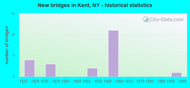
- New bridges - historical statistics
- 41920-1929
- 31930-1939
- 21950-1959
- 111960-1969
- 11990-1999

- Reconstructed bridges - Historical Statistics
- 11980-1989
- 21990-1999
- 12000-2009
- 12010-2019


- Bridge Condition - Deck
- 10.0%Excellent
- 10.0%Very good
- 20.0%Good
- 30.0%Satisfactory
- 30.0%Fair

- Bridge Condition - Superstructure
- 9.1%Excellent
- 9.1%Very good
- 18.2%Good
- 63.6%Satisfactory

- Bridge Condition - Substructure
- 27.3%Good
- 18.2%Satisfactory
- 45.5%Fair
- 9.1%Poor

- Bridge Condition - Channel
- 15.4%Good
- 46.2%Satisfactory
- 38.5%Fair

- Bridge Condition - Culverts
- 33.3%Good
- 50.0%Satisfactory
- 16.7%Fair
Find on map >> Show street view
Structure Number: 10453, Location: JCT RTE 301+TSP (Lat: 41.468064, Lng: -73.821231), Route carried "on" structure: State highway 301, Year Built: 1935, Status: Open, Structure Length: 2.26m (7.41ft), Average Daily Traffic: 2,864 (year 2018), Truck Traffic: 6%, Average Future Daily Traffic: 3,180 (year 2040), Design Load: H 20, Features Intersected: 987G 987G84021108, RTE 9
Minimum Vertical Clearance: 30+ m (98+ ft), Kilometerpoint: 13.837, Lanes on structure: 2, Lanes under structure: 4, Base Highway Network: Yes, Owner: State Highway Agency, Approaching Roadway Width: 8.5m (27.9ft), Material/Design: Concrete, Design/Construction: Arch - Deck, Number Of Spans In Main Unit: 1, Length of Maximum Span: 20.4m (66.9ft), Curb-To-Curb Width: 10.7m (35.1ft), Out-to-Out Width: 12.2m (40.0ft)
Condition: Superstructure: Satisfactory, Substructure: Satisfactory, Operating Rating: 59.1 metric tons, Method Used To Determine Operating Rating: Field evaluation and documented engineering judgment, Inventory Rating: 23.1 metric tons, Method Used To Determine Inventory Rating: Field evaluation and documented engineering judgment, Structural Evaluation: Equal to present minimum criteria, Deck Geometry: Somewhat better than minimum adequacy, Underclear: High priority of corrective action, Approach Roadway Alignment: Meets minimum limits, Length Of Structure Improvement: 2.25m (7.38ft), Designated Inspection Frequency: Every 24 months, Inspection Date: June 2021, Bridge Improvement Cost: $2,024,000, Roadway Improvement Cost: $1,185,000, Total Project Cost: $3,209,000 ( Estimate for 2021), Wearing Surface/Protective System: Wearing Surface: Bituminous
Find on map >> Show street view
Structure Number: 104531, Location: 4.2 MI E JCT SH 301 & TSP (Lat: 41.470544, Lng: -73.760019), Route carried "on" structure: State highway 301, Year Built: 1929, Year Reconstructed: 1989, Status: Open, Structure Length: 0.88m (2.89ft), Average Daily Traffic: 2,684 (year 2017), Truck Traffic: 4%, Average Future Daily Traffic: 2,980 (year 2040), Design Load: HS 20, Features Intersected: W BR CROTON RIVER
Minimum Vertical Clearance: 30+ m (98+ ft), Kilometerpoint: 20.499, Lanes on structure: 2, Base Highway Network: Yes, Owner: State Highway Agency, Approaching Roadway Width: 9.1m (29.9ft), Skew: 3 degrees, Material/Design: Steel, Design/Construction: Stringer/Multi-beam, Number Of Spans In Main Unit: 1, Length of Maximum Span: 7.3m (24.0ft), Curb-To-Curb Width: 9.1m (29.9ft), Out-to-Out Width: 9.7m (31.8ft)
Condition: Deck: Fair, Superstructure: Satisfactory, Substructure: Fair, Channel: Fair, Operating Rating: 98.0 metric tons, Method Used To Determine Operating Rating: Load Factor (LF), Inventory Rating: 58.1 metric tons, Method Used To Determine Inventory Rating: Load Factor (LF), Structural Evaluation: Somewhat better than minimum adequacy, Deck Geometry: Meets minimum limits, Waterway Adequacy: Meets minimum limits, Approach Roadway Alignment: Meets minimum limits, Length Of Structure Improvement: 0.88m (2.89ft), Designated Inspection Frequency: Every 24 months, Inspection Date: August 2021, Bridge Improvement Cost: $627,000, Roadway Improvement Cost: $367,000, Total Project Cost: $994,000 ( Estimate for 2021), Deck Structure Type: Concrete Cast-file-Place, Wearing Surface/Protective System: Wearing Surface: Bituminous
Find on map >> Show street view
Structure Number: 104532, Location: 6.6 MI E JCT RTS 301+TSP (Lat: 41.447344, Lng: -73.732214), Route carried "on" structure: State highway 301, Year Built: 1953, Status: Open, Structure Length: 1.65m (5.41ft), Average Daily Traffic: 3,998 (year 2018), Truck Traffic: 3%, Average Future Daily Traffic: 4,440 (year 2040), Design Load: H 20, Features Intersected: W BR.CROTON RIVER
Minimum Vertical Clearance: 30+ m (98+ ft), Kilometerpoint: 24.392, Lanes on structure: 2, Base Highway Network: Yes, Owner: State Highway Agency, Approaching Roadway Width: 11.6m (38.1ft), Skew: 3 degrees, Material/Design: Steel, Design/Construction: Stringer/Multi-beam, Number Of Spans In Main Unit: 1, Length of Maximum Span: 15.5m (50.9ft), Curb-To-Curb Width: 11.6m (38.1ft), Out-to-Out Width: 12.5m (41.0ft)
Condition: Deck: Satisfactory, Superstructure: Satisfactory, Substructure: Fair, Channel: Fair, Operating Rating: 46.3 metric tons, Method Used To Determine Operating Rating: Load Factor (LF), Inventory Rating: 28.1 metric tons, Method Used To Determine Inventory Rating: Load Factor (LF), Structural Evaluation: Somewhat better than minimum adequacy, Deck Geometry: Somewhat better than minimum adequacy, Waterway Adequacy: Meets minimum limits, Approach Roadway Alignment: Meets minimum limits, Length Of Structure Improvement: 1.64m (5.38ft), Designated Inspection Frequency: Every 24 months, Inspection Date: November 2020, Bridge Improvement Cost: $1,974,000, Roadway Improvement Cost: $1,156,000, Total Project Cost: $3,130,000 ( Estimate for 2021), Deck Structure Type: Concrete Cast-file-Place, Wearing Surface/Protective System: Wearing Surface: Bituminous, Membrane: Other
Find on map >> Show street view
Structure Number: 104559, Location: 0.3 MI W JCT RTS 311+I84 (Lat: 41.472181, Lng: -73.653775), Route carried "on" structure: State highway 311, Year Built: 1936, Status: Open, Structure Length: 1.01m (3.31ft), Average Daily Traffic: 8,456 (year 2019), Truck Traffic: 5%, Average Future Daily Traffic: 10,272 (year 2040), Design Load: H 20, Features Intersected: MIDDLE BR CROTON
Minimum Vertical Clearance: 30+ m (98+ ft), Kilometerpoint: 1.223, Lanes on structure: 2, Base Highway Network: Yes, Owner: State Highway Agency, Approaching Roadway Width: 9.8m (32.2ft), Skew: 4 degrees, Material/Design: Concrete, Design/Construction: Culvert, Number Of Spans In Main Unit: 2, Length of Maximum Span: 4.6m (15.1ft)
Condition: Channel: Fair, Culverts: Fair, Inventory Rating: 59.9 metric tons, Method Used To Determine Inventory Rating: Load Factor (LF), Structural Evaluation: Somewhat better than minimum adequacy, Waterway Adequacy: Superior to present desirable criteria, Approach Roadway Alignment: Meets minimum limits, Length Of Structure Improvement: 1.00m (3.28ft), Designated Inspection Frequency: Every 24 months, Inspection Date: October 2020, Bridge Improvement Cost: $892,000, Roadway Improvement Cost: $522,000, Total Project Cost: $1,414,000 ( Estimate for 2021)
Find on map >> Show street view
Structure Number: 1052741, Location: I84 INT 17 (Lat: 41.508156, Lng: -73.681181), Route carried "on" structure: Interstate 84, Year Built: 1969, Year Reconstructed: 2001, Status: Open, Structure Length: 3.96m (12.99ft), Average Daily Traffic: 27,488 (year 2001), Truck Traffic: 15%, Design Load: HS 20, Features Intersected: LUDNGTNVL RD-CR43
Minimum Vertical Clearance: 30+ m (98+ ft), Kilometerpoint: 94.770, Lanes on structure: 2, Lanes under structure: 2, Base Highway Network: Yes, Owner: State Highway Agency, Approaching Roadway Width: 11.9m (39.0ft), Skew: 1 degrees, Material/Design: Steel, Design/Construction: Stringer/Multi-beam, Number Of Spans In Main Unit: 3, Length of Maximum Span: 14.6m (47.9ft), Curb-To-Curb Width: 11.9m (39.0ft), Out-to-Out Width: 12.8m (42.0ft)
Condition: Deck: Good, Superstructure: Satisfactory, Substructure: Fair, Operating Rating: 56.7 metric tons, Method Used To Determine Operating Rating: Load and Resistance Factor Rating (LRFR) rating reported by rating factor(RF) method using HL-93 loadings, Inventory Rating: 43.7 metric tons, Method Used To Determine Inventory Rating: Load and Resistance Factor Rating (LRFR) rating reported by rating factor(RF) method using HL-93 loadings, Structural Evaluation: Somewhat better than minimum adequacy, Deck Geometry: Equal to present minimum criteria, Underclear: Meets minimum limits, Approach Roadway Alignment: Equal to present desirable criteria, Length Of Structure Improvement: 3.96m (12.99ft), Designated Inspection Frequency: Every 24 months, Inspection Date: August 2020, Bridge Improvement Cost: $1,963,000, Roadway Improvement Cost: $1,150,000, Total Project Cost: $3,113,000 ( Estimate for 2021), Deck Structure Type: Concrete Cast-file-Place, Wearing Surface/Protective System: Wearing Surface: Monolithic Concrete
Find on map >> Show street view
Structure Number: 1052742, Location: I84 INT 17 (Lat: 41.508150, Lng: -73.681653), Route carried "on" structure: Interstate 84, Year Built: 1969, Status: Open, Structure Length: 3.96m (12.99ft), Average Daily Traffic: 16,610 (year 2020), Truck Traffic: 20%, Average Future Daily Traffic: 28,127 (year 2040), Design Load: HS 20+Mod, Features Intersected: LUDINGTONVILLE RD
Minimum Vertical Clearance: 30+ m (98+ ft), Kilometerpoint: 0.547, Lanes on structure: 2, Lanes under structure: 2, Base Highway Network: Yes, Owner: State Highway Agency, Approaching Roadway Width: 11.9m (39.0ft), Skew: 1 degrees, Material/Design: Steel, Design/Construction: Stringer/Multi-beam, Number Of Spans In Main Unit: 3, Length of Maximum Span: 14.6m (47.9ft), Curb-To-Curb Width: 11.9m (39.0ft), Out-to-Out Width: 12.8m (42.0ft)
Condition: Deck: Satisfactory, Superstructure: Satisfactory, Substructure: Satisfactory, Operating Rating: 56.7 metric tons, Method Used To Determine Operating Rating: Load and Resistance Factor Rating (LRFR) rating reported by rating factor(RF) method using HL-93 loadings, Inventory Rating: 43.7 metric tons, Method Used To Determine Inventory Rating: Load and Resistance Factor Rating (LRFR) rating reported by rating factor(RF) method using HL-93 loadings, Structural Evaluation: Equal to present minimum criteria, Deck Geometry: Equal to present minimum criteria, Underclear: Meets minimum limits, Approach Roadway Alignment: Equal to present desirable criteria, Length Of Structure Improvement: 3.96m (12.99ft), Designated Inspection Frequency: Every 24 months, Inspection Date: August 2020, Bridge Improvement Cost: $1,963,000, Roadway Improvement Cost: $1,150,000, Total Project Cost: $3,113,000 ( Estimate for 2021), Deck Structure Type: Concrete Cast-file-Place, Wearing Surface/Protective System: Wearing Surface: Monolithic Concrete
Find on map >> Show street view
Structure Number: 105275, Location: 0.1 MI E I84 INT 17 (Lat: 41.496786, Lng: -73.667950), Route carried "on" structure: Other road , Year Built: 1968, Status: Open, Structure Length: 8.99m (29.49ft), Average Daily Traffic: 105 (year 2016), Truck Traffic: 4%, Average Future Daily Traffic: 147 (year 2036), Design Load: HS 20, Features Intersected: 84I 84I84031014, RTE I84, Facility Carried by Structure: BOWEN ROAD
Minimum Vertical Clearance: 30+ m (98+ ft), Kilometerpoint: 1.561, Lanes on structure: 2, Lanes under structure: 4, Owner: State Highway Agency, Approaching Roadway Width: 7.9m (25.9ft), Skew: 3 degrees, Material/Design: Steel, Design/Construction: Stringer/Multi-beam, Number Of Spans In Main Unit: 3, Length of Maximum Span: 33.8m (110.9ft), Curb or Sidewalk Widths: Left: 0.5m (1.6ft), Right: 0.5m (1.6ft), Curb-To-Curb Width: 7.3m (24.0ft), Out-to-Out Width: 8.8m (28.9ft)
Condition: Deck: Fair, Superstructure: Very good, Substructure: Good, Operating Rating: 43.1 metric tons, Method Used To Determine Operating Rating: Load and Resistance Factor Rating (LRFR) rating reported by rating factor(RF) method using HL-93 loadings, Inventory Rating: 33.4 metric tons, Method Used To Determine Inventory Rating: Load and Resistance Factor Rating (LRFR) rating reported by rating factor(RF) method using HL-93 loadings, Structural Evaluation: Better than present minimum criteria, Deck Geometry: Somewhat better than minimum adequacy, Underclear: High priority of corrective action, Approach Roadway Alignment: Equal to present desirable criteria, Length Of Structure Improvement: 8.99m (29.49ft), Designated Inspection Frequency: Every 24 months, Inspection Date: September 2020, Bridge Improvement Cost: $2,966,000, Roadway Improvement Cost: $1,737,000, Total Project Cost: $4,704,000 ( Estimate for 2021), Deck Structure Type: Concrete Cast-file-Place, Wearing Surface/Protective System: Wearing Surface: Integral Concrete
Find on map >> Show street view
Structure Number: 105276, Location: 2.3 MI NW EXIT 18 OF I84 (Lat: 41.481372, Lng: -73.653500), Route carried "on" structure: Interstate 84, Year Built: 1968, Status: Open, Structure Length: 2.07m (6.79ft), Average Daily Traffic: 38,673 (year 2020), Truck Traffic: 19%, Average Future Daily Traffic: 65,488 (year 2040), Design Load: HS 20, Features Intersected: STUMP POND STREAM
Minimum Vertical Clearance: 30+ m (98+ ft), Kilometerpoint: 4.537, Lanes on structure: 4, Base Highway Network: Yes, Owner: State Highway Agency, Approaching Roadway Width: 11.6m (38.1ft), Skew: 26 degrees, Material/Design: Concrete continuous, Design/Construction: Culvert, Number Of Spans In Main Unit: 2, Length of Maximum Span: 9.1m (29.9ft)
Condition: Channel: Satisfactory, Culverts: Good, Structural Evaluation: Better than present minimum criteria, Waterway Adequacy: Meets minimum limits, Approach Roadway Alignment: Equal to present desirable criteria, Length Of Structure Improvement: 2.07m (6.79ft), Designated Inspection Frequency: Every 24 months, Inspection Date: November 2020, Bridge Improvement Cost: $1,890,000, Roadway Improvement Cost: $1,107,000, Total Project Cost: $2,997,000 ( Estimate for 2021), Wearing Surface/Protective System: Wearing Surface: Bituminous
Find on map >> Show street view
Structure Number: 1091561, Location: 0.2 MI E JCT I84 INT 17 (Lat: 41.505628, Lng: -73.680022), Route carried "on" structure: Interstate 84, Year Built: 1968, Status: Open, Structure Length: 0.79m (2.59ft), Average Daily Traffic: 1,195 (year 2020), Truck Traffic: 10%, Average Future Daily Traffic: 2,023 (year 2040), Design Load: HS 20+Mod, Features Intersected: STUMP POND STREAM
Minimum Vertical Clearance: 30+ m (98+ ft), Kilometerpoint: 0.064, Lanes on structure: 3, Owner: State Highway Agency, Approaching Roadway Width: 18.3m (60.0ft), Skew: 22 degrees, Material/Design: Concrete, Design/Construction: Culvert, Number Of Spans In Main Unit: 1, Length of Maximum Span: 7.0m (23.0ft)
Condition: Channel: Satisfactory, Culverts: Satisfactory, Structural Evaluation: Equal to present minimum criteria, Waterway Adequacy: Meets minimum limits, Approach Roadway Alignment: Equal to present desirable criteria, Length Of Structure Improvement: 0.79m (2.59ft), Designated Inspection Frequency: Every 24 months, Inspection Date: June 2020, Bridge Improvement Cost: $408,000, Roadway Improvement Cost: $239,000, Total Project Cost: $647,000 ( Estimate for 2021), Wearing Surface/Protective System: Wearing Surface: Bituminous
Find on map >> Show street view
Structure Number: 1091562, Location: 0.2 MI E JCT I84 INT 17 (Lat: 41.505606, Lng: -73.680675), Route carried "on" structure: Interstate 84, Year Built: 1968, Status: Open, Structure Length: 0.82m (2.69ft), Average Daily Traffic: 19,337 (year 2020), Truck Traffic: 19%, Average Future Daily Traffic: 32,744 (year 2040), Design Load: HS 20+Mod, Features Intersected: STUMP POND STREAM
Minimum Vertical Clearance: 30+ m (98+ ft), Kilometerpoint: 0.853, Lanes on structure: 3, Base Highway Network: Yes, Owner: State Highway Agency, Approaching Roadway Width: 14.0m (45.9ft), Skew: 32 degrees, Material/Design: Concrete, Design/Construction: Culvert, Number Of Spans In Main Unit: 1, Length of Maximum Span: 7.0m (23.0ft)
Condition: Channel: Satisfactory, Culverts: Satisfactory, Structural Evaluation: Equal to present minimum criteria, Waterway Adequacy: Meets minimum limits, Approach Roadway Alignment: Equal to present desirable criteria, Length Of Structure Improvement: 0.82m (2.69ft), Designated Inspection Frequency: Every 24 months, Inspection Date: June 2020, Bridge Improvement Cost: $325,000, Roadway Improvement Cost: $190,000, Total Project Cost: $515,000 ( Estimate for 2021), Wearing Surface/Protective System: Wearing Surface: Bituminous
Find on map >> Show street view
Structure Number: 222381, Location: 3.2 MI SW OF LAKE CARMEL (Lat: 41.440658, Lng: -73.727094), Route carried "on" structure: Other road , Year Built: 1929, Year Reconstructed: 2007, Status: Open, Structure Length: 1.68m (5.51ft), Truck Traffic: 1%, Design Load: HS 20, Features Intersected: W BR CROTON RIVER, Facility Carried by Structure: DIXON ROAD
Minimum Vertical Clearance: 30+ m (98+ ft), Kilometerpoint: 0.032, Lanes on structure: 2, Owner: Local Agency, Approaching Roadway Width: 9.1m (29.9ft), Material/Design: Steel, Design/Construction: Stringer/Multi-beam, Number Of Spans In Main Unit: 1, Length of Maximum Span: 15.2m (49.9ft), Curb-To-Curb Width: 9.1m (29.9ft), Out-to-Out Width: 10.0m (32.8ft)
Condition: Deck: Very good, Superstructure: Good, Substructure: Good, Channel: Good, Operating Rating: 91.6 metric tons, Method Used To Determine Operating Rating: Load Factor (LF), Inventory Rating: 54.4 metric tons, Method Used To Determine Inventory Rating: Load Factor (LF), Structural Evaluation: Better than present minimum criteria, Deck Geometry: Better than present minimum criteria, Waterway Adequacy: Somewhat better than minimum adequacy, Approach Roadway Alignment: Meets minimum limits, Length Of Structure Improvement: 1.67m (5.48ft), Designated Inspection Frequency: Every 24 months, Inspection Date: October 2021, Bridge Improvement Cost: $1,032,000, Roadway Improvement Cost: $604,000, Total Project Cost: $1,637,000 ( Estimate for 2021), Deck Structure Type: Concrete Cast-file-Place, Wearing Surface/Protective System: Wearing Surface: Integral Concrete, Deck Protection: Epoxy Coated Reinforcing
Find on map >> Show street view
Structure Number: 222382, Location: 2.6 MI N OF LAKE CARMEL (Lat: 41.497800, Lng: -73.667244), Route carried "on" structure: Other road , Year Built: 1968, Status: Open, Structure Length: 1.04m (3.41ft), Average Daily Traffic: 105 (year 2016), Truck Traffic: 4%, Average Future Daily Traffic: 147 (year 2036), Design Load: HS 20, Features Intersected: DREW LAKE OUTLET, Facility Carried by Structure: BOWEN ROAD
Minimum Vertical Clearance: 30+ m (98+ ft), Kilometerpoint: 1.722, Lanes on structure: 2, Owner: Town or Township Highway Agency, Approaching Roadway Width: 8.5m (27.9ft), Material/Design: Concrete continuous, Design/Construction: Culvert, Number Of Spans In Main Unit: 2, Length of Maximum Span: 4.8m (15.7ft)
Condition: Channel: Satisfactory, Culverts: Good, Operating Rating: 97.2 metric tons, Method Used To Determine Operating Rating: Load and Resistance Factor Rating (LRFR) rating reported by rating factor(RF) method using HL-93 loadings, Inventory Rating: 84.9 metric tons, Method Used To Determine Inventory Rating: Load and Resistance Factor Rating (LRFR) rating reported by rating factor(RF) method using HL-93 loadings, Structural Evaluation: Better than present minimum criteria, Waterway Adequacy: Equal to present desirable criteria, Approach Roadway Alignment: Equal to present desirable criteria, Length Of Structure Improvement: 1.03m (3.38ft), Designated Inspection Frequency: Every 24 months, Inspection Date: May 2020, Bridge Improvement Cost: $249,000, Roadway Improvement Cost: $146,000, Total Project Cost: $395,000 ( Estimate for 2021)
Find on map >> Show street view
Structure Number: 334561, Location: AT LAKE CARMEL (Lat: 41.455094, Lng: -73.661133), Route carried "on" structure: Other road , Year Built: 1925, Year Reconstructed: 1995, Status: Open, Structure Length: 2.26m (7.41ft), Average Daily Traffic: 980 (year 2017), Truck Traffic: 3%, Average Future Daily Traffic: 1,372 (year 2037), Design Load: HS 20, Features Intersected: LAKE CARMEL OUTLET, Facility Carried by Structure: LAKE SHORE DRIVE
Minimum Vertical Clearance: 30+ m (98+ ft), Kilometerpoint: 1.030, Lanes on structure: 2, Owner: County Highway Agency, Approaching Roadway Width: 8.2m (26.9ft), Material/Design: Wood or Timber, Design/Construction: Slab, Number Of Spans In Main Unit: 2, Length of Maximum Span: 10.6m (34.8ft), Curb-To-Curb Width: 8.0m (26.2ft), Out-to-Out Width: 9.1m (29.9ft)
Condition: Deck: Satisfactory, Superstructure: Satisfactory, Substructure: Fair, Channel: Satisfactory, Operating Rating: 72.6 metric tons, Method Used To Determine Operating Rating: Load Factor (LF), Inventory Rating: 49.9 metric tons, Method Used To Determine Inventory Rating: Load Factor (LF), Structural Evaluation: Somewhat better than minimum adequacy, Deck Geometry: Somewhat better than minimum adequacy, Waterway Adequacy: Equal to present desirable criteria, Approach Roadway Alignment: Equal to present desirable criteria, Length Of Structure Improvement: 2.25m (7.38ft), Designated Inspection Frequency: Every 24 months, Inspection Date: April 2020, Bridge Improvement Cost: $654,000, Roadway Improvement Cost: $383,000, Total Project Cost: $1,037,000 ( Estimate for 2021), Wearing Surface/Protective System: Wearing Surface: Bituminous
Find on map >> Show street view
Structure Number: 334562, Location: 2.1 MILES SW OF HOLMES (Lat: 41.508147, Lng: -73.682378), Route carried "on" structure: County highway , Year Built: 1968, Status: Open, Structure Length: 0.73m (2.40ft), Average Daily Traffic: 7,946 (year 2020), Truck Traffic: 9%, Average Future Daily Traffic: 9,652 (year 2040), Design Load: HS 20, Features Intersected: STUMP POND STREAM, Facility Carried by Structure: LUDINGTONVILLE ROA
Minimum Vertical Clearance: 30+ m (98+ ft), Kilometerpoint: 5.438, Lanes on structure: 2, Owner: County Highway Agency, Approaching Roadway Width: 7.3m (24.0ft), Skew: 1 degrees, Material/Design: Concrete, Design/Construction: Culvert, Number Of Spans In Main Unit: 1, Length of Maximum Span: 7.0m (23.0ft), Curb-To-Curb Width: 14.1m (46.3ft), Out-to-Out Width: 15.0m (49.2ft)
Condition: Channel: Fair, Culverts: Satisfactory, Operating Rating: 77.1 metric tons, Method Used To Determine Operating Rating: Load Factor (LF), Inventory Rating: 46.3 metric tons, Method Used To Determine Inventory Rating: Load Factor (LF), Structural Evaluation: Equal to present minimum criteria, Deck Geometry: Superior to present desirable criteria, Waterway Adequacy: Equal to present desirable criteria, Approach Roadway Alignment: Equal to present desirable criteria, Length Of Structure Improvement: 0.73m (2.40ft), Designated Inspection Frequency: Every 24 months, Inspection Date: March 2020, Bridge Improvement Cost: $844,000, Roadway Improvement Cost: $494,000, Total Project Cost: $1,338,000 ( Estimate for 2021), Wearing Surface/Protective System: Wearing Surface: Bituminous
Find on map >> Show street view
Structure Number: 334563, Location: 5.0 MI NW OF L CARMEL (Lat: 41.492739, Lng: -73.749892), Route carried "on" structure: County highway , Year Built: 1958, Status: Open, Structure Length: 1.37m (4.49ft), Average Daily Traffic: 1,743 (year 2015), Truck Traffic: 5%, Average Future Daily Traffic: 1,818 (year 2040), Design Load: H 20, Features Intersected: SEVEN HILLS LAKE OUTLET, Facility Carried by Structure: FARMER MILLS ROAD
Minimum Vertical Clearance: 30+ m (98+ ft), Kilometerpoint: 1.995, Lanes on structure: 2, Owner: County Highway Agency, Approaching Roadway Width: 6.7m (22.0ft), Skew: 2 degrees, Material/Design: Steel, Design/Construction: Stringer/Multi-beam, Number Of Spans In Main Unit: 1, Length of Maximum Span: 12.1m (39.7ft), Curb or Sidewalk Widths: Left: 0.5m (1.6ft), Right: 0.5m (1.6ft), Curb-To-Curb Width: 7.9m (25.9ft), Out-to-Out Width: 9.5m (31.2ft)
Condition: Deck: Fair, Superstructure: Satisfactory, Substructure: Fair, Channel: Good, Operating Rating: 51.5 metric tons, Method Used To Determine Operating Rating: Load and Resistance Factor Rating (LRFR) rating reported by rating factor(RF) method using HL-93 loadings, Inventory Rating: 39.9 metric tons, Method Used To Determine Inventory Rating: Load and Resistance Factor Rating (LRFR) rating reported by rating factor(RF) method using HL-93 loadings, Structural Evaluation: Somewhat better than minimum adequacy, Deck Geometry: Meets minimum limits, Waterway Adequacy: Meets minimum limits, Approach Roadway Alignment: Better than present minimum criteria, Length Of Structure Improvement: 1.37m (4.49ft), Designated Inspection Frequency: Every 24 months, Inspection Date: May 2020, Bridge Improvement Cost: $1,044,000, Roadway Improvement Cost: $611,000, Total Project Cost: $1,655,000 ( Estimate for 2021), Deck Structure Type: Concrete Cast-file-Place, Wearing Surface/Protective System: Wearing Surface: Bituminous
Find on map >> Show street view
Structure Number: 336512, Location: 1.3 MI NE OF LAKE CARMEL (Lat: 41.475175, Lng: -73.652728), Route carried "on" structure: County highway , Year Built: 1925, Year Reconstructed: 2019, Status: Open, Structure Length: 0.94m (3.08ft), Average Daily Traffic: 416 (year 2016), Truck Traffic: 4%, Average Future Daily Traffic: 582 (year 2036), Features Intersected: DREW LAKE OUTLET, Facility Carried by Structure: LUDINGTON CT
Minimum Vertical Clearance: 30+ m (98+ ft), Kilometerpoint: 0.434, Lanes on structure: 2, Owner: Town or Township Highway Agency, Approaching Roadway Width: 6.1m (20.0ft), Material/Design: Wood or Timber, Design/Construction: Slab, Number Of Spans In Main Unit: 1, Length of Maximum Span: 9.1m (29.9ft), Curb-To-Curb Width: 6.6m (21.7ft), Out-to-Out Width: 7.2m (23.6ft)
Condition: Deck: Excellent, Superstructure: Excellent, Substructure: Poor, Channel: Fair, Operating Rating: 66.2 metric tons, Method Used To Determine Operating Rating: Allowable Stress (AS), Inventory Rating: 47.2 metric tons, Method Used To Determine Inventory Rating: Allowable Stress (AS), Structural Evaluation: Meets minimum limits, Deck Geometry: High priority of corrective action, Waterway Adequacy: Meets minimum limits, Approach Roadway Alignment: Meets minimum limits, Length Of Structure Improvement: 0.94m (3.08ft), Designated Inspection Frequency: Every 24 months, Inspection Date: May 2020, Bridge Improvement Cost: $318,000, Roadway Improvement Cost: $186,000, Total Project Cost: $504,000 ( Estimate for 2021), Deck Structure Type: Wood or Timber, Wearing Surface/Protective System: Wearing Surface: Bituminous
Find on map >> Show street view
Structure Number: 336842, Location: .9 MI E INT RTS 45 & 52 (Lat: 41.451417, Lng: -73.657644), Route carried "on" structure: County highway , Year Built: 1995, Status: Open, Structure Length: 1.16m (3.81ft), Average Daily Traffic: 1,208 (year 2020), Truck Traffic: 6%, Average Future Daily Traffic: 1,494 (year 2040), Design Load: HS 25 or greater, Features Intersected: M.BR.CROTON RIVER, Facility Carried by Structure: TOWNERS ROAD
Minimum Vertical Clearance: 30+ m (98+ ft), Kilometerpoint: 1.529, Lanes on structure: 2, Owner: County Highway Agency, Approaching Roadway Width: 7.3m (24.0ft), Material/Design: Prestressed concrete, Design/Construction: Slab, Number Of Spans In Main Unit: 1, Length of Maximum Span: 10.9m (35.8ft), Curb-To-Curb Width: 8.0m (26.2ft), Out-to-Out Width: 8.7m (28.5ft)
Condition: Deck: Good, Superstructure: Good, Substructure: Good, Channel: Satisfactory, Operating Rating: 43.7 metric tons, Method Used To Determine Operating Rating: Load and Resistance Factor Rating (LRFR) rating reported by rating factor(RF) method using HL-93 loadings, Inventory Rating: 33.7 metric tons, Method Used To Determine Inventory Rating: Load and Resistance Factor Rating (LRFR) rating reported by rating factor(RF) method using HL-93 loadings, Structural Evaluation: Better than present minimum criteria, Deck Geometry: Meets minimum limits, Waterway Adequacy: Meets minimum limits, Approach Roadway Alignment: High priority of corrective action, Length Of Structure Improvement: 1.15m (3.77ft), Designated Inspection Frequency: Every 24 months, Inspection Date: April 2021, Bridge Improvement Cost: $387,000, Roadway Improvement Cost: $226,000, Total Project Cost: $613,000 ( Estimate for 2021), Wearing Surface/Protective System: Wearing Surface: Bituminous, Membrane: Other
Find on map >> Show street view
Structure Number: 10453, Location: JCT RTE 301+TSP (Lat: 41.468064, Lng: -73.821231), Route carried "under" structure: State lands road 987G, Year Built: 1935, Structure Length: 0. m, Average Daily Traffic: 22,115 (year 2002), Features Intersected: 987G 987G84021108, RTE 9, Facility Carried by Structure: RTE 301
Minimum Vertical Clearance: 5.11m (16.77ft), Kilometerpoint: 17.377, Lanes on structure: 2, Lanes under structure: 2, Material/Design: Concrete, Design/Construction: Arch - Deck, Length of Maximum Span: 20.4m (66.9ft)
Find on map >> Show street view
Structure Number: 1052741, Location: I84 INT 17 (Lat: 41.508156, Lng: -73.681181), Route carried "under" structure: County highway , Year Built: 1969, Structure Length: 0. m, Average Daily Traffic: 2,000 (year 1982), Features Intersected: LUDNGTNVL RD-CR43, Facility Carried by Structure: RTE I84
Minimum Vertical Clearance: 4.98m (16.34ft), Kilometerpoint: 0.000, Lanes on structure: 2, Lanes under structure: 2, Material/Design: Steel, Design/Construction: Stringer/Multi-beam, Length of Maximum Span: 14.6m (47.9ft)
Find on map >> Show street view
Structure Number: 1052742, Location: I84 INT 17 (Lat: 41.508150, Lng: -73.681653), Route carried "under" structure: County highway , Year Built: 1969, Structure Length: 0. m, Average Daily Traffic: 100 (year 2021), Features Intersected: LUDINGTONVILLE RD, Facility Carried by Structure: RTE I84
Minimum Vertical Clearance: 4.95m (16.24ft), Kilometerpoint: 0.000, Lanes on structure: 2, Lanes under structure: 2, Material/Design: Steel, Design/Construction: Stringer/Multi-beam, Length of Maximum Span: 14.6m (47.9ft)
Find on map >> Show street view
Structure Number: 105275, Location: 0.1 MI E I84 INT 17 (Lat: 41.496786, Lng: -73.667950), Route carried "under" structure: Interstate 84, Year Built: 1968, Structure Length: 0. m, Average Daily Traffic: 55,123 (year 2014), Features Intersected: 84I 84I84031014, RTE I84, Facility Carried by Structure: BOWEN ROAD
Minimum Vertical Clearance: 6.50m (21.33ft), Kilometerpoint: 96.540, Lanes on structure: 2, Lanes under structure: 2, Material/Design: Steel, Design/Construction: Stringer/Multi-beam, Length of Maximum Span: 33.8m (110.9ft)