Bridge Statistics for Kennedy, New York (NY)
Condition, Traffic, Stress, Structural Evaluation, Project Costs
- National Bridge Inventory (NBI) Statistics
- 37Number of bridges
- 348ft / 106mTotal length
- $78,915,000Total costs
- 110,402Total average daily traffic
- 13,541Total average daily truck traffic
- National Bridge Inventory (NBI) Registered Bridges for Kennedy
- No street view available for this location
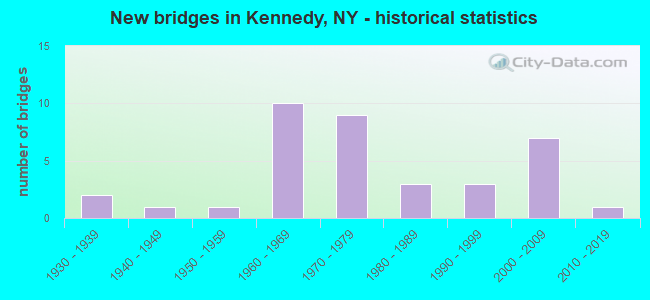
- New bridges - historical statistics
- 21930-1939
- 11940-1949
- 11950-1959
- 101960-1969
- 91970-1979
- 31980-1989
- 31990-1999
- 72000-2009
- 12010-2019

- Reconstructed bridges - Historical Statistics
- 21980-1989
- 01990-1999
- 02000-2009
- 72010-2019
- 12020-2022


- Bridge Condition - Deck
- 26.1%Excellent
- 13.0%Very good
- 30.4%Good
- 26.1%Satisfactory
- 4.3%Fair

- Bridge Condition - Superstructure
- 13.0%Excellent
- 30.4%Very good
- 21.7%Good
- 17.4%Satisfactory
- 17.4%Fair

- Bridge Condition - Substructure
- 17.4%Excellent
- 13.0%Very good
- 34.8%Good
- 30.4%Satisfactory
- 4.3%Poor

- Bridge Condition - Channel
- 36.8%Very good
- 21.1%Good
- 26.3%Satisfactory
- 10.5%Fair
- 5.3%Poor

- Bridge Condition - Culverts
- 50.0%Very good
- 50.0%Good
Find on map >> Show street view
Structure Number: 101213, Location: 3.4 MI NE JCT RTS 394+ 60 (Lat: 42.133964, Lng: -79.128397), Route carried "on" structure: State highway 394, Year Built: 1995, Status: Open, Structure Length: 1.68m (5.51ft), Average Daily Traffic: 2,202 (year 2017), Truck Traffic: 8%, Average Future Daily Traffic: 2,724 (year 2040), Design Load: HS 25 or greater, Features Intersected: DRY BROOK
Minimum Vertical Clearance: 30+ m (98+ ft), Kilometerpoint: 56.476, Lanes on structure: 2, Base Highway Network: Yes, Owner: State Highway Agency, Approaching Roadway Width: 11.6m (38.1ft), Skew: 1 degrees, Material/Design: Concrete, Design/Construction: Culvert, Number Of Spans In Main Unit: 3, Length of Maximum Span: 5.4m (17.7ft)
Condition: Channel: Satisfactory, Culverts: Very good, Operating Rating: 76.5 metric tons, Method Used To Determine Operating Rating: Field evaluation and documented engineering judgment, Inventory Rating: 40.8 metric tons, Method Used To Determine Inventory Rating: Field evaluation and documented engineering judgment, Structural Evaluation: Equal to present desirable criteria, Waterway Adequacy: Equal to present minimum criteria, Approach Roadway Alignment: Equal to present desirable criteria, Length Of Structure Improvement: 1.67m (5.48ft), Designated Inspection Frequency: Every 24 months, Inspection Date: June 2020, Bridge Improvement Cost: $947,000, Roadway Improvement Cost: $555,000, Total Project Cost: $1,502,000 ( Estimate for 2021), Wearing Surface/Protective System: Wearing Surface: Bituminous
Find on map >> Show street view
Structure Number: 101214, Location: 2.5 MI NE JCT RTS 394 &17 (Lat: 42.165672, Lng: -79.085881), Route carried "on" structure: State highway 394, Year Built: 1992, Status: Open, Structure Length: 0.91m (2.99ft), Average Daily Traffic: 2,183 (year 2016), Truck Traffic: 9%, Average Future Daily Traffic: 2,204 (year 2040), Design Load: HS 20, Features Intersected: INDIAN BROOK
Minimum Vertical Clearance: 30+ m (98+ ft), Kilometerpoint: 61.947, Lanes on structure: 2, Base Highway Network: Yes, Owner: State Highway Agency, Approaching Roadway Width: 9.1m (29.9ft), Skew: 4 degrees, Material/Design: Concrete, Design/Construction: Frame, Number Of Spans In Main Unit: 1, Length of Maximum Span: 8.5m (27.9ft), Curb-To-Curb Width: 9.1m (29.9ft), Out-to-Out Width: 22.6m (74.1ft)
Condition: Deck: Excellent, Superstructure: Very good, Substructure: Excellent, Channel: Very good, Operating Rating: 78.7 metric tons, Method Used To Determine Operating Rating: Field evaluation and documented engineering judgment, Inventory Rating: 32.7 metric tons, Method Used To Determine Inventory Rating: Field evaluation and documented engineering judgment, Structural Evaluation: Equal to present desirable criteria, Deck Geometry: Meets minimum limits, Waterway Adequacy: Somewhat better than minimum adequacy, Approach Roadway Alignment: Equal to present desirable criteria, Length Of Structure Improvement: 0.91m (2.99ft), Designated Inspection Frequency: Every 24 months, Inspection Date: June 2021, Bridge Improvement Cost: $785,000, Roadway Improvement Cost: $459,000, Total Project Cost: $1,244,000 ( Estimate for 2021), Wearing Surface/Protective System: Wearing Surface: Bituminous, Membrane: Epoxy
Find on map >> Show street view
Structure Number: 101215, Location: IN WATERBORO (Lat: 42.171606, Lng: -79.067689), Route carried "on" structure: State highway 394, Year Built: 1938, Year Reconstructed: 2020, Status: Open, Structure Length: 20.07m (65.85ft), Average Daily Traffic: 2,183 (year 2016), Truck Traffic: 9%, Average Future Daily Traffic: 2,204 (year 2040), Design Load: H 20, Features Intersected: WESTERN NY & PENN, CONEW
Minimum Vertical Clearance: 30+ m (98+ ft), Kilometerpoint: 63.765, Lanes on structure: 2, Base Highway Network: Yes, Owner: State Highway Agency, Approaching Roadway Width: 9.4m (30.8ft), Skew: 2 degrees, Material/Design: Steel, Design/Construction: Stringer/Multi-beam, Number Of Spans In Main Unit: 10, Length of Maximum Span: 26.5m (86.9ft), Curb-To-Curb Width: 10.4m (34.1ft), Out-to-Out Width: 11.3m (37.1ft)
Condition: Deck: Excellent, Superstructure: Satisfactory, Substructure: Very good, Channel: Good, Operating Rating: 60.8 metric tons, Method Used To Determine Operating Rating: Load Factor (LF), Inventory Rating: 36.3 metric tons, Method Used To Determine Inventory Rating: Load Factor (LF), Structural Evaluation: Equal to present minimum criteria, Deck Geometry: Somewhat better than minimum adequacy, Underclear: Better than present minimum criteria, Waterway Adequacy: Equal to present minimum criteria, Approach Roadway Alignment: Better than present minimum criteria, Length Of Structure Improvement: 20.07m (65.85ft), Designated Inspection Frequency: Every 24 months, Inspection Date: December 2020, Bridge Improvement Cost: $8,955,000, Roadway Improvement Cost: $5,244,000, Total Project Cost: $14,199,000 ( Estimate for 2021), Deck Structure Type: Concrete Cast-file-Place, Wearing Surface/Protective System: Wearing Surface: Integral Concrete, Deck Protection: Epoxy Coated Reinforcing
Find on map >> Show street view
Structure Number: 106259, Location: 3.4 MI E FALCONER INT (Lat: 42.136086, Lng: -79.129019), Route carried "on" structure: Interstate 86, Year Built: 1971, Status: Open, Structure Length: 1.62m (5.31ft), Average Daily Traffic: 7,886 (year 2018), Truck Traffic: 17%, Average Future Daily Traffic: 8,837 (year 2040), Design Load: HS 20, Features Intersected: DRY BROOK
Minimum Vertical Clearance: 30+ m (98+ ft), Kilometerpoint: 55.012, Lanes on structure: 4, Base Highway Network: Yes, Owner: State Highway Agency, Approaching Roadway Width: 53.9m (176.8ft), Skew: 10 degrees, Material/Design: Concrete continuous, Design/Construction: Culvert, Number Of Spans In Main Unit: 3, Length of Maximum Span: 5.1m (16.7ft)
Condition: Channel: Very good, Culverts: Good, Inventory Rating: 94.3 metric tons, Method Used To Determine Inventory Rating: Load Factor (LF), Structural Evaluation: Better than present minimum criteria, Waterway Adequacy: Meets minimum limits, Approach Roadway Alignment: Equal to present desirable criteria, Length Of Structure Improvement: 1.61m (5.28ft), Designated Inspection Frequency: Every 24 months, Inspection Date: June 2021, Bridge Improvement Cost: $2,804,000, Roadway Improvement Cost: $1,642,000, Total Project Cost: $4,445,000 ( Estimate for 2021), Wearing Surface/Protective System: Wearing Surface: Bituminous
Find on map >> Show street view
Structure Number: 1062601, Location: 3.4 MI E FALCONER INT (Lat: 42.136553, Lng: -79.127200), Route carried "on" structure: Interstate 86, Year Built: 1971, Status: Open, Structure Length: 2.41m (7.91ft), Average Daily Traffic: 5,305 (year 2013), Truck Traffic: 19%, Design Load: HS 20, Features Intersected: DRY BROOK ROAD
Minimum Vertical Clearance: 30+ m (98+ ft), Kilometerpoint: 55.173, Lanes on structure: 2, Lanes under structure: 2, Base Highway Network: Yes, Owner: State Highway Agency, Approaching Roadway Width: 12.2m (40.0ft), Material/Design: Steel, Design/Construction: Stringer/Multi-beam, Number Of Spans In Main Unit: 1, Length of Maximum Span: 22.8m (74.8ft), Curb-To-Curb Width: 12.4m (40.7ft), Out-to-Out Width: 13.4m (44.0ft)
Condition: Deck: Good, Superstructure: Good, Substructure: Good, Operating Rating: 63.5 metric tons, Method Used To Determine Operating Rating: Load Factor (LF), Inventory Rating: 36.3 metric tons, Method Used To Determine Inventory Rating: Load Factor (LF), Structural Evaluation: Better than present minimum criteria, Deck Geometry: Better than present minimum criteria, Underclear: Meets minimum limits, Approach Roadway Alignment: Equal to present desirable criteria, Length Of Structure Improvement: 2.40m (7.87ft), Designated Inspection Frequency: Every 24 months, Inspection Date: July 2021, Bridge Improvement Cost: $1,610,000, Roadway Improvement Cost: $943,000, Total Project Cost: $2,553,000 ( Estimate for 2021), Deck Structure Type: Concrete Cast-file-Place, Wearing Surface/Protective System: Wearing Surface: Integral Concrete
Find on map >> Show street view
Structure Number: 1062602, Location: 3.4 MI E FALCONER INT (Lat: 42.136236, Lng: -79.127028), Route carried "on" structure: Interstate 86, Year Built: 1971, Status: Open, Structure Length: 2.41m (7.91ft), Average Daily Traffic: 3,943 (year 2018), Truck Traffic: 17%, Average Future Daily Traffic: 4,419 (year 2040), Design Load: HS 20, Features Intersected: DRY BROOK ROAD
Minimum Vertical Clearance: 30+ m (98+ ft), Kilometerpoint: 55.157, Lanes on structure: 2, Lanes under structure: 2, Base Highway Network: Yes, Owner: State Highway Agency, Approaching Roadway Width: 12.2m (40.0ft), Material/Design: Steel, Design/Construction: Stringer/Multi-beam, Number Of Spans In Main Unit: 1, Length of Maximum Span: 22.8m (74.8ft), Curb-To-Curb Width: 12.4m (40.7ft), Out-to-Out Width: 13.4m (44.0ft)
Condition: Deck: Good, Superstructure: Very good, Substructure: Satisfactory, Operating Rating: 63.5 metric tons, Method Used To Determine Operating Rating: Load Factor (LF), Inventory Rating: 36.3 metric tons, Method Used To Determine Inventory Rating: Load Factor (LF), Structural Evaluation: Equal to present minimum criteria, Deck Geometry: Better than present minimum criteria, Underclear: Somewhat better than minimum adequacy, Approach Roadway Alignment: Equal to present desirable criteria, Length Of Structure Improvement: 2.40m (7.87ft), Designated Inspection Frequency: Every 24 months, Inspection Date: July 2021, Bridge Improvement Cost: $1,612,000, Roadway Improvement Cost: $944,000, Total Project Cost: $2,555,000 ( Estimate for 2021), Deck Structure Type: Concrete Cast-file-Place, Wearing Surface/Protective System: Wearing Surface: Latex Concrete
Find on map >> Show street view
Structure Number: 1062611, Location: 1.1 MI W KENNEDY INT (Lat: 42.139606, Lng: -79.113472), Route carried "on" structure: Interstate 86, Year Built: 1971, Status: Open, Structure Length: 4.42m (14.50ft), Average Daily Traffic: 5,305 (year 2013), Truck Traffic: 19%, Design Load: HS 20, Features Intersected: RTE 394
Minimum Vertical Clearance: 30+ m (98+ ft), Kilometerpoint: 56.251, Lanes on structure: 2, Lanes under structure: 2, Base Highway Network: Yes, Owner: State Highway Agency, Approaching Roadway Width: 11.6m (38.1ft), Skew: 3 degrees, Material/Design: Steel, Design/Construction: Stringer/Multi-beam, Number Of Spans In Main Unit: 1, Length of Maximum Span: 42.6m (139.8ft), Curb-To-Curb Width: 12.6m (41.3ft), Out-to-Out Width: 13.6m (44.6ft)
Condition: Deck: Very good, Superstructure: Fair, Substructure: Satisfactory, Operating Rating: 62.9 metric tons, Method Used To Determine Operating Rating: Load and Resistance Factor Rating (LRFR) rating reported by rating factor(RF) method using HL-93 loadings, Inventory Rating: 48.6 metric tons, Method Used To Determine Inventory Rating: Load and Resistance Factor Rating (LRFR) rating reported by rating factor(RF) method using HL-93 loadings, Structural Evaluation: Somewhat better than minimum adequacy, Deck Geometry: Better than present minimum criteria, Underclear: Superior to present desirable criteria, Approach Roadway Alignment: Better than present minimum criteria, Length Of Structure Improvement: 4.41m (14.47ft), Designated Inspection Frequency: Every 24 months, Inspection Date: September 2021, Bridge Improvement Cost: $3,046,000, Roadway Improvement Cost: $1,784,000, Total Project Cost: $4,830,000 ( Estimate for 2021), Deck Structure Type: Concrete Cast-file-Place, Wearing Surface/Protective System: Wearing Surface: Integral Concrete
Find on map >> Show street view
Structure Number: 1062612, Location: 1.1 MI W KENNEDY INT (Lat: 42.139222, Lng: -79.113775), Route carried "on" structure: Interstate 86, Year Built: 1971, Status: Open, Structure Length: 4.45m (14.60ft), Average Daily Traffic: 3,943 (year 2018), Truck Traffic: 17%, Average Future Daily Traffic: 4,419 (year 2040), Design Load: HS 20, Features Intersected: RTE 394
Minimum Vertical Clearance: 30+ m (98+ ft), Kilometerpoint: 56.235, Lanes on structure: 2, Lanes under structure: 2, Base Highway Network: Yes, Owner: State Highway Agency, Approaching Roadway Width: 11.6m (38.1ft), Skew: 4 degrees, Material/Design: Steel, Design/Construction: Stringer/Multi-beam, Number Of Spans In Main Unit: 1, Length of Maximum Span: 42.6m (139.8ft), Curb-To-Curb Width: 12.6m (41.3ft), Out-to-Out Width: 13.5m (44.3ft)
Condition: Deck: Good, Superstructure: Fair, Substructure: Satisfactory, Operating Rating: 64.2 metric tons, Method Used To Determine Operating Rating: Load and Resistance Factor Rating (LRFR) rating reported by rating factor(RF) method using HL-93 loadings, Inventory Rating: 49.6 metric tons, Method Used To Determine Inventory Rating: Load and Resistance Factor Rating (LRFR) rating reported by rating factor(RF) method using HL-93 loadings, Structural Evaluation: Somewhat better than minimum adequacy, Deck Geometry: Better than present minimum criteria, Underclear: Equal to present minimum criteria, Approach Roadway Alignment: Better than present minimum criteria, Length Of Structure Improvement: 4.45m (14.60ft), Designated Inspection Frequency: Every 24 months, Inspection Date: September 2021, Bridge Improvement Cost: $3,208,000, Roadway Improvement Cost: $1,878,000, Total Project Cost: $5,086,000 ( Estimate for 2021), Deck Structure Type: Concrete Cast-file-Place, Wearing Surface/Protective System: Wearing Surface: Integral Concrete
Find on map >> Show street view
Structure Number: 1062621, Location: 0.9 MI W KENNEDY INT (Lat: 42.140033, Lng: -79.109658), Route carried "on" structure: Interstate 86, Year Built: 1968, Year Reconstructed: 2016, Status: Open, Structure Length: 10.21m (33.50ft), Average Daily Traffic: 5,305 (year 2013), Truck Traffic: 19%, Average Future Daily Traffic: 12,019 (year 2031), Design Load: HS 20, Features Intersected: WESTERN NY & PENN
Minimum Vertical Clearance: 30+ m (98+ ft), Kilometerpoint: 56.589, Lanes on structure: 2, Base Highway Network: Yes, Owner: State Highway Agency, Approaching Roadway Width: 11.0m (36.1ft), Skew: 5 degrees, Material/Design: Steel, Design/Construction: Stringer/Multi-beam, Number Of Spans In Main Unit: 4, Length of Maximum Span: 27.4m (89.9ft), Curb-To-Curb Width: 9.1m (29.9ft), Out-to-Out Width: 10.2m (33.5ft)
Condition: Deck: Satisfactory, Superstructure: Satisfactory, Substructure: Satisfactory, Operating Rating: 74.4 metric tons, Method Used To Determine Operating Rating: Load Factor (LF), Inventory Rating: 44.5 metric tons, Method Used To Determine Inventory Rating: Load Factor (LF), Structural Evaluation: Equal to present minimum criteria, Deck Geometry: Meets minimum limits, Underclear: Better than present minimum criteria, Approach Roadway Alignment: Better than present minimum criteria, Length Of Structure Improvement: 10.21m (33.50ft), Designated Inspection Frequency: Every 24 months, Inspection Date: August 2020, Bridge Improvement Cost: $3,661,000, Roadway Improvement Cost: $2,144,000, Total Project Cost: $5,805,000 ( Estimate for 2021), Deck Structure Type: Concrete Cast-file-Place, Wearing Surface/Protective System: Wearing Surface: Monolithic Concrete
Find on map >> Show street view
Structure Number: 1062622, Location: 0.9 MI W KENNEDY INT (Lat: 42.139644, Lng: -79.110125), Route carried "on" structure: Interstate 86, Year Built: 1968, Year Reconstructed: 2017, Status: Open, Structure Length: 10.58m (34.71ft), Average Daily Traffic: 3,943 (year 2018), Truck Traffic: 17%, Average Future Daily Traffic: 4,696 (year 2040), Design Load: HS 20, Features Intersected: WESTERN NY & PENN
Minimum Vertical Clearance: 30+ m (98+ ft), Kilometerpoint: 56.572, Lanes on structure: 2, Base Highway Network: Yes, Owner: State Highway Agency, Approaching Roadway Width: 11.0m (36.1ft), Skew: 5 degrees, Material/Design: Steel, Design/Construction: Stringer/Multi-beam, Number Of Spans In Main Unit: 4, Length of Maximum Span: 27.4m (89.9ft), Curb-To-Curb Width: 9.1m (29.9ft), Out-to-Out Width: 10.1m (33.1ft)
Condition: Deck: Satisfactory, Superstructure: Good, Substructure: Good, Operating Rating: 67.1 metric tons, Method Used To Determine Operating Rating: Load Factor (LF), Inventory Rating: 39.9 metric tons, Method Used To Determine Inventory Rating: Load Factor (LF), Structural Evaluation: Better than present minimum criteria, Deck Geometry: Meets minimum limits, Underclear: Better than present minimum criteria, Approach Roadway Alignment: Better than present minimum criteria, Length Of Structure Improvement: 10.57m (34.68ft), Designated Inspection Frequency: Every 24 months, Inspection Date: June 2021, Bridge Improvement Cost: $3,821,000, Roadway Improvement Cost: $2,238,000, Total Project Cost: $6,059,000 ( Estimate for 2021), Deck Structure Type: Concrete Cast-file-Place, Wearing Surface/Protective System: Wearing Surface: Monolithic Concrete
Find on map >> Show street view
Structure Number: 1062631, Location: 0.6 MI W KENNEDY INT (Lat: 42.141078, Lng: -79.104078), Route carried "on" structure: Interstate 86, Year Built: 1968, Year Reconstructed: 2015, Status: Open, Structure Length: 4.15m (13.62ft), Average Daily Traffic: 5,305 (year 2013), Truck Traffic: 19%, Design Load: HS 20, Features Intersected: CONEWANGO CREEK
Minimum Vertical Clearance: 30+ m (98+ ft), Kilometerpoint: 57.152, Lanes on structure: 2, Base Highway Network: Yes, Owner: State Highway Agency, Approaching Roadway Width: 10.4m (34.1ft), Material/Design: Steel, Design/Construction: Stringer/Multi-beam, Number Of Spans In Main Unit: 2, Length of Maximum Span: 19.8m (65.0ft), Curb-To-Curb Width: 9.2m (30.2ft), Out-to-Out Width: 10.1m (33.1ft)
Condition: Deck: Satisfactory, Superstructure: Good, Substructure: Good, Channel: Very good, Operating Rating: 75.3 metric tons, Method Used To Determine Operating Rating: Load Factor (LF), Inventory Rating: 45.4 metric tons, Method Used To Determine Inventory Rating: Load Factor (LF), Structural Evaluation: Better than present minimum criteria, Deck Geometry: High priority of replacement, Waterway Adequacy: Equal to present minimum criteria, Approach Roadway Alignment: Equal to present desirable criteria, Length Of Structure Improvement: 4.14m (13.58ft), Designated Inspection Frequency: Every 24 months, Underwater Inspection Frequency: Every 60 months, Inspection Date: July 2021, Underwater Inspection Date: October 2019, Bridge Improvement Cost: $1,593,000, Roadway Improvement Cost: $933,000, Total Project Cost: $2,525,000 ( Estimate for 2021), Deck Structure Type: Concrete Cast-file-Place, Wearing Surface/Protective System: Wearing Surface: Monolithic Concrete
Find on map >> Show street view
Structure Number: 1062632, Location: 0.6 MI W KENNEDY INT (Lat: 42.140767, Lng: -79.103917), Route carried "on" structure: Interstate 86, Year Built: 1967, Year Reconstructed: 2017, Status: Open, Structure Length: 4.15m (13.62ft), Average Daily Traffic: 3,943 (year 2018), Truck Traffic: 17%, Average Future Daily Traffic: 4,696 (year 2040), Design Load: HS 20, Features Intersected: CONEWANGO CREEK
Minimum Vertical Clearance: 30+ m (98+ ft), Kilometerpoint: 57.136, Lanes on structure: 2, Base Highway Network: Yes, Owner: State Highway Agency, Approaching Roadway Width: 10.4m (34.1ft), Material/Design: Steel, Design/Construction: Stringer/Multi-beam, Number Of Spans In Main Unit: 2, Length of Maximum Span: 19.8m (65.0ft), Curb-To-Curb Width: 9.5m (31.2ft), Out-to-Out Width: 10.1m (33.1ft)
Condition: Deck: Good, Superstructure: Good, Substructure: Good, Channel: Very good, Operating Rating: 57.0 metric tons, Method Used To Determine Operating Rating: Load and Resistance Factor Rating (LRFR) rating reported by rating factor(RF) method using HL-93 loadings, Inventory Rating: 43.7 metric tons, Method Used To Determine Inventory Rating: Load and Resistance Factor Rating (LRFR) rating reported by rating factor(RF) method using HL-93 loadings, Structural Evaluation: Better than present minimum criteria, Deck Geometry: High priority of replacement, Waterway Adequacy: High priority of corrective action, Approach Roadway Alignment: Equal to present desirable criteria, Length Of Structure Improvement: 4.14m (13.58ft), Designated Inspection Frequency: Every 24 months, Underwater Inspection Frequency: Every 60 months, Inspection Date: July 2021, Underwater Inspection Date: October 2019, Bridge Improvement Cost: $1,578,000, Roadway Improvement Cost: $924,000, Total Project Cost: $2,502,000 ( Estimate for 2021), Deck Structure Type: Concrete Cast-file-Place, Wearing Surface/Protective System: Wearing Surface: Integral Concrete
Find on map >> Show street view
Structure Number: 106264, Location: JCT RTS 86I & 62 (Lat: 42.142828, Lng: -79.092392), Route carried "on" structure: US 62, Year Built: 2006, Status: Open, Structure Length: 2.68m (8.79ft), Average Daily Traffic: 2,142 (year 2020), Truck Traffic: 13%, Average Future Daily Traffic: 2,162 (year 2040), Design Load: HS 25 or greater, Features Intersected: RTE I86
Minimum Vertical Clearance: 30+ m (98+ ft), Kilometerpoint: 24.473, Lanes on structure: 2, Lanes under structure: 2, Base Highway Network: Yes, Owner: State Highway Agency, Approaching Roadway Width: 12.8m (42.0ft), Skew: 2 degrees, Material/Design: Prestressed concrete, Design/Construction: Box Beam or Girders - Multiple, Number Of Spans In Main Unit: 1, Length of Maximum Span: 26.1m (85.6ft), Curb-To-Curb Width: 12.9m (42.3ft), Out-to-Out Width: 13.9m (45.6ft)
Condition: Deck: Excellent, Superstructure: Excellent, Substructure: Excellent, Operating Rating: 68.0 metric tons, Method Used To Determine Operating Rating: Load Factor (LF), Inventory Rating: 42.6 metric tons, Method Used To Determine Inventory Rating: Load Factor (LF), Structural Evaluation: Superior to present desirable criteria, Deck Geometry: Equal to present minimum criteria, Underclear: Meets minimum limits, Approach Roadway Alignment: Equal to present desirable criteria, Length Of Structure Improvement: 2.68m (8.79ft), Designated Inspection Frequency: Every 24 months, Inspection Date: October 2020, Bridge Improvement Cost: $1,010,000, Roadway Improvement Cost: $592,000, Total Project Cost: $1,602,000 ( Estimate for 2021), Deck Structure Type: Concrete Cast-file-Place, Wearing Surface/Protective System: Wearing Surface: Integral Concrete, Deck Protection: Epoxy Coated Reinforcing
Find on map >> Show street view
Structure Number: 106265, Location: JCT RTE 86 & RTE 62 (Lat: 42.143297, Lng: -79.092936), Route carried "on" structure: US 62, Year Built: 2006, Status: Open, Structure Length: 3.05m (10.01ft), Average Daily Traffic: 2,142 (year 2020), Truck Traffic: 13%, Average Future Daily Traffic: 2,162 (year 2040), Features Intersected: RTE I86
Minimum Vertical Clearance: 30+ m (98+ ft), Kilometerpoint: 24.537, Lanes on structure: 2, Lanes under structure: 2, Base Highway Network: Yes, Owner: State Highway Agency, Approaching Roadway Width: 12.8m (42.0ft), Skew: 2 degrees, Material/Design: Prestressed concrete, Design/Construction: Box Beam or Girders - Multiple, Number Of Spans In Main Unit: 1, Length of Maximum Span: 29.1m (95.5ft), Curb-To-Curb Width: 12.9m (42.3ft), Out-to-Out Width: 13.9m (45.6ft)
Condition: Deck: Excellent, Superstructure: Very good, Substructure: Very good, Operating Rating: 68.9 metric tons, Method Used To Determine Operating Rating: Load Factor (LF), Inventory Rating: 44.5 metric tons, Method Used To Determine Inventory Rating: Load Factor (LF), Structural Evaluation: Equal to present desirable criteria, Deck Geometry: Equal to present minimum criteria, Underclear: High priority of corrective action, Approach Roadway Alignment: Equal to present desirable criteria, Length Of Structure Improvement: 3.04m (9.97ft), Designated Inspection Frequency: Every 24 months, Inspection Date: October 2020, Bridge Improvement Cost: $1,116,000, Roadway Improvement Cost: $653,000, Total Project Cost: $1,769,000 ( Estimate for 2021), Deck Structure Type: Concrete Cast-file-Place, Wearing Surface/Protective System: Wearing Surface: Integral Concrete, Deck Protection: Epoxy Coated Reinforcing
Find on map >> Show street view
Structure Number: 1062661, Location: 1.7 MI E KENNEDY INT (Lat: 42.152133, Lng: -79.061994), Route carried "on" structure: Interstate 86, Year Built: 1968, Year Reconstructed: 2019, Status: Open, Structure Length: 5.12m (16.80ft), Average Daily Traffic: 5,211 (year 2013), Truck Traffic: 21%, Design Load: HS 20, Features Intersected: GRUBB HILL ROAD
Minimum Vertical Clearance: 30+ m (98+ ft), Kilometerpoint: 60.901, Lanes on structure: 2, Lanes under structure: 2, Base Highway Network: Yes, Owner: State Highway Agency, Approaching Roadway Width: 11.6m (38.1ft), Skew: 4 degrees, Material/Design: Steel, Design/Construction: Stringer/Multi-beam, Number Of Spans In Main Unit: 3, Length of Maximum Span: 22.3m (73.2ft), Curb-To-Curb Width: 8.5m (27.9ft), Out-to-Out Width: 10.1m (33.1ft)
Condition: Deck: Satisfactory, Superstructure: Fair, Substructure: Satisfactory, Operating Rating: 50.2 metric tons, Method Used To Determine Operating Rating: Load and Resistance Factor Rating (LRFR) rating reported by rating factor(RF) method using HL-93 loadings, Inventory Rating: 38.6 metric tons, Method Used To Determine Inventory Rating: Load and Resistance Factor Rating (LRFR) rating reported by rating factor(RF) method using HL-93 loadings, Structural Evaluation: Somewhat better than minimum adequacy, Deck Geometry: High priority of replacement, Underclear: Meets minimum limits, Approach Roadway Alignment: Equal to present desirable criteria, Length Of Structure Improvement: 5.12m (16.80ft), Designated Inspection Frequency: Every 24 months, Inspection Date: June 2021, Bridge Improvement Cost: $2,010,000, Roadway Improvement Cost: $1,177,000, Total Project Cost: $3,187,000 ( Estimate for 2021), Deck Structure Type: Concrete Cast-file-Place, Wearing Surface/Protective System: Wearing Surface: Monolithic Concrete
Find on map >> Show street view
Structure Number: 1062662, Location: 1.7 MI E KENNEDY INT (Lat: 42.152003, Lng: -79.061369), Route carried "on" structure: Interstate 86, Year Built: 1967, Year Reconstructed: 2019, Status: Open, Structure Length: 5.12m (16.80ft), Average Daily Traffic: 4,552 (year 2020), Truck Traffic: 18%, Average Future Daily Traffic: 5,421 (year 2040), Design Load: HS 20, Features Intersected: GRUBB HILL ROAD
Minimum Vertical Clearance: 30+ m (98+ ft), Kilometerpoint: 60.868, Lanes on structure: 2, Lanes under structure: 2, Base Highway Network: Yes, Owner: State Highway Agency, Approaching Roadway Width: 11.6m (38.1ft), Skew: 4 degrees, Material/Design: Steel, Design/Construction: Stringer/Multi-beam, Number Of Spans In Main Unit: 3, Length of Maximum Span: 22.5m (73.8ft), Curb-To-Curb Width: 8.6m (28.2ft), Out-to-Out Width: 10.1m (33.1ft)
Condition: Deck: Fair, Superstructure: Satisfactory, Substructure: Satisfactory, Operating Rating: 45.0 metric tons, Method Used To Determine Operating Rating: Load and Resistance Factor Rating (LRFR) rating reported by rating factor(RF) method using HL-93 loadings, Inventory Rating: 34.7 metric tons, Method Used To Determine Inventory Rating: Load and Resistance Factor Rating (LRFR) rating reported by rating factor(RF) method using HL-93 loadings, Structural Evaluation: Equal to present minimum criteria, Deck Geometry: High priority of replacement, Underclear: Meets minimum limits, Approach Roadway Alignment: Equal to present desirable criteria, Length Of Structure Improvement: 5.12m (16.80ft), Designated Inspection Frequency: Every 24 months, Inspection Date: June 2021, Bridge Improvement Cost: $2,010,000, Roadway Improvement Cost: $1,177,000, Total Project Cost: $3,187,000 ( Estimate for 2021), Deck Structure Type: Concrete Cast-file-Place, Wearing Surface/Protective System: Wearing Surface: Monolithic Concrete
Find on map >> Show street view
Structure Number: 1062671, Location: .3 MILE W OF KENNEDY INT (Lat: 42.142183, Lng: -79.099261), Route carried "on" structure: Interstate 86, Year Built: 1968, Status: Open, Structure Length: 1.13m (3.71ft), Average Daily Traffic: 5,305 (year 2013), Truck Traffic: 19%, Design Load: HS 20, Features Intersected: BR CONEWANGO CRK
Minimum Vertical Clearance: 30+ m (98+ ft), Kilometerpoint: 57.570, Lanes on structure: 2, Base Highway Network: Yes, Owner: State Highway Agency, Approaching Roadway Width: 12.2m (40.0ft), Material/Design: Steel, Design/Construction: Culvert, Number Of Spans In Main Unit: 2, Length of Maximum Span: 5.1m (16.7ft)
Condition: Channel: Very good, Culverts: Good, Operating Rating: 76.2 metric tons, Method Used To Determine Operating Rating: Field evaluation and documented engineering judgment, Inventory Rating: 32.7 metric tons, Method Used To Determine Inventory Rating: Field evaluation and documented engineering judgment, Structural Evaluation: Better than present minimum criteria, Waterway Adequacy: Equal to present minimum criteria, Approach Roadway Alignment: Equal to present desirable criteria, Length Of Structure Improvement: 1.12m (3.67ft), Designated Inspection Frequency: Every 24 months, Inspection Date: May 2021, Bridge Improvement Cost: $380,000, Roadway Improvement Cost: $222,000, Total Project Cost: $602,000 ( Estimate for 2021), Wearing Surface/Protective System: Wearing Surface: Bituminous
Find on map >> Show street view
Structure Number: 1062672, Location: .3 MI WEST EXIT 14 OF I86 (Lat: 42.141672, Lng: -79.099111), Route carried "on" structure: Interstate 86, Year Built: 1967, Status: Open, Structure Length: 1.13m (3.71ft), Average Daily Traffic: 3,943 (year 2018), Truck Traffic: 17%, Average Future Daily Traffic: 4,696 (year 2040), Design Load: HS 20, Features Intersected: BR CONEWANGO CRK
Minimum Vertical Clearance: 30+ m (98+ ft), Kilometerpoint: 57.554, Lanes on structure: 2, Base Highway Network: Yes, Owner: State Highway Agency, Approaching Roadway Width: 12.2m (40.0ft), Material/Design: Steel, Design/Construction: Culvert, Number Of Spans In Main Unit: 2, Length of Maximum Span: 5.1m (16.7ft)
Condition: Channel: Very good, Culverts: Good, Operating Rating: 76.2 metric tons, Method Used To Determine Operating Rating: Field evaluation and documented engineering judgment, Inventory Rating: 32.7 metric tons, Method Used To Determine Inventory Rating: Field evaluation and documented engineering judgment, Structural Evaluation: Better than present minimum criteria, Waterway Adequacy: High priority of replacement, Approach Roadway Alignment: Equal to present desirable criteria, Length Of Structure Improvement: 1.12m (3.67ft), Designated Inspection Frequency: Every 24 months, Inspection Date: May 2021, Bridge Improvement Cost: $380,000, Roadway Improvement Cost: $222,000, Total Project Cost: $602,000 ( Estimate for 2021), Wearing Surface/Protective System: Wearing Surface: Bituminous
Find on map >> Show street view
Structure Number: 107384, Location: 0.7MI S RTS STE & 62 (Lat: 42.133983, Lng: -79.089856), Route carried "on" structure: US 62, Year Built: 1988, Status: Open, Structure Length: 1.37m (4.49ft), Average Daily Traffic: 1,457 (year 2017), Truck Traffic: 13%, Average Future Daily Traffic: 1,536 (year 2040), Design Load: HS 20, Features Intersected: ELKINS BROOK
Minimum Vertical Clearance: 30+ m (98+ ft), Kilometerpoint: 23.411, Lanes on structure: 2, Base Highway Network: Yes, Owner: State Highway Agency, Approaching Roadway Width: 11.0m (36.1ft), Material/Design: Prestressed concrete, Design/Construction: Box Beam or Girders - Multiple, Number Of Spans In Main Unit: 1, Length of Maximum Span: 12.8m (42.0ft), Curb-To-Curb Width: 10.9m (35.8ft), Out-to-Out Width: 12.3m (40.4ft)
Condition: Deck: Good, Superstructure: Very good, Substructure: Good, Channel: Good, Operating Rating: 82.6 metric tons, Method Used To Determine Operating Rating: Load Factor (LF), Inventory Rating: 40.8 metric tons, Method Used To Determine Inventory Rating: Load Factor (LF), Structural Evaluation: Better than present minimum criteria, Deck Geometry: Equal to present minimum criteria, Waterway Adequacy: Equal to present minimum criteria, Approach Roadway Alignment: Equal to present desirable criteria, Length Of Structure Improvement: 1.37m (4.49ft), Designated Inspection Frequency: Every 24 months, Inspection Date: May 2021, Bridge Improvement Cost: $414,000, Roadway Improvement Cost: $242,000, Total Project Cost: $656,000 ( Estimate for 2021), Deck Structure Type: Concrete Cast-file-Place, Wearing Surface/Protective System: Wearing Surface: Integral Concrete
Find on map >> Show street view
Structure Number: 302793, Location: 4.3 M S JCT RTS 62 & 17 (Lat: 42.125514, Lng: -79.096086), Route carried "on" structure: US 62, Year Built: 1996, Status: Open, Structure Length: 1.77m (5.81ft), Average Daily Traffic: 1,457 (year 2017), Truck Traffic: 13%, Average Future Daily Traffic: 1,536 (year 2040), Design Load: HS 25 or greater, Features Intersected: MUD CREEK
Minimum Vertical Clearance: 30+ m (98+ ft), Kilometerpoint: 22.269, Lanes on structure: 2, Base Highway Network: Yes, Owner: State Highway Agency, Approaching Roadway Width: 9.1m (29.9ft), Skew: 1 degrees, Material/Design: Prestressed concrete, Design/Construction: Box Beam or Girders - Multiple, Number Of Spans In Main Unit: 1, Length of Maximum Span: 16.1m (52.8ft), Curb-To-Curb Width: 10.8m (35.4ft), Out-to-Out Width: 11.4m (37.4ft)
Condition: Deck: Very good, Superstructure: Very good, Substructure: Good, Channel: Very good, Operating Rating: 83.5 metric tons, Method Used To Determine Operating Rating: Load Factor (LF), Inventory Rating: 44.5 metric tons, Method Used To Determine Inventory Rating: Load Factor (LF), Structural Evaluation: Better than present minimum criteria, Deck Geometry: Equal to present minimum criteria, Waterway Adequacy: Equal to present minimum criteria, Approach Roadway Alignment: Equal to present desirable criteria, Length Of Structure Improvement: 1.76m (5.77ft), Designated Inspection Frequency: Every 24 months, Inspection Date: June 2021, Bridge Improvement Cost: $539,000, Roadway Improvement Cost: $316,000, Total Project Cost: $854,000 ( Estimate for 2021), Wearing Surface/Protective System: Wearing Surface: Epoxy Overlay
Find on map >> Show street view
Structure Number: 302795, Location: 1 MILE N JCT US 62 & I86 (Lat: 42.155714, Lng: -79.101642), Route carried "on" structure: US 62, Year Built: 1950, Year Reconstructed: 1993, Status: Open, Structure Length: 3.87m (12.70ft), Average Daily Traffic: 2,142 (year 2020), Truck Traffic: 13%, Average Future Daily Traffic: 2,152 (year 2040), Design Load: HS 25 or greater, Features Intersected: BR CONEWANGO CRK
Minimum Vertical Clearance: 30+ m (98+ ft), Kilometerpoint: 26.130, Lanes on structure: 2, Base Highway Network: Yes, Owner: State Highway Agency, Approaching Roadway Width: 9.1m (29.9ft), Material/Design: Steel continuous, Design/Construction: Stringer/Multi-beam, Number Of Spans In Main Unit: 2, Length of Maximum Span: 18.8m (61.7ft), Curb-To-Curb Width: 9.8m (32.2ft), Out-to-Out Width: 10.4m (34.1ft)
Condition: Deck: Good, Superstructure: Very good, Substructure: Good, Channel: Good, Operating Rating: 31.1 metric tons, Method Used To Determine Operating Rating: Load and Resistance Factor Rating (LRFR) rating reported by rating factor(RF) method using HL-93 loadings, Inventory Rating: 24.0 metric tons, Method Used To Determine Inventory Rating: Load and Resistance Factor Rating (LRFR) rating reported by rating factor(RF) method using HL-93 loadings, Structural Evaluation: Equal to present minimum criteria, Deck Geometry: Meets minimum limits, Waterway Adequacy: Somewhat better than minimum adequacy, Approach Roadway Alignment: Equal to present desirable criteria, Length Of Structure Improvement: 3.87m (12.70ft), Designated Inspection Frequency: Every 24 months, Inspection Date: September 2021, Bridge Improvement Cost: $1,850,000, Roadway Improvement Cost: $1,083,000, Total Project Cost: $2,933,000 ( Estimate for 2021), Deck Structure Type: Concrete Cast-file-Place, Wearing Surface/Protective System: Wearing Surface: Integral Concrete, Deck Protection: Epoxy Coated Reinforcing
Find on map >> Show street view
Structure Number: 332528, Location: 0.4 MI NE OF CLARKS CORN. (Lat: 42.128572, Lng: -79.104581), Route carried "on" structure: County highway , Year Built: 1936, Year Reconstructed: 2018, Status: Open, Structure Length: 1.13m (3.71ft), Average Daily Traffic: 509 (year 2017), Truck Traffic: 3%, Average Future Daily Traffic: 713 (year 2037), Design Load: HS 25 or greater, Features Intersected: MUD CREEK, Facility Carried by Structure: POLAND CENTER RD
Minimum Vertical Clearance: 30+ m (98+ ft), Kilometerpoint: 1.850, Lanes on structure: 2, Owner: County Highway Agency, Approaching Roadway Width: 5.2m (17.1ft), Material/Design: Prestressed concrete, Design/Construction: Box Beam or Girders - Multiple, Number Of Spans In Main Unit: 1, Length of Maximum Span: 10.7m (35.1ft), Curb-To-Curb Width: 7.8m (25.6ft), Out-to-Out Width: 8.7m (28.5ft)
Condition: Deck: Excellent, Superstructure: Excellent, Substructure: Excellent, Channel: Satisfactory, Inventory Rating: 64.4 metric tons, Method Used To Determine Inventory Rating: Load Factor (LF), Structural Evaluation: Superior to present desirable criteria, Deck Geometry: Meets minimum limits, Waterway Adequacy: Meets minimum limits, Approach Roadway Alignment: Meets minimum limits, Length Of Structure Improvement: 1.12m (3.67ft), Designated Inspection Frequency: Every 24 months, Inspection Date: December 2020, Bridge Improvement Cost: $444,000, Roadway Improvement Cost: $260,000, Total Project Cost: $704,000 ( Estimate for 2021), Wearing Surface/Protective System: Wearing Surface: Bituminous
Find on map >> Show street view
Structure Number: 332529, Location: 1.9 MI S OF KENNEDY (Lat: 42.129986, Lng: -79.106733), Route carried "on" structure: County highway , Year Built: 2012, Status: Open, Structure Length: 3.41m (11.19ft), Average Daily Traffic: 509 (year 2017), Truck Traffic: 3%, Average Future Daily Traffic: 713 (year 2037), Design Load: HL 93, Features Intersected: CONEWANGO CREEK, Facility Carried by Structure: COUNTY TOURING RTE
Minimum Vertical Clearance: 30+ m (98+ ft), Kilometerpoint: 1.529, Lanes on structure: 2, Owner: County Highway Agency, Approaching Roadway Width: 9.1m (29.9ft), Material/Design: Steel, Design/Construction: Stringer/Multi-beam, Number Of Spans In Main Unit: 1, Length of Maximum Span: 33.5m (109.9ft), Curb-To-Curb Width: 9.1m (29.9ft), Out-to-Out Width: 10.1m (33.1ft)
Condition: Deck: Excellent, Superstructure: Excellent, Substructure: Excellent, Channel: Good, Operating Rating: 77.1 metric tons, Method Used To Determine Operating Rating: Load Factor (LF), Inventory Rating: 46.3 metric tons, Method Used To Determine Inventory Rating: Load Factor (LF), Structural Evaluation: Superior to present desirable criteria, Deck Geometry: Equal to present minimum criteria, Waterway Adequacy: Equal to present minimum criteria, Approach Roadway Alignment: Equal to present desirable criteria, Length Of Structure Improvement: 3.41m (11.19ft), Designated Inspection Frequency: Every 24 months, Inspection Date: September 2020, Bridge Improvement Cost: $1,314,000, Roadway Improvement Cost: $769,000, Total Project Cost: $2,083,000 ( Estimate for 2021), Deck Structure Type: Concrete Cast-file-Place, Wearing Surface/Protective System: Wearing Surface: Integral Concrete
Find on map >> Show street view
Structure Number: 33253, Location: 2.0MI SW OF CLARKS CORNER (Lat: 42.112972, Lng: -79.132103), Route carried "on" structure: Other road , Year Built: 1982, Status: Open, Structure Length: 3.75m (12.30ft), Average Daily Traffic: 624 (year 2016), Truck Traffic: 5%, Average Future Daily Traffic: 874 (year 2036), Design Load: HS 20, Features Intersected: CONEWANGO CREEK, Facility Carried by Structure: HARTSON ROAD
Minimum Vertical Clearance: 30+ m (98+ ft), Kilometerpoint: 2.204, Lanes on structure: 2, Owner: County Highway Agency, Approaching Roadway Width: 6.7m (22.0ft), Skew: 2 degrees, Material/Design: Steel, Design/Construction: Stringer/Multi-beam, Number Of Spans In Main Unit: 1, Length of Maximum Span: 36.5m (119.8ft), Curb-To-Curb Width: 9.1m (29.9ft), Out-to-Out Width: 9.8m (32.2ft)
Condition: Deck: Good, Superstructure: Good, Substructure: Very good, Channel: Satisfactory, Operating Rating: 16.3 metric tons, Method Used To Determine Operating Rating: Load Factor (LF), Inventory Rating: 9.1 metric tons, Method Used To Determine Inventory Rating: Load Factor (LF), Structural Evaluation: High priority of corrective action, Deck Geometry: Equal to present minimum criteria, Waterway Adequacy: Somewhat better than minimum adequacy, Approach Roadway Alignment: Better than present minimum criteria, Length Of Structure Improvement: 3.74m (12.27ft), Designated Inspection Frequency: Every 24 months, Inspection Date: April 2021, Bridge Improvement Cost: $1,767,000, Roadway Improvement Cost: $1,035,000, Total Project Cost: $2,802,000 ( Estimate for 2021), Deck Structure Type: Concrete Cast-file-Place, Wearing Surface/Protective System: Wearing Surface: Integral Concrete, Deck Protection: Epoxy Coated Reinforcing
Find on map >> Show street view
Structure Number: 332532, Location: 1.6 MI W OF KENNEDY (Lat: 42.152778, Lng: -79.129350), Route carried "on" structure: Other road , Year Built: 1986, Status: Open, Structure Length: 1.04m (3.41ft), Average Daily Traffic: 165 (year 2016), Truck Traffic: 5%, Average Future Daily Traffic: 231 (year 2036), Design Load: HS 20, Features Intersected: DRY BROOK, Facility Carried by Structure: PRIVATE DRIVE
Minimum Vertical Clearance: 30+ m (98+ ft), Kilometerpoint: 2.237, Lanes on structure: 2, Owner: County Highway Agency, Approaching Roadway Width: 4.9m (16.1ft), Material/Design: Steel, Design/Construction: Stringer/Multi-beam, Number Of Spans In Main Unit: 1, Length of Maximum Span: 10.0m (32.8ft), Curb-To-Curb Width: 5.2m (17.1ft), Out-to-Out Width: 5.5m (18.0ft)
Condition: Deck: Satisfactory, Superstructure: Satisfactory, Substructure: Poor, Channel: Fair, Operating Rating: 51.7 metric tons, Method Used To Determine Operating Rating: Load Factor (LF), Inventory Rating: 30.8 metric tons, Method Used To Determine Inventory Rating: Load Factor (LF), Structural Evaluation: Meets minimum limits, Deck Geometry: High priority of replacement, Waterway Adequacy: Meets minimum limits, Approach Roadway Alignment: Equal to present minimum criteria, Length Of Structure Improvement: 1.03m (3.38ft), Designated Inspection Frequency: Every 24 months, Inspection Date: September 2020, Bridge Improvement Cost: $751,000, Roadway Improvement Cost: $440,000, Total Project Cost: $1,190,000 ( Estimate for 2021), Deck Structure Type: Wood or Timber, Wearing Surface/Protective System: Wearing Surface: Bituminous
Find on map >> Show street view
Structure Number: 332536, Location: 2.1 MI NW OF KENNEDY (Lat: 42.167981, Lng: -79.140939), Route carried "on" structure: Other road , Year Built: 1940, Year Reconstructed: 1988, Status: Posted for load, Structure Length: 0.82m (2.69ft), Average Daily Traffic: 229 (year 2016), Truck Traffic: 2%, Average Future Daily Traffic: 321 (year 2036), Features Intersected: DRY BROOK, Facility Carried by Structure: SPRAGUE HILL ROAD
Minimum Vertical Clearance: 30+ m (98+ ft), Kilometerpoint: 4.988, Lanes on structure: 2, Owner: County Highway Agency, Approaching Roadway Width: 5.2m (17.1ft), Material/Design: Steel, Design/Construction: Stringer/Multi-beam, Number Of Spans In Main Unit: 1, Length of Maximum Span: 7.0m (23.0ft), Curb-To-Curb Width: 6.6m (21.7ft), Out-to-Out Width: 7.3m (24.0ft)
Condition: Deck: Satisfactory, Superstructure: Fair, Substructure: Satisfactory, Channel: Satisfactory, Operating Rating: 13.3 metric tons, Method Used To Determine Operating Rating: Load and Resistance Factor Rating (LRFR) rating reported by rating factor(RF) method using HL-93 loadings, Inventory Rating: 10.4 metric tons, Method Used To Determine Inventory Rating: Load and Resistance Factor Rating (LRFR) rating reported by rating factor(RF) method using HL-93 loadings, Structural Evaluation: High priority of corrective action, Deck Geometry: Meets minimum limits, Waterway Adequacy: Meets minimum limits, Approach Roadway Alignment: Equal to present desirable criteria, Bridge Posting: Required (Relationship of Operating Rating to Maximum Legal Load: > 39.9% below), Length Of Structure Improvement: 0.82m (2.69ft), Designated Inspection Frequency: Every 12 months, Inspection Date: December 2021, Bridge Improvement Cost: $796,000, Roadway Improvement Cost: $466,000, Total Project Cost: $1,262,000 ( Estimate for 2021), Deck Structure Type: Concrete Precast Panels, Wearing Surface/Protective System: Wearing Surface: Bituminous
Find on map >> Show street view
Structure Number: 332538, Location: 1.6 MI W OF KENNEDY (Lat: 42.147025, Lng: -79.129081), Route carried "on" structure: Other road , Year Built: 2009, Status: Open, Structure Length: 1.52m (4.99ft), Average Daily Traffic: 165 (year 2016), Truck Traffic: 5%, Average Future Daily Traffic: 231 (year 2036), Design Load: HS 25 or greater, Features Intersected: DRY BROOK, Facility Carried by Structure: DRY BROOK ROAD
Minimum Vertical Clearance: 30+ m (98+ ft), Kilometerpoint: 1.175, Lanes on structure: 2, Owner: County Highway Agency, Approaching Roadway Width: 6.1m (20.0ft), Skew: 1 degrees, Material/Design: Prestressed concrete, Design/Construction: Box Beam or Girders - Multiple, Number Of Spans In Main Unit: 1, Length of Maximum Span: 12.1m (39.7ft), Curb-To-Curb Width: 6.7m (22.0ft), Out-to-Out Width: 7.5m (24.6ft)
Condition: Deck: Very good, Superstructure: Very good, Substructure: Good, Channel: Satisfactory, Operating Rating: 81.6 metric tons, Method Used To Determine Operating Rating: Load Factor (LF), Inventory Rating: 49.0 metric tons, Method Used To Determine Inventory Rating: Load Factor (LF), Structural Evaluation: Better than present minimum criteria, Deck Geometry: Meets minimum limits, Waterway Adequacy: Equal to present minimum criteria, Approach Roadway Alignment: Equal to present minimum criteria, Length Of Structure Improvement: 1.52m (4.99ft), Designated Inspection Frequency: Every 24 months, Inspection Date: December 2021, Bridge Improvement Cost: $824,000, Roadway Improvement Cost: $483,000, Total Project Cost: $1,307,000 ( Estimate for 2021), Wearing Surface/Protective System: Wearing Surface: Bituminous, Membrane: Preformed Fabric
Find on map >> Show street view
Structure Number: 336981, Location: 0.9 MI SE OF CLARKS CORNR (Lat: 42.118578, Lng: -79.083958), Route carried "on" structure: County highway , Year Built: 2001, Status: Open, Structure Length: 1.01m (3.31ft), Average Daily Traffic: 446 (year 2018), Truck Traffic: 4%, Average Future Daily Traffic: 624 (year 2038), Design Load: HS 25 or greater, Features Intersected: MUD CREEK, Facility Carried by Structure: COUNTY ROAD 42
Minimum Vertical Clearance: 30+ m (98+ ft), Kilometerpoint: 3.910, Lanes on structure: 2, Owner: County Highway Agency, Approaching Roadway Width: 6.4m (21.0ft), Material/Design: Concrete, Design/Construction: Culvert, Number Of Spans In Main Unit: 2, Length of Maximum Span: 4.6m (15.1ft), Curb-To-Curb Width: 8.9m (29.2ft), Out-to-Out Width: 9.9m (32.5ft)
Condition: Channel: Poor, Culverts: Very good, Operating Rating: 75.8 metric tons, Method Used To Determine Operating Rating: Field evaluation and documented engineering judgment, Inventory Rating: 40.8 metric tons, Method Used To Determine Inventory Rating: Field evaluation and documented engineering judgment, Structural Evaluation: Equal to present desirable criteria, Deck Geometry: Somewhat better than minimum adequacy, Waterway Adequacy: Meets minimum limits, Approach Roadway Alignment: Equal to present desirable criteria, Length Of Structure Improvement: 1.00m (3.28ft), Designated Inspection Frequency: Every 24 months, Inspection Date: August 2021, Bridge Improvement Cost: $275,000, Roadway Improvement Cost: $161,000, Total Project Cost: $435,000 ( Estimate for 2021), Wearing Surface/Protective System: Wearing Surface: Bituminous, Membrane: Other
Find on map >> Show street view
Structure Number: 336982, Location: 1.0 MI SE OF CLARKS CORNR (Lat: 42.116778, Lng: -79.082392), Route carried "on" structure: County highway , Year Built: 2001, Status: Open, Structure Length: 1.01m (3.31ft), Average Daily Traffic: 446 (year 2018), Truck Traffic: 4%, Average Future Daily Traffic: 624 (year 2038), Design Load: HS 25 or greater, Features Intersected: MUD CREEK, Facility Carried by Structure: COUNTY ROAD 42
Minimum Vertical Clearance: 30+ m (98+ ft), Kilometerpoint: 4.151, Lanes on structure: 2, Owner: County Highway Agency, Approaching Roadway Width: 6.4m (21.0ft), Material/Design: Concrete, Design/Construction: Culvert, Number Of Spans In Main Unit: 2, Length of Maximum Span: 4.8m (15.7ft), Curb-To-Curb Width: 8.9m (29.2ft), Out-to-Out Width: 9.9m (32.5ft)
Condition: Channel: Fair, Culverts: Very good, Operating Rating: 76.0 metric tons, Method Used To Determine Operating Rating: Field evaluation and documented engineering judgment, Inventory Rating: 40.8 metric tons, Method Used To Determine Inventory Rating: Field evaluation and documented engineering judgment, Structural Evaluation: Equal to present desirable criteria, Deck Geometry: Somewhat better than minimum adequacy, Waterway Adequacy: Meets minimum limits, Approach Roadway Alignment: Equal to present desirable criteria, Length Of Structure Improvement: 1.00m (3.28ft), Designated Inspection Frequency: Every 24 months, Inspection Date: August 2021, Bridge Improvement Cost: $275,000, Roadway Improvement Cost: $161,000, Total Project Cost: $435,000 ( Estimate for 2021), Wearing Surface/Protective System: Wearing Surface: Bituminous, Membrane: Other
Find on map >> Show street view
Structure Number: 1062601, Location: 3.4 MI E FALCONER INT (Lat: 42.136553, Lng: -79.127200), Route carried "under" structure: Other road , Year Built: 1971, Structure Length: 0. m, Average Daily Traffic: 83 (year 2016), Truck Traffic: 5%, Features Intersected: DRY BROOK ROAD, Facility Carried by Structure: RTE I86
Minimum Vertical Clearance: 4.55m (14.93ft), Kilometerpoint: 0.177, Lanes on structure: 2, Lanes under structure: 2, Material/Design: Steel, Design/Construction: Stringer/Multi-beam, Length of Maximum Span: 22.8m (74.8ft)
Find on map >> Show street view
Structure Number: 1062602, Location: 3.4 MI E FALCONER INT (Lat: 42.136236, Lng: -79.127028), Route carried "under" structure: Other road , Year Built: 1971, Structure Length: 0. m, Average Daily Traffic: 83 (year 2016), Truck Traffic: 5%, Features Intersected: DRY BROOK ROAD, Facility Carried by Structure: RTE I86
Minimum Vertical Clearance: 4.57m (14.99ft), Kilometerpoint: 0.000, Lanes on structure: 2, Lanes under structure: 2, Material/Design: Steel, Design/Construction: Stringer/Multi-beam, Length of Maximum Span: 22.8m (74.8ft)
Find on map >> Show street view
Structure Number: 1062611, Location: 1.1 MI W KENNEDY INT (Lat: 42.139606, Lng: -79.113472), Route carried "under" structure: State highway 394, Year Built: 1971, Structure Length: 0. m, Average Daily Traffic: 3,820 (year 2002), Features Intersected: RTE 394, Facility Carried by Structure: RTE I86
Minimum Vertical Clearance: 5.54m (18.18ft), Kilometerpoint: 9.236, Lanes on structure: 2, Lanes under structure: 2, Material/Design: Steel, Design/Construction: Stringer/Multi-beam, Length of Maximum Span: 42.6m (139.8ft)
Find on map >> Show street view
Structure Number: 1062612, Location: 1.1 MI W KENNEDY INT (Lat: 42.139222, Lng: -79.113775), Route carried "under" structure: State highway 394, Year Built: 1971, Structure Length: 0. m, Average Daily Traffic: 3,820 (year 2002), Features Intersected: RTE 394, Facility Carried by Structure: RTE I86
Minimum Vertical Clearance: 5.00m (16.40ft), Kilometerpoint: 6.870, Lanes on structure: 2, Lanes under structure: 2, Material/Design: Steel, Design/Construction: Stringer/Multi-beam, Length of Maximum Span: 42.6m (139.8ft)
Find on map >> Show street view
Structure Number: 106264, Location: JCT RTS 86I & 62 (Lat: 42.142828, Lng: -79.092392), Route carried "under" structure: Interstate 86, Year Built: 2006, Structure Length: 0. m, Average Daily Traffic: 9,853 (year 1998), Features Intersected: RTE I86, Facility Carried by Structure: RTE 62
Minimum Vertical Clearance: 5.03m (16.50ft), Kilometerpoint: 9.815, Lanes on structure: 2, Lanes under structure: 2, Material/Design: Prestressed concrete, Design/Construction: Box Beam or Girders - Multiple, Length of Maximum Span: 26.1m (85.6ft)
Find on map >> Show street view
Structure Number: 106265, Location: JCT RTE 86 & RTE 62 (Lat: 42.143297, Lng: -79.092936), Route carried "under" structure: Interstate 86, Year Built: 2006, Structure Length: 0. m, Average Daily Traffic: 9,853 (year 1998), Features Intersected: RTE I86, Facility Carried by Structure: RTE 62
Minimum Vertical Clearance: 5.54m (18.18ft), Kilometerpoint: 9.815, Lanes on structure: 2, Lanes under structure: 2, Material/Design: Prestressed concrete, Design/Construction: Box Beam or Girders - Multiple, Length of Maximum Span: 29.1m (95.5ft)
Find on map >> Show street view
Structure Number: 1062661, Location: 1.7 MI E KENNEDY INT (Lat: 42.152133, Lng: -79.061994), Route carried "under" structure: Other road , Year Built: 1968, Structure Length: 0. m, Features Intersected: GRUBB HILL ROAD, Facility Carried by Structure: RTE I86
Minimum Vertical Clearance: 5.11m (16.77ft), Kilometerpoint: 0.000, Lanes on structure: 2, Lanes under structure: 2, Material/Design: Steel, Design/Construction: Stringer/Multi-beam, Length of Maximum Span: 22.3m (73.2ft)
Find on map >> Show street view
Structure Number: 1062662, Location: 1.7 MI E KENNEDY INT (Lat: 42.152003, Lng: -79.061369), Route carried "under" structure: Other road , Year Built: 1967, Structure Length: 0. m, Features Intersected: GRUBB HILL ROAD, Facility Carried by Structure: RTE I86
Minimum Vertical Clearance: 4.29m (14.07ft), Kilometerpoint: 3.170, Lanes on structure: 2, Lanes under structure: 2, Material/Design: Steel, Design/Construction: Stringer/Multi-beam, Length of Maximum Span: 22.5m (73.8ft)