Bridge Statistics for Keene, New York (NY)
Condition, Traffic, Stress, Structural Evaluation, Project Costs
- National Bridge Inventory (NBI) Statistics
- 37Number of bridges
- 223ft / 67.7mTotal length
- $36,100,000Total costs
- 55,107Total average daily traffic
- 3,002Total average daily truck traffic
- 59,948Total future (year 2034) average daily traffic
- National Bridge Inventory (NBI) Registered Bridges for Keene
- No street view available for this location
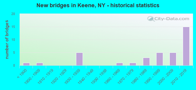
- New bridges - historical statistics
- 1Before 1900
- 11900-1909
- 51930-1939
- 11960-1969
- 11970-1979
- 31980-1989
- 51990-1999
- 52000-2009
- 152010-2019

- Reconstructed bridges - Historical Statistics
- 11990-1999
- 32000-2009
- 12010-2019


- Bridge Condition - Deck
- 38.7%Excellent
- 25.8%Very good
- 22.6%Good
- 6.5%Satisfactory
- 3.2%Fair
- 3.2%Poor

- Bridge Condition - Superstructure
- 40.6%Excellent
- 18.8%Very good
- 18.8%Good
- 6.3%Satisfactory
- 12.5%Fair
- 3.1%Poor

- Bridge Condition - Substructure
- 25.0%Excellent
- 34.4%Very good
- 15.6%Good
- 9.4%Satisfactory
- 9.4%Fair
- 3.1%Poor
- 3.1%Critical

- Bridge Condition - Channel
- 16.2%Very good
- 43.2%Good
- 18.9%Satisfactory
- 13.5%Fair
- 8.1%Poor

- Bridge Condition - Culverts
- 20.0%Very good
- 20.0%Good
- 60.0%Satisfactory
Find on map >> Show street view
Structure Number: 100698, Location: RT 73 2.8 MI N KEENE V. (Lat: 44.234561, Lng: -73.782486), Route carried "on" structure: US 9N, Year Built: 2012, Status: Open, Structure Length: 1.25m (4.10ft), Average Daily Traffic: 4,400 (year 2018), Truck Traffic: 6%, Average Future Daily Traffic: 4,929 (year 2040), Design Load: HL 93, Features Intersected: NORTON BROOK
Minimum Vertical Clearance: 30+ m (98+ ft), Kilometerpoint: 80.273, Lanes on structure: 2, Base Highway Network: Yes, Owner: State Highway Agency, Approaching Roadway Width: 9.1m (29.9ft), Skew: 3 degrees, Material/Design: Concrete, Design/Construction: Frame, Number Of Spans In Main Unit: 1, Length of Maximum Span: 12.2m (40.0ft), Curb-To-Curb Width: 9.1m (29.9ft), Out-to-Out Width: 11.6m (38.1ft)
Condition: Deck: Very good, Superstructure: Very good, Substructure: Very good, Channel: Fair, Operating Rating: 47.6 metric tons, Method Used To Determine Operating Rating: Load and Resistance Factor Rating (LRFR) rating reported by rating factor(RF) method using HL-93 loadings, Inventory Rating: 36.9 metric tons, Method Used To Determine Inventory Rating: Load and Resistance Factor Rating (LRFR) rating reported by rating factor(RF) method using HL-93 loadings, Structural Evaluation: Equal to present desirable criteria, Deck Geometry: Meets minimum limits, Waterway Adequacy: Somewhat better than minimum adequacy, Approach Roadway Alignment: Equal to present desirable criteria, Length Of Structure Improvement: 1.24m (4.07ft), Designated Inspection Frequency: Every 24 months, Inspection Date: September 2020, Bridge Improvement Cost: $614,000, Roadway Improvement Cost: $360,000, Total Project Cost: $974,000 ( Estimate for 2021), Wearing Surface/Protective System: Wearing Surface: Bituminous
Find on map >> Show street view
Structure Number: 100699, Location: JCT OF ROUTES 73 & 9N (Lat: 44.256903, Lng: -73.792150), Route carried "on" structure: State highway 9N, Year Built: 2000, Status: Open, Structure Length: 1.25m (4.10ft), Average Daily Traffic: 1,057 (year 2020), Truck Traffic: 7%, Average Future Daily Traffic: 1,184 (year 2040), Design Load: HS 25 or greater, Features Intersected: GULF BROOK
Minimum Vertical Clearance: 30+ m (98+ ft), Kilometerpoint: 83.217, Lanes on structure: 2, Base Highway Network: Yes, Owner: State Highway Agency, Approaching Roadway Width: 10.4m (34.1ft), Skew: 3 degrees, Material/Design: Concrete, Design/Construction: Frame, Number Of Spans In Main Unit: 1, Length of Maximum Span: 12.1m (39.7ft), Curb or Sidewalk Widths: Left: 0.0m, Right: 1.5m (4.9ft), Curb-To-Curb Width: 10.1m (33.1ft), Out-to-Out Width: 13.6m (44.6ft)
Condition: Deck: Very good, Superstructure: Good, Substructure: Very good, Channel: Good, Operating Rating: 80.7 metric tons, Method Used To Determine Operating Rating: Load Factor (LF), Inventory Rating: 48.1 metric tons, Method Used To Determine Inventory Rating: Load Factor (LF), Structural Evaluation: Better than present minimum criteria, Deck Geometry: Somewhat better than minimum adequacy, Waterway Adequacy: Superior to present desirable criteria, Approach Roadway Alignment: Equal to present desirable criteria, Length Of Structure Improvement: 1.24m (4.07ft), Designated Inspection Frequency: Every 24 months, Inspection Date: April 2020, Bridge Improvement Cost: $502,000, Roadway Improvement Cost: $294,000, Total Project Cost: $796,000 ( Estimate for 2021), Wearing Surface/Protective System: Wearing Surface: Bituminous, Membrane: Other
Find on map >> Show street view
Structure Number: 1007, Location: 3.0 MI N JCT RTS 9N & 73 (Lat: 44.298411, Lng: -73.786186), Route carried "on" structure: US 9N, Year Built: 1930, Status: Open, Structure Length: 1.04m (3.41ft), Average Daily Traffic: 1,057 (year 2020), Truck Traffic: 7%, Average Future Daily Traffic: 1,184 (year 2040), Features Intersected: STYLES BROOK
Minimum Vertical Clearance: 30+ m (98+ ft), Kilometerpoint: 88.028, Lanes on structure: 2, Base Highway Network: Yes, Owner: State Highway Agency, Approaching Roadway Width: 8.8m (28.9ft), Skew: 1 degrees, Material/Design: Steel, Design/Construction: Stringer/Multi-beam, Number Of Spans In Main Unit: 1, Length of Maximum Span: 9.1m (29.9ft), Curb-To-Curb Width: 9.2m (30.2ft), Out-to-Out Width: 10.2m (33.5ft)
Condition: Deck: Poor, Superstructure: Fair, Substructure: Fair, Channel: Satisfactory, Inventory Rating: 88.9 metric tons, Method Used To Determine Inventory Rating: Load Factor (LF), Structural Evaluation: Somewhat better than minimum adequacy, Deck Geometry: Somewhat better than minimum adequacy, Waterway Adequacy: High priority of corrective action, Approach Roadway Alignment: Equal to present desirable criteria, Length Of Structure Improvement: 1.03m (3.38ft), Designated Inspection Frequency: Every 24 months, Inspection Date: April 2020, Bridge Improvement Cost: $374,000, Roadway Improvement Cost: $219,000, Total Project Cost: $593,000 ( Estimate for 2021), Deck Structure Type: Concrete Cast-file-Place, Wearing Surface/Protective System: Wearing Surface: Bituminous
Find on map >> Show street view
Structure Number: 102967, Location: RT 73 0.4 MI N JCT RT9&73 (Lat: 44.104519, Lng: -73.692167), Route carried "on" structure: US 73, Year Built: 1935, Year Reconstructed: 2005, Status: Open, Structure Length: 1.01m (3.31ft), Average Daily Traffic: 3,971 (year 2018), Truck Traffic: 5%, Average Future Daily Traffic: 4,235 (year 2040), Features Intersected: SO FORK BOUQUET RIVER
Minimum Vertical Clearance: 30+ m (98+ ft), Kilometerpoint: 0.595, Lanes on structure: 2, Base Highway Network: Yes, Owner: State Highway Agency, Approaching Roadway Width: 7.9m (25.9ft), Material/Design: Steel, Design/Construction: Stringer/Multi-beam, Number Of Spans In Main Unit: 1, Length of Maximum Span: 9.4m (30.8ft), Curb-To-Curb Width: 8.0m (26.2ft), Out-to-Out Width: 8.7m (28.5ft)
Condition: Deck: Fair, Superstructure: Fair, Substructure: Satisfactory, Channel: Good, Operating Rating: 96.2 metric tons, Method Used To Determine Operating Rating: Load Factor (LF), Inventory Rating: 58.1 metric tons, Method Used To Determine Inventory Rating: Load Factor (LF), Structural Evaluation: Somewhat better than minimum adequacy, Deck Geometry: High priority of corrective action, Waterway Adequacy: Equal to present minimum criteria, Approach Roadway Alignment: Meets minimum limits, Length Of Structure Improvement: 1.00m (3.28ft), Designated Inspection Frequency: Every 24 months, Inspection Date: October 2020, Bridge Improvement Cost: $473,000, Roadway Improvement Cost: $277,000, Total Project Cost: $750,000 ( Estimate for 2021), Deck Structure Type: Concrete Cast-file-Place, Wearing Surface/Protective System: Wearing Surface: Bituminous
Find on map >> Show street view
Structure Number: 102968, Location: RT 73 1.4 MI N JCT RT9&73 (Lat: 44.113114, Lng: -73.708958), Route carried "on" structure: US 73, Year Built: 1935, Status: Open, Structure Length: 1.86m (6.10ft), Average Daily Traffic: 3,971 (year 2018), Truck Traffic: 5%, Average Future Daily Traffic: 4,235 (year 2040), Features Intersected: N. FORK BOUQUET RIVER
Minimum Vertical Clearance: 30+ m (98+ ft), Kilometerpoint: 2.269, Lanes on structure: 2, Base Highway Network: Yes, Owner: State Highway Agency, Approaching Roadway Width: 9.1m (29.9ft), Skew: 2 degrees, Material/Design: Concrete, Design/Construction: Arch - Deck, Number Of Spans In Main Unit: 1, Length of Maximum Span: 18.3m (60.0ft), Curb or Sidewalk Widths: Left: 0.3m (1.0ft), Right: 0.0m, Curb-To-Curb Width: 7.2m (23.6ft), Out-to-Out Width: 9.2m (30.2ft)
Condition: Superstructure: Fair, Substructure: Satisfactory, Channel: Good, Operating Rating: 53.4 metric tons, Method Used To Determine Operating Rating: Field evaluation and documented engineering judgment, Inventory Rating: 13.5 metric tons, Method Used To Determine Inventory Rating: Field evaluation and documented engineering judgment, Structural Evaluation: Meets minimum limits, Deck Geometry: High priority of replacement, Waterway Adequacy: Superior to present desirable criteria, Approach Roadway Alignment: Meets minimum limits, Length Of Structure Improvement: 1.85m (6.07ft), Designated Inspection Frequency: Every 24 months, Inspection Date: June 2020, Bridge Improvement Cost: $768,000, Roadway Improvement Cost: $450,000, Total Project Cost: $1,218,000 ( Estimate for 2021), Wearing Surface/Protective System: Wearing Surface: Bituminous
Find on map >> Show street view
Structure Number: 102969, Location: RT 73 3.0 MI S KEENE V. (Lat: 44.150206, Lng: -73.767597), Route carried "on" structure: US 73, Year Built: 1935, Status: Open, Structure Length: 0.88m (2.89ft), Average Daily Traffic: 3,971 (year 2018), Truck Traffic: 5%, Average Future Daily Traffic: 4,235 (year 2040), Features Intersected: BEEDE BROOK
Minimum Vertical Clearance: 30+ m (98+ ft), Kilometerpoint: 8.705, Lanes on structure: 2, Base Highway Network: Yes, Owner: State Highway Agency, Approaching Roadway Width: 9.8m (32.2ft), Skew: 4 degrees, Material/Design: Concrete, Design/Construction: Culvert, Number Of Spans In Main Unit: 1, Length of Maximum Span: 8.5m (27.9ft)
Condition: Channel: Good, Culverts: Satisfactory, Operating Rating: 67.6 metric tons, Method Used To Determine Operating Rating: Field evaluation and documented engineering judgment, Inventory Rating: 26.4 metric tons, Method Used To Determine Inventory Rating: Field evaluation and documented engineering judgment, Structural Evaluation: Equal to present minimum criteria, Waterway Adequacy: Equal to present minimum criteria, Approach Roadway Alignment: Equal to present desirable criteria, Length Of Structure Improvement: 0.88m (2.89ft), Designated Inspection Frequency: Every 24 months, Inspection Date: June 2020, Bridge Improvement Cost: $330,000, Roadway Improvement Cost: $193,000, Total Project Cost: $523,000 ( Estimate for 2021), Wearing Surface/Protective System: Wearing Surface: Bituminous
Find on map >> Show street view
Structure Number: 10297, Location: RT 73 2.8 MI S KEENE V. (Lat: 44.152625, Lng: -73.768811), Route carried "on" structure: US 73, Year Built: 1935, Status: Open, Structure Length: 0.67m (2.20ft), Average Daily Traffic: 3,971 (year 2018), Truck Traffic: 5%, Average Future Daily Traffic: 4,235 (year 2040), Features Intersected: PUTNAM BROOK
Minimum Vertical Clearance: 30+ m (98+ ft), Kilometerpoint: 8.978, Lanes on structure: 2, Base Highway Network: Yes, Owner: State Highway Agency, Approaching Roadway Width: 9.4m (30.8ft), Skew: 1 degrees, Material/Design: Concrete, Design/Construction: Culvert, Number Of Spans In Main Unit: 1, Length of Maximum Span: 6.4m (21.0ft)
Condition: Channel: Fair, Culverts: Satisfactory, Operating Rating: 42.6 metric tons, Method Used To Determine Operating Rating: Load Factor (LF), Inventory Rating: 25.4 metric tons, Method Used To Determine Inventory Rating: Load Factor (LF), Structural Evaluation: Equal to present minimum criteria, Waterway Adequacy: Superior to present desirable criteria, Approach Roadway Alignment: Equal to present desirable criteria, Length Of Structure Improvement: 0.67m (2.20ft), Designated Inspection Frequency: Every 24 months, Inspection Date: June 2020, Bridge Improvement Cost: $259,000, Roadway Improvement Cost: $152,000, Total Project Cost: $410,000 ( Estimate for 2021), Wearing Surface/Protective System: Wearing Surface: Bituminous
Find on map >> Show street view
Structure Number: 102971, Location: RT 73 2.5 MI S KEENE V. (Lat: 44.155925, Lng: -73.771156), Route carried "on" structure: US 73, Year Built: 2016, Status: Open, Structure Length: 2.26m (7.41ft), Average Daily Traffic: 3,971 (year 2018), Truck Traffic: 5%, Average Future Daily Traffic: 4,235 (year 2040), Design Load: HL 93, Features Intersected: BEEDE BROOK
Minimum Vertical Clearance: 30+ m (98+ ft), Kilometerpoint: 9.413, Lanes on structure: 2, Base Highway Network: Yes, Owner: State Highway Agency, Approaching Roadway Width: 10.4m (34.1ft), Skew: 3 degrees, Material/Design: Prestressed concrete, Design/Construction: Channel Beam, Number Of Spans In Main Unit: 1, Length of Maximum Span: 22.3m (73.2ft), Curb-To-Curb Width: 10.4m (34.1ft), Out-to-Out Width: 11.4m (37.4ft)
Condition: Deck: Excellent, Superstructure: Excellent, Substructure: Good, Channel: Satisfactory, Operating Rating: 68.9 metric tons, Method Used To Determine Operating Rating: Load Factor (LF), Inventory Rating: 27.2 metric tons, Method Used To Determine Inventory Rating: Load Factor (LF), Structural Evaluation: Equal to present minimum criteria, Deck Geometry: Somewhat better than minimum adequacy, Waterway Adequacy: Somewhat better than minimum adequacy, Approach Roadway Alignment: Equal to present minimum criteria, Length Of Structure Improvement: 2.25m (7.38ft), Designated Inspection Frequency: Every 24 months, Inspection Date: April 2020, Bridge Improvement Cost: $1,723,000, Roadway Improvement Cost: $1,009,000, Total Project Cost: $2,731,000 ( Estimate for 2021), Wearing Surface/Protective System: Wearing Surface: Latex Concrete
Find on map >> Show street view
Structure Number: 102972, Location: RT 73 2.2 MI S KEENE V. (Lat: 44.159800, Lng: -73.775067), Route carried "on" structure: US 73, Year Built: 2016, Status: Open, Structure Length: 1.65m (5.41ft), Average Daily Traffic: 3,971 (year 2018), Truck Traffic: 5%, Average Future Daily Traffic: 4,235 (year 2040), Design Load: HL 93, Features Intersected: BEEDE BROOK
Minimum Vertical Clearance: 30+ m (98+ ft), Kilometerpoint: 9.944, Lanes on structure: 2, Base Highway Network: Yes, Owner: State Highway Agency, Approaching Roadway Width: 10.4m (34.1ft), Skew: 3 degrees, Material/Design: Prestressed concrete, Design/Construction: Channel Beam, Number Of Spans In Main Unit: 1, Length of Maximum Span: 16.2m (53.1ft), Curb-To-Curb Width: 10.4m (34.1ft), Out-to-Out Width: 11.4m (37.4ft)
Condition: Deck: Excellent, Superstructure: Excellent, Substructure: Poor, Channel: Poor, Operating Rating: 66.2 metric tons, Method Used To Determine Operating Rating: Load Factor (LF), Inventory Rating: 29.9 metric tons, Method Used To Determine Inventory Rating: Load Factor (LF), Structural Evaluation: Meets minimum limits, Deck Geometry: Somewhat better than minimum adequacy, Waterway Adequacy: Meets minimum limits, Approach Roadway Alignment: Equal to present minimum criteria, Length Of Structure Improvement: 1.64m (5.38ft), Designated Inspection Frequency: Every 24 months, Inspection Date: April 2020, Bridge Improvement Cost: $1,273,000, Roadway Improvement Cost: $746,000, Total Project Cost: $2,019,000 ( Estimate for 2021), Wearing Surface/Protective System: Wearing Surface: Latex Concrete
Find on map >> Show street view
Structure Number: 102973, Location: 1.9 MI S OF KEENE VALLEY (Lat: 44.163472, Lng: -73.778358), Route carried "on" structure: State highway 73, Year Built: 2016, Status: Open, Structure Length: 3.26m (10.70ft), Average Daily Traffic: 3,971 (year 2018), Truck Traffic: 5%, Average Future Daily Traffic: 4,235 (year 2040), Design Load: HL 93, Features Intersected: E BR AUSABLE RVR
Minimum Vertical Clearance: 30+ m (98+ ft), Kilometerpoint: 10.426, Lanes on structure: 2, Base Highway Network: Yes, Owner: State Highway Agency, Approaching Roadway Width: 10.7m (35.1ft), Skew: 3 degrees, Material/Design: Steel, Design/Construction: Stringer/Multi-beam, Number Of Spans In Main Unit: 1, Length of Maximum Span: 32.0m (105.0ft), Curb-To-Curb Width: 10.4m (34.1ft), Out-to-Out Width: 11.4m (37.4ft)
Condition: Deck: Excellent, Superstructure: Excellent, Substructure: Excellent, Channel: Good, Operating Rating: 94.3 metric tons, Method Used To Determine Operating Rating: Load Factor (LF), Inventory Rating: 56.2 metric tons, Method Used To Determine Inventory Rating: Load Factor (LF), Structural Evaluation: Superior to present desirable criteria, Deck Geometry: Somewhat better than minimum adequacy, Waterway Adequacy: Equal to present minimum criteria, Approach Roadway Alignment: Equal to present desirable criteria, Length Of Structure Improvement: 3.26m (10.70ft), Designated Inspection Frequency: Every 24 months, Inspection Date: August 2020, Bridge Improvement Cost: $998,000, Roadway Improvement Cost: $584,000, Total Project Cost: $1,582,000 ( Estimate for 2021), Deck Structure Type: Concrete Cast-file-Place, Wearing Surface/Protective System: Wearing Surface: Integral Concrete, Deck Protection: Epoxy Coated Reinforcing
Find on map >> Show street view
Structure Number: 102974, Location: N END KEENE VALLEY (Lat: 44.194253, Lng: -73.786625), Route carried "on" structure: US 73, Year Built: 2016, Status: Open, Structure Length: 4.24m (13.91ft), Average Daily Traffic: 3,971 (year 2018), Truck Traffic: 5%, Average Future Daily Traffic: 4,235 (year 2040), Design Load: HL 93, Features Intersected: JOHNS BROOK
Minimum Vertical Clearance: 30+ m (98+ ft), Kilometerpoint: 13.998, Lanes on structure: 2, Base Highway Network: Yes, Owner: State Highway Agency, Approaching Roadway Width: 9.1m (29.9ft), Skew: 4 degrees, Material/Design: Steel, Design/Construction: Stringer/Multi-beam, Number Of Spans In Main Unit: 1, Length of Maximum Span: 42.1m (138.1ft), Curb or Sidewalk Widths: Left: 1.5m (4.9ft), Right: 1.5m (4.9ft), Curb-To-Curb Width: 9.1m (29.9ft), Out-to-Out Width: 13.5m (44.3ft)
Condition: Deck: Excellent, Superstructure: Excellent, Substructure: Very good, Channel: Very good, Operating Rating: 87.1 metric tons, Method Used To Determine Operating Rating: Load Factor (LF), Inventory Rating: 51.7 metric tons, Method Used To Determine Inventory Rating: Load Factor (LF), Structural Evaluation: Equal to present desirable criteria, Deck Geometry: Meets minimum limits, Waterway Adequacy: Equal to present desirable criteria, Approach Roadway Alignment: Equal to present desirable criteria, Length Of Structure Improvement: 4.23m (13.88ft), Designated Inspection Frequency: Every 24 months, Inspection Date: April 2020, Bridge Improvement Cost: $1,376,000, Roadway Improvement Cost: $806,000, Total Project Cost: $2,182,000 ( Estimate for 2021), Deck Structure Type: Concrete Cast-file-Place, Wearing Surface/Protective System: Wearing Surface: Integral Concrete, Deck Protection: Epoxy Coated Reinforcing
Find on map >> Show street view
Structure Number: 102975, Location: RT 73 0.1 MI N KEENE V. (Lat: 44.195503, Lng: -73.786569), Route carried "on" structure: US 73, Year Built: 2015, Status: Open, Structure Length: 1.07m (3.51ft), Average Daily Traffic: 3,971 (year 2018), Truck Traffic: 5%, Average Future Daily Traffic: 4,235 (year 2040), Design Load: HL 93, Features Intersected: JOHNS BR OVERFLOW
Minimum Vertical Clearance: 30+ m (98+ ft), Kilometerpoint: 14.127, Lanes on structure: 2, Base Highway Network: Yes, Owner: State Highway Agency, Approaching Roadway Width: 9.1m (29.9ft), Skew: 2 degrees, Material/Design: Concrete, Design/Construction: Frame, Number Of Spans In Main Unit: 1, Length of Maximum Span: 9.1m (29.9ft), Curb or Sidewalk Widths: Left: 1.6m (5.2ft), Right: 1.6m (5.2ft), Curb-To-Curb Width: 9.1m (29.9ft), Out-to-Out Width: 13.6m (44.6ft)
Condition: Deck: Excellent, Superstructure: Excellent, Substructure: Excellent, Channel: Fair, Operating Rating: 79.1 metric tons, Method Used To Determine Operating Rating: Field evaluation and documented engineering judgment, Inventory Rating: 40.8 metric tons, Method Used To Determine Inventory Rating: Field evaluation and documented engineering judgment, Structural Evaluation: Superior to present desirable criteria, Deck Geometry: Meets minimum limits, Waterway Adequacy: Equal to present minimum criteria, Approach Roadway Alignment: Equal to present desirable criteria, Length Of Structure Improvement: 1.06m (3.48ft), Designated Inspection Frequency: Every 24 months, Inspection Date: May 2021, Bridge Improvement Cost: $448,000, Roadway Improvement Cost: $262,000, Total Project Cost: $710,000 ( Estimate for 2021), Wearing Surface/Protective System: Wearing Surface: Bituminous, Membrane: Preformed Fabric
Find on map >> Show street view
Structure Number: 102976, Location: RT 73 2.2 MI N KEENE V. (Lat: 44.226886, Lng: -73.784719), Route carried "on" structure: US 73, Year Built: 2016, Status: Open, Structure Length: 3.57m (11.71ft), Average Daily Traffic: 3,971 (year 2018), Truck Traffic: 5%, Average Future Daily Traffic: 4,235 (year 2040), Design Load: HL 93, Features Intersected: E BRANCH AUSABLE RIVER
Minimum Vertical Clearance: 30+ m (98+ ft), Kilometerpoint: 17.683, Lanes on structure: 2, Base Highway Network: Yes, Owner: State Highway Agency, Approaching Roadway Width: 10.4m (34.1ft), Material/Design: Steel, Design/Construction: Stringer/Multi-beam, Number Of Spans In Main Unit: 1, Length of Maximum Span: 35.1m (115.2ft), Curb-To-Curb Width: 10.4m (34.1ft), Out-to-Out Width: 11.4m (37.4ft)
Condition: Deck: Excellent, Superstructure: Excellent, Substructure: Excellent, Channel: Good, Inventory Rating: 62.6 metric tons, Method Used To Determine Inventory Rating: Load Factor (LF), Structural Evaluation: Superior to present desirable criteria, Deck Geometry: Somewhat better than minimum adequacy, Waterway Adequacy: Equal to present desirable criteria, Approach Roadway Alignment: Equal to present desirable criteria, Length Of Structure Improvement: 3.56m (11.68ft), Designated Inspection Frequency: Every 24 months, Inspection Date: June 2020, Bridge Improvement Cost: $933,000, Roadway Improvement Cost: $546,000, Total Project Cost: $1,479,000 ( Estimate for 2021), Deck Structure Type: Concrete Cast-file-Place, Wearing Surface/Protective System: Wearing Surface: Integral Concrete, Deck Protection: Epoxy Coated Reinforcing
Find on map >> Show street view
Structure Number: 102978, Location: 0.7 MI NW JCT RTS 73 & 9N (Lat: 44.263667, Lng: -73.798822), Route carried "on" structure: US 73, Year Built: 2016, Status: Open, Structure Length: 1.04m (3.41ft), Average Daily Traffic: 3,200 (year 2014), Truck Traffic: 7%, Average Future Daily Traffic: 3,412 (year 2040), Design Load: HL 93, Features Intersected: CASCADE LK OUTLET
Minimum Vertical Clearance: 30+ m (98+ ft), Kilometerpoint: 22.462, Lanes on structure: 2, Base Highway Network: Yes, Owner: State Highway Agency, Approaching Roadway Width: 10.4m (34.1ft), Skew: 1 degrees, Material/Design: Concrete, Design/Construction: Frame, Number Of Spans In Main Unit: 1, Length of Maximum Span: 10.1m (33.1ft), Curb-To-Curb Width: 10.4m (34.1ft), Out-to-Out Width: 11.4m (37.4ft)
Condition: Deck: Excellent, Superstructure: Excellent, Substructure: Very good, Channel: Good, Operating Rating: 79.7 metric tons, Method Used To Determine Operating Rating: Field evaluation and documented engineering judgment, Inventory Rating: 40.8 metric tons, Method Used To Determine Inventory Rating: Field evaluation and documented engineering judgment, Structural Evaluation: Equal to present desirable criteria, Deck Geometry: Somewhat better than minimum adequacy, Waterway Adequacy: Superior to present desirable criteria, Approach Roadway Alignment: Equal to present desirable criteria, Length Of Structure Improvement: 1.03m (3.38ft), Designated Inspection Frequency: Every 24 months, Inspection Date: September 2020, Bridge Improvement Cost: $435,000, Roadway Improvement Cost: $255,000, Total Project Cost: $690,000 ( Estimate for 2021), Wearing Surface/Protective System: Wearing Surface: Bituminous
Find on map >> Show street view
Structure Number: 106024, Location: .1 MI NW JCT SH 9N & SH73 (Lat: 44.256811, Lng: -73.793739), Route carried "on" structure: State highway 73, Year Built: 1993, Year Reconstructed: 2015, Status: Open, Structure Length: 3.35m (10.99ft), Average Daily Traffic: 3,200 (year 2014), Truck Traffic: 7%, Average Future Daily Traffic: 3,412 (year 2040), Design Load: HL 93, Features Intersected: E BR AUSABLE RVR
Minimum Vertical Clearance: 30+ m (98+ ft), Kilometerpoint: 21.577, Lanes on structure: 2, Base Highway Network: Yes, Owner: State Highway Agency, Approaching Roadway Width: 9.8m (32.2ft), Material/Design: Prestressed concrete, Design/Construction: Box Beam or Girders - Multiple, Number Of Spans In Main Unit: 1, Length of Maximum Span: 32.6m (107.0ft), Curb or Sidewalk Widths: Left: 0.0m, Right: 1.6m (5.2ft), Curb-To-Curb Width: 9.8m (32.2ft), Out-to-Out Width: 12.5m (41.0ft)
Condition: Deck: Good, Superstructure: Very good, Substructure: Very good, Channel: Good, Inventory Rating: 49.9 metric tons, Method Used To Determine Inventory Rating: Load Factor (LF), Structural Evaluation: Equal to present desirable criteria, Deck Geometry: Meets minimum limits, Waterway Adequacy: Equal to present minimum criteria, Approach Roadway Alignment: Equal to present desirable criteria, Length Of Structure Improvement: 3.35m (10.99ft), Designated Inspection Frequency: Every 24 months, Inspection Date: August 2021, Bridge Improvement Cost: $1,506,000, Roadway Improvement Cost: $882,000, Total Project Cost: $2,387,000 ( Estimate for 2021), Wearing Surface/Protective System: Wearing Surface: Monolithic Concrete
Find on map >> Show street view
Structure Number: 225987, Location: 1 MI W OF KEENE VALLEY (Lat: 44.190625, Lng: -73.799392), Route carried "on" structure: Other road , Year Built: 1985, Status: Posted for load-capacity, Structure Length: 0.67m (2.20ft), Truck Traffic: 10%, Features Intersected: SLIDE BROOK, Facility Carried by Structure: STOVER ROAD
Minimum Vertical Clearance: 30+ m (98+ ft), Kilometerpoint: 0.080, Lanes on structure: 2, Owner: County Highway Agency, Approaching Roadway Width: 5.8m (19.0ft), Skew: 2 degrees, Material/Design: Steel, Design/Construction: Culvert, Number Of Spans In Main Unit: 1, Length of Maximum Span: 6.4m (21.0ft)
Condition: Channel: Fair, Culverts: Satisfactory, Operating Rating: 76.7 metric tons, Method Used To Determine Operating Rating: Field evaluation and documented engineering judgment, Inventory Rating: 29.4 metric tons, Method Used To Determine Inventory Rating: Field evaluation and documented engineering judgment, Structural Evaluation: Equal to present minimum criteria, Waterway Adequacy: Equal to present desirable criteria, Approach Roadway Alignment: Somewhat better than minimum adequacy, Length Of Structure Improvement: 0.67m (2.20ft), Designated Inspection Frequency: Every 24 months, Inspection Date: April 2020, Bridge Improvement Cost: $68,000, Roadway Improvement Cost: $40,000, Total Project Cost: $108,000 ( Estimate for 2021)
Find on map >> Show street view
Structure Number: 33023, Location: 1.5 MI E OF KEENE (Lat: 44.254889, Lng: -73.742808), Route carried "on" structure: County highway , Year Built: 1998, Status: Open, Structure Length: 0.91m (2.99ft), Average Daily Traffic: 72 (year 2017), Truck Traffic: 6%, Average Future Daily Traffic: 101 (year 2037), Design Load: HS 20, Features Intersected: GULF BROOK, Facility Carried by Structure: CR 13, HURRICANE R
Minimum Vertical Clearance: 30+ m (98+ ft), Kilometerpoint: 5.648, Lanes on structure: 2, Owner: County Highway Agency, Approaching Roadway Width: 7.6m (24.9ft), Skew: 3 degrees, Material/Design: Steel, Design/Construction: Stringer/Multi-beam, Number Of Spans In Main Unit: 1, Length of Maximum Span: 8.2m (26.9ft), Curb-To-Curb Width: 7.7m (25.3ft), Out-to-Out Width: 8.3m (27.2ft)
Condition: Deck: Good, Superstructure: Fair, Substructure: Very good, Channel: Satisfactory, Operating Rating: 90.1 metric tons, Method Used To Determine Operating Rating: Load and Resistance Factor Rating (LRFR) rating reported by rating factor(RF) method using HL-93 loadings, Inventory Rating: 69.7 metric tons, Method Used To Determine Inventory Rating: Load and Resistance Factor Rating (LRFR) rating reported by rating factor(RF) method using HL-93 loadings, Structural Evaluation: Somewhat better than minimum adequacy, Deck Geometry: Equal to present minimum criteria, Waterway Adequacy: Superior to present desirable criteria, Approach Roadway Alignment: Equal to present minimum criteria, Length Of Structure Improvement: 0.91m (2.99ft), Designated Inspection Frequency: Every 24 months, Inspection Date: May 2021, Bridge Improvement Cost: $538,000, Roadway Improvement Cost: $315,000, Total Project Cost: $853,000 ( Estimate for 2021), Deck Structure Type: Concrete Cast-file-Place, Wearing Surface/Protective System: Wearing Surface: Bituminous, Deck Protection: Epoxy Coated Reinforcing
Find on map >> Show street view
Structure Number: 330231, Location: 1 MILE EAST OF KEENE (Lat: 44.257778, Lng: -73.780939), Route carried "on" structure: County highway , Year Built: 2001, Status: Open, Structure Length: 1.40m (4.59ft), Average Daily Traffic: 72 (year 2017), Truck Traffic: 6%, Average Future Daily Traffic: 101 (year 2037), Design Load: HS 25 or greater, Features Intersected: GULF BROOK, Facility Carried by Structure: CR 13, HURRICANE R
Minimum Vertical Clearance: 30+ m (98+ ft), Kilometerpoint: 9.043, Lanes on structure: 2, Owner: County Highway Agency, Approaching Roadway Width: 7.0m (23.0ft), Skew: 3 degrees, Material/Design: Concrete, Design/Construction: Frame, Number Of Spans In Main Unit: 1, Length of Maximum Span: 12.8m (42.0ft), Curb-To-Curb Width: 7.1m (23.3ft), Out-to-Out Width: 7.7m (25.3ft)
Condition: Deck: Very good, Superstructure: Good, Substructure: Very good, Channel: Satisfactory, Operating Rating: 81.0 metric tons, Method Used To Determine Operating Rating: Load and Resistance Factor Rating (LRFR) rating reported by rating factor(RF) method using HL-93 loadings, Inventory Rating: 64.8 metric tons, Method Used To Determine Inventory Rating: Load and Resistance Factor Rating (LRFR) rating reported by rating factor(RF) method using HL-93 loadings, Structural Evaluation: Better than present minimum criteria, Deck Geometry: Somewhat better than minimum adequacy, Waterway Adequacy: Superior to present desirable criteria, Approach Roadway Alignment: Equal to present desirable criteria, Length Of Structure Improvement: 1.40m (4.59ft), Designated Inspection Frequency: Every 24 months, Inspection Date: May 2021, Bridge Improvement Cost: $353,000, Roadway Improvement Cost: $207,000, Total Project Cost: $560,000 ( Estimate for 2021)
Find on map >> Show street view
Structure Number: 330232, Location: VILLAGE OF KEENE (Lat: 44.255672, Lng: -73.790744), Route carried "on" structure: Other road , Year Built: 1997, Status: Open, Structure Length: 0.82m (2.69ft), Truck Traffic: 6%, Features Intersected: GULF BROOK, Facility Carried by Structure: BUCKS LANE
Minimum Vertical Clearance: 30+ m (98+ ft), Kilometerpoint: 0.032, Lanes on structure: 1, Owner: County Highway Agency, Approaching Roadway Width: 4.3m (14.1ft), Material/Design: Concrete, Design/Construction: Frame, Number Of Spans In Main Unit: 1, Length of Maximum Span: 7.6m (24.9ft), Curb-To-Curb Width: 4.4m (14.4ft), Out-to-Out Width: 5.2m (17.1ft)
Condition: Deck: Good, Superstructure: Good, Substructure: Very good, Channel: Good, Inventory Rating: 65.3 metric tons, Method Used To Determine Inventory Rating: Load Factor (LF), Structural Evaluation: Better than present minimum criteria, Deck Geometry: Equal to present minimum criteria, Waterway Adequacy: Superior to present desirable criteria, Approach Roadway Alignment: High priority of corrective action, Length Of Structure Improvement: 0.82m (2.69ft), Designated Inspection Frequency: Every 24 months, Inspection Date: April 2020, Bridge Improvement Cost: $154,000, Roadway Improvement Cost: $90,000, Total Project Cost: $244,000 ( Estimate for 2021), Wearing Surface/Protective System: Wearing Surface: Bituminous
Find on map >> Show street view
Structure Number: 330233, Location: 2 MI NW KEENE (Lat: 44.275247, Lng: -73.816353), Route carried "on" structure: Other road , Year Built: 2015, Status: Open, Structure Length: 2.59m (8.50ft), Average Daily Traffic: 54 (year 2016), Truck Traffic: 6%, Average Future Daily Traffic: 76 (year 2036), Design Load: HL 93, Features Intersected: CLIFFORD BROOK, Facility Carried by Structure: BARTLETT ROAD
Minimum Vertical Clearance: 30+ m (98+ ft), Kilometerpoint: 0.306, Lanes on structure: 2, Owner: County Highway Agency, Approaching Roadway Width: 5.2m (17.1ft), Material/Design: Steel, Design/Construction: Truss - Thru, Number Of Spans In Main Unit: 1, Length of Maximum Span: 24.4m (80.1ft), Curb-To-Curb Width: 5.2m (17.1ft), Out-to-Out Width: 6.9m (22.6ft)
Condition: Deck: Very good, Superstructure: Excellent, Substructure: Excellent, Channel: Very good, Operating Rating: 90.0 metric tons, Method Used To Determine Operating Rating: Field evaluation and documented engineering judgment, Inventory Rating: 40.8 metric tons, Method Used To Determine Inventory Rating: Field evaluation and documented engineering judgment, Structural Evaluation: Superior to present desirable criteria, Deck Geometry: High priority of corrective action, Waterway Adequacy: Superior to present desirable criteria, Approach Roadway Alignment: Somewhat better than minimum adequacy, Length Of Structure Improvement: 2.59m (8.50ft), Designated Inspection Frequency: Every 24 months, Critical Feature Inspection Frequency: Every 24 months, Inspection Date: May 2021, Critical Feature Inspection Date: May 2021, Bridge Improvement Cost: $1,434,000, Roadway Improvement Cost: $840,000, Total Project Cost: $2,273,000 ( Estimate for 2021), Deck Structure Type: Steel plate, Wearing Surface/Protective System: Wearing Surface: Other
Find on map >> Show street view
Structure Number: 330234, Location: 2.5 M N OF KEENE (Lat: 44.282739, Lng: -73.792561), Route carried "on" structure: Other road , Year Built: 2012, Status: Open, Structure Length: 1.77m (5.81ft), Average Daily Traffic: 101 (year 2017), Truck Traffic: 6%, Average Future Daily Traffic: 141 (year 2037), Features Intersected: CLIFFORD BROOK, Facility Carried by Structure: LACY ROAD
Minimum Vertical Clearance: 30+ m (98+ ft), Kilometerpoint: 2.912, Lanes on structure: 1, Owner: County Highway Agency, Approaching Roadway Width: 4.6m (15.1ft), Material/Design: Steel, Design/Construction: Stringer/Multi-beam, Number Of Spans In Main Unit: 1, Length of Maximum Span: 16.5m (54.1ft), Curb-To-Curb Width: 4.6m (15.1ft), Out-to-Out Width: 5.4m (17.7ft)
Condition: Deck: Very good, Superstructure: Good, Substructure: Excellent, Channel: Very good, Operating Rating: 84.3 metric tons, Method Used To Determine Operating Rating: Field evaluation and documented engineering judgment, Inventory Rating: 40.8 metric tons, Method Used To Determine Inventory Rating: Field evaluation and documented engineering judgment, Structural Evaluation: Better than present minimum criteria, Deck Geometry: High priority of replacement, Waterway Adequacy: Superior to present desirable criteria, Approach Roadway Alignment: Somewhat better than minimum adequacy, Length Of Structure Improvement: 1.76m (5.77ft), Designated Inspection Frequency: Every 24 months, Inspection Date: August 2020, Bridge Improvement Cost: $256,000, Roadway Improvement Cost: $150,000, Total Project Cost: $406,000 ( Estimate for 2021), Deck Structure Type: Other, Wearing Surface/Protective System: Wearing Surface: Bituminous, Membrane: Preformed Fabric
Find on map >> Show street view
Structure Number: 330235, Location: 2 MILES N OF VIL OF KEENE (Lat: 44.279103, Lng: -73.790481), Route carried "on" structure: Other road , Year Built: 1895, Year Reconstructed: 2006, Status: Posted for load-capacity, Structure Length: 3.78m (12.40ft), Average Daily Traffic: 101 (year 2017), Truck Traffic: 6%, Average Future Daily Traffic: 141 (year 2037), Design Load: HS 20, Features Intersected: E B AUSABLE RIVER, Facility Carried by Structure: LACY ROAD
Minimum Vertical Clearance: 30+ m (98+ ft), Kilometerpoint: 3.395, Lanes on structure: 1, Owner: County Highway Agency, Approaching Roadway Width: 4.9m (16.1ft), Material/Design: Steel, Design/Construction: Truss - Thru, Number Of Spans In Main Unit: 1, Length of Maximum Span: 37.1m (121.7ft), Curb-To-Curb Width: 4.1m (13.5ft), Out-to-Out Width: 4.7m (15.4ft)
Condition: Deck: Very good, Superstructure: Satisfactory, Substructure: Fair, Channel: Satisfactory, Operating Rating: 32.4 metric tons, Method Used To Determine Operating Rating: Load and Resistance Factor Rating (LRFR) rating reported by rating factor(RF) method using HL-93 loadings, Inventory Rating: 24.9 metric tons, Method Used To Determine Inventory Rating: Load and Resistance Factor Rating (LRFR) rating reported by rating factor(RF) method using HL-93 loadings, Structural Evaluation: Somewhat better than minimum adequacy, Deck Geometry: High priority of replacement, Waterway Adequacy: Equal to present desirable criteria, Approach Roadway Alignment: High priority of corrective action, Length Of Structure Improvement: 3.77m (12.37ft), Designated Inspection Frequency: Every 24 months, Critical Feature Inspection Frequency: Every 12 months, Inspection Date: September 2021, Critical Feature Inspection Date: September 2021, Bridge Improvement Cost: $1,155,000, Roadway Improvement Cost: $676,000, Total Project Cost: $1,831,000 ( Estimate for 2021), Deck Structure Type: Wood or Timber, Wearing Surface/Protective System: Wearing Surface: Bituminous, Membrane: Other
Find on map >> Show street view
Structure Number: 330236, Location: 2 MILES SOUTH OF KEENE (Lat: 44.233981, Lng: -73.779847), Route carried "on" structure: Other road , Year Built: 2014, Status: Open, Structure Length: 1.34m (4.40ft), Average Daily Traffic: 49 (year 2016), Truck Traffic: 6%, Average Future Daily Traffic: 69 (year 2036), Design Load: HL 93, Features Intersected: SCHAFFER BROOK, Facility Carried by Structure: CEMETERY ROAD
Minimum Vertical Clearance: 30+ m (98+ ft), Kilometerpoint: 0.080, Lanes on structure: 1, Owner: County Highway Agency, Approaching Roadway Width: 4.9m (16.1ft), Material/Design: Steel, Design/Construction: Stringer/Multi-beam, Number Of Spans In Main Unit: 1, Length of Maximum Span: 13.1m (43.0ft), Curb-To-Curb Width: 4.3m (14.1ft), Out-to-Out Width: 4.3m (14.1ft)
Condition: Deck: Excellent, Superstructure: Excellent, Substructure: Very good, Channel: Satisfactory, Operating Rating: 90.7 metric tons, Method Used To Determine Operating Rating: Load Factor (LF), Inventory Rating: 53.5 metric tons, Method Used To Determine Inventory Rating: Load Factor (LF), Structural Evaluation: Equal to present desirable criteria, Deck Geometry: Equal to present minimum criteria, Waterway Adequacy: Equal to present minimum criteria, Approach Roadway Alignment: Better than present minimum criteria, Length Of Structure Improvement: 1.34m (4.40ft), Designated Inspection Frequency: Every 24 months, Inspection Date: September 2020, Bridge Improvement Cost: $240,000, Roadway Improvement Cost: $140,000, Total Project Cost: $380,000 ( Estimate for 2021), Deck Structure Type: Corrugated Steel, Wearing Surface/Protective System: Wearing Surface: Bituminous
Find on map >> Show street view
Structure Number: 330238, Location: 4 MI NE OF KEENE (Lat: 44.296628, Lng: -73.749853), Route carried "on" structure: Other road , Year Built: 2012, Status: Open, Structure Length: 2.16m (7.09ft), Average Daily Traffic: 1 (year 2016), Truck Traffic: 6%, Average Future Daily Traffic: 1 (year 2036), Features Intersected: STYLES BROOK, Facility Carried by Structure: OCONNELL ROAD
Minimum Vertical Clearance: 30+ m (98+ ft), Kilometerpoint: 0.129, Lanes on structure: 1, Owner: County Highway Agency, Approaching Roadway Width: 4.3m (14.1ft), Material/Design: Steel, Design/Construction: Truss - Thru, Number Of Spans In Main Unit: 1, Length of Maximum Span: 21.3m (69.9ft), Curb-To-Curb Width: 4.3m (14.1ft), Out-to-Out Width: 5.0m (16.4ft)
Condition: Deck: Very good, Superstructure: Very good, Substructure: Good, Channel: Good, Operating Rating: 87.8 metric tons, Method Used To Determine Operating Rating: Field evaluation and documented engineering judgment, Inventory Rating: 40.8 metric tons, Method Used To Determine Inventory Rating: Field evaluation and documented engineering judgment, Structural Evaluation: Better than present minimum criteria, Deck Geometry: Equal to present minimum criteria, Waterway Adequacy: Superior to present desirable criteria, Approach Roadway Alignment: Equal to present minimum criteria, Length Of Structure Improvement: 2.16m (7.09ft), Designated Inspection Frequency: Every 24 months, Critical Feature Inspection Frequency: Every 24 months, Inspection Date: September 2021, Critical Feature Inspection Date: September 2021, Bridge Improvement Cost: $713,000, Roadway Improvement Cost: $417,000, Total Project Cost: $1,130,000 ( Estimate for 2021), Deck Structure Type: Steel plate, Wearing Surface/Protective System: Wearing Surface: Other
Find on map >> Show street view
Structure Number: 330239, Location: 4 MI NE KEENE (Lat: 44.299806, Lng: -73.730239), Route carried "on" structure: Other road , Year Built: 1985, Status: Open, Structure Length: 0.98m (3.22ft), Average Daily Traffic: 3 (year 2016), Truck Traffic: 6%, Average Future Daily Traffic: 4 (year 2036), Features Intersected: STYLES BROOK, Facility Carried by Structure: MACDONALD ROAD
Minimum Vertical Clearance: 30+ m (98+ ft), Kilometerpoint: 0.097, Lanes on structure: 2, Owner: County Highway Agency, Approaching Roadway Width: 6.4m (21.0ft), Material/Design: Steel, Design/Construction: Culvert, Number Of Spans In Main Unit: 2, Length of Maximum Span: 4.2m (13.8ft)
Condition: Channel: Fair, Culverts: Good, Operating Rating: 75.6 metric tons, Method Used To Determine Operating Rating: Field evaluation and documented engineering judgment, Inventory Rating: 32.7 metric tons, Method Used To Determine Inventory Rating: Field evaluation and documented engineering judgment, Structural Evaluation: Better than present minimum criteria, Waterway Adequacy: Meets minimum limits, Approach Roadway Alignment: Somewhat better than minimum adequacy, Length Of Structure Improvement: 0.97m (3.18ft), Designated Inspection Frequency: Every 24 months, Inspection Date: May 2020, Bridge Improvement Cost: $110,000, Roadway Improvement Cost: $64,000, Total Project Cost: $174,000 ( Estimate for 2021)
Find on map >> Show street view
Structure Number: 33024, Location: 0.5 MI NE OF KEENE VALLEY (Lat: 44.199819, Lng: -73.782803), Route carried "on" structure: County highway , Year Built: 1980, Status: Open, Structure Length: 5.58m (18.31ft), Average Daily Traffic: 340 (year 2017), Truck Traffic: 6%, Average Future Daily Traffic: 476 (year 2037), Design Load: H 20, Features Intersected: EAST BRANCH AUSABLE R, Facility Carried by Structure: BEEDE LANE
Minimum Vertical Clearance: 30+ m (98+ ft), Kilometerpoint: 0.257, Lanes on structure: 2, Owner: County Highway Agency, Approaching Roadway Width: 7.9m (25.9ft), Material/Design: Prestressed concrete, Design/Construction: Box Beam or Girders - Multiple, Number Of Spans In Main Unit: 2, Length of Maximum Span: 27.4m (89.9ft), Curb-To-Curb Width: 7.9m (25.9ft), Out-to-Out Width: 8.7m (28.5ft)
Condition: Deck: Good, Superstructure: Very good, Substructure: Good, Channel: Satisfactory, Operating Rating: 97.1 metric tons, Method Used To Determine Operating Rating: Load Factor (LF), Inventory Rating: 58.1 metric tons, Method Used To Determine Inventory Rating: Load Factor (LF), Structural Evaluation: Better than present minimum criteria, Deck Geometry: Somewhat better than minimum adequacy, Waterway Adequacy: Superior to present desirable criteria, Approach Roadway Alignment: Meets minimum limits, Length Of Structure Improvement: 5.57m (18.27ft), Designated Inspection Frequency: Every 24 months, Inspection Date: April 2020, Bridge Improvement Cost: $1,441,000, Roadway Improvement Cost: $844,000, Total Project Cost: $2,284,000 ( Estimate for 2021), Wearing Surface/Protective System: Wearing Surface: Bituminous
Find on map >> Show street view
Structure Number: 330241, Location: 0.8 MI NE KEENE VALLEY (Lat: 44.199844, Lng: -73.780200), Route carried "on" structure: Other road , Year Built: 2000, Status: Posted for load-capacity, Structure Length: 1.16m (3.81ft), Average Daily Traffic: 340 (year 2017), Truck Traffic: 6%, Average Future Daily Traffic: 476 (year 2037), Design Load: HS 20, Features Intersected: PHELPS BROOK, Facility Carried by Structure: BEEDE ROAD
Minimum Vertical Clearance: 30+ m (98+ ft), Kilometerpoint: 0.499, Lanes on structure: 2, Owner: County Highway Agency, Approaching Roadway Width: 6.7m (22.0ft), Skew: 4 degrees, Material/Design: Wood or Timber, Design/Construction: Slab, Number Of Spans In Main Unit: 1, Length of Maximum Span: 10.6m (34.8ft), Curb-To-Curb Width: 6.7m (22.0ft), Out-to-Out Width: 7.1m (23.3ft)
Condition: Deck: Very good, Superstructure: Very good, Substructure: Very good, Channel: Good, Operating Rating: 39.0 metric tons, Method Used To Determine Operating Rating: Load Factor (LF), Inventory Rating: 23.6 metric tons, Method Used To Determine Inventory Rating: Load Factor (LF), Structural Evaluation: Equal to present minimum criteria, Deck Geometry: Meets minimum limits, Waterway Adequacy: Superior to present desirable criteria, Approach Roadway Alignment: Somewhat better than minimum adequacy, Length Of Structure Improvement: 1.15m (3.77ft), Designated Inspection Frequency: Every 24 months, Inspection Date: August 2020, Bridge Improvement Cost: $350,000, Roadway Improvement Cost: $205,000, Total Project Cost: $555,000 ( Estimate for 2021), Deck Structure Type: Wood or Timber, Wearing Surface/Protective System: Wearing Surface: Bituminous
Find on map >> Show street view
Structure Number: 330242, Location: VILLAGE OF KEENE VALLEY (Lat: 44.194333, Lng: -73.785764), Route carried "on" structure: Other road , Year Built: 1900, Year Reconstructed: 1998, Status: Open, Structure Length: 2.77m (9.09ft), Truck Traffic: 10%, Design Load: HS 20, Features Intersected: E BR AUSABLE RIVER, Facility Carried by Structure: LAIGHT HALL ROAD
Minimum Vertical Clearance: 30+ m (98+ ft), Kilometerpoint: 0.048, Lanes on structure: 1, Owner: County Highway Agency, Approaching Roadway Width: 4.3m (14.1ft), Material/Design: Steel, Design/Construction: Truss - Thru, Number Of Spans In Main Unit: 1, Length of Maximum Span: 26.5m (86.9ft), Curb-To-Curb Width: 4.2m (13.8ft), Out-to-Out Width: 4.6m (15.1ft)
Condition: Deck: Good, Superstructure: Good, Substructure: Fair, Channel: Good, Operating Rating: 19.4 metric tons, Method Used To Determine Operating Rating: Load and Resistance Factor Rating (LRFR) rating reported by rating factor(RF) method using HL-93 loadings, Inventory Rating: 14.9 metric tons, Method Used To Determine Inventory Rating: Load and Resistance Factor Rating (LRFR) rating reported by rating factor(RF) method using HL-93 loadings, Structural Evaluation: Meets minimum limits, Deck Geometry: Somewhat better than minimum adequacy, Waterway Adequacy: Somewhat better than minimum adequacy, Approach Roadway Alignment: Somewhat better than minimum adequacy, Length Of Structure Improvement: 2.77m (9.09ft), Designated Inspection Frequency: Every 24 months, Critical Feature Inspection Frequency: Every 24 months, Inspection Date: May 2020, Critical Feature Inspection Date: May 2020, Bridge Improvement Cost: $964,000, Roadway Improvement Cost: $564,000, Total Project Cost: $1,528,000 ( Estimate for 2021), Deck Structure Type: Wood or Timber, Wearing Surface/Protective System: Wearing Surface: Wood or Timber
Find on map >> Show street view
Structure Number: 330243, Location: 0.9 MI NE KEENE VALLEY (Lat: 44.200175, Lng: -73.778086), Route carried "on" structure: Other road , Year Built: 1975, Year Reconstructed: 2011, Status: Open, Structure Length: 0.76m (2.49ft), Average Daily Traffic: 340 (year 2017), Truck Traffic: 6%, Average Future Daily Traffic: 476 (year 2037), Features Intersected: PHELPS BROOK, Facility Carried by Structure: PHELPS BROOK LANE
Minimum Vertical Clearance: 30+ m (98+ ft), Kilometerpoint: 0.708, Lanes on structure: 1, Owner: County Highway Agency, Approaching Roadway Width: 4.0m (13.1ft), Material/Design: Prestressed concrete, Design/Construction: Box Beam or Girders - Multiple, Number Of Spans In Main Unit: 1, Length of Maximum Span: 7.0m (23.0ft), Curb-To-Curb Width: 4.0m (13.1ft), Out-to-Out Width: 4.9m (16.1ft)
Condition: Deck: Excellent, Superstructure: Excellent, Substructure: Satisfactory, Channel: Poor, Operating Rating: 71.3 metric tons, Method Used To Determine Operating Rating: Load and Resistance Factor Rating (LRFR) rating reported by rating factor(RF) method using HL-93 loadings, Inventory Rating: 55.1 metric tons, Method Used To Determine Inventory Rating: Load and Resistance Factor Rating (LRFR) rating reported by rating factor(RF) method using HL-93 loadings, Structural Evaluation: Equal to present minimum criteria, Deck Geometry: High priority of replacement, Waterway Adequacy: High priority of corrective action, Approach Roadway Alignment: Equal to present desirable criteria, Length Of Structure Improvement: 0.76m (2.49ft), Designated Inspection Frequency: Every 24 months, Inspection Date: April 2021, Bridge Improvement Cost: $143,000, Roadway Improvement Cost: $84,000, Total Project Cost: $227,000 ( Estimate for 2021), Wearing Surface/Protective System: Wearing Surface: Bituminous, Membrane: Other
Find on map >> Show street view
Structure Number: 330244, Location: KEENE VALLEY (Lat: 44.189653, Lng: -73.798636), Route carried "on" structure: ServiceOther road , Year Built: 2019, Status: Open, Structure Length: 2.04m (6.69ft), Average Daily Traffic: 508 (year 2017), Truck Traffic: 6%, Average Future Daily Traffic: 711 (year 2037), Features Intersected: JOHNS BROOK, Facility Carried by Structure: INTERBROOK ROAD
Minimum Vertical Clearance: 30+ m (98+ ft), Kilometerpoint: 0.032, Lanes on structure: 2, Owner: County Highway Agency, Approaching Roadway Width: 7.3m (24.0ft), Skew: 2 degrees, Material/Design: Concrete, Design/Construction: Tee Beam, Number Of Spans In Main Unit: 1, Length of Maximum Span: 20.1m (65.9ft), Curb-To-Curb Width: 7.3m (24.0ft), Out-to-Out Width: 8.3m (27.2ft)
Condition: Deck: Excellent, Superstructure: Excellent, Substructure: Excellent, Channel: Very good, Operating Rating: 86.9 metric tons, Method Used To Determine Operating Rating: Field evaluation and documented engineering judgment, Inventory Rating: 40.8 metric tons, Method Used To Determine Inventory Rating: Field evaluation and documented engineering judgment, Structural Evaluation: Superior to present desirable criteria, Deck Geometry: Meets minimum limits, Waterway Adequacy: Superior to present desirable criteria, Approach Roadway Alignment: Meets minimum limits, Length Of Structure Improvement: 2.04m (6.69ft), Designated Inspection Frequency: Every 24 months, Inspection Date: May 2021, Bridge Improvement Cost: $594,000, Roadway Improvement Cost: $348,000, Total Project Cost: $941,000 ( Estimate for 2021), Deck Structure Type: Concrete Cast-file-Place, Wearing Surface/Protective System: Wearing Surface: Integral Concrete, Deck Protection: Epoxy Coated Reinforcing
Find on map >> Show street view
Structure Number: 330245, Location: 7 MI S OF KEENE (Lat: 44.159692, Lng: -73.776086), Route carried "on" structure: Other road , Year Built: 2014, Status: Open, Structure Length: 1.31m (4.30ft), Average Daily Traffic: 54 (year 2018), Average Future Daily Traffic: 76 (year 2038), Design Load: HL 93, Features Intersected: BEEDE BROOK, Facility Carried by Structure: ST HUBERTS ROAD
Minimum Vertical Clearance: 30+ m (98+ ft), Kilometerpoint: 0.338, Lanes on structure: 1, Owner: County Highway Agency, Approaching Roadway Width: 4.3m (14.1ft), Material/Design: Concrete, Design/Construction: Frame, Number Of Spans In Main Unit: 1, Length of Maximum Span: 12.8m (42.0ft), Curb-To-Curb Width: 4.1m (13.5ft), Out-to-Out Width: 4.9m (16.1ft)
Condition: Deck: Excellent, Superstructure: Excellent, Substructure: Excellent, Channel: Good, Operating Rating: 81.6 metric tons, Method Used To Determine Operating Rating: Field evaluation and documented engineering judgment, Inventory Rating: 40.8 metric tons, Method Used To Determine Inventory Rating: Field evaluation and documented engineering judgment, Structural Evaluation: Superior to present desirable criteria, Deck Geometry: Somewhat better than minimum adequacy, Waterway Adequacy: Equal to present minimum criteria, Approach Roadway Alignment: Meets minimum limits, Length Of Structure Improvement: 1.31m (4.30ft), Designated Inspection Frequency: Every 24 months, Inspection Date: August 2020, Bridge Improvement Cost: $210,000, Roadway Improvement Cost: $123,000, Total Project Cost: $332,000 ( Estimate for 2021), Wearing Surface/Protective System: Wearing Surface: Bituminous, Membrane: Preformed Fabric
Find on map >> Show street view
Structure Number: 330246, Location: 1.5 MI NW OF KEENE (Lat: 44.276831, Lng: -73.824269), Route carried "on" structure: Other road , Year Built: 2000, Status: Posted for load-capacity, Structure Length: 1.68m (5.51ft), Average Daily Traffic: 35 (year 2016), Truck Traffic: 6%, Average Future Daily Traffic: 49 (year 2036), Design Load: HS 20, Features Intersected: CLIFFORD BROOK, Facility Carried by Structure: CLIFFORD FALLS RD
Minimum Vertical Clearance: 30+ m (98+ ft), Kilometerpoint: 0.547, Lanes on structure: 1, Owner: County Highway Agency, Approaching Roadway Width: 4.6m (15.1ft), Skew: 1 degrees, Material/Design: Steel, Design/Construction: Stringer/Multi-beam, Number Of Spans In Main Unit: 1, Length of Maximum Span: 16.4m (53.8ft), Curb-To-Curb Width: 4.4m (14.4ft), Out-to-Out Width: 4.9m (16.1ft)
Condition: Deck: Satisfactory, Superstructure: Satisfactory, Substructure: Very good, Channel: Very good, Operating Rating: 76.2 metric tons, Method Used To Determine Operating Rating: Allowable Stress (AS), Inventory Rating: 48.1 metric tons, Method Used To Determine Inventory Rating: Allowable Stress (AS), Structural Evaluation: Equal to present minimum criteria, Deck Geometry: Equal to present minimum criteria, Waterway Adequacy: Superior to present desirable criteria, Approach Roadway Alignment: Meets minimum limits, Length Of Structure Improvement: 1.67m (5.48ft), Designated Inspection Frequency: Every 24 months, Inspection Date: May 2021, Bridge Improvement Cost: $227,000, Roadway Improvement Cost: $133,000, Total Project Cost: $359,000 ( Estimate for 2021), Deck Structure Type: Wood or Timber, Wearing Surface/Protective System: Wearing Surface: Wood or Timber
Find on map >> Show street view
Structure Number: 330278, Location: .5 MI NW VILLAGE OF KEENE (Lat: 44.261842, Lng: -73.796178), Route carried "on" structure: Other road , Year Built: 1996, Status: Open, Structure Length: 1.01m (3.31ft), Average Daily Traffic: 49 (year 2019), Average Future Daily Traffic: 69 (year 2039), Design Load: HS 20, Features Intersected: CASCADE BROOK, Facility Carried by Structure: CHURCH STREET
Minimum Vertical Clearance: 30+ m (98+ ft), Kilometerpoint: 0.499, Lanes on structure: 2, Owner: County Highway Agency, Approaching Roadway Width: 6.7m (22.0ft), Skew: 4 degrees, Material/Design: Concrete, Design/Construction: Frame, Number Of Spans In Main Unit: 1, Length of Maximum Span: 9.1m (29.9ft), Curb-To-Curb Width: 6.9m (22.6ft), Out-to-Out Width: 11.2m (36.7ft)
Condition: Deck: Good, Superstructure: Good, Substructure: Good, Channel: Good, Inventory Rating: 61.7 metric tons, Method Used To Determine Inventory Rating: Load Factor (LF), Structural Evaluation: Better than present minimum criteria, Deck Geometry: Somewhat better than minimum adequacy, Waterway Adequacy: Equal to present desirable criteria, Approach Roadway Alignment: Equal to present desirable criteria, Length Of Structure Improvement: 1.00m (3.28ft), Designated Inspection Frequency: Every 24 months, Inspection Date: May 2021, Bridge Improvement Cost: $470,000, Roadway Improvement Cost: $275,000, Total Project Cost: $745,000 ( Estimate for 2021)
Find on map >> Show street view
Structure Number: 336403, Location: 2 MI S VILLAGE OF KEENE (Lat: 44.235389, Lng: -73.794550), Route carried "on" structure: County highway , Year Built: 1966, Status: Open, Structure Length: 3.90m (12.80ft), Average Daily Traffic: 85 (year 2016), Truck Traffic: 6%, Average Future Daily Traffic: 119 (year 2036), Design Load: HS 20+Mod, Features Intersected: E BR AUSABLE RIVER, Facility Carried by Structure: CR 69, HULLS FALLS
Minimum Vertical Clearance: 30+ m (98+ ft), Kilometerpoint: 1.335, Lanes on structure: 2, Owner: County Highway Agency, Approaching Roadway Width: 7.6m (24.9ft), Material/Design: Steel, Design/Construction: Stringer/Multi-beam, Number Of Spans In Main Unit: 1, Length of Maximum Span: 37.5m (123.0ft), Curb or Sidewalk Widths: Left: 0.3m (1.0ft), Right: 0.3m (1.0ft), Curb-To-Curb Width: 7.4m (24.3ft), Out-to-Out Width: 8.8m (28.9ft)
Condition: Deck: Good, Superstructure: Very good, Substructure: Good, Channel: Very good, Operating Rating: 99.3 metric tons, Method Used To Determine Operating Rating: Field evaluation and documented engineering judgment, Inventory Rating: 32.7 metric tons, Method Used To Determine Inventory Rating: Field evaluation and documented engineering judgment, Structural Evaluation: Better than present minimum criteria, Deck Geometry: Equal to present minimum criteria, Waterway Adequacy: Superior to present desirable criteria, Approach Roadway Alignment: Equal to present minimum criteria, Length Of Structure Improvement: 3.90m (12.80ft), Designated Inspection Frequency: Every 24 months, Inspection Date: October 2020, Bridge Improvement Cost: $861,000, Roadway Improvement Cost: $504,000, Total Project Cost: $1,365,000 ( Estimate for 2021), Deck Structure Type: Concrete Cast-file-Place, Wearing Surface/Protective System: Wearing Surface: Bituminous
Find on map >> Show street view
Structure Number: 336923, Location: 1.3 MI SW OF KEENE (Lat: 44.243000, Lng: -73.807553), Route carried "on" structure: Other road , Year Built: 2013, Status: Open, Structure Length: 0.98m (3.22ft), Average Daily Traffic: 32 (year 2016), Truck Traffic: 6%, Average Future Daily Traffic: 45 (year 2036), Features Intersected: WALTON BROOK, Facility Carried by Structure: MOLLY NYE ROAD
Minimum Vertical Clearance: 30+ m (98+ ft), Kilometerpoint: 0.257, Lanes on structure: 1, Owner: County Highway Agency, Approaching Roadway Width: 4.3m (14.1ft), Skew: 3 degrees, Material/Design: Concrete, Design/Construction: Frame, Number Of Spans In Main Unit: 1, Length of Maximum Span: 9.4m (30.8ft), Curb-To-Curb Width: 4.2m (13.8ft), Out-to-Out Width: 5.4m (17.7ft)
Condition: Deck: Excellent, Superstructure: Excellent, Substructure: Excellent, Channel: Good, Operating Rating: 72.6 metric tons, Method Used To Determine Operating Rating: Load Factor (LF), Inventory Rating: 42.6 metric tons, Method Used To Determine Inventory Rating: Load Factor (LF), Structural Evaluation: Superior to present desirable criteria, Deck Geometry: Somewhat better than minimum adequacy, Waterway Adequacy: Better than present minimum criteria, Approach Roadway Alignment: Equal to present minimum criteria, Length Of Structure Improvement: 0.97m (3.18ft), Designated Inspection Frequency: Every 24 months, Inspection Date: April 2020, Bridge Improvement Cost: $188,000, Roadway Improvement Cost: $110,000, Total Project Cost: $297,000 ( Estimate for 2021), Wearing Surface/Protective System: Wearing Surface: Bituminous
Find on map >> Show street view
Structure Number: 336986, Location: .1 MI SCHAFFER RD / CR 9N (Lat: 44.234278, Lng: -73.772506), Route carried "on" structure: Other road , Year Built: 2001, Status: Open, Structure Length: 0.70m (2.30ft), Average Daily Traffic: 229 (year 2014), Truck Traffic: 18%, Average Future Daily Traffic: 321 (year 2034), Design Load: HS 20, Features Intersected: NORTON BROOK, Facility Carried by Structure: SCHAFFER ROAD
Minimum Vertical Clearance: 30+ m (98+ ft), Kilometerpoint: 0.177, Lanes on structure: 2, Owner: County Highway Agency, Approaching Roadway Width: 6.4m (21.0ft), Material/Design: Concrete, Design/Construction: Culvert, Number Of Spans In Main Unit: 1, Length of Maximum Span: 6.7m (22.0ft), Curb-To-Curb Width: 6.4m (21.0ft), Out-to-Out Width: 7.3m (24.0ft)
Condition: Channel: Good, Culverts: Very good, Operating Rating: 77.3 metric tons, Method Used To Determine Operating Rating: Field evaluation and documented engineering judgment, Inventory Rating: 32.7 metric tons, Method Used To Determine Inventory Rating: Field evaluation and documented engineering judgment, Structural Evaluation: Equal to present desirable criteria, Deck Geometry: Meets minimum limits, Waterway Adequacy: Superior to present desirable criteria, Approach Roadway Alignment: Equal to present minimum criteria, Length Of Structure Improvement: 0.70m (2.30ft), Designated Inspection Frequency: Every 24 months, Inspection Date: May 2021, Bridge Improvement Cost: $169,000, Roadway Improvement Cost: $99,000, Total Project Cost: $268,000 ( Estimate for 2021), Wearing Surface/Protective System: Wearing Surface: Bituminous
Find on map >> Show street view
Structure Number: 337031, Location: 3.4 MI. EAST OF RTE. 9N (Lat: 44.300519, Lng: -73.724331), Route carried "on" structure: Other road , Year Built: 1996, Status: Posted for load, Structure Length: 0.94m (3.08ft), Average Daily Traffic: 18 (year 2014), Average Future Daily Traffic: 25 (year 2034), Features Intersected: STYLES BROOK, Facility Carried by Structure: MORRISON ROAD
Minimum Vertical Clearance: 30+ m (98+ ft), Kilometerpoint: 2.237, Lanes on structure: 1, Owner: County Highway Agency, Approaching Roadway Width: 4.9m (16.1ft), Material/Design: Steel, Design/Construction: Stringer/Multi-beam, Number Of Spans In Main Unit: 1, Length of Maximum Span: 8.8m (28.9ft), Curb-To-Curb Width: 4.7m (15.4ft), Out-to-Out Width: 4.9m (16.1ft)
Condition: Deck: Satisfactory, Superstructure: Poor, Substructure: Critical, Channel: Poor, Operating Rating: 12.7 metric tons, Method Used To Determine Operating Rating: Load Factor (LF), Inventory Rating: 7.3 metric tons, Method Used To Determine Inventory Rating: Load Factor (LF), Structural Evaluation: High priority of replacement, Deck Geometry: Better than present minimum criteria, Waterway Adequacy: Better than present minimum criteria, Approach Roadway Alignment: Meets minimum limits, Bridge Posting: Required (Relationship of Operating Rating to Maximum Legal Load: > 39.9% below), Length Of Structure Improvement: 0.94m (3.08ft), Designated Inspection Frequency: Every 12 months, Inspection Date: April 2021, Bridge Improvement Cost: $124,000, Roadway Improvement Cost: $72,000, Total Project Cost: $196,000 ( Estimate for 2021), Deck Structure Type: Wood or Timber, Wearing Surface/Protective System: Wearing Surface: Wood or Timber