Bridge Statistics for Jefferson Heights, New York (NY)
Condition, Traffic, Stress, Structural Evaluation, Project Costs
- National Bridge Inventory (NBI) Statistics
- 24Number of bridges
- 328ft / 99.8mTotal length
- $201,180,000Total costs
- 297,980Total average daily traffic
- 26,966Total average daily truck traffic
- National Bridge Inventory (NBI) Registered Bridges for Jefferson Heights
- No street view available for this location
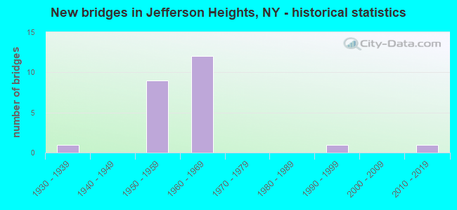
- New bridges - historical statistics
- 11930-1939
- 91950-1959
- 121960-1969
- 11990-1999
- 12010-2019

- Reconstructed bridges - Historical Statistics
- 11960-1969
- 01970-1979
- 21980-1989
- 11990-1999
- 32000-2009


- Bridge Condition - Deck
- 8.3%Excellent
- 8.3%Good
- 58.3%Satisfactory
- 16.7%Fair
- 8.3%Poor

- Bridge Condition - Superstructure
- 15.4%Excellent
- 7.7%Very good
- 15.4%Good
- 30.8%Satisfactory
- 30.8%Fair

- Bridge Condition - Substructure
- 7.7%Very good
- 15.4%Good
- 38.5%Satisfactory
- 30.8%Fair
- 7.7%Serious

- Bridge Condition - Channel
- 40.0%Excellent
- 40.0%Satisfactory
- 20.0%Fair
Find on map >> Show street view
Structure Number: 100749, Location: .1 MI S JCT 9W + 23 (Lat: 42.231744, Lng: -73.869942), Route carried "on" structure: US 9W, Year Built: 1933, Year Reconstructed: 1966, Status: Open, Structure Length: 0.64m (2.10ft), Average Daily Traffic: 11,885 (year 2020), Truck Traffic: 6%, Average Future Daily Traffic: 14,437 (year 2040), Design Load: H 20, Features Intersected: HANS VOSEN KILL
Minimum Vertical Clearance: 30+ m (98+ ft), Kilometerpoint: 12.663, Lanes on structure: 4, Base Highway Network: Yes, Owner: State Highway Agency, Approaching Roadway Width: 21.3m (69.9ft), Skew: 6 degrees, Material/Design: Concrete, Design/Construction: Culvert, Number Of Spans In Main Unit: 1, Length of Maximum Span: 4.5m (14.8ft)
Condition: Channel: Satisfactory, Culverts: Satisfactory, Operating Rating: 72.8 metric tons, Method Used To Determine Operating Rating: Field evaluation and documented engineering judgment, Inventory Rating: 29.4 metric tons, Method Used To Determine Inventory Rating: Field evaluation and documented engineering judgment, Structural Evaluation: Equal to present minimum criteria, Waterway Adequacy: Somewhat better than minimum adequacy, Approach Roadway Alignment: Equal to present desirable criteria, Length Of Structure Improvement: 0.64m (2.10ft), Designated Inspection Frequency: Every 24 months, Inspection Date: September 2020, Bridge Improvement Cost: $1,465,000, Roadway Improvement Cost: $858,000, Total Project Cost: $2,322,000 ( Estimate for 2021)
Find on map >> Show street view
Structure Number: 1007501, Location: JCT RTS 9W & 23 (Lat: 42.231647, Lng: -73.869806), Route carried "on" structure: State highway 23, Year Built: 1968, Year Reconstructed: 1988, Status: Open, Structure Length: 7.44m (24.41ft), Average Daily Traffic: 5,748 (year 2017), Truck Traffic: 9%, Average Future Daily Traffic: 5,774 (year 2040), Design Load: HS 20, Features Intersected: RTE 9W
Minimum Vertical Clearance: 30+ m (98+ ft), Kilometerpoint: 58.503, Lanes on structure: 2, Lanes under structure: 4, Base Highway Network: Yes, Owner: State Highway Agency, Approaching Roadway Width: 9.1m (29.9ft), Skew: 3 degrees, Material/Design: Steel, Design/Construction: Stringer/Multi-beam, Number Of Spans In Main Unit: 3, Length of Maximum Span: 28.6m (93.8ft), Curb-To-Curb Width: 9.1m (29.9ft), Out-to-Out Width: 10.1m (33.1ft)
Condition: Deck: Good, Superstructure: Fair, Substructure: Fair, Operating Rating: 98.0 metric tons, Method Used To Determine Operating Rating: Load Factor (LF), Inventory Rating: 59.0 metric tons, Method Used To Determine Inventory Rating: Load Factor (LF), Structural Evaluation: Somewhat better than minimum adequacy, Deck Geometry: Meets minimum limits, Underclear: Somewhat better than minimum adequacy, Approach Roadway Alignment: Equal to present desirable criteria, Length Of Structure Improvement: 7.43m (24.38ft), Designated Inspection Frequency: Every 24 months, Inspection Date: July 2021, Bridge Improvement Cost: $1,664,000, Roadway Improvement Cost: $975,000, Total Project Cost: $2,639,000 ( Estimate for 2021), Deck Structure Type: Concrete Cast-file-Place, Wearing Surface/Protective System: Wearing Surface: Integral Concrete, Deck Protection: Epoxy Coated Reinforcing
Find on map >> Show street view
Structure Number: 1007502, Location: JCT RTS 9W & 23 (Lat: 42.231486, Lng: -73.869836), Route carried "on" structure: State highway 23, Year Built: 1968, Year Reconstructed: 1998, Status: Open, Structure Length: 7.25m (23.79ft), Average Daily Traffic: 5,748 (year 2017), Truck Traffic: 9%, Average Future Daily Traffic: 5,774 (year 2040), Design Load: H 20, Features Intersected: RTE 9W
Minimum Vertical Clearance: 30+ m (98+ ft), Kilometerpoint: 58.519, Lanes on structure: 2, Lanes under structure: 4, Base Highway Network: Yes, Owner: State Highway Agency, Approaching Roadway Width: 9.8m (32.2ft), Skew: 3 degrees, Material/Design: Steel, Design/Construction: Stringer/Multi-beam, Number Of Spans In Main Unit: 3, Length of Maximum Span: 28.3m (92.8ft), Curb-To-Curb Width: 9.1m (29.9ft), Out-to-Out Width: 10.7m (35.1ft)
Condition: Deck: Satisfactory, Superstructure: Satisfactory, Substructure: Satisfactory, Inventory Rating: 62.6 metric tons, Method Used To Determine Inventory Rating: Load Factor (LF), Structural Evaluation: Equal to present minimum criteria, Deck Geometry: Meets minimum limits, Underclear: Meets minimum limits, Approach Roadway Alignment: Equal to present desirable criteria, Length Of Structure Improvement: 7.25m (23.79ft), Designated Inspection Frequency: Every 24 months, Inspection Date: July 2020, Bridge Improvement Cost: $1,728,000, Roadway Improvement Cost: $1,012,000, Total Project Cost: $2,740,000 ( Estimate for 2021), Deck Structure Type: Concrete Cast-file-Place, Wearing Surface/Protective System: Wearing Surface: Integral Concrete, Deck Protection: Epoxy Coated Reinforcing
Find on map >> Show street view
Structure Number: 1017781, Location: JCT RT 23 & I87 (Lat: 42.244319, Lng: -73.891439), Route carried "on" structure: State highway 23, Year Built: 1968, Status: Open, Structure Length: 5.36m (17.59ft), Average Daily Traffic: 5,216 (year 2011), Truck Traffic: 7%, Average Future Daily Traffic: 6,336 (year 2040), Design Load: HS 20+Mod, Features Intersected: 87IX NB, RTE I87
Minimum Vertical Clearance: 30+ m (98+ ft), Kilometerpoint: 56.041, Lanes on structure: 2, Lanes under structure: 4, Base Highway Network: Yes, Owner: State Highway Agency, Approaching Roadway Width: 8.5m (27.9ft), Skew: 1 degrees, Material/Design: Steel, Design/Construction: Stringer/Multi-beam, Number Of Spans In Main Unit: 2, Length of Maximum Span: 26.2m (86.0ft), Curb-To-Curb Width: 8.5m (27.9ft), Out-to-Out Width: 10.1m (33.1ft)
Condition: Deck: Satisfactory, Superstructure: Good, Substructure: Fair, Inventory Rating: 63.5 metric tons, Method Used To Determine Inventory Rating: Load Factor (LF), Structural Evaluation: Somewhat better than minimum adequacy, Deck Geometry: High priority of corrective action, Underclear: High priority of corrective action, Approach Roadway Alignment: Equal to present desirable criteria, Length Of Structure Improvement: 5.36m (17.59ft), Designated Inspection Frequency: Every 24 months, Inspection Date: October 2021, Bridge Improvement Cost: $1,246,000, Roadway Improvement Cost: $729,000, Total Project Cost: $1,975,000 ( Estimate for 2021), Deck Structure Type: Concrete Cast-file-Place, Wearing Surface/Protective System: Wearing Surface: Monolithic Concrete
Find on map >> Show street view
Structure Number: 1017782, Location: JCT RT 23 & I87 (Lat: 42.244422, Lng: -73.891314), Route carried "on" structure: State highway 23, Year Built: 1968, Status: Open, Structure Length: 5.36m (17.59ft), Average Daily Traffic: 5,216 (year 2011), Truck Traffic: 7%, Average Future Daily Traffic: 6,336 (year 2040), Features Intersected: 87IX NB, RTE I87
Minimum Vertical Clearance: 30+ m (98+ ft), Kilometerpoint: 56.041, Lanes on structure: 2, Lanes under structure: 4, Base Highway Network: Yes, Owner: State Highway Agency, Approaching Roadway Width: 8.5m (27.9ft), Skew: 1 degrees, Material/Design: Steel, Design/Construction: Stringer/Multi-beam, Number Of Spans In Main Unit: 2, Length of Maximum Span: 26.2m (86.0ft), Curb-To-Curb Width: 8.5m (27.9ft), Out-to-Out Width: 10.1m (33.1ft)
Condition: Deck: Satisfactory, Superstructure: Satisfactory, Substructure: Fair, Inventory Rating: 63.5 metric tons, Method Used To Determine Inventory Rating: Load Factor (LF), Structural Evaluation: Somewhat better than minimum adequacy, Deck Geometry: High priority of corrective action, Underclear: High priority of corrective action, Approach Roadway Alignment: Equal to present desirable criteria, Length Of Structure Improvement: 5.36m (17.59ft), Designated Inspection Frequency: Every 24 months, Inspection Date: October 2021, Bridge Improvement Cost: $1,246,000, Roadway Improvement Cost: $729,000, Total Project Cost: $1,975,000 ( Estimate for 2021), Deck Structure Type: Concrete Cast-file-Place, Wearing Surface/Protective System: Wearing Surface: Monolithic Concrete
Find on map >> Show street view
Structure Number: 1017799, Location: 0.4 MI SE JCT RT 23 & I87 (Lat: 42.239667, Lng: -73.887578), Route carried "on" structure: State highway 23, Year Built: 1968, Status: Open, Structure Length: 7.01m (23.00ft), Average Daily Traffic: 11,495 (year 2017), Truck Traffic: 9%, Average Future Daily Traffic: 11,549 (year 2040), Design Load: H 20, Features Intersected: RTE 911V
Minimum Vertical Clearance: 30+ m (98+ ft), Kilometerpoint: 56.653, Lanes on structure: 4, Lanes under structure: 3, Base Highway Network: Yes, Owner: State Highway Agency, Approaching Roadway Width: 17.1m (56.1ft), Skew: 35 degrees, Material/Design: Steel, Design/Construction: Stringer/Multi-beam, Number Of Spans In Main Unit: 3, Length of Maximum Span: 29.2m (95.8ft), Curb or Sidewalk Widths: Left: 0.5m (1.6ft), Right: 0.5m (1.6ft), Curb-To-Curb Width: 17.1m (56.1ft), Out-to-Out Width: 21.1m (69.2ft)
Condition: Deck: Fair, Superstructure: Fair, Substructure: Fair, Operating Rating: 89.8 metric tons, Method Used To Determine Operating Rating: Load Factor (LF), Inventory Rating: 53.5 metric tons, Method Used To Determine Inventory Rating: Load Factor (LF), Structural Evaluation: Somewhat better than minimum adequacy, Deck Geometry: Somewhat better than minimum adequacy, Underclear: Somewhat better than minimum adequacy, Approach Roadway Alignment: Better than present minimum criteria, Length Of Structure Improvement: 7.01m (23.00ft), Designated Inspection Frequency: Every 24 months, Inspection Date: July 2021, Bridge Improvement Cost: $3,361,000, Roadway Improvement Cost: $1,968,000, Total Project Cost: $5,330,000 ( Estimate for 2021), Deck Structure Type: Concrete Cast-file-Place, Wearing Surface/Protective System: Wearing Surface: Monolithic Concrete
Find on map >> Show street view
Structure Number: 1017809, Location: 0.7 MI SE JCT RT 23 & I87 (Lat: 42.237808, Lng: -73.883700), Route carried "on" structure: State highway 23, Year Built: 1968, Status: Open, Structure Length: 4.30m (14.11ft), Average Daily Traffic: 11,495 (year 2017), Truck Traffic: 9%, Average Future Daily Traffic: 11,549 (year 2040), Design Load: HS 20+Mod, Features Intersected: BROOKS LANE
Minimum Vertical Clearance: 30+ m (98+ ft), Kilometerpoint: 57.055, Lanes on structure: 5, Lanes under structure: 2, Base Highway Network: Yes, Owner: State Highway Agency, Approaching Roadway Width: 26.8m (87.9ft), Skew: 31 degrees, Material/Design: Steel, Design/Construction: Stringer/Multi-beam, Number Of Spans In Main Unit: 3, Length of Maximum Span: 14.6m (47.9ft), Curb or Sidewalk Widths: Left: 0.5m (1.6ft), Right: 0.5m (1.6ft), Curb-To-Curb Width: 20.1m (65.9ft), Out-to-Out Width: 24.1m (79.1ft)
Condition: Deck: Fair, Superstructure: Satisfactory, Substructure: Satisfactory, Operating Rating: 57.0 metric tons, Method Used To Determine Operating Rating: Load and Resistance Factor Rating (LRFR) rating reported by rating factor(RF) method using HL-93 loadings, Inventory Rating: 44.1 metric tons, Method Used To Determine Inventory Rating: Load and Resistance Factor Rating (LRFR) rating reported by rating factor(RF) method using HL-93 loadings, Structural Evaluation: Equal to present minimum criteria, Deck Geometry: Somewhat better than minimum adequacy, Underclear: Somewhat better than minimum adequacy, Approach Roadway Alignment: Equal to present minimum criteria, Length Of Structure Improvement: 4.29m (14.07ft), Designated Inspection Frequency: Every 24 months, Inspection Date: April 2021, Bridge Improvement Cost: $2,322,000, Roadway Improvement Cost: $1,360,000, Total Project Cost: $3,682,000 ( Estimate for 2021), Deck Structure Type: Concrete Cast-file-Place, Wearing Surface/Protective System: Wearing Surface: Bituminous
Find on map >> Show street view
Structure Number: 320068, Location: 3 MI.W.VILL.OF CATSKILL (Lat: 42.218808, Lng: -73.917431), Route carried "on" structure: Other road , Year Built: 2017, Status: Open, Structure Length: 3.26m (10.70ft), Average Daily Traffic: 177 (year 2013), Truck Traffic: 6%, Average Future Daily Traffic: 248 (year 2033), Features Intersected: KAATERSKILL CREEK, Facility Carried by Structure: CAUTERSKILL ROAD
Minimum Vertical Clearance: 32.69m (107.25ft), Kilometerpoint: 6.935, Lanes on structure: 1, Owner: County Highway Agency, Approaching Roadway Width: 5.5m (18.0ft), Material/Design: Steel, Design/Construction: Truss - Thru, Number Of Spans In Main Unit: 1, Length of Maximum Span: 31.1m (102.0ft), Curb-To-Curb Width: 5.5m (18.0ft), Out-to-Out Width: 6.0m (19.7ft)
Condition: Deck: Excellent, Superstructure: Excellent, Substructure: Very good, Channel: Satisfactory, Operating Rating: 87.1 metric tons, Method Used To Determine Operating Rating: Load Factor (LF), Inventory Rating: 51.7 metric tons, Method Used To Determine Inventory Rating: Load Factor (LF), Structural Evaluation: Equal to present desirable criteria, Deck Geometry: High priority of corrective action, Waterway Adequacy: Somewhat better than minimum adequacy, Approach Roadway Alignment: Meets minimum limits, Length Of Structure Improvement: 3.26m (10.70ft), Designated Inspection Frequency: Every 24 months, Critical Feature Inspection Frequency: Every 24 months, Inspection Date: September 2021, Critical Feature Inspection Date: September 2021, Bridge Improvement Cost: $1,486,000, Roadway Improvement Cost: $870,000, Total Project Cost: $2,356,000 ( Estimate for 2021), Deck Structure Type: Concrete Cast-file-Place, Wearing Surface/Protective System: Wearing Surface: Monolithic Concrete, Deck Protection: Epoxy Coated Reinforcing
Find on map >> Show street view
Structure Number: 330282, Location: 2.5 MI W VILL OF CATSKILL (Lat: 42.220378, Lng: -73.900497), Route carried "on" structure: County highway , Year Built: 1991, Year Reconstructed: 2013, Status: Open, Structure Length: 3.57m (11.71ft), Average Daily Traffic: 886 (year 2016), Truck Traffic: 3%, Average Future Daily Traffic: 1,240 (year 2036), Design Load: HL 93, Features Intersected: KAATERSKILL CREEK, Facility Carried by Structure: COUNTY ROAD 47
Minimum Vertical Clearance: 30+ m (98+ ft), Kilometerpoint: 2.961, Lanes on structure: 2, Owner: County Highway Agency, Approaching Roadway Width: 6.4m (21.0ft), Material/Design: Steel, Design/Construction: Truss - Thru, Number Of Spans In Main Unit: 1, Length of Maximum Span: 34.7m (113.8ft), Curb-To-Curb Width: 6.5m (21.3ft), Out-to-Out Width: 7.6m (24.9ft)
Condition: Deck: Satisfactory, Superstructure: Excellent, Substructure: Good, Channel: Fair, Operating Rating: 41.1 metric tons, Method Used To Determine Operating Rating: Load and Resistance Factor Rating (LRFR) rating reported by rating factor(RF) method using HL-93 loadings, Inventory Rating: 31.8 metric tons, Method Used To Determine Inventory Rating: Load and Resistance Factor Rating (LRFR) rating reported by rating factor(RF) method using HL-93 loadings, Structural Evaluation: Better than present minimum criteria, Deck Geometry: High priority of corrective action, Waterway Adequacy: Meets minimum limits, Approach Roadway Alignment: Equal to present minimum criteria, Length Of Structure Improvement: 3.56m (11.68ft), Designated Inspection Frequency: Every 24 months, Critical Feature Inspection Frequency: Every 24 months, Inspection Date: September 2021, Critical Feature Inspection Date: September 2021, Bridge Improvement Cost: $1,903,000, Roadway Improvement Cost: $1,114,000, Total Project Cost: $3,017,000 ( Estimate for 2021), Deck Structure Type: Concrete Cast-file-Place, Wearing Surface/Protective System: Wearing Surface: Integral Concrete, Deck Protection: Epoxy Coated Reinforcing
Find on map >> Show street view
Structure Number: 5513199, Location: 1.5 MI W VILLAGE CATSKILL (Lat: 42.217792, Lng: -73.914497), Route carried "on" structure: Interstate 87, Year Built: 1955, Year Reconstructed: 2005, Status: Open, Structure Length: 18.41m (60.40ft), Average Daily Traffic: 26,854 (year 2020), Truck Traffic: 28%, Average Future Daily Traffic: 31,983 (year 2040), Design Load: HS 20+Mod, Features Intersected: CAUTERSKILL ROAD, KAATER
Minimum Vertical Clearance: 30+ m (98+ ft), Kilometerpoint: 8.463, Lanes on structure: 4, Lanes under structure: 2, Base Highway Network: Yes, Toll: On Interstate toll segment, Owner: State Toll Authority, Approaching Roadway Width: 31.1m (102.0ft), Skew: 20 degrees, Material/Design: Steel continuous, Design/Construction: Truss - Deck, Number Of Spans In Main Unit: 3, Length of Maximum Span: 91.4m (299.9ft), Curb-To-Curb Width: 31.1m (102.0ft), Out-to-Out Width: 34.4m (112.9ft)
Condition: Deck: Satisfactory, Superstructure: Satisfactory, Substructure: Satisfactory, Channel: Excellent, Inventory Rating: 32.7 metric tons, Method Used To Determine Inventory Rating: Field evaluation and documented engineering judgment, Structural Evaluation: Equal to present minimum criteria, Deck Geometry: Superior to present desirable criteria, Underclear: Equal to present desirable criteria, Waterway Adequacy: Equal to present minimum criteria, Approach Roadway Alignment: Equal to present desirable criteria, Length Of Structure Improvement: 18.40m (60.37ft), Designated Inspection Frequency: Every 24 months, Critical Feature Inspection Frequency: Every 24 months, Inspection Date: December 2021, Critical Feature Inspection Date: December 2021, Bridge Improvement Cost: $47,458,000, Roadway Improvement Cost: $27,791,000, Total Project Cost: $75,249,000 ( Estimate for 2021), Deck Structure Type: Concrete Cast-file-Place, Wearing Surface/Protective System: Wearing Surface: Bituminous, Membrane: Other, Deck Protection: Epoxy Coated Reinforcing
Find on map >> Show street view
Structure Number: 55132, Location: 1.5 MI NW VILL CATSKILL (Lat: 42.236231, Lng: -73.901492), Route carried "on" structure: County highway , Year Built: 1953, Status: Open, Structure Length: 6.52m (21.39ft), Average Daily Traffic: 886 (year 2016), Truck Traffic: 3%, Average Future Daily Traffic: 1,240 (year 2036), Design Load: HS 20+Mod, Features Intersected: 87IX SB, RTE 87I, Facility Carried by Structure: OLD KINGS HIGHWAY
Minimum Vertical Clearance: 30+ m (98+ ft), Kilometerpoint: 4.907, Lanes on structure: 2, Lanes under structure: 4, Owner: State Toll Authority, Approaching Roadway Width: 8.5m (27.9ft), Material/Design: Steel, Design/Construction: Stringer/Multi-beam, Number Of Spans In Main Unit: 4, Length of Maximum Span: 19.2m (63.0ft), Curb or Sidewalk Widths: Left: 0.8m (2.6ft), Right: 0.8m (2.6ft), Curb-To-Curb Width: 7.9m (25.9ft), Out-to-Out Width: 10.1m (33.1ft)
Condition: Deck: Poor, Superstructure: Fair, Substructure: Serious, Operating Rating: 50.2 metric tons, Method Used To Determine Operating Rating: Load and Resistance Factor Rating (LRFR) rating reported by rating factor(RF) method using HL-93 loadings, Inventory Rating: 38.6 metric tons, Method Used To Determine Inventory Rating: Load and Resistance Factor Rating (LRFR) rating reported by rating factor(RF) method using HL-93 loadings, Structural Evaluation: High priority of corrective action, Deck Geometry: Somewhat better than minimum adequacy, Underclear: High priority of corrective action, Approach Roadway Alignment: Equal to present minimum criteria, Length Of Structure Improvement: 6.52m (21.39ft), Designated Inspection Frequency: Every 12 months, Inspection Date: April 2021, Bridge Improvement Cost: $1,463,000, Roadway Improvement Cost: $857,000, Total Project Cost: $2,319,000 ( Estimate for 2021), Deck Structure Type: Concrete Cast-file-Place, Wearing Surface/Protective System: Wearing Surface: Bituminous
Find on map >> Show street view
Structure Number: 5513219, Location: .5 MI S EXIT 21 OF I90 (Lat: 42.243200, Lng: -73.892819), Route carried "on" structure: Interstate 87, Year Built: 1955, Year Reconstructed: 2005, Status: Open, Structure Length: 22.31m (73.20ft), Average Daily Traffic: 26,854 (year 2020), Truck Traffic: 28%, Average Future Daily Traffic: 31,983 (year 2040), Design Load: HS 20+Mod, Features Intersected: CATSKILL CREEK
Minimum Vertical Clearance: 30+ m (98+ ft), Kilometerpoint: 11.826, Lanes on structure: 4, Base Highway Network: Yes, Toll: On Interstate toll segment, Owner: State Toll Authority, Approaching Roadway Width: 31.1m (102.0ft), Skew: 22 degrees, Material/Design: Steel continuous, Design/Construction: Truss - Deck, Number Of Spans In Main Unit: 3, Number Of Approach Spans: 2, Length of Maximum Span: 91.4m (299.9ft), Curb-To-Curb Width: 31.1m (102.0ft), Out-to-Out Width: 34.4m (112.9ft)
Condition: Deck: Satisfactory, Superstructure: Fair, Substructure: Satisfactory, Channel: Excellent, Operating Rating: 84.3 metric tons, Method Used To Determine Operating Rating: Field evaluation and documented engineering judgment, Inventory Rating: 32.7 metric tons, Method Used To Determine Inventory Rating: Field evaluation and documented engineering judgment, Structural Evaluation: Somewhat better than minimum adequacy, Deck Geometry: Superior to present desirable criteria, Waterway Adequacy: Meets minimum limits, Approach Roadway Alignment: Equal to present desirable criteria, Length Of Structure Improvement: 22.31m (73.20ft), Designated Inspection Frequency: Every 24 months, Critical Feature Inspection Frequency: Every 24 months, Inspection Date: November 2021, Critical Feature Inspection Date: November 2021, Bridge Improvement Cost: $56,661,000, Roadway Improvement Cost: $33,180,000, Total Project Cost: $89,841,000 ( Estimate for 2021), Deck Structure Type: Concrete Cast-file-Place, Wearing Surface/Protective System: Wearing Surface: Bituminous, Membrane: Other, Deck Protection: Epoxy Coated Reinforcing
Find on map >> Show street view
Structure Number: 551322, Location: AT INT 21 NYS THRUWAY (Lat: 42.247656, Lng: -73.887314), Route carried "on" structure: County highway , Year Built: 1952, Status: Open, Structure Length: 7.10m (23.29ft), Average Daily Traffic: 1,571 (year 2019), Truck Traffic: 18%, Average Future Daily Traffic: 2,489 (year 2040), Design Load: HS 20+Mod, Features Intersected: 87!X Northbound, RTE I87, Facility Carried by Structure: CR 23B
Minimum Vertical Clearance: 30+ m (98+ ft), Kilometerpoint: 0.145, Lanes on structure: 2, Lanes under structure: 7, Owner: State Toll Authority, Approaching Roadway Width: 11.0m (36.1ft), Skew: 1 degrees, Material/Design: Steel, Design/Construction: Stringer/Multi-beam, Number Of Spans In Main Unit: 4, Length of Maximum Span: 20.4m (66.9ft), Curb or Sidewalk Widths: Left: 0.8m (2.6ft), Right: 0.8m (2.6ft), Curb-To-Curb Width: 11.0m (36.1ft), Out-to-Out Width: 13.1m (43.0ft)
Condition: Deck: Satisfactory, Superstructure: Good, Substructure: Satisfactory, Operating Rating: 57.3 metric tons, Method Used To Determine Operating Rating: Load and Resistance Factor Rating (LRFR) rating reported by rating factor(RF) method using HL-93 loadings, Inventory Rating: 44.1 metric tons, Method Used To Determine Inventory Rating: Load and Resistance Factor Rating (LRFR) rating reported by rating factor(RF) method using HL-93 loadings, Structural Evaluation: Equal to present minimum criteria, Deck Geometry: Equal to present minimum criteria, Underclear: High priority of corrective action, Approach Roadway Alignment: Equal to present desirable criteria, Length Of Structure Improvement: 7.10m (23.29ft), Designated Inspection Frequency: Every 24 months, Inspection Date: March 2020, Bridge Improvement Cost: $2,293,000, Roadway Improvement Cost: $1,343,000, Total Project Cost: $3,636,000 ( Estimate for 2021), Deck Structure Type: Concrete Cast-file-Place, Wearing Surface/Protective System: Wearing Surface: Integral Concrete
Find on map >> Show street view
Structure Number: 5513249, Location: 1.5 MI NE JCT RTS 23(Lat: 42.257444, Lng: -73.879292), Route carried "on" structure: Interstate 87, Year Built: 1955, Year Reconstructed: 1993, Status: Open, Structure Length: 1.25m (4.10ft), Average Daily Traffic: 26,034 (year 2020), Truck Traffic: 27%, Average Future Daily Traffic: 31,006 (year 2040), Design Load: HS 20+Mod, Features Intersected: LEEDS ATHENS ROAD
Minimum Vertical Clearance: 30+ m (98+ ft), Kilometerpoint: 13.902, Lanes on structure: 4, Lanes under structure: 2, Base Highway Network: Yes, Toll: On Interstate toll segment, Owner: State Toll Authority, Approaching Roadway Width: 36.6m (120.1ft), Skew: 32 degrees, Material/Design: Concrete, Design/Construction: Frame, Number Of Spans In Main Unit: 1, Length of Maximum Span: 9.4m (30.8ft), Curb-To-Curb Width: 38.3m (125.7ft), Out-to-Out Width: 41.0m (134.5ft)
Condition: Superstructure: Very good, Substructure: Good, Operating Rating: 79.3 metric tons, Method Used To Determine Operating Rating: Field evaluation and documented engineering judgment, Inventory Rating: 32.7 metric tons, Method Used To Determine Inventory Rating: Field evaluation and documented engineering judgment, Structural Evaluation: Better than present minimum criteria, Deck Geometry: Superior to present desirable criteria, Underclear: High priority of corrective action, Approach Roadway Alignment: Equal to present desirable criteria, Length Of Structure Improvement: 1.24m (4.07ft), Designated Inspection Frequency: Every 24 months, Inspection Date: June 2021, Bridge Improvement Cost: $2,585,000, Roadway Improvement Cost: $1,514,000, Total Project Cost: $4,099,000 ( Estimate for 2021), Wearing Surface/Protective System: Wearing Surface: Bituminous, Membrane: Preformed Fabric
Structure Number: 5513249, Location: 1.5 MI NE JCT RTS 23
Minimum Vertical Clearance: 30+ m (98+ ft), Kilometerpoint: 13.902, Lanes on structure: 4, Lanes under structure: 2, Base Highway Network: Yes, Toll: On Interstate toll segment, Owner: State Toll Authority, Approaching Roadway Width: 36.6m (120.1ft), Skew: 32 degrees, Material/Design: Concrete, Design/Construction: Frame, Number Of Spans In Main Unit: 1, Length of Maximum Span: 9.4m (30.8ft), Curb-To-Curb Width: 38.3m (125.7ft), Out-to-Out Width: 41.0m (134.5ft)
Condition: Superstructure: Very good, Substructure: Good, Operating Rating: 79.3 metric tons, Method Used To Determine Operating Rating: Field evaluation and documented engineering judgment, Inventory Rating: 32.7 metric tons, Method Used To Determine Inventory Rating: Field evaluation and documented engineering judgment, Structural Evaluation: Better than present minimum criteria, Deck Geometry: Superior to present desirable criteria, Underclear: High priority of corrective action, Approach Roadway Alignment: Equal to present desirable criteria, Length Of Structure Improvement: 1.24m (4.07ft), Designated Inspection Frequency: Every 24 months, Inspection Date: June 2021, Bridge Improvement Cost: $2,585,000, Roadway Improvement Cost: $1,514,000, Total Project Cost: $4,099,000 ( Estimate for 2021), Wearing Surface/Protective System: Wearing Surface: Bituminous, Membrane: Preformed Fabric
Find on map >> Show street view
Structure Number: 1007501, Location: JCT RTS 9W & 23 (Lat: 42.231647, Lng: -73.869806), Route carried "under" structure: US 9W, Year Built: 1968, Structure Length: 0. m, Average Daily Traffic: 14,413 (year 2013), Features Intersected: RTE 9W, Facility Carried by Structure: RTE 23
Minimum Vertical Clearance: 5.36m (17.59ft), Kilometerpoint: 11.762, Lanes on structure: 2, Lanes under structure: 4, Material/Design: Steel, Design/Construction: Stringer/Multi-beam, Length of Maximum Span: 28.6m (93.8ft)
Find on map >> Show street view
Structure Number: 1007502, Location: JCT RTS 9W & 23 (Lat: 42.231486, Lng: -73.869836), Route carried "under" structure: US 9W, Year Built: 1968, Structure Length: 0. m, Average Daily Traffic: 11,034 (year 2000), Features Intersected: RTE 9W, Facility Carried by Structure: RTE 23
Minimum Vertical Clearance: 6.68m (21.92ft), Kilometerpoint: 11.762, Lanes on structure: 2, Lanes under structure: 4, Material/Design: Steel, Design/Construction: Stringer/Multi-beam, Length of Maximum Span: 28.3m (92.8ft)
Find on map >> Show street view
Structure Number: 1017781, Location: JCT RT 23 & I87 (Lat: 42.244319, Lng: -73.891439), Route carried "under" structure: Interstate 87, Year Built: 1968, Structure Length: 0. m, Average Daily Traffic: 34,076 (year 2013), Features Intersected: 87IX NB, RTE I87, Facility Carried by Structure: RTE 23
Minimum Vertical Clearance: 5.13m (16.83ft), Kilometerpoint: 182.396, Lanes on structure: 2, Lanes under structure: 2, Toll: On toll road, Material/Design: Steel, Design/Construction: Stringer/Multi-beam, Length of Maximum Span: 26.2m (86.0ft)
Find on map >> Show street view
Structure Number: 1017782, Location: JCT RT 23 & I87 (Lat: 42.244422, Lng: -73.891314), Route carried "under" structure: Interstate 87, Year Built: 1968, Structure Length: 0. m, Average Daily Traffic: 34,076 (year 2013), Features Intersected: 87IX NB, RTE I87, Facility Carried by Structure: RTE 23
Minimum Vertical Clearance: 5.31m (17.42ft), Kilometerpoint: 182.380, Lanes on structure: 2, Lanes under structure: 2, Toll: On toll road, Material/Design: Steel, Design/Construction: Stringer/Multi-beam, Length of Maximum Span: 26.2m (86.0ft)
Find on map >> Show street view
Structure Number: 1017799, Location: 0.4 MI SE JCT RT 23 & I87 (Lat: 42.239667, Lng: -73.887578), Route carried "under" structure: Alternate Other road 911V, Year Built: 1968, Structure Length: 0. m, Average Daily Traffic: 12,250 (year 2013), Features Intersected: RTE 911V, Facility Carried by Structure: RTE 23
Minimum Vertical Clearance: 4.80m (15.75ft), Kilometerpoint: 0.000, Lanes on structure: 4, Lanes under structure: 3, Material/Design: Steel, Design/Construction: Stringer/Multi-beam, Length of Maximum Span: 29.2m (95.8ft)
Find on map >> Show street view
Structure Number: 1017809, Location: 0.7 MI SE JCT RT 23 & I87 (Lat: 42.237808, Lng: -73.883700), Route carried "under" structure: Alternate City street , Year Built: 1968, Structure Length: 0. m, Features Intersected: BROOKS LANE, Facility Carried by Structure: RTE 23
Minimum Vertical Clearance: 4.37m (14.34ft), Kilometerpoint: 0.000, Lanes on structure: 5, Lanes under structure: 2, Material/Design: Steel, Design/Construction: Stringer/Multi-beam, Length of Maximum Span: 14.6m (47.9ft)
Find on map >> Show street view
Structure Number: 5513199, Location: 1.5 MI W VILLAGE CATSKILL (Lat: 42.217792, Lng: -73.914497), Route carried "under" structure: Other road , Year Built: 1955, Structure Length: 0. m, Average Daily Traffic: 177 (year 2013), Truck Traffic: 6%, Features Intersected: CAUTERSKILL ROAD, KAATER, Facility Carried by Structure: RTE I87
Minimum Vertical Clearance: 22.86m (75.00ft), Kilometerpoint: 6.935, Lanes on structure: 4, Lanes under structure: 2, Material/Design: Steel continuous, Design/Construction: Truss - Deck, Length of Maximum Span: 91.4m (299.9ft)
Find on map >> Show street view
Structure Number: 55132, Location: 1.5 MI NW VILL CATSKILL (Lat: 42.236231, Lng: -73.901492), Route carried "under" structure: Interstate 87, Year Built: 1953, Structure Length: 0. m, Average Daily Traffic: 17,449 (year 1978), Features Intersected: 87IX SB, RTE 87I, Facility Carried by Structure: OLD KINGS HIGHWAY
Minimum Vertical Clearance: 5.38m (17.65ft), Kilometerpoint: 181.125, Lanes on structure: 2, Lanes under structure: 2, Toll: On toll road, Material/Design: Steel, Design/Construction: Stringer/Multi-beam, Length of Maximum Span: 19.2m (63.0ft)
Find on map >> Show street view
Structure Number: 551322, Location: AT INT 21 NYS THRUWAY (Lat: 42.247656, Lng: -73.887314), Route carried "under" structure: Interstate 87, Year Built: 1952, Structure Length: 0. m, Average Daily Traffic: 34,440 (year 2014), Features Intersected: 87!X Northbound, RTE I87, Facility Carried by Structure: CR 23B
Minimum Vertical Clearance: 4.47m (14.67ft), Kilometerpoint: 182.847, Lanes on structure: 2, Lanes under structure: 5, Toll: On Interstate toll segment, Material/Design: Steel, Design/Construction: Stringer/Multi-beam, Length of Maximum Span: 20.4m (66.9ft)
Find on map >> Show street view
Structure Number: 5513249, Location: 1.5 MI NE JCT RTS 23(Lat: 42.257444, Lng: -73.879292), Route carried "under" structure: Other road , Year Built: 1955, Structure Length: 0. m, Truck Traffic: 6%, Features Intersected: LEEDS ATHENS ROAD, Facility Carried by Structure: RTE I87
Minimum Vertical Clearance: 4.27m (14.01ft), Kilometerpoint: 1.770, Lanes on structure: 4, Lanes under structure: 2, Material/Design: Concrete, Design/Construction: Frame, Length of Maximum Span: 9.4m (30.8ft)
Structure Number: 5513249, Location: 1.5 MI NE JCT RTS 23
Minimum Vertical Clearance: 4.27m (14.01ft), Kilometerpoint: 1.770, Lanes on structure: 4, Lanes under structure: 2, Material/Design: Concrete, Design/Construction: Frame, Length of Maximum Span: 9.4m (30.8ft)