Bridge Statistics for Ischua, New York (NY)
Condition, Traffic, Stress, Structural Evaluation, Project Costs
- National Bridge Inventory (NBI) Statistics
- 13Number of bridges
- 75ft / 23.0mTotal length
- $15,810,000Total costs
- 15,466Total average daily traffic
- 2,286Total average daily truck traffic
- 16,196Total future (year 2036) average daily traffic
- National Bridge Inventory (NBI) Registered Bridges for Ischua
- No street view available for this location
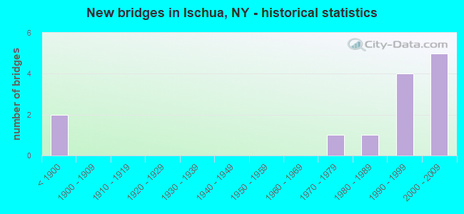
- New bridges - historical statistics
- 2Before 1900
- 11970-1979
- 11980-1989
- 41990-1999
- 52000-2009

- Reconstructed bridges - Historical Statistics
- 11980-1989
- 21990-1999


- Bridge Condition - Deck
- 20.0%Very good
- 60.0%Good
- 20.0%Satisfactory

- Bridge Condition - Superstructure
- 20.0%Very good
- 70.0%Good
- 10.0%Poor

- Bridge Condition - Substructure
- 50.0%Very good
- 30.0%Good
- 10.0%Satisfactory
- 10.0%Serious

- Bridge Condition - Channel
- 8.3%Very good
- 41.7%Good
- 41.7%Satisfactory
- 8.3%Fair
Find on map >> Show street view
Structure Number: 10117, Location: 3.2 MI N JCT RTS 16 + 17 (Lat: 42.221417, Lng: -78.378261), Route carried "on" structure: State highway 16, Year Built: 2008, Status: Open, Structure Length: 0.76m (2.49ft), Average Daily Traffic: 3,415 (year 2018), Truck Traffic: 16%, Average Future Daily Traffic: 3,447 (year 2040), Design Load: HS 25 or greater, Features Intersected: FARWELL HOLLOW
Minimum Vertical Clearance: 30+ m (98+ ft), Kilometerpoint: 31.311, Lanes on structure: 2, Base Highway Network: Yes, Owner: State Highway Agency, Approaching Roadway Width: 11.6m (38.1ft), Material/Design: Concrete, Design/Construction: Frame, Number Of Spans In Main Unit: 1, Length of Maximum Span: 7.3m (24.0ft), Curb-To-Curb Width: 12.0m (39.4ft), Out-to-Out Width: 13.0m (42.7ft)
Condition: Deck: Good, Superstructure: Good, Substructure: Good, Channel: Satisfactory, Operating Rating: 77.7 metric tons, Method Used To Determine Operating Rating: Field evaluation and documented engineering judgment, Inventory Rating: 40.8 metric tons, Method Used To Determine Inventory Rating: Field evaluation and documented engineering judgment, Structural Evaluation: Better than present minimum criteria, Deck Geometry: Somewhat better than minimum adequacy, Waterway Adequacy: Equal to present minimum criteria, Approach Roadway Alignment: Equal to present desirable criteria, Length Of Structure Improvement: 0.76m (2.49ft), Designated Inspection Frequency: Every 24 months, Inspection Date: May 2020, Bridge Improvement Cost: $493,000, Roadway Improvement Cost: $289,000, Total Project Cost: $782,000 ( Estimate for 2021), Wearing Surface/Protective System: Wearing Surface: Bituminous
Find on map >> Show street view
Structure Number: 109552, Location: 2.2 MI N JCT RTS 16 + 17 (Lat: 42.206944, Lng: -78.376325), Route carried "on" structure: State highway 16, Year Built: 1971, Status: Open, Structure Length: 0.70m (2.30ft), Average Daily Traffic: 3,415 (year 2018), Truck Traffic: 16%, Average Future Daily Traffic: 3,447 (year 2040), Design Load: H 20, Features Intersected: BRANCH ISCHUA CRK
Minimum Vertical Clearance: 30+ m (98+ ft), Kilometerpoint: 29.686, Lanes on structure: 2, Base Highway Network: Yes, Owner: State Highway Agency, Approaching Roadway Width: 13.7m (44.9ft), Material/Design: Steel, Design/Construction: Culvert, Number Of Spans In Main Unit: 2, Length of Maximum Span: 3.0m (9.8ft)
Condition: Channel: Fair, Culverts: Good, Operating Rating: 72.1 metric tons, Method Used To Determine Operating Rating: Field evaluation and documented engineering judgment, Inventory Rating: 32.7 metric tons, Method Used To Determine Inventory Rating: Field evaluation and documented engineering judgment, Structural Evaluation: Better than present minimum criteria, Waterway Adequacy: Somewhat better than minimum adequacy, Approach Roadway Alignment: Equal to present desirable criteria, Length Of Structure Improvement: 0.70m (2.30ft), Designated Inspection Frequency: Every 24 months, Inspection Date: September 2020, Bridge Improvement Cost: $266,000, Roadway Improvement Cost: $156,000, Total Project Cost: $421,000 ( Estimate for 2021), Wearing Surface/Protective System: Wearing Surface: Bituminous
Find on map >> Show street view
Structure Number: 109553, Location: 5.5 MI N JCT RTS 16 + 17 (Lat: 42.247194, Lng: -78.398858), Route carried "on" structure: State highway 16, Year Built: 2008, Status: Open, Structure Length: 0.76m (2.49ft), Average Daily Traffic: 3,415 (year 2018), Truck Traffic: 16%, Average Future Daily Traffic: 3,447 (year 2040), Design Load: H 20, Features Intersected: BRANCH ISCHUA CRK
Minimum Vertical Clearance: 30+ m (98+ ft), Kilometerpoint: 35.076, Lanes on structure: 2, Base Highway Network: Yes, Owner: State Highway Agency, Approaching Roadway Width: 11.9m (39.0ft), Material/Design: Concrete, Design/Construction: Frame, Number Of Spans In Main Unit: 1, Length of Maximum Span: 7.3m (24.0ft), Curb or Sidewalk Widths: Left: 2.7m (8.9ft), Right: 2.7m (8.9ft), Curb-To-Curb Width: 12.0m (39.4ft), Out-to-Out Width: 27.6m (90.6ft)
Condition: Deck: Very good, Superstructure: Good, Substructure: Very good, Channel: Satisfactory, Operating Rating: 68.0 metric tons, Method Used To Determine Operating Rating: Load Factor (LF), Inventory Rating: 40.8 metric tons, Method Used To Determine Inventory Rating: Load Factor (LF), Structural Evaluation: Better than present minimum criteria, Deck Geometry: Somewhat better than minimum adequacy, Waterway Adequacy: Equal to present minimum criteria, Approach Roadway Alignment: Equal to present desirable criteria, Length Of Structure Improvement: 0.76m (2.49ft), Designated Inspection Frequency: Every 24 months, Inspection Date: May 2020, Bridge Improvement Cost: $860,000, Roadway Improvement Cost: $504,000, Total Project Cost: $1,364,000 ( Estimate for 2021), Wearing Surface/Protective System: Wearing Surface: Bituminous, Membrane: Other
Find on map >> Show street view
Structure Number: 109554, Location: 5.7 MI N JCT SH 16 & I86 (Lat: 42.247936, Lng: -78.400717), Route carried "on" structure: State highway 16, Year Built: 2007, Status: Open, Structure Length: 0.76m (2.49ft), Average Daily Traffic: 3,415 (year 2018), Truck Traffic: 16%, Average Future Daily Traffic: 3,447 (year 2040), Design Load: HS 25 or greater, Features Intersected: BRN ISCHUA CREEK
Minimum Vertical Clearance: 30+ m (98+ ft), Kilometerpoint: 35.253, Lanes on structure: 2, Base Highway Network: Yes, Owner: State Highway Agency, Approaching Roadway Width: 11.9m (39.0ft), Material/Design: Concrete, Design/Construction: Culvert, Number Of Spans In Main Unit: 1, Length of Maximum Span: 7.3m (24.0ft), Curb or Sidewalk Widths: Left: 2.8m (9.2ft), Right: 2.8m (9.2ft), Curb-To-Curb Width: 12.0m (39.4ft), Out-to-Out Width: 19.2m (63.0ft)
Condition: Channel: Good, Culverts: Good, Operating Rating: 68.0 metric tons, Method Used To Determine Operating Rating: Load Factor (LF), Inventory Rating: 40.8 metric tons, Method Used To Determine Inventory Rating: Load Factor (LF), Structural Evaluation: Better than present minimum criteria, Deck Geometry: Somewhat better than minimum adequacy, Waterway Adequacy: Somewhat better than minimum adequacy, Approach Roadway Alignment: Equal to present desirable criteria, Length Of Structure Improvement: 0.76m (2.49ft), Designated Inspection Frequency: Every 24 months, Inspection Date: October 2021, Bridge Improvement Cost: $404,000, Roadway Improvement Cost: $237,000, Total Project Cost: $641,000 ( Estimate for 2021), Wearing Surface/Protective System: Wearing Surface: Bituminous
Find on map >> Show street view
Structure Number: 3322, Location: 4.2 MI NW OF MAPLEHURST (Lat: 42.208333, Lng: -78.453056), Route carried "on" structure: County highway , Year Built: 2000, Status: Open, Structure Length: 1.07m (3.51ft), Average Daily Traffic: 308 (year 2020), Truck Traffic: 6%, Average Future Daily Traffic: 311 (year 2040), Design Load: HS 25 or greater, Features Intersected: HARDSCRABBLE CRK, Facility Carried by Structure: FIVE MILE ROAD
Minimum Vertical Clearance: 30+ m (98+ ft), Kilometerpoint: 15.044, Lanes on structure: 2, Owner: County Highway Agency, Approaching Roadway Width: 10.7m (35.1ft), Skew: 1 degrees, Material/Design: Prestressed concrete, Design/Construction: Box Beam or Girders - Multiple, Number Of Spans In Main Unit: 1, Length of Maximum Span: 9.7m (31.8ft), Curb-To-Curb Width: 9.4m (30.8ft), Out-to-Out Width: 10.1m (33.1ft)
Condition: Deck: Good, Superstructure: Good, Substructure: Very good, Channel: Satisfactory, Inventory Rating: 62.6 metric tons, Method Used To Determine Inventory Rating: Load Factor (LF), Structural Evaluation: Better than present minimum criteria, Deck Geometry: Equal to present minimum criteria, Waterway Adequacy: Meets minimum limits, Approach Roadway Alignment: Equal to present desirable criteria, Length Of Structure Improvement: 1.06m (3.48ft), Designated Inspection Frequency: Every 24 months, Inspection Date: May 2020, Bridge Improvement Cost: $430,000, Roadway Improvement Cost: $252,000, Total Project Cost: $682,000 ( Estimate for 2021), Deck Structure Type: Concrete Cast-file-Place, Wearing Surface/Protective System: Wearing Surface: Integral Concrete, Deck Protection: Epoxy Coated Reinforcing
Find on map >> Show street view
Structure Number: 332201, Location: 4.7 MILES EAST OF ISCHUA (Lat: 42.256769, Lng: -78.309250), Route carried "on" structure: County highway , Year Built: 2006, Status: Open, Structure Length: 2.10m (6.89ft), Average Daily Traffic: 458 (year 2018), Truck Traffic: 7%, Average Future Daily Traffic: 641 (year 2038), Design Load: HS 25 or greater, Features Intersected: TRIB OF CUBA LAKE, Facility Carried by Structure: ABBOTTS ROAD
Minimum Vertical Clearance: 30+ m (98+ ft), Kilometerpoint: 0.000, Lanes on structure: 2, Owner: County Highway Agency, Approaching Roadway Width: 7.9m (25.9ft), Skew: 1 degrees, Material/Design: Prestressed concrete, Design/Construction: Box Beam or Girders - Multiple, Number Of Spans In Main Unit: 1, Length of Maximum Span: 19.8m (65.0ft), Curb-To-Curb Width: 9.1m (29.9ft), Out-to-Out Width: 10.1m (33.1ft)
Condition: Deck: Very good, Superstructure: Very good, Substructure: Very good, Channel: Good, Operating Rating: 69.9 metric tons, Method Used To Determine Operating Rating: Load Factor (LF), Inventory Rating: 41.7 metric tons, Method Used To Determine Inventory Rating: Load Factor (LF), Structural Evaluation: Equal to present desirable criteria, Deck Geometry: Equal to present minimum criteria, Waterway Adequacy: Equal to present minimum criteria, Approach Roadway Alignment: Equal to present desirable criteria, Length Of Structure Improvement: 2.10m (6.89ft), Designated Inspection Frequency: Every 24 months, Inspection Date: November 2020, Bridge Improvement Cost: $495,000, Roadway Improvement Cost: $290,000, Total Project Cost: $784,000 ( Estimate for 2021), Wearing Surface/Protective System: Wearing Surface: Integral Concrete
Find on map >> Show street view
Structure Number: 332202, Location: 4.2 MILES EAST OF ISCHUA (Lat: 42.256933, Lng: -78.318078), Route carried "on" structure: County highway , Year Built: 1995, Status: Open, Structure Length: 1.28m (4.20ft), Average Daily Traffic: 368 (year 2018), Truck Traffic: 5%, Average Future Daily Traffic: 515 (year 2038), Design Load: HS 25 or greater, Features Intersected: TRIB OF CUBA LAKE, Facility Carried by Structure: ABBOTTS ROAD
Minimum Vertical Clearance: 30+ m (98+ ft), Kilometerpoint: 15.977, Lanes on structure: 2, Owner: County Highway Agency, Approaching Roadway Width: 6.7m (22.0ft), Skew: 3 degrees, Material/Design: Prestressed concrete, Design/Construction: Box Beam or Girders - Multiple, Number Of Spans In Main Unit: 1, Length of Maximum Span: 12.1m (39.7ft), Curb-To-Curb Width: 9.5m (31.2ft), Out-to-Out Width: 10.1m (33.1ft)
Condition: Deck: Good, Superstructure: Good, Substructure: Very good, Channel: Very good, Operating Rating: 88.0 metric tons, Method Used To Determine Operating Rating: Load Factor (LF), Inventory Rating: 52.6 metric tons, Method Used To Determine Inventory Rating: Load Factor (LF), Structural Evaluation: Better than present minimum criteria, Deck Geometry: Equal to present minimum criteria, Waterway Adequacy: Somewhat better than minimum adequacy, Approach Roadway Alignment: Equal to present desirable criteria, Length Of Structure Improvement: 1.28m (4.20ft), Designated Inspection Frequency: Every 24 months, Inspection Date: July 2021, Bridge Improvement Cost: $591,000, Roadway Improvement Cost: $346,000, Total Project Cost: $936,000 ( Estimate for 2021), Deck Structure Type: Concrete Cast-file-Place, Wearing Surface/Protective System: Wearing Surface: Integral Concrete
Find on map >> Show street view
Structure Number: 332203, Location: 3.7 MILES SE OF ELGIN (Lat: 42.259256, Lng: -78.321547), Route carried "on" structure: County highway , Year Built: 1987, Year Reconstructed: 1991, Status: Open, Structure Length: 1.22m (4.00ft), Average Daily Traffic: 368 (year 2018), Truck Traffic: 5%, Average Future Daily Traffic: 515 (year 2038), Design Load: HS 20, Features Intersected: TRIB OF CUBA LAKE, Facility Carried by Structure: ABBOTTS ROAD
Minimum Vertical Clearance: 30+ m (98+ ft), Kilometerpoint: 15.607, Lanes on structure: 2, Owner: County Highway Agency, Approaching Roadway Width: 6.4m (21.0ft), Skew: 4 degrees, Material/Design: Steel, Design/Construction: Stringer/Multi-beam, Number Of Spans In Main Unit: 1, Length of Maximum Span: 11.8m (38.7ft), Curb-To-Curb Width: 7.5m (24.6ft), Out-to-Out Width: 7.9m (25.9ft)
Condition: Deck: Satisfactory, Superstructure: Good, Substructure: Good, Channel: Good, Operating Rating: 54.4 metric tons, Method Used To Determine Operating Rating: Load and Resistance Factor Rating (LRFR) rating reported by rating factor(RF) method using HL-93 loadings, Inventory Rating: 41.8 metric tons, Method Used To Determine Inventory Rating: Load and Resistance Factor Rating (LRFR) rating reported by rating factor(RF) method using HL-93 loadings, Structural Evaluation: Better than present minimum criteria, Deck Geometry: Somewhat better than minimum adequacy, Waterway Adequacy: Meets minimum limits, Approach Roadway Alignment: Equal to present minimum criteria, Length Of Structure Improvement: 1.21m (3.97ft), Designated Inspection Frequency: Every 24 months, Inspection Date: July 2021, Bridge Improvement Cost: $662,000, Roadway Improvement Cost: $388,000, Total Project Cost: $1,050,000 ( Estimate for 2021), Deck Structure Type: Wood or Timber, Wearing Surface/Protective System: Wearing Surface: Bituminous
Find on map >> Show street view
Structure Number: 332204, Location: 0.3 MI S OF ISCHUA (Lat: 42.242986, Lng: -78.397706), Route carried "on" structure: Other road , Year Built: 1993, Status: Open, Structure Length: 3.38m (11.09ft), Average Daily Traffic: 67 (year 2018), Truck Traffic: 9%, Average Future Daily Traffic: 94 (year 2038), Design Load: HS 25 or greater, Features Intersected: ISCHUA CREEK, Facility Carried by Structure: DUTCH HILL ROAD
Minimum Vertical Clearance: 30+ m (98+ ft), Kilometerpoint: 4.586, Lanes on structure: 2, Owner: County Highway Agency, Approaching Roadway Width: 7.9m (25.9ft), Material/Design: Prestressed concrete, Design/Construction: Box Beam or Girders - Multiple, Number Of Spans In Main Unit: 1, Length of Maximum Span: 32.9m (107.9ft), Curb-To-Curb Width: 8.4m (27.6ft), Out-to-Out Width: 9.0m (29.5ft)
Condition: Deck: Good, Superstructure: Good, Substructure: Very good, Channel: Good, Operating Rating: 82.0 metric tons, Method Used To Determine Operating Rating: Load and Resistance Factor Rating (LRFR) rating reported by rating factor(RF) method using HL-93 loadings, Inventory Rating: 53.8 metric tons, Method Used To Determine Inventory Rating: Load and Resistance Factor Rating (LRFR) rating reported by rating factor(RF) method using HL-93 loadings, Structural Evaluation: Better than present minimum criteria, Deck Geometry: Equal to present minimum criteria, Waterway Adequacy: Equal to present minimum criteria, Approach Roadway Alignment: Equal to present minimum criteria, Length Of Structure Improvement: 3.38m (11.09ft), Designated Inspection Frequency: Every 24 months, Inspection Date: July 2021, Bridge Improvement Cost: $1,057,000, Roadway Improvement Cost: $619,000, Total Project Cost: $1,677,000 ( Estimate for 2021), Deck Structure Type: Concrete Cast-file-Place, Wearing Surface/Protective System: Wearing Surface: Integral Concrete, Deck Protection: Epoxy Coated Reinforcing
Find on map >> Show street view
Structure Number: 332205, Location: 2.3 MILES SE OF ISCHUA (Lat: 42.219117, Lng: -78.379603), Route carried "on" structure: County highway , Year Built: 1891, Year Reconstructed: 1990, Status: Open, Structure Length: 3.11m (10.20ft), Average Daily Traffic: 85 (year 2018), Truck Traffic: 5%, Average Future Daily Traffic: 119 (year 2038), Design Load: HS 20, Features Intersected: ISCHUA CREEK, Facility Carried by Structure: FARWELL ROAD
Minimum Vertical Clearance: 30+ m (98+ ft), Kilometerpoint: 0.628, Lanes on structure: 1, Owner: County Highway Agency, Approaching Roadway Width: 5.2m (17.1ft), Material/Design: Prestressed concrete, Design/Construction: Box Beam or Girders - Multiple, Number Of Spans In Main Unit: 1, Length of Maximum Span: 30.4m (99.7ft), Curb-To-Curb Width: 5.0m (16.4ft), Out-to-Out Width: 5.3m (17.4ft)
Condition: Deck: Good, Superstructure: Good, Substructure: Satisfactory, Channel: Good, Operating Rating: 30.1 metric tons, Method Used To Determine Operating Rating: Load and Resistance Factor Rating (LRFR) rating reported by rating factor(RF) method using HL-93 loadings, Inventory Rating: 19.1 metric tons, Method Used To Determine Inventory Rating: Load and Resistance Factor Rating (LRFR) rating reported by rating factor(RF) method using HL-93 loadings, Structural Evaluation: Somewhat better than minimum adequacy, Deck Geometry: High priority of corrective action, Waterway Adequacy: Somewhat better than minimum adequacy, Approach Roadway Alignment: Better than present minimum criteria, Length Of Structure Improvement: 3.10m (10.17ft), Designated Inspection Frequency: Every 24 months, Inspection Date: June 2020, Bridge Improvement Cost: $475,000, Roadway Improvement Cost: $278,000, Total Project Cost: $753,000 ( Estimate for 2021), Wearing Surface/Protective System: Wearing Surface: Bituminous
Find on map >> Show street view
Structure Number: 332206, Location: 0.2 MI SW OF ISCHUA (Lat: 42.246981, Lng: -78.404486), Route carried "on" structure: Other road , Year Built: 1893, Year Reconstructed: 1997, Status: Posted for load, Structure Length: 3.20m (10.50ft), Average Daily Traffic: 17 (year 2018), Average Future Daily Traffic: 24 (year 2038), Features Intersected: ISCHUA CREEK, Facility Carried by Structure: BAXTER MILL ROAD
Minimum Vertical Clearance: 5.99m (19.65ft), Kilometerpoint: 0.306, Lanes on structure: 1, Owner: County Highway Agency, Approaching Roadway Width: 2.4m (7.9ft), Material/Design: Steel, Design/Construction: Truss - Thru, Number Of Spans In Main Unit: 1, Length of Maximum Span: 31.0m (101.7ft), Curb-To-Curb Width: 4.1m (13.5ft), Out-to-Out Width: 4.3m (14.1ft)
Condition: Deck: Satisfactory, Superstructure: Poor, Substructure: Serious, Channel: Satisfactory, Operating Rating: 12.3 metric tons, Method Used To Determine Operating Rating: Load and Resistance Factor Rating (LRFR) rating reported by rating factor(RF) method using HL-93 loadings, Inventory Rating: 9.7 metric tons, Method Used To Determine Inventory Rating: Load and Resistance Factor Rating (LRFR) rating reported by rating factor(RF) method using HL-93 loadings, Structural Evaluation: High priority of corrective action, Deck Geometry: Somewhat better than minimum adequacy, Waterway Adequacy: Meets minimum limits, Approach Roadway Alignment: Meets minimum limits, Bridge Posting: Required (Relationship of Operating Rating to Maximum Legal Load: > 39.9% below), Length Of Structure Improvement: 3.20m (10.50ft), Designated Inspection Frequency: Every 12 months, Critical Feature Inspection Frequency: Every 12 months, Inspection Date: November 2021, Critical Feature Inspection Date: November 2021, Bridge Improvement Cost: $1,347,000, Roadway Improvement Cost: $789,000, Total Project Cost: $2,136,000 ( Estimate for 2021), Deck Structure Type: Wood or Timber, Wearing Surface/Protective System: Wearing Surface: Wood or Timber
Find on map >> Show street view
Structure Number: 332207, Location: .5 MILE SOUTH OF ISCHUA (Lat: 42.241864, Lng: -78.398628), Route carried "on" structure: Other road , Year Built: 1995, Status: Open, Structure Length: 3.87m (12.70ft), Average Daily Traffic: 67 (year 2018), Truck Traffic: 9%, Average Future Daily Traffic: 94 (year 2038), Design Load: HS 25 or greater, Features Intersected: WESTERN NY & PENN, Facility Carried by Structure: DUTCH HILL ROAD
Minimum Vertical Clearance: 30+ m (98+ ft), Kilometerpoint: 4.409, Lanes on structure: 2, Owner: County Highway Agency, Approaching Roadway Width: 6.1m (20.0ft), Skew: 2 degrees, Material/Design: Steel, Design/Construction: Truss - Thru, Number Of Spans In Main Unit: 1, Length of Maximum Span: 36.5m (119.8ft), Curb-To-Curb Width: 7.7m (25.3ft), Out-to-Out Width: 8.3m (27.2ft)
Condition: Deck: Good, Superstructure: Very good, Substructure: Good, Operating Rating: 29.2 metric tons, Method Used To Determine Operating Rating: Load and Resistance Factor Rating (LRFR) rating reported by rating factor(RF) method using HL-93 loadings, Inventory Rating: 22.4 metric tons, Method Used To Determine Inventory Rating: Load and Resistance Factor Rating (LRFR) rating reported by rating factor(RF) method using HL-93 loadings, Structural Evaluation: Equal to present minimum criteria, Deck Geometry: Equal to present minimum criteria, Underclear: Meets minimum limits, Approach Roadway Alignment: Somewhat better than minimum adequacy, Length Of Structure Improvement: 3.87m (12.70ft), Designated Inspection Frequency: Every 24 months, Critical Feature Inspection Frequency: Every 24 months, Inspection Date: July 2021, Critical Feature Inspection Date: July 2021, Bridge Improvement Cost: $2,750,000, Roadway Improvement Cost: $1,610,000, Total Project Cost: $4,360,000 ( Estimate for 2021), Deck Structure Type: Concrete Cast-file-Place, Wearing Surface/Protective System: Wearing Surface: Monolithic Concrete, Deck Protection: Epoxy Coated Reinforcing
Find on map >> Show street view
Structure Number: 336834, Location: 3 MILES SE OF ISCHUA (Lat: 42.213644, Lng: -78.361964), Route carried "on" structure: County highway , Year Built: 1993, Status: Open, Structure Length: 0.76m (2.49ft), Average Daily Traffic: 68 (year 2016), Truck Traffic: 1%, Average Future Daily Traffic: 95 (year 2036), Design Load: HS 20, Features Intersected: TRIB ISCHUA CREEK, Facility Carried by Structure: JOHNSON HOLLOW RD
Minimum Vertical Clearance: 30+ m (98+ ft), Kilometerpoint: 1.416, Lanes on structure: 2, Owner: County Highway Agency, Approaching Roadway Width: 6.7m (22.0ft), Skew: 3 degrees, Material/Design: Concrete, Design/Construction: Culvert, Number Of Spans In Main Unit: 1, Length of Maximum Span: 7.0m (23.0ft)
Condition: Channel: Satisfactory, Culverts: Good, Operating Rating: 71.0 metric tons, Method Used To Determine Operating Rating: Load and Resistance Factor Rating (LRFR) rating reported by rating factor(RF) method using HL-93 loadings, Inventory Rating: 54.8 metric tons, Method Used To Determine Inventory Rating: Load and Resistance Factor Rating (LRFR) rating reported by rating factor(RF) method using HL-93 loadings, Structural Evaluation: Better than present minimum criteria, Waterway Adequacy: Meets minimum limits, Approach Roadway Alignment: Equal to present desirable criteria, Length Of Structure Improvement: 0.76m (2.49ft), Designated Inspection Frequency: Every 24 months, Inspection Date: June 2021, Bridge Improvement Cost: $141,000, Roadway Improvement Cost: $83,000, Total Project Cost: $224,000 ( Estimate for 2021)