Bridge Statistics for Idylwood, Virginia (VA)
Condition, Traffic, Stress, Structural Evaluation, Project Costs
- National Bridge Inventory (NBI) Statistics
- 33Number of bridges
- 213ft / 65.0mTotal length
- $1,918,000Total costs
- 1,173,587Total average daily traffic
- 31,946Total average daily truck traffic
- National Bridge Inventory (NBI) Registered Bridges for Idylwood
- No street view available for this location
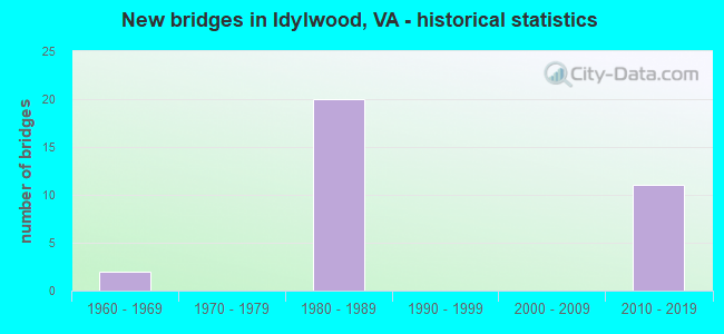
- New bridges - historical statistics
- 21960-1969
- 201980-1989
- 112010-2019


- Bridge Condition - Deck
- 50.0%Good
- 50.0%Satisfactory

- Bridge Condition - Superstructure
- 10.0%Very good
- 10.0%Good
- 80.0%Satisfactory

- Bridge Condition - Substructure
- 10.0%Very good
- 10.0%Good
- 70.0%Satisfactory
- 10.0%Fair

- Bridge Condition - Channel
- 33.3%Very good
- 33.3%Satisfactory
- 33.3%Fair

- Bridge Condition - Culverts
- 66.7%Satisfactory
- 33.3%Fair
Find on map >> Show street view
Structure Number: 6251, Location: 00.10FR703/00.20TO7 (Lat: 38.899883, Lng: -77.191800), Route carried "on" structure: ServiceState highway 7, Year Built: 1984, Status: Open, Structure Length: 3.47m (11.38ft), Average Daily Traffic: 41,576 (year 2008), Truck Traffic: 1%, Average Future Daily Traffic: 65,000 (year 2035), Design Load: HS 20, Features Intersected: INBOUND ROADWAY, Facility Carried by Structure: OUTBOUND ROADWAY
Minimum Vertical Clearance: 30+ m (98+ ft), Kilometerpoint: 100.255, Lanes on structure: 1, Lanes under structure: 1, Base Highway Network: Yes, Owner: State Highway Agency, Approaching Roadway Width: 6.1m (20.0ft), Skew: 4 degrees, Material/Design: Steel, Design/Construction: Stringer/Multi-beam, Number Of Spans In Main Unit: 1, Length of Maximum Span: 34.7m (113.8ft), Curb or Sidewalk Widths: Left: 2.0m (6.6ft), Right: 0.2m (0.7ft), Curb-To-Curb Width: 5.5m (18.0ft), Out-to-Out Width: 8.6m (28.2ft)
Condition: Deck: Good, Superstructure: Satisfactory, Substructure: Satisfactory, Operating Rating: 69.2 metric tons, Method Used To Determine Operating Rating: Load and Resistance Factor (LRFR), Inventory Rating: 53.3 metric tons, Method Used To Determine Inventory Rating: Load and Resistance Factor (LRFR), Structural Evaluation: Equal to present minimum criteria, Deck Geometry: High priority of replacement, Underclear: Meets minimum limits, Approach Roadway Alignment: Equal to present desirable criteria, Length Of Structure Improvement: 0.30m (0.98ft), Designated Inspection Frequency: Every 24 months, Inspection Date: May 2020, Bridge Improvement Cost: $50,000, Roadway Improvement Cost: $50,000, Total Project Cost: $120,000 ( Estimate for 2014), Deck Structure Type: Concrete Cast-file-Place, Wearing Surface/Protective System: Wearing Surface: Monolithic Concrete, Deck Protection: Epoxy Coated Reinforcing
Find on map >> Show street view
Structure Number: 6348, Location: 00.35FR7/00.50TO66 (Lat: 38.898078, Lng: -77.196136), Route carried "on" structure: Ramp Interstate 66, Year Built: 1982, Status: Open, Structure Length: 4.45m (14.60ft), Average Daily Traffic: 4,646 (year 2020), Truck Traffic: 1%, Average Future Daily Traffic: 5,111 (year 2040), Design Load: HS 20, Features Intersected: LEESBURG PIKE & RTE. 7
Minimum Vertical Clearance: 30+ m (98+ ft), Kilometerpoint: 0.386, Lanes on structure: 2, Lanes under structure: 4, Base Highway Network: Yes, Owner: State Highway Agency, Approaching Roadway Width: 11.0m (36.1ft), Material/Design: Steel, Design/Construction: Stringer/Multi-beam, Number Of Spans In Main Unit: 2, Length of Maximum Span: 21.9m (71.9ft), Curb-To-Curb Width: 9.4m (30.8ft), Out-to-Out Width: 10.4m (34.1ft)
Condition: Deck: Good, Superstructure: Satisfactory, Substructure: Satisfactory, Operating Rating: 89.8 metric tons, Method Used To Determine Operating Rating: Load and Resistance Factor (LRFR), Inventory Rating: 70.1 metric tons, Method Used To Determine Inventory Rating: Load and Resistance Factor (LRFR), Structural Evaluation: Equal to present minimum criteria, Deck Geometry: Somewhat better than minimum adequacy, Underclear: Equal to present minimum criteria, Approach Roadway Alignment: Better than present minimum criteria, Length Of Structure Improvement: 4.45m (14.60ft), Designated Inspection Frequency: Every 24 months, Inspection Date: January 2021, Bridge Improvement Cost: $200,000, Roadway Improvement Cost: $20,000, Total Project Cost: $222,000 ( Estimate for 2015), Deck Structure Type: Concrete Cast-file-Place, Wearing Surface/Protective System: Wearing Surface: Monolithic Concrete, Deck Protection: Epoxy Coated Reinforcing
Find on map >> Show street view
Structure Number: 6355, Location: 00.10FR495/01.38T07 (Lat: 38.887939, Lng: -77.217744), Route carried "on" structure: Interstate 66, Year Built: 1982, Status: Open, Structure Length: 0.76m (2.49ft), Average Daily Traffic: 64,785 (year 2020), Truck Traffic: 1%, Average Future Daily Traffic: 90,699 (year 2040), Design Load: HS 20, Features Intersected: HOLMES RUN
Minimum Vertical Clearance: 30+ m (98+ ft), Kilometerpoint: 105.138, Lanes on structure: 3, Base Highway Network: Yes, Owner: State Highway Agency, Approaching Roadway Width: 17.1m (56.1ft), Skew: 3 degrees, Material/Design: Concrete, Design/Construction: Culvert, Number Of Spans In Main Unit: 3, Length of Maximum Span: 2.4m (7.9ft)
Condition: Channel: Fair, Culverts: Fair, Operating Rating: 89.8 metric tons, Method Used To Determine Operating Rating: Load Factor (LF), Inventory Rating: 89.8 metric tons, Method Used To Determine Inventory Rating: Load Factor (LF), Structural Evaluation: Somewhat better than minimum adequacy, Waterway Adequacy: Equal to present minimum criteria, Approach Roadway Alignment: Better than present minimum criteria, Length Of Structure Improvement: 9.85m (32.32ft), Designated Inspection Frequency: Every 24 months, Inspection Date: June 2021, Bridge Improvement Cost: $45,000, Roadway Improvement Cost: $55,000, Total Project Cost: $125,000 ( Estimate for 2015)
Find on map >> Show street view
Structure Number: 6356, Location: 01.46FR495 & 02.24TO29 (Lat: 38.898806, Lng: -77.197414), Route carried "on" structure: Interstate 66, Year Built: 1982, Status: Open, Structure Length: 4.36m (14.30ft), Average Daily Traffic: 21,976 (year 2020), Truck Traffic: 1%, Average Future Daily Traffic: 30,766 (year 2040), Design Load: HS 20+Mod, Features Intersected: LEESBURG PIKE & RTE.7, Facility Carried by Structure: CUSTIS MEM. PKWY.
Minimum Vertical Clearance: 30+ m (98+ ft), Kilometerpoint: 107.304, Lanes on structure: 3, Lanes under structure: 6, Base Highway Network: Yes, Owner: State Highway Agency, Approaching Roadway Width: 18.3m (60.0ft), Skew: 1 degrees, Material/Design: Steel, Design/Construction: Stringer/Multi-beam, Number Of Spans In Main Unit: 2, Length of Maximum Span: 21.6m (70.9ft), Curb or Sidewalk Widths: Left: 0.2m (0.7ft), Right: 0.2m (0.7ft), Curb-To-Curb Width: 16.9m (55.4ft), Out-to-Out Width: 17.9m (58.7ft)
Condition: Deck: Satisfactory, Superstructure: Satisfactory, Substructure: Fair, Operating Rating: 62.6 metric tons, Method Used To Determine Operating Rating: Load and Resistance Factor (LRFR), Inventory Rating: 48.1 metric tons, Method Used To Determine Inventory Rating: Load and Resistance Factor (LRFR), Structural Evaluation: Somewhat better than minimum adequacy, Deck Geometry: Equal to present minimum criteria, Underclear: High priority of corrective action, Approach Roadway Alignment: Equal to present desirable criteria, Length Of Structure Improvement: 4.36m (14.30ft), Designated Inspection Frequency: Every 24 months, Inspection Date: January 2021, Bridge Improvement Cost: $88,000, Roadway Improvement Cost: $175,000, Total Project Cost: $300,000, Deck Structure Type: Concrete Cast-file-Place, Wearing Surface/Protective System: Wearing Surface: Monolithic Concrete, Deck Protection: Epoxy Coated Reinforcing
Find on map >> Show street view
Structure Number: 6362, Location: 01.40FR495/00.10TO7 (Lat: 38.897983, Lng: -77.198800), Route carried "on" structure: Interstate 66, Year Built: 1982, Status: Open, Structure Length: 2.16m (7.09ft), Average Daily Traffic: 21,976 (year 2020), Truck Traffic: 1%, Average Future Daily Traffic: 30,766 (year 2040), Design Load: HS 20, Features Intersected: RAMP A OF I-66WBL
Minimum Vertical Clearance: 30+ m (98+ ft), Kilometerpoint: 107.159, Lanes on structure: 2, Lanes under structure: 1, Base Highway Network: Yes, Owner: State Highway Agency, Approaching Roadway Width: 15.2m (49.9ft), Skew: 1 degrees, Material/Design: Steel, Design/Construction: Stringer/Multi-beam, Number Of Spans In Main Unit: 1, Length of Maximum Span: 21.6m (70.9ft), Curb-To-Curb Width: 13.2m (43.3ft), Out-to-Out Width: 14.2m (46.6ft)
Condition: Deck: Good, Superstructure: Satisfactory, Substructure: Satisfactory, Operating Rating: 69.7 metric tons, Method Used To Determine Operating Rating: Load and Resistance Factor (LRFR), Inventory Rating: 53.7 metric tons, Method Used To Determine Inventory Rating: Load and Resistance Factor (LRFR), Structural Evaluation: Equal to present minimum criteria, Deck Geometry: Superior to present desirable criteria, Underclear: Superior to present desirable criteria, Approach Roadway Alignment: Equal to present desirable criteria, Length Of Structure Improvement: 0.61m (2.00ft), Designated Inspection Frequency: Every 24 months, Inspection Date: January 2021, Bridge Improvement Cost: $100,000, Roadway Improvement Cost: $100,000, Total Project Cost: $210,000 ( Estimate for 2015), Deck Structure Type: Concrete Cast-file-Place, Wearing Surface/Protective System: Wearing Surface: Monolithic Concrete, Deck Protection: Epoxy Coated Reinforcing
Find on map >> Show street view
Structure Number: 6364, Location: 01.46FR495/02.24TO29 (Lat: 38.898561, Lng: -77.197025), Route carried "on" structure: Interstate 66, Year Built: 1982, Status: Open, Structure Length: 4.42m (14.50ft), Average Daily Traffic: 19,914 (year 2020), Truck Traffic: 1%, Average Future Daily Traffic: 27,880 (year 2040), Design Load: HS 20, Features Intersected: LEESBURG PIKE & RTE.7, Facility Carried by Structure: CUSTIS MEM.PKWY.
Minimum Vertical Clearance: 30+ m (98+ ft), Kilometerpoint: 106.789, Lanes on structure: 2, Lanes under structure: 6, Base Highway Network: Yes, Owner: State Highway Agency, Approaching Roadway Width: 18.3m (60.0ft), Skew: 1 degrees, Material/Design: Steel, Design/Construction: Stringer/Multi-beam, Number Of Spans In Main Unit: 2, Length of Maximum Span: 22.3m (73.2ft), Curb-To-Curb Width: 13.2m (43.3ft), Out-to-Out Width: 14.2m (46.6ft)
Condition: Deck: Satisfactory, Superstructure: Satisfactory, Substructure: Satisfactory, Operating Rating: 68.2 metric tons, Method Used To Determine Operating Rating: Load and Resistance Factor (LRFR), Inventory Rating: 52.6 metric tons, Method Used To Determine Inventory Rating: Load and Resistance Factor (LRFR), Structural Evaluation: Equal to present minimum criteria, Deck Geometry: Superior to present desirable criteria, Underclear: Better than present minimum criteria, Approach Roadway Alignment: Equal to present desirable criteria, Length Of Structure Improvement: 1.52m (4.99ft), Designated Inspection Frequency: Every 24 months, Inspection Date: January 2021, Bridge Improvement Cost: $100,000, Roadway Improvement Cost: $100,000, Total Project Cost: $205,000 ( Estimate for 2015), Deck Structure Type: Concrete Cast-file-Place, Wearing Surface/Protective System: Wearing Surface: Monolithic Concrete, Deck Protection: Epoxy Coated Reinforcing
Find on map >> Show street view
Structure Number: 6366, Location: 01.40FR495/00.10TO7 (Lat: 38.897786, Lng: -77.198375), Route carried "on" structure: Interstate 66, Year Built: 1982, Status: Open, Structure Length: 2.32m (7.61ft), Average Daily Traffic: 19,914 (year 2020), Truck Traffic: 1%, Average Future Daily Traffic: 27,880 (year 2040), Design Load: HS 20, Features Intersected: RAMP A OF I-66
Minimum Vertical Clearance: 30+ m (98+ ft), Kilometerpoint: 106.789, Lanes on structure: 2, Lanes under structure: 1, Base Highway Network: Yes, Owner: State Highway Agency, Approaching Roadway Width: 15.2m (49.9ft), Skew: 2 degrees, Material/Design: Steel, Design/Construction: Stringer/Multi-beam, Number Of Spans In Main Unit: 1, Length of Maximum Span: 23.2m (76.1ft), Curb-To-Curb Width: 13.2m (43.3ft), Out-to-Out Width: 14.2m (46.6ft)
Condition: Deck: Satisfactory, Superstructure: Satisfactory, Substructure: Satisfactory, Operating Rating: 65.2 metric tons, Method Used To Determine Operating Rating: Load and Resistance Factor (LRFR), Inventory Rating: 50.3 metric tons, Method Used To Determine Inventory Rating: Load and Resistance Factor (LRFR), Structural Evaluation: Equal to present minimum criteria, Deck Geometry: Superior to present desirable criteria, Underclear: Equal to present minimum criteria, Approach Roadway Alignment: Equal to present desirable criteria, Length Of Structure Improvement: 2.32m (7.61ft), Designated Inspection Frequency: Every 24 months, Inspection Date: January 2021, Bridge Improvement Cost: $93,000, Roadway Improvement Cost: $176,000, Total Project Cost: $300,000 ( Estimate for 2015), Deck Structure Type: Concrete Cast-file-Place, Wearing Surface/Protective System: Wearing Surface: Monolithic Concrete, Deck Protection: Epoxy Coated Reinforcing
Find on map >> Show street view
Structure Number: 6871, Location: 00.17 947 / 00.25 29 (Lat: 38.879125, Lng: -77.220656), Route carried "on" structure: County highway 703, Year Built: 1963, Status: Open, Structure Length: 0.64m (2.10ft), Average Daily Traffic: 6,083 (year 2020), Truck Traffic: 1%, Average Future Daily Traffic: 8,516 (year 2040), Design Load: HS 20, Features Intersected: HOLMES RUN, Facility Carried by Structure: SHREVE ROAD
Minimum Vertical Clearance: 30+ m (98+ ft), Kilometerpoint: 0.402, Lanes on structure: 2, Owner: State Highway Agency, Approaching Roadway Width: 6.7m (22.0ft), Skew: 2 degrees, Material/Design: Concrete, Design/Construction: Culvert, Number Of Spans In Main Unit: 2, Length of Maximum Span: 3.0m (9.8ft)
Condition: Channel: Satisfactory, Culverts: Satisfactory, Operating Rating: 73.5 metric tons, Method Used To Determine Operating Rating: Load Factor (LF), Inventory Rating: 43.5 metric tons, Method Used To Determine Inventory Rating: Load Factor (LF), Structural Evaluation: Equal to present minimum criteria, Waterway Adequacy: Better than present minimum criteria, Approach Roadway Alignment: Better than present minimum criteria, Designated Inspection Frequency: Every 24 months, Inspection Date: April 2021, Bridge Improvement Cost: $21,000, Roadway Improvement Cost: $5,000, Total Project Cost: $30,000
Find on map >> Show street view
Structure Number: 6878, Location: 00.12FR.1117/00.18TO2085 (Lat: 38.890731, Lng: -77.210111), Route carried "on" structure: County highway 719, Year Built: 1981, Status: Open, Structure Length: 7.16m (23.49ft), Average Daily Traffic: 2,511 (year 2020), Truck Traffic: 2%, Average Future Daily Traffic: 3,515 (year 2040), Design Load: HS 20, Features Intersected: ROUTE I66 & METRO, Facility Carried by Structure: VIRGINA LANE
Minimum Vertical Clearance: 30+ m (98+ ft), Kilometerpoint: 0.917, Lanes on structure: 2, Lanes under structure: 5, Owner: State Highway Agency, Approaching Roadway Width: 8.8m (28.9ft), Skew: 1 degrees, Material/Design: Steel continuous, Design/Construction: Stringer/Multi-beam, Number Of Spans In Main Unit: 3, Length of Maximum Span: 28.3m (92.8ft), Curb or Sidewalk Widths: Left: 3.0m (9.8ft), Right: 0.2m (0.7ft), Curb-To-Curb Width: 8.7m (28.5ft), Out-to-Out Width: 13.0m (42.7ft)
Condition: Deck: Satisfactory, Superstructure: Satisfactory, Substructure: Satisfactory, Operating Rating: 76.2 metric tons, Method Used To Determine Operating Rating: Load and Resistance Factor (LRFR), Inventory Rating: 58.8 metric tons, Method Used To Determine Inventory Rating: Load and Resistance Factor (LRFR), Structural Evaluation: Equal to present minimum criteria, Deck Geometry: Meets minimum limits, Underclear: Equal to present minimum criteria, Approach Roadway Alignment: Equal to present desirable criteria, Length Of Structure Improvement: 3.05m (10.01ft), Designated Inspection Frequency: Every 24 months, Inspection Date: July 2021, Bridge Improvement Cost: $10,000, Roadway Improvement Cost: $10,000, Total Project Cost: $25,000 ( Estimate for 2015), Deck Structure Type: Concrete Cast-file-Place, Wearing Surface/Protective System: Wearing Surface: Monolithic Concrete, Deck Protection: Epoxy Coated Reinforcing
Find on map >> Show street view
Structure Number: 6966, Location: 00.06FR2044/00.10TO2046 (Lat: 38.895942, Lng: -77.201119), Route carried "on" structure: County highway 2793, Year Built: 1981, Status: Open, Structure Length: 6.80m (22.31ft), Average Daily Traffic: 1,050 (year 2002), Average Future Daily Traffic: 1,250 (year 2040), Design Load: HS 20, Features Intersected: I-66 & METRO, Facility Carried by Structure: BARBOUR ROAD
Minimum Vertical Clearance: 30+ m (98+ ft), Kilometerpoint: 0.434, Lanes on structure: 2, Lanes under structure: 5, Owner: State Highway Agency, Approaching Roadway Width: 7.9m (25.9ft), Material/Design: Steel continuous, Design/Construction: Stringer/Multi-beam, Number Of Spans In Main Unit: 3, Length of Maximum Span: 28.0m (91.9ft), Curb or Sidewalk Widths: Left: 1.5m (4.9ft), Right: 1.5m (4.9ft), Curb-To-Curb Width: 7.9m (25.9ft), Out-to-Out Width: 11.6m (38.1ft)
Condition: Deck: Satisfactory, Superstructure: Satisfactory, Substructure: Satisfactory, Operating Rating: 64.9 metric tons, Method Used To Determine Operating Rating: Load and Resistance Factor (LRFR), Inventory Rating: 50.1 metric tons, Method Used To Determine Inventory Rating: Load and Resistance Factor (LRFR), Structural Evaluation: Equal to present minimum criteria, Deck Geometry: Meets minimum limits, Underclear: Somewhat better than minimum adequacy, Approach Roadway Alignment: Equal to present desirable criteria, Length Of Structure Improvement: 6.80m (22.31ft), Designated Inspection Frequency: Every 24 months, Inspection Date: July 2021, Bridge Improvement Cost: $44,000, Roadway Improvement Cost: $76,000, Total Project Cost: $125,000 ( Estimate for 2015), Deck Structure Type: Concrete Cast-file-Place, Wearing Surface/Protective System: Deck Protection: Epoxy Coated Reinforcing
Find on map >> Show street view
Structure Number: 6981, Location: 00.00FR.3470/00.03TO5040 (Lat: 38.877917, Lng: -77.210869), Route carried "on" structure: County highway 3469, Year Built: 1968, Status: Posted for load, Structure Length: 0.70m (2.30ft), Average Daily Traffic: 409 (year 2016), Average Future Daily Traffic: 415 (year 2040), Design Load: HS 20, Features Intersected: BRANCH OF HOLMES RUN, Facility Carried by Structure: MARY STREET
Minimum Vertical Clearance: 30+ m (98+ ft), Kilometerpoint: 0.306, Lanes on structure: 2, Owner: State Highway Agency, Approaching Roadway Width: 7.9m (25.9ft), Skew: 2 degrees, Material/Design: Steel, Design/Construction: Culvert, Number Of Spans In Main Unit: 2, Length of Maximum Span: 2.7m (8.9ft)
Condition: Channel: Very good, Culverts: Satisfactory, Operating Rating: 36.3 metric tons, Method Used To Determine Operating Rating: Load Factor (LF), Inventory Rating: 32.7 metric tons, Method Used To Determine Inventory Rating: Load Factor (LF), Structural Evaluation: Equal to present minimum criteria, Waterway Adequacy: Equal to present minimum criteria, Approach Roadway Alignment: Equal to present minimum criteria, Length Of Structure Improvement: 4.15m (13.62ft), Designated Inspection Frequency: Every 24 months, Inspection Date: June 2020, Bridge Improvement Cost: $55,000, Roadway Improvement Cost: $99,000, Total Project Cost: $250,000
Find on map >> Show street view
Structure Number: 28667, Location: 0.15fr66WB & .25to495S (Lat: 38.890083, Lng: -77.217444), Route carried "on" structure: Ramp Interstate 66, Year Built: 2012, Status: Open, Structure Length: 16.95m (55.61ft), Average Daily Traffic: 6,919 (year 2020), Truck Traffic: 3%, Average Future Daily Traffic: 9,687 (year 2040), Design Load: HS 20, Features Intersected: 495 MAIN; HOT & 66 RAMPS
Minimum Vertical Clearance: 30.18m (99.02ft), Kilometerpoint: 0.000, Lanes on structure: 1, Lanes under structure: 15, Base Highway Network: Yes, Owner: State Highway Agency, Approaching Roadway Width: 9.4m (30.8ft), Material/Design: Steel continuous, Design/Construction: Stringer/Multi-beam, Number Of Spans In Main Unit: 4, Length of Maximum Span: 53.3m (174.9ft), Curb-To-Curb Width: 7.0m (23.0ft), Out-to-Out Width: 11.3m (37.1ft)
Condition: Deck: Good, Superstructure: Good, Substructure: Very good, Operating Rating: 68.9 metric tons, Method Used To Determine Operating Rating: Load and Resistance Factor (LRFR), Inventory Rating: 53.5 metric tons, Method Used To Determine Inventory Rating: Load and Resistance Factor (LRFR), Structural Evaluation: Better than present minimum criteria, Deck Geometry: Equal to present minimum criteria, Underclear: High priority of corrective action, Approach Roadway Alignment: Equal to present desirable criteria, Length Of Structure Improvement: 0.30m (0.98ft), Designated Inspection Frequency: Every 24 months, Critical Feature Inspection Frequency: Every 24 months, Inspection Date: March 2020, Critical Feature Inspection Date: March 2020, Bridge Improvement Cost: $1,000, Roadway Improvement Cost: $1,000, Total Project Cost: $3,000 ( Estimate for 2015), Deck Structure Type: Concrete Cast-file-Place, Wearing Surface/Protective System: Wearing Surface: Monolithic Concrete, Deck Protection: Epoxy Coated Reinforcing
Find on map >> Show street view
Structure Number: 28677, Location: 0.0FR/0.0TO (Lat: 38.889781, Lng: -77.217669), Route carried "on" structure: Ramp Interstate 66, Year Built: 2012, Status: Open, Structure Length: 10.76m (35.30ft), Average Daily Traffic: 39,139 (year 2018), Truck Traffic: 1%, Average Future Daily Traffic: 91,486 (year 2035), Design Load: HS 20, Features Intersected: I-495 HOT; I-66 RAMPS
Minimum Vertical Clearance: 6.10m (20.01ft), Kilometerpoint: 0.000, Lanes on structure: 1, Lanes under structure: 10, Base Highway Network: Yes, Toll: On toll road, Owner: State Highway Agency, Maintenance Responsibility: Private, Approaching Roadway Width: 9.1m (29.9ft), Material/Design: Concrete, Design/Construction: Slab, Number Of Spans In Main Unit: 2, Number Of Approach Spans: 2, Length of Maximum Span: 56.4m (185.0ft), Curb or Sidewalk Widths: Left: 0.5m (1.6ft), Right: 0.5m (1.6ft), Curb-To-Curb Width: 7.3m (24.0ft), Out-to-Out Width: 9.3m (30.5ft)
Condition: Deck: Good, Superstructure: Very good, Substructure: Good, Operating Rating: 88.0 metric tons, Method Used To Determine Operating Rating: Load and Resistance Factor (LRFR), Inventory Rating: 68.0 metric tons, Method Used To Determine Inventory Rating: Load and Resistance Factor (LRFR), Structural Evaluation: Better than present minimum criteria, Deck Geometry: Better than present minimum criteria, Underclear: Equal to present minimum criteria, Approach Roadway Alignment: Equal to present desirable criteria, Length Of Structure Improvement: 3.05m (10.01ft), Designated Inspection Frequency: Every 24 months, Inspection Date: September 2020, Bridge Improvement Cost: $1,000, Roadway Improvement Cost: $1,000, Total Project Cost: $3,000 ( Estimate for 2016), Deck Structure Type: Concrete Cast-file-Place, Wearing Surface/Protective System: Wearing Surface: Monolithic Concrete, Deck Protection: Epoxy Coated Reinforcing
Find on map >> Show street view
Structure Number: 6251, Location: 00.10FR703/00.20TO7 (Lat: 38.899883, Lng: -77.191800), Route carried "under" structure: ServiceState highway 7, Year Built: 1984, Structure Length: 0. m, Average Daily Traffic: 20,400 (year 2008), Truck Traffic: 1%, Features Intersected: INBOUND ROADWAY, Facility Carried by Structure: OUTBOUND ROADWAY
Minimum Vertical Clearance: 5.89m (19.32ft), Kilometerpoint: 117.055, Lanes on structure: 1, Lanes under structure: 1, Material/Design: Steel, Design/Construction: Stringer/Multi-beam, Length of Maximum Span: 34.7m (113.8ft)
Find on map >> Show street view
Structure Number: 6348, Location: 00.35FR7/00.50TO66 (Lat: 38.898078, Lng: -77.196136), Route carried "under" structure: State highway 7, Year Built: 1982, Structure Length: 0. m, Average Daily Traffic: 41,576 (year 2008), Truck Traffic: 1%, Features Intersected: LEESBURG PIKE & RTE. 7, Facility Carried by Structure: RAMP A OF I-66EB
Minimum Vertical Clearance: 5.13m (16.83ft), Kilometerpoint: 100.032, Lanes on structure: 2, Lanes under structure: 4, Material/Design: Steel, Design/Construction: Stringer/Multi-beam, Length of Maximum Span: 21.9m (71.9ft)
Find on map >> Show street view
Structure Number: 6356, Location: 01.46FR495 & 02.24TO29 (Lat: 38.898806, Lng: -77.197414), Route carried "under" structure: State highway 7, Year Built: 1982, Structure Length: 0. m, Average Daily Traffic: 41,576 (year 2008), Truck Traffic: 1%, Features Intersected: LEESBURG PIKE & RTE.7, Facility Carried by Structure: CUSTIS MEM. PKWY.
Minimum Vertical Clearance: 5.69m (18.67ft), Kilometerpoint: 99.919, Lanes on structure: 3, Lanes under structure: 6, Material/Design: Steel, Design/Construction: Stringer/Multi-beam, Length of Maximum Span: 21.6m (70.9ft)
Find on map >> Show street view
Structure Number: 6362, Location: 01.40FR495/00.10TO7 (Lat: 38.897983, Lng: -77.198800), Route carried "under" structure: Ramp State highway 7, Year Built: 1982, Structure Length: 0. m, Average Daily Traffic: 9,000 (year 1994), Features Intersected: RAMP A OF I-66WBL, Facility Carried by Structure: I-66WBL
Minimum Vertical Clearance: 6.75m (22.15ft), Kilometerpoint: 0.161, Lanes on structure: 2, Lanes under structure: 1, Material/Design: Steel, Design/Construction: Stringer/Multi-beam, Length of Maximum Span: 21.6m (70.9ft)
Find on map >> Show street view
Structure Number: 6364, Location: 01.46FR495/02.24TO29 (Lat: 38.898561, Lng: -77.197025), Route carried "under" structure: State highway 7, Year Built: 1982, Structure Length: 0. m, Average Daily Traffic: 41,576 (year 2008), Truck Traffic: 1%, Features Intersected: LEESBURG PIKE & RTE.7, Facility Carried by Structure: CUSTIS MEM.PKWY.
Minimum Vertical Clearance: 6.05m (19.85ft), Kilometerpoint: 99.983, Lanes on structure: 2, Lanes under structure: 3, Material/Design: Steel, Design/Construction: Stringer/Multi-beam, Length of Maximum Span: 22.3m (73.2ft)
Find on map >> Show street view
Structure Number: 6364, Location: 01.46FR495/02.24TO29 (Lat: 38.898561, Lng: -77.197025), Route carried "under" structure: State highway 7, Year Built: 1982, Structure Length: 0. m, Average Daily Traffic: 41,576 (year 2008), Truck Traffic: 1%, Features Intersected: LEESBURG PIKE & RTE.7, Facility Carried by Structure: CUSTIS MEM.PKWY.
Minimum Vertical Clearance: 5.31m (17.42ft), Kilometerpoint: 99.983, Lanes on structure: 2, Lanes under structure: 3, Material/Design: Steel, Design/Construction: Stringer/Multi-beam, Length of Maximum Span: 22.3m (73.2ft)
Find on map >> Show street view
Structure Number: 6366, Location: 01.40FR495/00.10TO7 (Lat: 38.897786, Lng: -77.198375), Route carried "under" structure: Ramp Interstate 7, Year Built: 1982, Structure Length: 0. m, Average Daily Traffic: 9,000 (year 1994), Features Intersected: RAMP A OF I-66, Facility Carried by Structure: I-66 EBL
Minimum Vertical Clearance: 5.46m (17.91ft), Kilometerpoint: 0.257, Lanes on structure: 2, Lanes under structure: 1, Material/Design: Steel, Design/Construction: Stringer/Multi-beam, Length of Maximum Span: 23.2m (76.1ft)
Find on map >> Show street view
Structure Number: 6878, Location: 00.12FR.1117/00.18TO2085 (Lat: 38.890731, Lng: -77.210111), Route carried "under" structure: Interstate 66, Year Built: 1981, Structure Length: 0. m, Average Daily Traffic: 91,554 (year 1994), Features Intersected: ROUTE I66 & METRO, Facility Carried by Structure: VIRGINA LANE
Minimum Vertical Clearance: 5.26m (17.26ft), Kilometerpoint: 105.583, Lanes on structure: 2, Lanes under structure: 2, Material/Design: Steel continuous, Design/Construction: Stringer/Multi-beam, Length of Maximum Span: 28.3m (92.8ft)
Find on map >> Show street view
Structure Number: 6878, Location: 00.12FR.1117/00.18TO2085 (Lat: 38.890731, Lng: -77.210111), Route carried "under" structure: Interstate 66, Year Built: 1981, Structure Length: 0. m, Average Daily Traffic: 71,700 (year 2008), Features Intersected: ROUTE I66 & METRO, Facility Carried by Structure: VIRGINA LANE
Minimum Vertical Clearance: 5.18m (16.99ft), Kilometerpoint: 105.229, Lanes on structure: 2, Lanes under structure: 3, Material/Design: Steel continuous, Design/Construction: Stringer/Multi-beam, Length of Maximum Span: 28.3m (92.8ft)
Find on map >> Show street view
Structure Number: 6966, Location: 00.06FR2044/00.10TO2046 (Lat: 38.895942, Lng: -77.201119), Route carried "under" structure: Interstate 66, Year Built: 1981, Structure Length: 0. m, Average Daily Traffic: 75,030 (year 1994), Features Intersected: I-66 & METRO, Facility Carried by Structure: BARBOUR ROAD
Minimum Vertical Clearance: 5.69m (18.67ft), Kilometerpoint: 106.902, Lanes on structure: 2, Lanes under structure: 3, Material/Design: Steel continuous, Design/Construction: Stringer/Multi-beam, Length of Maximum Span: 28.0m (91.9ft)
Find on map >> Show street view
Structure Number: 6966, Location: 00.06FR2044/00.10TO2046 (Lat: 38.895942, Lng: -77.201119), Route carried "under" structure: Interstate 66, Year Built: 1981, Structure Length: 0. m, Average Daily Traffic: 73,701 (year 2008), Features Intersected: I-66 & METRO, Facility Carried by Structure: BARBOUR ROAD
Minimum Vertical Clearance: 5.05m (16.57ft), Kilometerpoint: 106.902, Lanes on structure: 2, Lanes under structure: 2, Material/Design: Steel continuous, Design/Construction: Stringer/Multi-beam, Length of Maximum Span: 28.0m (91.9ft)
Find on map >> Show street view
Structure Number: 28667, Location: 0.15fr66WB & .25to495S (Lat: 38.890083, Lng: -77.217444), Route carried "under" structure: Interstate 495, Year Built: 2012, Structure Length: 0. m, Average Daily Traffic: 75,000 (year 2011), Truck Traffic: 15%, Features Intersected: 495 MAIN; HOT & 66 RAMPS, Facility Carried by Structure: 66 RAMP ES
Minimum Vertical Clearance: 8.66m (28.41ft), Kilometerpoint: 0.000, Lanes on structure: 1, Lanes under structure: 5, Material/Design: Steel continuous, Design/Construction: Stringer/Multi-beam, Length of Maximum Span: 53.3m (174.9ft)
Find on map >> Show street view
Structure Number: 28667, Location: 0.15fr66WB & .25to495S (Lat: 38.890083, Lng: -77.217444), Route carried "under" structure: Interstate 495, Year Built: 2012, Structure Length: 0. m, Average Daily Traffic: 45,000 (year 2011), Truck Traffic: 6%, Features Intersected: 495 MAIN; HOT & 66 RAMPS, Facility Carried by Structure: 66 RAMP ES
Minimum Vertical Clearance: 8.71m (28.58ft), Kilometerpoint: 0.000, Lanes on structure: 1, Lanes under structure: 2, Material/Design: Steel continuous, Design/Construction: Stringer/Multi-beam, Length of Maximum Span: 53.3m (174.9ft)
Find on map >> Show street view
Structure Number: 28667, Location: 0.15fr66WB & .25to495S (Lat: 38.890083, Lng: -77.217444), Route carried "under" structure: Alternate Interstate 495, Year Built: 2012, Structure Length: 0. m, Average Daily Traffic: 25,000 (year 2011), Features Intersected: 495 MAIN; HOT & 66 RAMPS, Facility Carried by Structure: 66 RAMP ES
Minimum Vertical Clearance: 8.99m (29.49ft), Kilometerpoint: 0.000, Lanes on structure: 1, Lanes under structure: 1, Material/Design: Steel continuous, Design/Construction: Stringer/Multi-beam, Length of Maximum Span: 53.3m (174.9ft)
Find on map >> Show street view
Structure Number: 28667, Location: 0.15fr66WB & .25to495S (Lat: 38.890083, Lng: -77.217444), Route carried "under" structure: Alternate Interstate 495, Year Built: 2012, Structure Length: 0. m, Average Daily Traffic: 23,000 (year 2011), Features Intersected: 495 MAIN; HOT & 66 RAMPS, Facility Carried by Structure: 66 RAMP ES
Minimum Vertical Clearance: 7.87m (25.82ft), Kilometerpoint: 0.000, Lanes on structure: 1, Lanes under structure: 1, Material/Design: Steel continuous, Design/Construction: Stringer/Multi-beam, Length of Maximum Span: 53.3m (174.9ft)
Find on map >> Show street view
Structure Number: 28667, Location: 0.15fr66WB & .25to495S (Lat: 38.890083, Lng: -77.217444), Route carried "under" structure: Interstate 495, Year Built: 2012, Structure Length: 0. m, Average Daily Traffic: 65,000 (year 2011), Truck Traffic: 8%, Features Intersected: 495 MAIN; HOT & 66 RAMPS, Facility Carried by Structure: 66 RAMP ES
Minimum Vertical Clearance: 5.28m (17.32ft), Kilometerpoint: 0.000, Lanes on structure: 1, Lanes under structure: 2, Material/Design: Steel continuous, Design/Construction: Stringer/Multi-beam, Length of Maximum Span: 53.3m (174.9ft)
Find on map >> Show street view
Structure Number: 28667, Location: 0.15fr66WB & .25to495S (Lat: 38.890083, Lng: -77.217444), Route carried "under" structure: Interstate 495, Year Built: 2012, Structure Length: 0. m, Average Daily Traffic: 68,000 (year 2011), Truck Traffic: 6%, Features Intersected: 495 MAIN; HOT & 66 RAMPS, Facility Carried by Structure: 66 RAMP ES
Minimum Vertical Clearance: 5.77m (18.93ft), Kilometerpoint: 0.000, Lanes on structure: 1, Lanes under structure: 4, Material/Design: Steel continuous, Design/Construction: Stringer/Multi-beam, Length of Maximum Span: 53.3m (174.9ft)
Find on map >> Show street view
Structure Number: 28677, Location: 0.0FR/0.0TO (Lat: 38.889781, Lng: -77.217669), Route carried "under" structure: Interstate 495, Year Built: 2012, Structure Length: 0. m, Average Daily Traffic: 45,000 (year 2012), Truck Traffic: 6%, Features Intersected: I-495 HOT; I-66 RAMPS, Facility Carried by Structure: 66 RAMP ESH
Minimum Vertical Clearance: 6.76m (22.18ft), Kilometerpoint: 0.000, Lanes on structure: 1, Lanes under structure: 7, Toll: On toll road, Material/Design: Concrete, Design/Construction: Slab, Length of Maximum Span: 56.4m (185.0ft)
Find on map >> Show street view
Structure Number: 28677, Location: 0.0FR/0.0TO (Lat: 38.889781, Lng: -77.217669), Route carried "under" structure: Ramp Interstate 495, Year Built: 2012, Structure Length: 0. m, Average Daily Traffic: 30,000 (year 2012), Truck Traffic: 3%, Features Intersected: I-495 HOT; I-66 RAMPS, Facility Carried by Structure: 66 RAMP ESH
Minimum Vertical Clearance: 6.30m (20.67ft), Kilometerpoint: 0.000, Lanes on structure: 1, Lanes under structure: 1, Material/Design: Concrete, Design/Construction: Slab, Length of Maximum Span: 56.4m (185.0ft)
Find on map >> Show street view
Structure Number: 28677, Location: 0.0FR/0.0TO (Lat: 38.889781, Lng: -77.217669), Route carried "under" structure: Ramp Interstate 495, Year Built: 2012, Structure Length: 0. m, Average Daily Traffic: 30,000 (year 2012), Truck Traffic: 2%, Features Intersected: I-495 HOT; I-66 RAMPS, Facility Carried by Structure: 66 RAMP ESH
Minimum Vertical Clearance: 7.24m (23.75ft), Kilometerpoint: 0.000, Lanes on structure: 1, Lanes under structure: 1, Toll: On toll road, Material/Design: Concrete, Design/Construction: Slab, Length of Maximum Span: 56.4m (185.0ft)