Bridge Statistics for Hillburn, New York (NY)
Condition, Traffic, Stress, Structural Evaluation, Project Costs
- National Bridge Inventory (NBI) Statistics
- 14Number of bridges
- 236ft / 71.8mTotal length
- $119,259,000Total costs
- 336,093Total average daily traffic
- 31,666Total average daily truck traffic
- National Bridge Inventory (NBI) Registered Bridges for Hillburn
- No street view available for this location
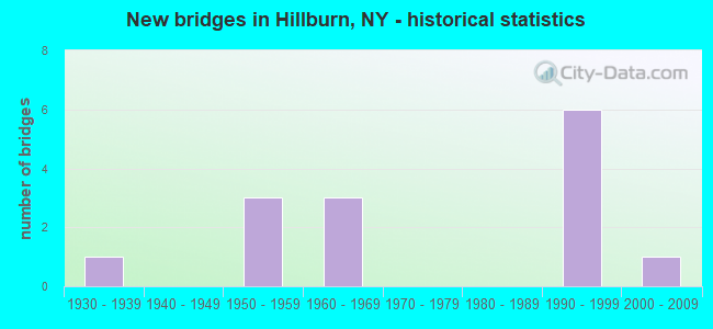
- New bridges - historical statistics
- 11930-1939
- 31950-1959
- 31960-1969
- 61990-1999
- 12000-2009

- Reconstructed bridges - Historical Statistics
- 11980-1989
- 11990-1999
- 02000-2009
- 02010-2019
- 12020-2022


- Bridge Condition - Deck
- 11.1%Very good
- 55.6%Good
- 11.1%Satisfactory
- 22.2%Fair

- Bridge Condition - Superstructure
- 11.1%Very good
- 55.6%Good
- 33.3%Fair

- Bridge Condition - Substructure
- 33.3%Good
- 44.4%Satisfactory
- 11.1%Fair
- 11.1%Poor

- Bridge Condition - Channel
- 25.0%Good
- 25.0%Satisfactory
- 50.0%Fair
Find on map >> Show street view
Structure Number: 102759, Location: .2 MI E JCT SH 59 & SH 17 (Lat: 41.132267, Lng: -74.166844), Route carried "on" structure: State highway 59, Year Built: 2000, Status: Open, Structure Length: 5.03m (16.50ft), Average Daily Traffic: 10,374 (year 2017), Truck Traffic: 8%, Average Future Daily Traffic: 12,602 (year 2040), Design Load: HS 25 or greater, Features Intersected: RAMAPO RIVER
Minimum Vertical Clearance: 30+ m (98+ ft), Kilometerpoint: 0.241, Lanes on structure: 2, Base Highway Network: Yes, Owner: State Highway Agency, Approaching Roadway Width: 11.9m (39.0ft), Skew: 4 degrees, Material/Design: Steel, Design/Construction: Stringer/Multi-beam, Number Of Spans In Main Unit: 1, Length of Maximum Span: 48.4m (158.8ft), Curb-To-Curb Width: 12.0m (39.4ft), Out-to-Out Width: 12.6m (41.3ft)
Condition: Deck: Satisfactory, Superstructure: Good, Substructure: Good, Channel: Good, Operating Rating: 93.4 metric tons, Method Used To Determine Operating Rating: Load Factor (LF), Inventory Rating: 56.2 metric tons, Method Used To Determine Inventory Rating: Load Factor (LF), Structural Evaluation: Better than present minimum criteria, Deck Geometry: Somewhat better than minimum adequacy, Waterway Adequacy: Somewhat better than minimum adequacy, Approach Roadway Alignment: Equal to present desirable criteria, Length Of Structure Improvement: 5.02m (16.47ft), Designated Inspection Frequency: Every 24 months, Inspection Date: September 2021, Bridge Improvement Cost: $2,953,000, Roadway Improvement Cost: $1,729,000, Total Project Cost: $4,682,000 ( Estimate for 2021), Deck Structure Type: Concrete Cast-file-Place, Wearing Surface/Protective System: Wearing Surface: Integral Concrete, Deck Protection: Epoxy Coated Reinforcing
Find on map >> Show street view
Structure Number: 10276, Location: .4 MI E JCT SH 59 & SH 17 (Lat: 41.129581, Lng: -74.165300), Route carried "on" structure: State highway 59, Year Built: 1932, Year Reconstructed: 2020, Status: Open, Structure Length: 8.08m (26.51ft), Average Daily Traffic: 10,374 (year 2017), Truck Traffic: 8%, Average Future Daily Traffic: 12,602 (year 2040), Design Load: HS 20, Features Intersected: MNRR PJ LINE
Minimum Vertical Clearance: 4.80m (15.75ft), Kilometerpoint: 0.595, Lanes on structure: 2, Base Highway Network: Yes, Owner: State Highway Agency, Approaching Roadway Width: 12.2m (40.0ft), Material/Design: Steel continuous, Design/Construction: Truss - Thru, Number Of Spans In Main Unit: 2, Length of Maximum Span: 39.0m (128.0ft), Curb-To-Curb Width: 12.1m (39.7ft), Out-to-Out Width: 13.0m (42.7ft)
Condition: Deck: Fair, Superstructure: Fair, Substructure: Fair, Operating Rating: 47.6 metric tons, Method Used To Determine Operating Rating: Load and Resistance Factor Rating (LRFR) rating reported by rating factor(RF) method using HL-93 loadings, Inventory Rating: 36.9 metric tons, Method Used To Determine Inventory Rating: Load and Resistance Factor Rating (LRFR) rating reported by rating factor(RF) method using HL-93 loadings, Structural Evaluation: Somewhat better than minimum adequacy, Deck Geometry: Somewhat better than minimum adequacy, Underclear: Somewhat better than minimum adequacy, Approach Roadway Alignment: Meets minimum limits, Length Of Structure Improvement: 8.07m (26.48ft), Designated Inspection Frequency: Every 24 months, Critical Feature Inspection Frequency: Every 24 months, Inspection Date: September 2020, Critical Feature Inspection Date: September 2020, Bridge Improvement Cost: $9,596,000, Roadway Improvement Cost: $5,620,000, Total Project Cost: $15,216,000 ( Estimate for 2021), Deck Structure Type: Concrete Cast-file-Place, Wearing Surface/Protective System: Wearing Surface: Integral Concrete, Deck Protection: Epoxy Coated Reinforcing
Find on map >> Show street view
Structure Number: 334614, Location: 2.6 MI NW OF SUFFERN (Lat: 41.124931, Lng: -74.164664), Route carried "on" structure: Other road , Year Built: 1966, Status: Open, Structure Length: 3.02m (9.91ft), Average Daily Traffic: 1,702 (year 2019), Truck Traffic: 4%, Average Future Daily Traffic: 2,105 (year 2040), Design Load: HS 20, Features Intersected: RAMAPO RIVER, Facility Carried by Structure: FOURTH STREET
Minimum Vertical Clearance: 30+ m (98+ ft), Kilometerpoint: 0.483, Lanes on structure: 2, Owner: County Highway Agency, Approaching Roadway Width: 7.9m (25.9ft), Material/Design: Steel, Design/Construction: Stringer/Multi-beam, Number Of Spans In Main Unit: 1, Length of Maximum Span: 28.9m (94.8ft), Curb or Sidewalk Widths: Left: 1.5m (4.9ft), Right: 1.5m (4.9ft), Curb-To-Curb Width: 7.9m (25.9ft), Out-to-Out Width: 11.6m (38.1ft)
Condition: Deck: Very good, Superstructure: Very good, Substructure: Satisfactory, Channel: Fair, Operating Rating: 64.5 metric tons, Method Used To Determine Operating Rating: Load and Resistance Factor Rating (LRFR) rating reported by rating factor(RF) method using HL-93 loadings, Inventory Rating: 49.9 metric tons, Method Used To Determine Inventory Rating: Load and Resistance Factor Rating (LRFR) rating reported by rating factor(RF) method using HL-93 loadings, Structural Evaluation: Equal to present minimum criteria, Deck Geometry: Meets minimum limits, Waterway Adequacy: Somewhat better than minimum adequacy, Approach Roadway Alignment: Better than present minimum criteria, Length Of Structure Improvement: 3.01m (9.88ft), Designated Inspection Frequency: Every 24 months, Inspection Date: August 2021, Bridge Improvement Cost: $1,490,000, Roadway Improvement Cost: $873,000, Total Project Cost: $2,363,000 ( Estimate for 2021), Deck Structure Type: Concrete Cast-file-Place, Wearing Surface/Protective System: Wearing Surface: Bituminous
Find on map >> Show street view
Structure Number: 334615, Location: 2.5 MI SE OF SLOATSBURG (Lat: 41.125528, Lng: -74.162719), Route carried "on" structure: Other road , Year Built: 1965, Status: Open, Structure Length: 7.86m (25.79ft), Average Daily Traffic: 1,702 (year 2019), Truck Traffic: 4%, Average Future Daily Traffic: 2,105 (year 2040), Design Load: HS 20, Features Intersected: AVON SERVICE ROAD, MNRR, Facility Carried by Structure: FOURTH STREET
Minimum Vertical Clearance: 30+ m (98+ ft), Kilometerpoint: 0.628, Lanes on structure: 2, Lanes under structure: 2, Owner: Railroad, Approaching Roadway Width: 8.5m (27.9ft), Material/Design: Steel, Design/Construction: Stringer/Multi-beam, Number Of Spans In Main Unit: 4, Length of Maximum Span: 25.9m (85.0ft), Curb or Sidewalk Widths: Left: 1.5m (4.9ft), Right: 0.4m (1.3ft), Curb-To-Curb Width: 8.5m (27.9ft), Out-to-Out Width: 11.1m (36.4ft)
Condition: Deck: Good, Superstructure: Fair, Substructure: Satisfactory, Operating Rating: 60.9 metric tons, Method Used To Determine Operating Rating: Load and Resistance Factor Rating (LRFR) rating reported by rating factor(RF) method using HL-93 loadings, Inventory Rating: 47.0 metric tons, Method Used To Determine Inventory Rating: Load and Resistance Factor Rating (LRFR) rating reported by rating factor(RF) method using HL-93 loadings, Structural Evaluation: Somewhat better than minimum adequacy, Deck Geometry: Somewhat better than minimum adequacy, Underclear: Meets minimum limits, Approach Roadway Alignment: Better than present minimum criteria, Length Of Structure Improvement: 7.86m (25.79ft), Designated Inspection Frequency: Every 24 months, Inspection Date: July 2021, Bridge Improvement Cost: $3,320,000, Roadway Improvement Cost: $1,944,000, Total Project Cost: $5,264,000 ( Estimate for 2021), Deck Structure Type: Concrete Cast-file-Place, Wearing Surface/Protective System: Wearing Surface: Integral Concrete
Find on map >> Show street view
Structure Number: 5014079, Location: JCT SH 17 & I87 (Lat: 41.133722, Lng: -74.168292), Route carried "on" structure: Interstate 87, Year Built: 1953, Year Reconstructed: 1994, Status: Open, Structure Length: 3.99m (13.09ft), Average Daily Traffic: 66,391 (year 2019), Truck Traffic: 16%, Average Future Daily Traffic: 112,426 (year 2040), Design Load: HS 20+Mod, Features Intersected: RTE 17
Minimum Vertical Clearance: 30+ m (98+ ft), Kilometerpoint: 26.613, Lanes on structure: 10, Lanes under structure: 2, Base Highway Network: Yes, Toll: On Interstate toll segment, Owner: State Highway Agency, Maintenance Responsibility: State Toll Authority, Approaching Roadway Width: 50.0m (164.0ft), Skew: 26 degrees, Material/Design: Steel, Design/Construction: Stringer/Multi-beam, Number Of Spans In Main Unit: 1, Length of Maximum Span: 38.1m (125.0ft), Curb-To-Curb Width: 49.8m (163.4ft), Out-to-Out Width: 54.0m (177.2ft)
Condition: Deck: Good, Superstructure: Good, Substructure: Satisfactory, Operating Rating: 98.0 metric tons, Method Used To Determine Operating Rating: Load Factor (LF), Inventory Rating: 58.1 metric tons, Method Used To Determine Inventory Rating: Load Factor (LF), Structural Evaluation: Equal to present minimum criteria, Deck Geometry: Superior to present desirable criteria, Underclear: Equal to present minimum criteria, Approach Roadway Alignment: Equal to present desirable criteria, Length Of Structure Improvement: 3.99m (13.09ft), Designated Inspection Frequency: Every 24 months, Inspection Date: June 2020, Bridge Improvement Cost: $18,262,000, Roadway Improvement Cost: $10,694,000, Total Project Cost: $28,957,000 ( Estimate for 2021), Deck Structure Type: Concrete Cast-file-Place, Wearing Surface/Protective System: Wearing Surface: Bituminous, Membrane: Other, Deck Protection: Epoxy Coated Reinforcing
Find on map >> Show street view
Structure Number: 5514139, Location: 0.7 MI W JCT RTS I87<202 (Lat: 41.119217, Lng: -74.160539), Route carried "on" structure: Interstate 87, Year Built: 1955, Year Reconstructed: 1995, Status: Open, Structure Length: 14.51m (47.60ft), Average Daily Traffic: 66,391 (year 2019), Truck Traffic: 16%, Average Future Daily Traffic: 112,426 (year 2040), Design Load: HS 20+Mod, Features Intersected: RAMAPO RIVER
Minimum Vertical Clearance: 30+ m (98+ ft), Kilometerpoint: 24.795, Lanes on structure: 6, Base Highway Network: Yes, Toll: On Interstate toll segment, Owner: State Toll Authority, Approaching Roadway Width: 37.8m (124.0ft), Skew: 25 degrees, Material/Design: Steel, Design/Construction: Stringer/Multi-beam, Number Of Spans In Main Unit: 4, Length of Maximum Span: 35.7m (117.1ft), Curb-To-Curb Width: 37.7m (123.7ft), Out-to-Out Width: 39.6m (129.9ft)
Condition: Deck: Fair, Superstructure: Fair, Substructure: Poor, Channel: Fair, Operating Rating: 83.5 metric tons, Method Used To Determine Operating Rating: Load Factor (LF), Inventory Rating: 43.5 metric tons, Method Used To Determine Inventory Rating: Load Factor (LF), Structural Evaluation: Meets minimum limits, Deck Geometry: Superior to present desirable criteria, Waterway Adequacy: Superior to present desirable criteria, Approach Roadway Alignment: Equal to present desirable criteria, Length Of Structure Improvement: 14.50m (47.57ft), Designated Inspection Frequency: Every 24 months, Inspection Date: July 2021, Bridge Improvement Cost: $23,691,000, Roadway Improvement Cost: $13,873,000, Total Project Cost: $37,564,000 ( Estimate for 2021), Deck Structure Type: Concrete Cast-file-Place, Wearing Surface/Protective System: Wearing Surface: Bituminous, Membrane: Other
Find on map >> Show street view
Structure Number: 551416, Location: .5 MI N. JCT I-87 & I-287 (Lat: 41.124742, Lng: -74.165269), Route carried "on" structure: Business City street , Year Built: 1994, Status: Open, Structure Length: 6.37m (20.90ft), Average Daily Traffic: 1,702 (year 2019), Truck Traffic: 4%, Average Future Daily Traffic: 2,105 (year 2040), Design Load: HS 20+Mod, Features Intersected: Ramp From 287IX NB, RTE, Facility Carried by Structure: FOURTH STREET
Minimum Vertical Clearance: 30+ m (98+ ft), Kilometerpoint: 0.418, Lanes on structure: 2, Lanes under structure: 10, Owner: State Toll Authority, Approaching Roadway Width: 7.9m (25.9ft), Material/Design: Steel continuous, Design/Construction: Stringer/Multi-beam, Number Of Spans In Main Unit: 2, Length of Maximum Span: 36.0m (118.1ft), Curb or Sidewalk Widths: Left: 1.5m (4.9ft), Right: 1.5m (4.9ft), Curb-To-Curb Width: 7.9m (25.9ft), Out-to-Out Width: 11.5m (37.7ft)
Condition: Deck: Good, Superstructure: Good, Substructure: Good, Operating Rating: 63.5 metric tons, Method Used To Determine Operating Rating: Load Factor (LF), Inventory Rating: 32.7 metric tons, Method Used To Determine Inventory Rating: Load Factor (LF), Structural Evaluation: Better than present minimum criteria, Deck Geometry: Meets minimum limits, Underclear: High priority of corrective action, Approach Roadway Alignment: Equal to present desirable criteria, Length Of Structure Improvement: 6.37m (20.90ft), Designated Inspection Frequency: Every 24 months, Inspection Date: May 2021, Bridge Improvement Cost: $3,499,000, Roadway Improvement Cost: $2,049,000, Total Project Cost: $5,547,000 ( Estimate for 2021), Deck Structure Type: Concrete Cast-file-Place, Wearing Surface/Protective System: Wearing Surface: Integral Concrete, Deck Protection: Epoxy Coated Reinforcing
Find on map >> Show street view
Structure Number: 552395, Location: JCT I87 & I287 (Lat: 41.120756, Lng: -74.162128), Route carried "on" structure: Ramp Interstate , Year Built: 1993, Status: Open, Structure Length: 11.89m (39.01ft), Average Daily Traffic: 42,000 (year 2006), Truck Traffic: 10%, Average Future Daily Traffic: 58,800 (year 2026), Design Load: HS 20+Mod, Features Intersected: 87IX NB, RTE I87, Facility Carried by Structure: RAMP D TO 87IX NB
Minimum Vertical Clearance: 30+ m (98+ ft), Kilometerpoint: 48.849, Lanes on structure: 2, Lanes under structure: 6, Toll: On Interstate toll segment, Owner: State Toll Authority, Approaching Roadway Width: 11.6m (38.1ft), Skew: 3 degrees, Material/Design: Steel continuous, Design/Construction: Stringer/Multi-beam, Number Of Spans In Main Unit: 2, Length of Maximum Span: 64.3m (211.0ft), Curb-To-Curb Width: 11.4m (37.4ft), Out-to-Out Width: 12.4m (40.7ft)
Condition: Deck: Good, Superstructure: Good, Substructure: Satisfactory, Operating Rating: 89.8 metric tons, Method Used To Determine Operating Rating: Load Factor (LF), Inventory Rating: 32.7 metric tons, Method Used To Determine Inventory Rating: Load Factor (LF), Structural Evaluation: Equal to present minimum criteria, Deck Geometry: Superior to present desirable criteria, Underclear: Meets minimum limits, Approach Roadway Alignment: Equal to present minimum criteria, Length Of Structure Improvement: 11.88m (38.98ft), Designated Inspection Frequency: Every 24 months, Inspection Date: October 2020, Bridge Improvement Cost: $6,425,000, Roadway Improvement Cost: $3,762,000, Total Project Cost: $10,187,000 ( Estimate for 2021), Deck Structure Type: Concrete Cast-file-Place, Wearing Surface/Protective System: Wearing Surface: Bituminous, Membrane: Other, Deck Protection: Epoxy Coated Reinforcing
Find on map >> Show street view
Structure Number: 552396, Location: JCT I287 & I87/SH17 INTER (Lat: 41.116983, Lng: -74.160783), Route carried "on" structure: Ramp Interstate 287, Year Built: 1994, Status: Open, Structure Length: 11.03m (36.19ft), Average Daily Traffic: 17,441 (year 2018), Truck Traffic: 25%, Average Future Daily Traffic: 29,534 (year 2040), Design Load: HS 20, Features Intersected: RAMAPO RIVER
Minimum Vertical Clearance: 30+ m (98+ ft), Kilometerpoint: 0.451, Lanes on structure: 2, Base Highway Network: Yes, Owner: State Toll Authority, Approaching Roadway Width: 11.9m (39.0ft), Skew: 3 degrees, Material/Design: Steel continuous, Design/Construction: Stringer/Multi-beam, Number Of Spans In Main Unit: 2, Length of Maximum Span: 57.3m (188.0ft), Curb-To-Curb Width: 11.8m (38.7ft), Out-to-Out Width: 12.8m (42.0ft)
Condition: Deck: Good, Superstructure: Good, Substructure: Good, Channel: Satisfactory, Operating Rating: 78.9 metric tons, Method Used To Determine Operating Rating: Load Factor (LF), Inventory Rating: 32.7 metric tons, Method Used To Determine Inventory Rating: Load Factor (LF), Structural Evaluation: Better than present minimum criteria, Deck Geometry: Superior to present desirable criteria, Waterway Adequacy: Meets minimum limits, Approach Roadway Alignment: Equal to present desirable criteria, Length Of Structure Improvement: 11.03m (36.19ft), Designated Inspection Frequency: Every 24 months, Inspection Date: May 2020, Bridge Improvement Cost: $5,978,000, Roadway Improvement Cost: $3,501,000, Total Project Cost: $9,479,000 ( Estimate for 2021), Deck Structure Type: Concrete Cast-file-Place, Wearing Surface/Protective System: Wearing Surface: Bituminous, Membrane: Other, Deck Protection: Epoxy Coated Reinforcing
Find on map >> Show street view
Structure Number: 334615, Location: 2.5 MI SE OF SLOATSBURG (Lat: 41.125528, Lng: -74.162719), Route carried "under" structure: ServiceOther road , Year Built: 1965, Structure Length: 0. m, Average Daily Traffic: 1,200 (year 2021), Features Intersected: AVON SERVICE ROAD, MNRR, Facility Carried by Structure: FOURTH STREET
Minimum Vertical Clearance: 7.49m (24.57ft), Kilometerpoint: 0.000, Lanes on structure: 2, Lanes under structure: 2, Material/Design: Steel, Design/Construction: Stringer/Multi-beam, Length of Maximum Span: 25.9m (85.0ft)
Find on map >> Show street view
Structure Number: 5014079, Location: JCT SH 17 & I87 (Lat: 41.133722, Lng: -74.168292), Route carried "under" structure: State highway 17, Year Built: 1953, Structure Length: 0. m, Average Daily Traffic: 6,016 (year 2014), Features Intersected: RTE 17, Facility Carried by Structure: RTE I87
Minimum Vertical Clearance: 4.62m (15.16ft), Kilometerpoint: 6.275, Lanes on structure: 10, Lanes under structure: 2, Material/Design: Steel, Design/Construction: Stringer/Multi-beam, Length of Maximum Span: 38.1m (125.0ft)
Find on map >> Show street view
Structure Number: 551416, Location: .5 MI N. JCT I-87 & I-287 (Lat: 41.124742, Lng: -74.165269), Route carried "under" structure: Interstate 87, Year Built: 1994, Structure Length: 0. m, Average Daily Traffic: 16,000 (year 2021), Features Intersected: Ramp From 287IX NB, RTE, Facility Carried by Structure: FOURTH STREET
Minimum Vertical Clearance: 5.79m (19.00ft), Kilometerpoint: 49.380, Lanes on structure: 2, Lanes under structure: 5, Toll: On Interstate toll segment, Material/Design: Steel continuous, Design/Construction: Stringer/Multi-beam, Length of Maximum Span: 36.0m (118.1ft)
Find on map >> Show street view
Structure Number: 551416, Location: .5 MI N. JCT I-87 & I-287 (Lat: 41.124742, Lng: -74.165269), Route carried "under" structure: Interstate , Year Built: 1994, Structure Length: 0. m, Average Daily Traffic: 7,000 (year 2021), Features Intersected: Ramp From 287IX NB, RTE, Facility Carried by Structure: FOURTH STREET
Minimum Vertical Clearance: 5.11m (16.77ft), Kilometerpoint: 49.380, Lanes on structure: 2, Lanes under structure: 2, Toll: On Interstate toll segment, Material/Design: Steel continuous, Design/Construction: Stringer/Multi-beam, Length of Maximum Span: 36.0m (118.1ft)
Find on map >> Show street view
Structure Number: 552395, Location: JCT I87 & I287 (Lat: 41.120756, Lng: -74.162128), Route carried "under" structure: Interstate 87, Year Built: 1993, Structure Length: 0. m, Average Daily Traffic: 87,800 (year 2014), Features Intersected: 87IX NB, RTE I87
Minimum Vertical Clearance: 5.38m (17.65ft), Kilometerpoint: 48.849, Lanes on structure: 2, Lanes under structure: 3, Toll: On Interstate toll segment, Material/Design: Steel continuous, Design/Construction: Stringer/Multi-beam, Length of Maximum Span: 64.3m (211.0ft)