Bridge Statistics for Hartsville, New York (NY)
Condition, Traffic, Stress, Structural Evaluation, Project Costs
- National Bridge Inventory (NBI) Statistics
- 20Number of bridges
- 85ft / 25.7mTotal length
- $14,316,000Total costs
- 5,448Total average daily traffic
- 242Total average daily truck traffic
- 7,457Total future (year 2036) average daily traffic
- National Bridge Inventory (NBI) Registered Bridges for Hartsville
- No street view available for this location
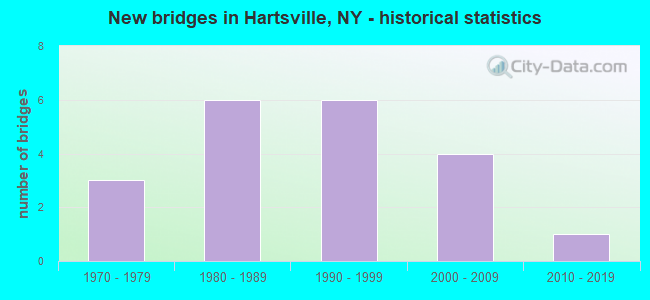
- New bridges - historical statistics
- 31970-1979
- 61980-1989
- 61990-1999
- 42000-2009
- 12010-2019

- Bridge Condition - Deck
- 23.5%Excellent
- 70.6%Very good
- 5.9%Good

- Bridge Condition - Superstructure
- 23.5%Excellent
- 58.8%Very good
- 5.9%Good
- 11.8%Satisfactory

- Bridge Condition - Substructure
- 5.9%Excellent
- 29.4%Very good
- 47.1%Good
- 5.9%Satisfactory
- 5.9%Fair
- 5.9%Poor

- Bridge Condition - Channel
- 5.0%Very good
- 15.0%Good
- 30.0%Satisfactory
- 45.0%Fair
- 5.0%Poor
Find on map >> Show street view
Structure Number: 221703, Location: 43 MI N GREENWOOD (Lat: 42.192378, Lng: -77.629317), Route carried "on" structure: Other road , Year Built: 2014, Status: Open, Structure Length: 1.37m (4.49ft), Average Daily Traffic: 43 (year 2018), Truck Traffic: 15%, Average Future Daily Traffic: 60 (year 2038), Design Load: HS 25 or greater, Features Intersected: SLATE CREEK, Facility Carried by Structure: SLATE CREEK ROAD
Minimum Vertical Clearance: 30+ m (98+ ft), Kilometerpoint: 0.225, Lanes on structure: 2, Owner: Town or Township Highway Agency, Maintenance Responsibility: County Highway Agency, Approaching Roadway Width: 5.8m (19.0ft), Skew: 4 degrees, Material/Design: Prestressed concrete, Design/Construction: Box Beam or Girders - Multiple, Number Of Spans In Main Unit: 1, Length of Maximum Span: 12.8m (42.0ft), Curb-To-Curb Width: 8.2m (26.9ft), Out-to-Out Width: 8.7m (28.5ft)
Condition: Deck: Very good, Superstructure: Very good, Substructure: Very good, Channel: Very good, Operating Rating: 72.6 metric tons, Method Used To Determine Operating Rating: Load Factor (LF), Inventory Rating: 43.5 metric tons, Method Used To Determine Inventory Rating: Load Factor (LF), Structural Evaluation: Equal to present desirable criteria, Deck Geometry: Equal to present minimum criteria, Waterway Adequacy: Equal to present desirable criteria, Approach Roadway Alignment: Equal to present minimum criteria, Length Of Structure Improvement: 1.37m (4.49ft), Designated Inspection Frequency: Every 24 months, Inspection Date: October 2020, Bridge Improvement Cost: $458,000, Roadway Improvement Cost: $268,000, Total Project Cost: $726,000 ( Estimate for 2021), Wearing Surface/Protective System: Wearing Surface: Bituminous, Membrane: Other
Find on map >> Show street view
Structure Number: 221704, Location: 4 MI. NW GREENWOOD (Lat: 42.193947, Lng: -77.683986), Route carried "on" structure: Other road , Year Built: 1986, Year Reconstructed: 2016, Status: Open, Structure Length: 0.88m (2.89ft), Average Daily Traffic: 43 (year 2018), Truck Traffic: 15%, Average Future Daily Traffic: 60 (year 2038), Design Load: HS 25 or greater, Features Intersected: TRIB SLATE CREEK, Facility Carried by Structure: SLATE CREEK ROAD
Minimum Vertical Clearance: 30+ m (98+ ft), Kilometerpoint: 4.795, Lanes on structure: 2, Owner: Town or Township Highway Agency, Maintenance Responsibility: County Highway Agency, Approaching Roadway Width: 5.5m (18.0ft), Material/Design: Concrete, Design/Construction: Box Beam or Girders - Multiple, Number Of Spans In Main Unit: 1, Length of Maximum Span: 8.2m (26.9ft), Curb-To-Curb Width: 7.3m (24.0ft), Out-to-Out Width: 7.4m (24.3ft)
Condition: Deck: Excellent, Superstructure: Excellent, Substructure: Good, Channel: Good, Operating Rating: 84.4 metric tons, Method Used To Determine Operating Rating: Load Factor (LF), Inventory Rating: 49.9 metric tons, Method Used To Determine Inventory Rating: Load Factor (LF), Structural Evaluation: Better than present minimum criteria, Deck Geometry: Equal to present minimum criteria, Waterway Adequacy: Better than present minimum criteria, Approach Roadway Alignment: Meets minimum limits, Length Of Structure Improvement: 0.88m (2.89ft), Designated Inspection Frequency: Every 24 months, Inspection Date: October 2020, Bridge Improvement Cost: $282,000, Roadway Improvement Cost: $165,000, Total Project Cost: $448,000 ( Estimate for 2021), Wearing Surface/Protective System: Wearing Surface: Bituminous, Membrane: Other
Find on map >> Show street view
Structure Number: 221705, Location: 5.0 MI. NW OF GREENWOOD (Lat: 42.193194, Lng: -77.687869), Route carried "on" structure: Other road , Year Built: 2008, Status: Open, Structure Length: 1.16m (3.81ft), Average Daily Traffic: 43 (year 2018), Truck Traffic: 15%, Average Future Daily Traffic: 60 (year 2038), Design Load: HS 25 or greater, Features Intersected: TRIB SLATE CREEK, Facility Carried by Structure: SLATE CREEK ROAD
Minimum Vertical Clearance: 30+ m (98+ ft), Kilometerpoint: 5.133, Lanes on structure: 2, Owner: Town or Township Highway Agency, Maintenance Responsibility: County Highway Agency, Approaching Roadway Width: 5.5m (18.0ft), Skew: 4 degrees, Material/Design: Prestressed concrete, Design/Construction: Box Beam or Girders - Multiple, Number Of Spans In Main Unit: 1, Length of Maximum Span: 10.7m (35.1ft), Curb-To-Curb Width: 8.2m (26.9ft), Out-to-Out Width: 8.7m (28.5ft)
Condition: Deck: Excellent, Superstructure: Excellent, Substructure: Good, Channel: Good, Inventory Rating: 69.9 metric tons, Method Used To Determine Inventory Rating: Load Factor (LF), Structural Evaluation: Better than present minimum criteria, Deck Geometry: Equal to present minimum criteria, Waterway Adequacy: Somewhat better than minimum adequacy, Approach Roadway Alignment: Better than present minimum criteria, Length Of Structure Improvement: 1.15m (3.77ft), Designated Inspection Frequency: Every 24 months, Inspection Date: September 2020, Bridge Improvement Cost: $481,000, Roadway Improvement Cost: $282,000, Total Project Cost: $763,000 ( Estimate for 2021), Wearing Surface/Protective System: Wearing Surface: Bituminous, Membrane: Other
Find on map >> Show street view
Structure Number: 221706, Location: 0.1 MI EAST OF CO ROAD 28 (Lat: 42.247142, Lng: -77.691764), Route carried "on" structure: Other road , Year Built: 1997, Status: Open, Structure Length: 1.98m (6.50ft), Average Daily Traffic: 39 (year 2018), Truck Traffic: 5%, Average Future Daily Traffic: 55 (year 2038), Design Load: HS 20, Features Intersected: PURDY CREEK, Facility Carried by Structure: PURDY-FALL CREEK R
Minimum Vertical Clearance: 30+ m (98+ ft), Kilometerpoint: 0.097, Lanes on structure: 2, Owner: Town or Township Highway Agency, Maintenance Responsibility: County Highway Agency, Approaching Roadway Width: 4.3m (14.1ft), Skew: 1 degrees, Material/Design: Prestressed concrete, Design/Construction: Box Beam or Girders - Multiple, Number Of Spans In Main Unit: 1, Length of Maximum Span: 19.2m (63.0ft), Curb-To-Curb Width: 8.0m (26.2ft), Out-to-Out Width: 8.5m (27.9ft)
Condition: Deck: Very good, Superstructure: Very good, Substructure: Very good, Channel: Fair, Operating Rating: 72.6 metric tons, Method Used To Determine Operating Rating: Load Factor (LF), Inventory Rating: 44.5 metric tons, Method Used To Determine Inventory Rating: Load Factor (LF), Structural Evaluation: Equal to present desirable criteria, Deck Geometry: Equal to present minimum criteria, Waterway Adequacy: Meets minimum limits, Approach Roadway Alignment: Equal to present minimum criteria, Length Of Structure Improvement: 1.98m (6.50ft), Designated Inspection Frequency: Every 24 months, Inspection Date: November 2021, Bridge Improvement Cost: $571,000, Roadway Improvement Cost: $334,000, Total Project Cost: $905,000 ( Estimate for 2021), Wearing Surface/Protective System: Wearing Surface: Bituminous, Membrane: Other
Find on map >> Show street view
Structure Number: 221708, Location: .2 MILE W OF HARTSVILLE (Lat: 42.247639, Lng: -77.697025), Route carried "on" structure: Other road , Year Built: 1987, Status: Posted for load-capacity, Structure Length: 1.68m (5.51ft), Average Daily Traffic: 107 (year 2020), Truck Traffic: 5%, Average Future Daily Traffic: 150 (year 2040), Features Intersected: WEBB HOLLOW CREEK, Facility Carried by Structure: JENKINS-HENRY RD
Minimum Vertical Clearance: 30+ m (98+ ft), Kilometerpoint: 0.274, Lanes on structure: 2, Owner: Town or Township Highway Agency, Maintenance Responsibility: County Highway Agency, Approaching Roadway Width: 5.5m (18.0ft), Skew: 3 degrees, Material/Design: Wood or Timber, Design/Construction: Stringer/Multi-beam, Number Of Spans In Main Unit: 1, Length of Maximum Span: 16.4m (53.8ft), Curb-To-Curb Width: 8.5m (27.9ft), Out-to-Out Width: 8.9m (29.2ft)
Condition: Deck: Very good, Superstructure: Very good, Substructure: Good, Channel: Fair, Operating Rating: 22.7 metric tons, Method Used To Determine Operating Rating: Load Factor (LF), Inventory Rating: 17.2 metric tons, Method Used To Determine Inventory Rating: Load Factor (LF), Structural Evaluation: Somewhat better than minimum adequacy, Deck Geometry: Equal to present minimum criteria, Waterway Adequacy: Meets minimum limits, Approach Roadway Alignment: Equal to present desirable criteria, Length Of Structure Improvement: 1.67m (5.48ft), Designated Inspection Frequency: Every 24 months, Inspection Date: December 2021, Bridge Improvement Cost: $1,089,000, Roadway Improvement Cost: $638,000, Total Project Cost: $1,727,000 ( Estimate for 2021), Deck Structure Type: Wood or Timber, Wearing Surface/Protective System: Wearing Surface: Other
Find on map >> Show street view
Structure Number: 221709, Location: 2.4 MILES W OF CANISTEO (Lat: 42.266317, Lng: -77.653803), Route carried "on" structure: Other road , Year Built: 1997, Status: Open, Structure Length: 1.04m (3.41ft), Average Daily Traffic: 61 (year 2016), Truck Traffic: 5%, Average Future Daily Traffic: 85 (year 2036), Design Load: HS 20, Features Intersected: ASHBAUGH CREEK, Facility Carried by Structure: HINKLEY HILL ROAD
Minimum Vertical Clearance: 30+ m (98+ ft), Kilometerpoint: 0.016, Lanes on structure: 2, Owner: Town or Township Highway Agency, Maintenance Responsibility: County Highway Agency, Approaching Roadway Width: 5.5m (18.0ft), Skew: 1 degrees, Material/Design: Steel, Design/Construction: Stringer/Multi-beam, Number Of Spans In Main Unit: 1, Length of Maximum Span: 9.7m (31.8ft), Curb-To-Curb Width: 8.5m (27.9ft), Out-to-Out Width: 8.8m (28.9ft)
Condition: Deck: Very good, Superstructure: Satisfactory, Substructure: Very good, Channel: Satisfactory, Operating Rating: 72.6 metric tons, Method Used To Determine Operating Rating: Load Factor (LF), Inventory Rating: 49.9 metric tons, Method Used To Determine Inventory Rating: Load Factor (LF), Structural Evaluation: Equal to present minimum criteria, Deck Geometry: Better than present minimum criteria, Waterway Adequacy: Better than present minimum criteria, Approach Roadway Alignment: Equal to present minimum criteria, Length Of Structure Improvement: 1.03m (3.38ft), Designated Inspection Frequency: Every 24 months, Inspection Date: March 2021, Bridge Improvement Cost: $411,000, Roadway Improvement Cost: $241,000, Total Project Cost: $651,000 ( Estimate for 2021), Deck Structure Type: Wood or Timber, Wearing Surface/Protective System: Wearing Surface: Bituminous, Membrane: Other
Find on map >> Show street view
Structure Number: 22171, Location: 3.7 MI W OF CANISTEO (Lat: 42.256047, Lng: -77.673811), Route carried "on" structure: Other road , Year Built: 2002, Status: Open, Structure Length: 2.07m (6.79ft), Average Daily Traffic: 62 (year 2016), Truck Traffic: 5%, Average Future Daily Traffic: 87 (year 2036), Design Load: HS 25 or greater, Features Intersected: PURDY CREEK, Facility Carried by Structure: BEARLICK HOLLW RD
Minimum Vertical Clearance: 30+ m (98+ ft), Kilometerpoint: 0.048, Lanes on structure: 2, Owner: Town or Township Highway Agency, Maintenance Responsibility: County Highway Agency, Approaching Roadway Width: 7.3m (24.0ft), Skew: 1 degrees, Material/Design: Prestressed concrete, Design/Construction: Box Beam or Girders - Multiple, Number Of Spans In Main Unit: 1, Length of Maximum Span: 20.1m (65.9ft), Curb-To-Curb Width: 8.2m (26.9ft), Out-to-Out Width: 8.6m (28.2ft)
Condition: Deck: Very good, Superstructure: Good, Substructure: Good, Channel: Satisfactory, Operating Rating: 76.2 metric tons, Method Used To Determine Operating Rating: Load Factor (LF), Inventory Rating: 45.4 metric tons, Method Used To Determine Inventory Rating: Load Factor (LF), Structural Evaluation: Better than present minimum criteria, Deck Geometry: Equal to present minimum criteria, Waterway Adequacy: Somewhat better than minimum adequacy, Approach Roadway Alignment: Better than present minimum criteria, Length Of Structure Improvement: 2.07m (6.79ft), Designated Inspection Frequency: Every 24 months, Inspection Date: October 2020, Bridge Improvement Cost: $627,000, Roadway Improvement Cost: $367,000, Total Project Cost: $994,000 ( Estimate for 2021), Wearing Surface/Protective System: Wearing Surface: Bituminous, Membrane: Other
Find on map >> Show street view
Structure Number: 221711, Location: 1.75 MI SW OF CANISTEO (Lat: 42.256856, Lng: -77.642678), Route carried "on" structure: Other road , Year Built: 2002, Status: Open, Structure Length: 2.04m (6.69ft), Average Daily Traffic: 14 (year 2017), Truck Traffic: 5%, Average Future Daily Traffic: 20 (year 2037), Design Load: HS 25 or greater, Features Intersected: PURDY CREEK, Facility Carried by Structure: JACK WHITE RD
Minimum Vertical Clearance: 30+ m (98+ ft), Kilometerpoint: 0.016, Lanes on structure: 2, Owner: Town or Township Highway Agency, Maintenance Responsibility: County Highway Agency, Approaching Roadway Width: 6.7m (22.0ft), Material/Design: Prestressed concrete, Design/Construction: Box Beam or Girders - Multiple, Number Of Spans In Main Unit: 1, Length of Maximum Span: 20.1m (65.9ft), Curb-To-Curb Width: 6.9m (22.6ft), Out-to-Out Width: 7.4m (24.3ft)
Condition: Deck: Good, Superstructure: Very good, Substructure: Excellent, Channel: Good, Operating Rating: 76.2 metric tons, Method Used To Determine Operating Rating: Load Factor (LF), Inventory Rating: 45.4 metric tons, Method Used To Determine Inventory Rating: Load Factor (LF), Structural Evaluation: Equal to present desirable criteria, Deck Geometry: Somewhat better than minimum adequacy, Waterway Adequacy: Equal to present minimum criteria, Approach Roadway Alignment: Equal to present minimum criteria, Length Of Structure Improvement: 2.04m (6.69ft), Designated Inspection Frequency: Every 24 months, Inspection Date: October 2020, Bridge Improvement Cost: $480,000, Roadway Improvement Cost: $281,000, Total Project Cost: $761,000 ( Estimate for 2021), Wearing Surface/Protective System: Wearing Surface: Bituminous, Membrane: Other
Find on map >> Show street view
Structure Number: 33334, Location: 1.2 MI SW OF CANISTEO (Lat: 42.257947, Lng: -77.625436), Route carried "on" structure: County highway , Year Built: 1986, Status: Open, Structure Length: 2.65m (8.69ft), Average Daily Traffic: 525 (year 2020), Truck Traffic: 12%, Average Future Daily Traffic: 735 (year 2040), Design Load: HS 20, Features Intersected: PURDY CREEK, Facility Carried by Structure: COUNTY ROAD 28
Minimum Vertical Clearance: 30+ m (98+ ft), Kilometerpoint: 15.334, Lanes on structure: 2, Owner: County Highway Agency, Approaching Roadway Width: 7.0m (23.0ft), Skew: 4 degrees, Material/Design: Prestressed concrete, Design/Construction: Box Beam or Girders - Multiple, Number Of Spans In Main Unit: 1, Length of Maximum Span: 25.9m (85.0ft), Curb-To-Curb Width: 8.6m (28.2ft), Out-to-Out Width: 9.4m (30.8ft)
Condition: Deck: Very good, Superstructure: Satisfactory, Substructure: Poor, Channel: Fair, Operating Rating: 98.0 metric tons, Method Used To Determine Operating Rating: Load Factor (LF), Inventory Rating: 52.6 metric tons, Method Used To Determine Inventory Rating: Load Factor (LF), Structural Evaluation: Meets minimum limits, Deck Geometry: Somewhat better than minimum adequacy, Waterway Adequacy: Meets minimum limits, Approach Roadway Alignment: Equal to present desirable criteria, Length Of Structure Improvement: 2.65m (8.69ft), Designated Inspection Frequency: Every 24 months, Inspection Date: December 2021, Bridge Improvement Cost: $1,031,000, Roadway Improvement Cost: $604,000, Total Project Cost: $1,635,000 ( Estimate for 2021), Deck Structure Type: Concrete Cast-file-Place, Wearing Surface/Protective System: Wearing Surface: Bituminous
Find on map >> Show street view
Structure Number: 333341, Location: 2.4 MILES W OF CANISTEO (Lat: 42.262225, Lng: -77.654867), Route carried "on" structure: County highway , Year Built: 1972, Status: Open, Structure Length: 0.82m (2.69ft), Average Daily Traffic: 525 (year 2020), Truck Traffic: 12%, Average Future Daily Traffic: 735 (year 2040), Features Intersected: TRIB PURDY CREEK, Facility Carried by Structure: COUNTY ROAD 28
Minimum Vertical Clearance: 30+ m (98+ ft), Kilometerpoint: 12.711, Lanes on structure: 2, Owner: County Highway Agency, Approaching Roadway Width: 5.5m (18.0ft), Material/Design: Steel, Design/Construction: Culvert, Number Of Spans In Main Unit: 2, Length of Maximum Span: 3.7m (12.1ft)
Condition: Channel: Fair, Culverts: Satisfactory, Operating Rating: 89.8 metric tons, Method Used To Determine Operating Rating: Load Factor (LF), Inventory Rating: 89.8 metric tons, Method Used To Determine Inventory Rating: Load Factor (LF), Structural Evaluation: Equal to present minimum criteria, Waterway Adequacy: Meets minimum limits, Approach Roadway Alignment: Equal to present desirable criteria, Length Of Structure Improvement: 0.82m (2.69ft), Designated Inspection Frequency: Every 24 months, Inspection Date: December 2021, Bridge Improvement Cost: $98,000, Roadway Improvement Cost: $57,000, Total Project Cost: $156,000 ( Estimate for 2021)
Find on map >> Show street view
Structure Number: 333342, Location: 4.1 MI W OF CANISTEO (Lat: 42.254958, Lng: -77.679483), Route carried "on" structure: County highway , Year Built: 1989, Status: Open, Structure Length: 0.73m (2.40ft), Average Daily Traffic: 391 (year 2020), Truck Traffic: 2%, Average Future Daily Traffic: 547 (year 2040), Features Intersected: TRIB PURDY CREEK, Facility Carried by Structure: COUNTY ROAD 28
Minimum Vertical Clearance: 30+ m (98+ ft), Kilometerpoint: 10.475, Lanes on structure: 2, Owner: County Highway Agency, Approaching Roadway Width: 5.5m (18.0ft), Material/Design: Wood or Timber, Design/Construction: Slab, Number Of Spans In Main Unit: 1, Length of Maximum Span: 6.7m (22.0ft), Curb-To-Curb Width: 9.2m (30.2ft), Out-to-Out Width: 9.8m (32.2ft)
Condition: Deck: Very good, Superstructure: Very good, Substructure: Good, Channel: Fair, Operating Rating: 54.4 metric tons, Method Used To Determine Operating Rating: Load Factor (LF), Inventory Rating: 39.0 metric tons, Method Used To Determine Inventory Rating: Load Factor (LF), Structural Evaluation: Better than present minimum criteria, Deck Geometry: Equal to present minimum criteria, Waterway Adequacy: Meets minimum limits, Approach Roadway Alignment: Equal to present desirable criteria, Length Of Structure Improvement: 0.73m (2.40ft), Designated Inspection Frequency: Every 24 months, Inspection Date: December 2021, Bridge Improvement Cost: $225,000, Roadway Improvement Cost: $132,000, Total Project Cost: $357,000 ( Estimate for 2021), Wearing Surface/Protective System: Wearing Surface: Bituminous
Find on map >> Show street view
Structure Number: 333343, Location: 4.9 MI SW OF CANISTEO (Lat: 42.247131, Lng: -77.693553), Route carried "on" structure: County highway , Year Built: 1973, Status: Open, Structure Length: 0.91m (2.99ft), Average Daily Traffic: 391 (year 2020), Truck Traffic: 2%, Average Future Daily Traffic: 547 (year 2040), Features Intersected: WEBB HOLLOW CREEK, Facility Carried by Structure: CO RD 28
Minimum Vertical Clearance: 30+ m (98+ ft), Kilometerpoint: 9.010, Lanes on structure: 2, Owner: County Highway Agency, Approaching Roadway Width: 5.8m (19.0ft), Skew: 1 degrees, Material/Design: Steel, Design/Construction: Culvert, Number Of Spans In Main Unit: 2, Length of Maximum Span: 3.9m (12.8ft)
Condition: Channel: Poor, Culverts: Satisfactory, Operating Rating: 89.8 metric tons, Method Used To Determine Operating Rating: Load Factor (LF), Inventory Rating: 89.8 metric tons, Method Used To Determine Inventory Rating: Load Factor (LF), Structural Evaluation: Equal to present minimum criteria, Waterway Adequacy: Meets minimum limits, Approach Roadway Alignment: Equal to present desirable criteria, Length Of Structure Improvement: 0.91m (2.99ft), Designated Inspection Frequency: Every 24 months, Inspection Date: November 2021, Bridge Improvement Cost: $115,000, Roadway Improvement Cost: $67,000, Total Project Cost: $182,000 ( Estimate for 2021)
Find on map >> Show street view
Structure Number: 333344, Location: 5.1 MI SW OF CANISTED (Lat: 42.245400, Lng: -77.695458), Route carried "on" structure: County highway , Year Built: 1986, Status: Open, Structure Length: 1.34m (4.40ft), Average Daily Traffic: 391 (year 2020), Truck Traffic: 2%, Average Future Daily Traffic: 547 (year 2040), Features Intersected: PURDY CREEK, Facility Carried by Structure: COUNTY ROAD 28
Minimum Vertical Clearance: 30+ m (98+ ft), Kilometerpoint: 8.769, Lanes on structure: 2, Owner: County Highway Agency, Approaching Roadway Width: 5.5m (18.0ft), Skew: 2 degrees, Material/Design: Prestressed concrete, Design/Construction: Box Beam or Girders - Multiple, Number Of Spans In Main Unit: 1, Length of Maximum Span: 12.8m (42.0ft), Curb-To-Curb Width: 8.5m (27.9ft), Out-to-Out Width: 8.6m (28.2ft)
Condition: Deck: Very good, Superstructure: Very good, Substructure: Very good, Channel: Satisfactory, Inventory Rating: 71.7 metric tons, Method Used To Determine Inventory Rating: Load Factor (LF), Structural Evaluation: Equal to present desirable criteria, Deck Geometry: Equal to present minimum criteria, Waterway Adequacy: Meets minimum limits, Approach Roadway Alignment: Equal to present desirable criteria, Length Of Structure Improvement: 1.34m (4.40ft), Designated Inspection Frequency: Every 24 months, Inspection Date: November 2021, Bridge Improvement Cost: $579,000, Roadway Improvement Cost: $339,000, Total Project Cost: $918,000 ( Estimate for 2021), Deck Structure Type: Concrete Cast-file-Place, Wearing Surface/Protective System: Wearing Surface: Bituminous, Deck Protection: Epoxy Coated Reinforcing
Find on map >> Show street view
Structure Number: 333345, Location: 5.3 MI SW OF CANISTEO (Lat: 42.241072, Lng: -77.699639), Route carried "on" structure: County highway , Year Built: 1992, Status: Open, Structure Length: 1.16m (3.81ft), Average Daily Traffic: 391 (year 2020), Truck Traffic: 2%, Average Future Daily Traffic: 547 (year 2040), Design Load: HS 20, Features Intersected: ACKER CREEK, Facility Carried by Structure: COUNTY ROAD 28
Minimum Vertical Clearance: 30+ m (98+ ft), Kilometerpoint: 8.174, Lanes on structure: 2, Owner: County Highway Agency, Approaching Roadway Width: 6.1m (20.0ft), Skew: 2 degrees, Material/Design: Prestressed concrete, Design/Construction: Box Beam or Girders - Multiple, Number Of Spans In Main Unit: 1, Length of Maximum Span: 10.9m (35.8ft), Curb-To-Curb Width: 9.4m (30.8ft), Out-to-Out Width: 9.8m (32.2ft)
Condition: Deck: Very good, Superstructure: Very good, Substructure: Good, Channel: Fair, Operating Rating: 62.6 metric tons, Method Used To Determine Operating Rating: Load Factor (LF), Inventory Rating: 39.0 metric tons, Method Used To Determine Inventory Rating: Load Factor (LF), Structural Evaluation: Better than present minimum criteria, Deck Geometry: Equal to present minimum criteria, Waterway Adequacy: Equal to present desirable criteria, Approach Roadway Alignment: Equal to present desirable criteria, Length Of Structure Improvement: 1.15m (3.77ft), Designated Inspection Frequency: Every 24 months, Inspection Date: May 2020, Bridge Improvement Cost: $508,000, Roadway Improvement Cost: $297,000, Total Project Cost: $805,000 ( Estimate for 2021), Wearing Surface/Protective System: Wearing Surface: Bituminous, Membrane: Other
Find on map >> Show street view
Structure Number: 333346, Location: 6.0 MI SW OF CANISTEO (Lat: 42.232381, Lng: -77.709603), Route carried "on" structure: County highway , Year Built: 1974, Status: Open, Structure Length: 1.22m (4.00ft), Average Daily Traffic: 391 (year 2020), Truck Traffic: 2%, Average Future Daily Traffic: 547 (year 2040), Features Intersected: PURDY CREEK, Facility Carried by Structure: COUNTY ROAD 28
Minimum Vertical Clearance: 30+ m (98+ ft), Kilometerpoint: 6.903, Lanes on structure: 2, Owner: County Highway Agency, Approaching Roadway Width: 5.8m (19.0ft), Skew: 1 degrees, Material/Design: Steel, Design/Construction: Culvert, Number Of Spans In Main Unit: 2, Length of Maximum Span: 3.6m (11.8ft)
Condition: Channel: Fair, Culverts: Satisfactory, Operating Rating: 89.8 metric tons, Method Used To Determine Operating Rating: Load Factor (LF), Inventory Rating: 89.8 metric tons, Method Used To Determine Inventory Rating: Load Factor (LF), Structural Evaluation: Equal to present minimum criteria, Waterway Adequacy: Meets minimum limits, Approach Roadway Alignment: Somewhat better than minimum adequacy, Length Of Structure Improvement: 1.21m (3.97ft), Designated Inspection Frequency: Every 24 months, Inspection Date: December 2021, Bridge Improvement Cost: $153,000, Roadway Improvement Cost: $90,000, Total Project Cost: $243,000 ( Estimate for 2021)
Find on map >> Show street view
Structure Number: 333347, Location: 6.4 MILES SW OF CANISTEO (Lat: 42.228536, Lng: -77.714147), Route carried "on" structure: County highway , Year Built: 1993, Status: Posted for load-capacity, Structure Length: 0.79m (2.59ft), Average Daily Traffic: 391 (year 2020), Truck Traffic: 2%, Average Future Daily Traffic: 547 (year 2040), Design Load: HS 20, Features Intersected: TRIB PURDY CREEK, Facility Carried by Structure: COUNTY ROAD 28
Minimum Vertical Clearance: 30+ m (98+ ft), Kilometerpoint: 6.323, Lanes on structure: 2, Owner: County Highway Agency, Approaching Roadway Width: 5.8m (19.0ft), Skew: 3 degrees, Material/Design: Wood or Timber, Design/Construction: Slab, Number Of Spans In Main Unit: 1, Length of Maximum Span: 7.3m (24.0ft), Curb-To-Curb Width: 8.9m (29.2ft), Out-to-Out Width: 9.8m (32.2ft)
Condition: Deck: Very good, Superstructure: Very good, Substructure: Good, Channel: Fair, Operating Rating: 40.8 metric tons, Method Used To Determine Operating Rating: Load Factor (LF), Inventory Rating: 28.1 metric tons, Method Used To Determine Inventory Rating: Load Factor (LF), Structural Evaluation: Better than present minimum criteria, Deck Geometry: Equal to present minimum criteria, Waterway Adequacy: Meets minimum limits, Approach Roadway Alignment: Equal to present desirable criteria, Length Of Structure Improvement: 0.79m (2.59ft), Designated Inspection Frequency: Every 24 months, Inspection Date: December 2021, Bridge Improvement Cost: $404,000, Roadway Improvement Cost: $237,000, Total Project Cost: $640,000 ( Estimate for 2021), Wearing Surface/Protective System: Wearing Surface: Bituminous
Find on map >> Show street view
Structure Number: 333348, Location: 6.6 MILES SW OF CANISTEO (Lat: 42.224428, Lng: -77.718583), Route carried "on" structure: County highway , Year Built: 1989, Status: Posted for load-capacity, Structure Length: 0.98m (3.22ft), Average Daily Traffic: 391 (year 2020), Truck Traffic: 2%, Average Future Daily Traffic: 547 (year 2040), Features Intersected: PURDY CREEK, Facility Carried by Structure: COUNTY ROAD 28
Minimum Vertical Clearance: 30+ m (98+ ft), Kilometerpoint: 5.728, Lanes on structure: 2, Owner: County Highway Agency, Approaching Roadway Width: 5.5m (18.0ft), Material/Design: Wood or Timber, Design/Construction: Slab, Number Of Spans In Main Unit: 1, Length of Maximum Span: 9.4m (30.8ft), Curb-To-Curb Width: 9.0m (29.5ft), Out-to-Out Width: 9.8m (32.2ft)
Condition: Deck: Very good, Superstructure: Very good, Substructure: Fair, Channel: Satisfactory, Operating Rating: 46.3 metric tons, Method Used To Determine Operating Rating: Load Factor (LF), Inventory Rating: 31.8 metric tons, Method Used To Determine Inventory Rating: Load Factor (LF), Structural Evaluation: Somewhat better than minimum adequacy, Deck Geometry: Equal to present minimum criteria, Waterway Adequacy: Meets minimum limits, Approach Roadway Alignment: Equal to present desirable criteria, Length Of Structure Improvement: 0.97m (3.18ft), Designated Inspection Frequency: Every 24 months, Inspection Date: November 2021, Bridge Improvement Cost: $403,000, Roadway Improvement Cost: $236,000, Total Project Cost: $639,000 ( Estimate for 2021), Wearing Surface/Protective System: Wearing Surface: Bituminous
Find on map >> Show street view
Structure Number: 333349, Location: 6.7 M SW OF CANISTEO (Lat: 42.223378, Lng: -77.719103), Route carried "on" structure: County highway , Year Built: 1999, Status: Open, Structure Length: 0.91m (2.99ft), Average Daily Traffic: 391 (year 2020), Truck Traffic: 2%, Average Future Daily Traffic: 547 (year 2040), Design Load: HS 25 or greater, Features Intersected: PURDY CREEK, Facility Carried by Structure: COUNTY ROAD 28
Minimum Vertical Clearance: 30+ m (98+ ft), Kilometerpoint: 5.615, Lanes on structure: 2, Owner: County Highway Agency, Approaching Roadway Width: 6.7m (22.0ft), Material/Design: Prestressed concrete, Design/Construction: Box Beam or Girders - Multiple, Number Of Spans In Main Unit: 1, Length of Maximum Span: 8.5m (27.9ft), Curb-To-Curb Width: 9.4m (30.8ft), Out-to-Out Width: 9.8m (32.2ft)
Condition: Deck: Excellent, Superstructure: Excellent, Substructure: Very good, Channel: Satisfactory, Operating Rating: 89.8 metric tons, Method Used To Determine Operating Rating: Load Factor (LF), Inventory Rating: 51.7 metric tons, Method Used To Determine Inventory Rating: Load Factor (LF), Structural Evaluation: Equal to present desirable criteria, Deck Geometry: Equal to present minimum criteria, Waterway Adequacy: Somewhat better than minimum adequacy, Approach Roadway Alignment: Equal to present desirable criteria, Length Of Structure Improvement: 0.91m (2.99ft), Designated Inspection Frequency: Every 24 months, Inspection Date: November 2021, Bridge Improvement Cost: $358,000, Roadway Improvement Cost: $209,000, Total Project Cost: $567,000 ( Estimate for 2021), Wearing Surface/Protective System: Wearing Surface: Bituminous, Membrane: Other
Find on map >> Show street view
Structure Number: 33335, Location: 6.8 MI SW OF CONISTEO (Lat: 42.221792, Lng: -77.719633), Route carried "on" structure: County highway , Year Built: 2008, Status: Open, Structure Length: 1.10m (3.61ft), Average Daily Traffic: 391 (year 2020), Truck Traffic: 2%, Average Future Daily Traffic: 547 (year 2040), Design Load: HS 25 or greater, Features Intersected: PURDY CREEK, Facility Carried by Structure: COUNTY ROAD 28
Minimum Vertical Clearance: 30+ m (98+ ft), Kilometerpoint: 5.422, Lanes on structure: 2, Owner: County Highway Agency, Approaching Roadway Width: 6.1m (20.0ft), Skew: 1 degrees, Material/Design: Prestressed concrete, Design/Construction: Box Beam or Girders - Multiple, Number Of Spans In Main Unit: 1, Length of Maximum Span: 10.4m (34.1ft), Curb-To-Curb Width: 9.4m (30.8ft), Out-to-Out Width: 9.9m (32.5ft)
Condition: Deck: Excellent, Superstructure: Excellent, Substructure: Good, Channel: Satisfactory, Operating Rating: 61.7 metric tons, Method Used To Determine Operating Rating: Load and Resistance Factor (LRFR), Inventory Rating: 40.8 metric tons, Method Used To Determine Inventory Rating: Load and Resistance Factor (LRFR), Structural Evaluation: Better than present minimum criteria, Deck Geometry: Equal to present minimum criteria, Waterway Adequacy: Somewhat better than minimum adequacy, Approach Roadway Alignment: Better than present minimum criteria, Length Of Structure Improvement: 1.09m (3.58ft), Designated Inspection Frequency: Every 24 months, Inspection Date: September 2020, Bridge Improvement Cost: $411,000, Roadway Improvement Cost: $241,000, Total Project Cost: $651,000 ( Estimate for 2021), Wearing Surface/Protective System: Wearing Surface: Bituminous, Membrane: Other
Find on map >> Show street view
Structure Number: 333391, Location: 4.1 MI SW OF HORNELL (Lat: 42.280633, Lng: -77.720897), Route carried "on" structure: County highway , Year Built: 1991, Status: Open, Structure Length: 0.91m (2.99ft), Average Daily Traffic: 467 (year 2018), Truck Traffic: 5%, Average Future Daily Traffic: 487 (year 2040), Features Intersected: CROSBY CREEK, Facility Carried by Structure: COUNTY ROAD 68
Minimum Vertical Clearance: 30+ m (98+ ft), Kilometerpoint: 2.365, Lanes on structure: 2, Owner: County Highway Agency, Approaching Roadway Width: 6.4m (21.0ft), Material/Design: Wood or Timber, Design/Construction: Slab, Number Of Spans In Main Unit: 1, Length of Maximum Span: 8.8m (28.9ft), Curb-To-Curb Width: 8.6m (28.2ft), Out-to-Out Width: 9.2m (30.2ft)
Condition: Deck: Very good, Superstructure: Very good, Substructure: Satisfactory, Channel: Fair, Operating Rating: 53.5 metric tons, Method Used To Determine Operating Rating: Load Factor (LF), Inventory Rating: 37.2 metric tons, Method Used To Determine Inventory Rating: Load Factor (LF), Structural Evaluation: Equal to present minimum criteria, Deck Geometry: Somewhat better than minimum adequacy, Waterway Adequacy: Meets minimum limits, Approach Roadway Alignment: Equal to present desirable criteria, Length Of Structure Improvement: 0.91m (2.99ft), Designated Inspection Frequency: Every 24 months, Inspection Date: December 2021, Bridge Improvement Cost: $345,000, Roadway Improvement Cost: $202,000, Total Project Cost: $548,000 ( Estimate for 2021), Wearing Surface/Protective System: Wearing Surface: Bituminous, Membrane: Other