Bridge Statistics for Hamptonburgh, New York (NY)
Condition, Traffic, Stress, Structural Evaluation, Project Costs
- National Bridge Inventory (NBI) Statistics
- 15Number of bridges
- 151ft / 45.6mTotal length
- $36,817,000Total costs
- 54,524Total average daily traffic
- 1,712Total average daily truck traffic
- National Bridge Inventory (NBI) Registered Bridges for Hamptonburgh
- No street view available for this location
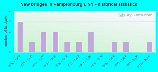
- New bridges - historical statistics
- 31900-1909
- 11910-1919
- 21920-1929
- 21930-1939
- 11940-1949
- 11950-1959
- 21960-1969
- 11980-1989
- 11990-1999
- 12010-2019

- Reconstructed bridges - Historical Statistics
- 11970-1979
- 31980-1989
- 11990-1999
- 12000-2009
- 12010-2019


- Bridge Condition - Deck
- 16.7%Very good
- 16.7%Good
- 33.3%Satisfactory
- 25.0%Fair
- 8.3%Poor

- Bridge Condition - Superstructure
- 16.7%Excellent
- 16.7%Very good
- 33.3%Good
- 8.3%Satisfactory
- 16.7%Fair
- 8.3%Poor

- Bridge Condition - Substructure
- 8.3%Excellent
- 16.7%Good
- 25.0%Satisfactory
- 41.7%Fair
- 8.3%Poor

- Bridge Condition - Channel
- 12.5%Very good
- 62.5%Good
- 25.0%Satisfactory
Find on map >> Show street view
Structure Number: 104048, Location: 1 MI E JCT SH207 & SH416 (Lat: 41.453353, Lng: -74.256217), Route carried "on" structure: State highway 207, Year Built: 1926, Year Reconstructed: 1989, Status: Open, Structure Length: 2.16m (7.09ft), Average Daily Traffic: 2,888 (year 2016), Truck Traffic: 4%, Average Future Daily Traffic: 3,573 (year 2040), Design Load: HS 20+Mod, Features Intersected: OTTERKILL CREEK
Minimum Vertical Clearance: 30+ m (98+ ft), Kilometerpoint: 10.603, Lanes on structure: 2, Base Highway Network: Yes, Owner: State Highway Agency, Approaching Roadway Width: 10.7m (35.1ft), Skew: 3 degrees, Material/Design: Steel, Design/Construction: Stringer/Multi-beam, Number Of Spans In Main Unit: 1, Length of Maximum Span: 20.1m (65.9ft), Curb-To-Curb Width: 10.5m (34.4ft), Out-to-Out Width: 11.0m (36.1ft)
Condition: Deck: Good, Superstructure: Very good, Substructure: Satisfactory, Channel: Good, Operating Rating: 59.0 metric tons, Method Used To Determine Operating Rating: Load and Resistance Factor Rating (LRFR) rating reported by rating factor(RF) method using HL-93 loadings, Inventory Rating: 45.4 metric tons, Method Used To Determine Inventory Rating: Load and Resistance Factor Rating (LRFR) rating reported by rating factor(RF) method using HL-93 loadings, Structural Evaluation: Equal to present minimum criteria, Deck Geometry: Somewhat better than minimum adequacy, Waterway Adequacy: Somewhat better than minimum adequacy, Approach Roadway Alignment: Equal to present desirable criteria, Length Of Structure Improvement: 2.16m (7.09ft), Designated Inspection Frequency: Every 24 months, Inspection Date: October 2021, Bridge Improvement Cost: $1,656,000, Roadway Improvement Cost: $970,000, Total Project Cost: $2,626,000 ( Estimate for 2021), Deck Structure Type: Concrete Cast-file-Place, Wearing Surface/Protective System: Wearing Surface: Integral Concrete, Deck Protection: Epoxy Coated Reinforcing
Find on map >> Show street view
Structure Number: 104049, Location: 3.7 MI E JCT RTS 207&416 (Lat: 41.456536, Lng: -74.209017), Route carried "on" structure: State highway 207, Year Built: 1927, Year Reconstructed: 1989, Status: Open, Structure Length: 1.98m (6.50ft), Average Daily Traffic: 5,139 (year 2018), Truck Traffic: 6%, Average Future Daily Traffic: 5,163 (year 2040), Design Load: HS 20+Mod, Features Intersected: OTTERKILL
Minimum Vertical Clearance: 30+ m (98+ ft), Kilometerpoint: 14.738, Lanes on structure: 2, Base Highway Network: Yes, Owner: State Highway Agency, Approaching Roadway Width: 11.6m (38.1ft), Material/Design: Steel, Design/Construction: Stringer/Multi-beam, Number Of Spans In Main Unit: 1, Length of Maximum Span: 18.2m (59.7ft), Curb-To-Curb Width: 11.6m (38.1ft), Out-to-Out Width: 12.2m (40.0ft)
Condition: Deck: Satisfactory, Superstructure: Good, Substructure: Fair, Channel: Satisfactory, Inventory Rating: 66.2 metric tons, Method Used To Determine Inventory Rating: Load Factor (LF), Structural Evaluation: Somewhat better than minimum adequacy, Deck Geometry: Somewhat better than minimum adequacy, Waterway Adequacy: Somewhat better than minimum adequacy, Approach Roadway Alignment: Equal to present desirable criteria, Length Of Structure Improvement: 1.98m (6.50ft), Designated Inspection Frequency: Every 24 months, Inspection Date: August 2021, Bridge Improvement Cost: $1,543,000, Roadway Improvement Cost: $904,000, Total Project Cost: $2,447,000 ( Estimate for 2021), Deck Structure Type: Concrete Cast-file-Place, Wearing Surface/Protective System: Wearing Surface: Other, Deck Protection: Epoxy Coated Reinforcing
Find on map >> Show street view
Structure Number: 104056, Location: 1.8 MI W JCT RTS 208+94 (Lat: 41.432694, Lng: -74.198847), Route carried "on" structure: State highway 208, Year Built: 1946, Year Reconstructed: 2012, Status: Open, Structure Length: 2.90m (9.51ft), Average Daily Traffic: 4,773 (year 2018), Truck Traffic: 5%, Average Future Daily Traffic: 4,795 (year 2040), Design Load: H 20, Features Intersected: OTTER KILL
Minimum Vertical Clearance: 30+ m (98+ ft), Kilometerpoint: 14.755, Lanes on structure: 2, Base Highway Network: Yes, Owner: State Highway Agency, Approaching Roadway Width: 8.8m (28.9ft), Skew: 4 degrees, Material/Design: Steel, Design/Construction: Stringer/Multi-beam, Number Of Spans In Main Unit: 1, Length of Maximum Span: 28.0m (91.9ft), Curb-To-Curb Width: 9.8m (32.2ft), Out-to-Out Width: 10.8m (35.4ft)
Condition: Deck: Good, Superstructure: Very good, Substructure: Satisfactory, Channel: Good, Operating Rating: 83.5 metric tons, Method Used To Determine Operating Rating: Load Factor (LF), Inventory Rating: 49.9 metric tons, Method Used To Determine Inventory Rating: Load Factor (LF), Structural Evaluation: Equal to present minimum criteria, Deck Geometry: Meets minimum limits, Waterway Adequacy: Somewhat better than minimum adequacy, Approach Roadway Alignment: Equal to present desirable criteria, Length Of Structure Improvement: 2.89m (9.48ft), Designated Inspection Frequency: Every 24 months, Inspection Date: September 2021, Bridge Improvement Cost: $1,961,000, Roadway Improvement Cost: $1,148,000, Total Project Cost: $3,109,000 ( Estimate for 2021), Deck Structure Type: Concrete Cast-file-Place, Wearing Surface/Protective System: Wearing Surface: Integral Concrete, Deck Protection: Epoxy Coated Reinforcing
Find on map >> Show street view
Structure Number: 104059, Location: 1.8 MI N JCT SH207 &SH208 (Lat: 41.476614, Lng: -74.217853), Route carried "on" structure: State highway 208, Year Built: 1938, Year Reconstructed: 1978, Status: Closed, Structure Length: 3.57m (11.71ft), Average Daily Traffic: 2,618 (year 2018), Truck Traffic: 6%, Average Future Daily Traffic: 2,630 (year 2040), Design Load: HS 20, Features Intersected: EX-NORFOLK SO RR
Minimum Vertical Clearance: 30+ m (98+ ft), Kilometerpoint: 20.917, Lanes on structure: 2, Base Highway Network: Yes, Owner: State Highway Agency, Approaching Roadway Width: 10.4m (34.1ft), Skew: 1 degrees, Material/Design: Steel, Design/Construction: Stringer/Multi-beam, Number Of Spans In Main Unit: 3, Length of Maximum Span: 13.7m (44.9ft), Curb-To-Curb Width: 10.3m (33.8ft), Out-to-Out Width: 11.2m (36.7ft)
Condition: Deck: Fair, Superstructure: Fair, Substructure: Poor, Deck Geometry: Meets minimum limits, Approach Roadway Alignment: Meets minimum limits, Bridge Posting: Required (Relationship of Operating Rating to Maximum Legal Load: > 39.9% below), Length Of Structure Improvement: 3.56m (11.68ft), Designated Inspection Frequency: Every 24 months, Inspection Date: June 2021, Bridge Improvement Cost: $2,018,000, Roadway Improvement Cost: $1,182,000, Total Project Cost: $3,200,000 ( Estimate for 2021), Deck Structure Type: Concrete Cast-file-Place, Wearing Surface/Protective System: Wearing Surface: Integral Concrete, Deck Protection: Epoxy Coated Reinforcing
Find on map >> Show street view
Structure Number: 10406, Location: 2 MI N JCT SH208 & SH207 (Lat: 41.479531, Lng: -74.221181), Route carried "on" structure: State highway 208, Year Built: 1938, Year Reconstructed: 1991, Status: Open, Structure Length: 3.23m (10.60ft), Average Daily Traffic: 5,348 (year 2020), Truck Traffic: 5%, Average Future Daily Traffic: 5,373 (year 2040), Design Load: HS 20, Features Intersected: NORFOLK SOUTHERN
Minimum Vertical Clearance: 30+ m (98+ ft), Kilometerpoint: 21.368, Lanes on structure: 2, Base Highway Network: Yes, Owner: State Highway Agency, Approaching Roadway Width: 12.2m (40.0ft), Material/Design: Steel, Design/Construction: Girder and Floorbeam System, Number Of Spans In Main Unit: 1, Length of Maximum Span: 30.4m (99.7ft), Curb-To-Curb Width: 11.9m (39.0ft), Out-to-Out Width: 13.5m (44.3ft)
Condition: Deck: Satisfactory, Superstructure: Fair, Substructure: Satisfactory, Inventory Rating: 59.9 metric tons, Method Used To Determine Inventory Rating: Load Factor (LF), Structural Evaluation: Somewhat better than minimum adequacy, Deck Geometry: Somewhat better than minimum adequacy, Underclear: Meets minimum limits, Approach Roadway Alignment: Equal to present desirable criteria, Length Of Structure Improvement: 3.23m (10.60ft), Designated Inspection Frequency: Every 24 months, Critical Feature Inspection Frequency: Every 24 months, Inspection Date: October 2021, Critical Feature Inspection Date: October 2021, Bridge Improvement Cost: $2,949,000, Roadway Improvement Cost: $1,727,000, Total Project Cost: $4,676,000 ( Estimate for 2021), Deck Structure Type: Concrete Cast-file-Place, Wearing Surface/Protective System: Wearing Surface: Integral Concrete, Deck Protection: Epoxy Coated Reinforcing
Find on map >> Show street view
Structure Number: 222321, Location: 3 MILES SW OF BURNSIDE (Lat: 41.419431, Lng: -74.242428), Route carried "on" structure: Other road , Year Built: 1907, Year Reconstructed: 2003, Status: Posted for load, Structure Length: 2.50m (8.20ft), Truck Traffic: 10%, Design Load: HS 20, Features Intersected: Middletown & NJ Railroad, Facility Carried by Structure: RIDGE ROAD
Minimum Vertical Clearance: 30+ m (98+ ft), Kilometerpoint: 2.253, Lanes on structure: 1, Owner: Town or Township Highway Agency, Approaching Roadway Width: 4.6m (15.1ft), Skew: 1 degrees, Material/Design: Steel, Design/Construction: Truss - Thru, Number Of Spans In Main Unit: 1, Length of Maximum Span: 24.6m (80.7ft), Curb-To-Curb Width: 4.0m (13.1ft), Out-to-Out Width: 4.6m (15.1ft)
Condition: Deck: Fair, Superstructure: Poor, Substructure: Fair, Operating Rating: 14.3 metric tons, Method Used To Determine Operating Rating: Load and Resistance Factor Rating (LRFR) rating reported by rating factor(RF) method using HL-93 loadings, Inventory Rating: 11.0 metric tons, Method Used To Determine Inventory Rating: Load and Resistance Factor Rating (LRFR) rating reported by rating factor(RF) method using HL-93 loadings, Structural Evaluation: Meets minimum limits, Deck Geometry: Somewhat better than minimum adequacy, Underclear: High priority of corrective action, Approach Roadway Alignment: Equal to present desirable criteria, Bridge Posting: Required (Relationship of Operating Rating to Maximum Legal Load: > 39.9% below), Length Of Structure Improvement: 2.49m (8.17ft), Designated Inspection Frequency: Every 12 months, Critical Feature Inspection Frequency: Every 12 months, Inspection Date: November 2021, Critical Feature Inspection Date: November 2021, Bridge Improvement Cost: $947,000, Roadway Improvement Cost: $555,000, Total Project Cost: $1,502,000 ( Estimate for 2021), Deck Structure Type: Corrugated Steel, Wearing Surface/Protective System: Wearing Surface: Bituminous
Find on map >> Show street view
Structure Number: 222322, Location: 1.3 MI E JCT SH416 &SH207 (Lat: 41.449525, Lng: -74.254925), Route carried "on" structure: Other road , Year Built: 1990, Status: Open, Structure Length: 4.33m (14.21ft), Truck Traffic: 4%, Design Load: HS 20, Features Intersected: MNRR PJ LINE, Facility Carried by Structure: HAMPTONBURGH ROAD
Minimum Vertical Clearance: 30+ m (98+ ft), Kilometerpoint: 1.657, Lanes on structure: 2, Owner: County Highway Agency, Approaching Roadway Width: 7.9m (25.9ft), Material/Design: Prestressed concrete continuous, Design/Construction: Box Beam or Girders - Multiple, Number Of Spans In Main Unit: 3, Length of Maximum Span: 20.1m (65.9ft), Curb-To-Curb Width: 7.7m (25.3ft), Out-to-Out Width: 8.8m (28.9ft)
Condition: Deck: Poor, Superstructure: Good, Substructure: Good, Operating Rating: 88.0 metric tons, Method Used To Determine Operating Rating: Load Factor (LF), Inventory Rating: 44.5 metric tons, Method Used To Determine Inventory Rating: Load Factor (LF), Structural Evaluation: Better than present minimum criteria, Deck Geometry: Equal to present minimum criteria, Underclear: Equal to present minimum criteria, Approach Roadway Alignment: Equal to present desirable criteria, Length Of Structure Improvement: 4.32m (14.17ft), Designated Inspection Frequency: Every 24 months, Inspection Date: August 2020, Bridge Improvement Cost: $1,031,000, Roadway Improvement Cost: $604,000, Total Project Cost: $1,635,000 ( Estimate for 2021), Wearing Surface/Protective System: Wearing Surface: Monolithic Concrete
Find on map >> Show street view
Structure Number: 334467, Location: 2.9 MI NE OF GOSHEN (Lat: 41.425244, Lng: -74.282769), Route carried "on" structure: Other road , Year Built: 1983, Status: Open, Structure Length: 1.86m (6.10ft), Average Daily Traffic: 2,181 (year 2020), Truck Traffic: 6%, Average Future Daily Traffic: 2,698 (year 2040), Features Intersected: OTTER KILL, Facility Carried by Structure: SARAH WELLS TRAIL
Minimum Vertical Clearance: 30+ m (98+ ft), Kilometerpoint: 3.105, Lanes on structure: 2, Owner: County Highway Agency, Approaching Roadway Width: 7.6m (24.9ft), Material/Design: Steel, Design/Construction: Stringer/Multi-beam, Number Of Spans In Main Unit: 1, Length of Maximum Span: 17.3m (56.8ft), Curb-To-Curb Width: 11.4m (37.4ft), Out-to-Out Width: 12.4m (40.7ft)
Condition: Deck: Satisfactory, Superstructure: Good, Substructure: Fair, Channel: Good, Operating Rating: 87.5 metric tons, Method Used To Determine Operating Rating: Load and Resistance Factor Rating (LRFR) rating reported by rating factor(RF) method using HL-93 loadings, Inventory Rating: 67.4 metric tons, Method Used To Determine Inventory Rating: Load and Resistance Factor Rating (LRFR) rating reported by rating factor(RF) method using HL-93 loadings, Structural Evaluation: Somewhat better than minimum adequacy, Deck Geometry: Somewhat better than minimum adequacy, Waterway Adequacy: Somewhat better than minimum adequacy, Approach Roadway Alignment: Equal to present desirable criteria, Length Of Structure Improvement: 1.85m (6.07ft), Designated Inspection Frequency: Every 24 months, Inspection Date: September 2021, Bridge Improvement Cost: $1,939,000, Roadway Improvement Cost: $1,135,000, Total Project Cost: $3,074,000 ( Estimate for 2021), Deck Structure Type: Concrete Cast-file-Place, Wearing Surface/Protective System: Wearing Surface: Bituminous
Find on map >> Show street view
Structure Number: 334468, Location: 3.1 MI N OF GOSHEN (Lat: 41.449589, Lng: -74.332417), Route carried "on" structure: County highway , Year Built: 2016, Status: Open, Structure Length: 10.12m (33.20ft), Average Daily Traffic: 5,974 (year 2020), Truck Traffic: 4%, Average Future Daily Traffic: 7,391 (year 2040), Design Load: HL 93, Features Intersected: WALLKILL RIVER, Facility Carried by Structure: SCOTCHTOWN AVENUE
Minimum Vertical Clearance: 30+ m (98+ ft), Kilometerpoint: 5.358, Lanes on structure: 2, Owner: County Highway Agency, Approaching Roadway Width: 9.8m (32.2ft), Material/Design: Steel continuous, Design/Construction: Stringer/Multi-beam, Number Of Spans In Main Unit: 2, Length of Maximum Span: 52.7m (172.9ft), Curb-To-Curb Width: 9.8m (32.2ft), Out-to-Out Width: 11.0m (36.1ft)
Condition: Deck: Very good, Superstructure: Excellent, Substructure: Excellent, Channel: Very good, Operating Rating: 94.3 metric tons, Method Used To Determine Operating Rating: Load Factor (LF), Inventory Rating: 56.2 metric tons, Method Used To Determine Inventory Rating: Load Factor (LF), Structural Evaluation: Superior to present desirable criteria, Deck Geometry: Meets minimum limits, Waterway Adequacy: Superior to present desirable criteria, Approach Roadway Alignment: Better than present minimum criteria, Length Of Structure Improvement: 10.11m (33.17ft), Designated Inspection Frequency: Every 24 months, Inspection Date: August 2020, Bridge Improvement Cost: $4,868,000, Roadway Improvement Cost: $2,850,000, Total Project Cost: $7,718,000 ( Estimate for 2021), Deck Structure Type: Concrete Cast-file-Place, Wearing Surface/Protective System: Wearing Surface: Integral Concrete, Deck Protection: Epoxy Coated Reinforcing
Find on map >> Show street view
Structure Number: 334469, Location: 1.9 MI W CAMPBELL HALL (Lat: 41.457292, Lng: -74.300294), Route carried "on" structure: County highway , Year Built: 1962, Year Reconstructed: 2017, Status: Open, Structure Length: 8.53m (27.99ft), Average Daily Traffic: 3,182 (year 2018), Truck Traffic: 5%, Average Future Daily Traffic: 3,937 (year 2040), Design Load: HS 20, Features Intersected: WALLKILL RIVER, Facility Carried by Structure: STONY FORD ROAD
Minimum Vertical Clearance: 30+ m (98+ ft), Kilometerpoint: 1.545, Lanes on structure: 2, Owner: County Highway Agency, Approaching Roadway Width: 9.1m (29.9ft), Material/Design: Prestressed concrete, Design/Construction: Box Beam or Girders - Multiple, Number Of Spans In Main Unit: 3, Length of Maximum Span: 27.7m (90.9ft), Curb-To-Curb Width: 9.0m (29.5ft), Out-to-Out Width: 10.0m (32.8ft)
Condition: Deck: Very good, Superstructure: Excellent, Substructure: Good, Channel: Good, Operating Rating: 66.7 metric tons, Method Used To Determine Operating Rating: Load and Resistance Factor Rating (LRFR) rating reported by rating factor(RF) method using HL-93 loadings, Inventory Rating: 48.9 metric tons, Method Used To Determine Inventory Rating: Load and Resistance Factor Rating (LRFR) rating reported by rating factor(RF) method using HL-93 loadings, Structural Evaluation: Better than present minimum criteria, Deck Geometry: Meets minimum limits, Waterway Adequacy: Somewhat better than minimum adequacy, Approach Roadway Alignment: Equal to present desirable criteria, Length Of Structure Improvement: 8.53m (27.99ft), Designated Inspection Frequency: Every 24 months, Inspection Date: September 2021, Bridge Improvement Cost: $2,049,000, Roadway Improvement Cost: $1,200,000, Total Project Cost: $3,248,000 ( Estimate for 2021), Wearing Surface/Protective System: Wearing Surface: Bituminous, Membrane: Preformed Fabric
Find on map >> Show street view
Structure Number: 33447, Location: 0.7 MI SW CAMPBELL HALL (Lat: 41.447961, Lng: -74.271869), Route carried "on" structure: County highway , Year Built: 1962, Status: Open, Structure Length: 2.96m (9.71ft), Average Daily Traffic: 1,591 (year 2015), Truck Traffic: 5%, Average Future Daily Traffic: 1,968 (year 2040), Design Load: HS 20, Features Intersected: OTTER KILL, Facility Carried by Structure: EGBERTSON ROAD
Minimum Vertical Clearance: 30+ m (98+ ft), Kilometerpoint: 2.301, Lanes on structure: 2, Owner: County Highway Agency, Approaching Roadway Width: 7.6m (24.9ft), Material/Design: Steel, Design/Construction: Stringer/Multi-beam, Number Of Spans In Main Unit: 1, Length of Maximum Span: 28.0m (91.9ft), Curb-To-Curb Width: 8.2m (26.9ft), Out-to-Out Width: 9.4m (30.8ft)
Condition: Deck: Fair, Superstructure: Satisfactory, Substructure: Fair, Channel: Satisfactory, Operating Rating: 60.6 metric tons, Method Used To Determine Operating Rating: Load and Resistance Factor Rating (LRFR) rating reported by rating factor(RF) method using HL-93 loadings, Inventory Rating: 46.7 metric tons, Method Used To Determine Inventory Rating: Load and Resistance Factor Rating (LRFR) rating reported by rating factor(RF) method using HL-93 loadings, Structural Evaluation: Somewhat better than minimum adequacy, Deck Geometry: Meets minimum limits, Waterway Adequacy: Somewhat better than minimum adequacy, Approach Roadway Alignment: Better than present minimum criteria, Length Of Structure Improvement: 2.95m (9.68ft), Designated Inspection Frequency: Every 24 months, Inspection Date: July 2020, Bridge Improvement Cost: $1,552,000, Roadway Improvement Cost: $909,000, Total Project Cost: $2,461,000 ( Estimate for 2021), Deck Structure Type: Concrete Cast-file-Place, Wearing Surface/Protective System: Wearing Surface: Bituminous
Find on map >> Show street view
Structure Number: 334471, Location: 1.8 MI SW OF MAYBROOK (Lat: 41.461381, Lng: -74.229997), Route carried "on" structure: Other road , Year Built: 1954, Status: Open, Structure Length: 1.43m (4.69ft), Average Daily Traffic: 355 (year 2020), Truck Traffic: 6%, Average Future Daily Traffic: 497 (year 2040), Design Load: H 20, Features Intersected: OTTER KILL, Facility Carried by Structure: OTTER RD
Minimum Vertical Clearance: 30+ m (98+ ft), Kilometerpoint: 0.370, Lanes on structure: 2, Owner: County Highway Agency, Approaching Roadway Width: 5.5m (18.0ft), Material/Design: Steel, Design/Construction: Stringer/Multi-beam, Number Of Spans In Main Unit: 1, Length of Maximum Span: 13.7m (44.9ft), Curb-To-Curb Width: 6.6m (21.7ft), Out-to-Out Width: 7.3m (24.0ft)
Condition: Deck: Satisfactory, Superstructure: Good, Substructure: Fair, Channel: Good, Operating Rating: 47.2 metric tons, Method Used To Determine Operating Rating: Load Factor (LF), Inventory Rating: 28.1 metric tons, Method Used To Determine Inventory Rating: Load Factor (LF), Structural Evaluation: Somewhat better than minimum adequacy, Deck Geometry: Meets minimum limits, Waterway Adequacy: Better than present minimum criteria, Approach Roadway Alignment: Better than present minimum criteria, Length Of Structure Improvement: 1.43m (4.69ft), Designated Inspection Frequency: Every 24 months, Inspection Date: August 2020, Bridge Improvement Cost: $707,000, Roadway Improvement Cost: $414,000, Total Project Cost: $1,121,000 ( Estimate for 2021), Deck Structure Type: Corrugated Steel, Wearing Surface/Protective System: Wearing Surface: Bituminous
Find on map >> Show street view
Structure Number: 704047, Location: .1 MI SW JCT SH416 &SH207 (Lat: 41.456258, Lng: -74.276569), Route carried "under" structure: State highway 207, Year Built: 1908, Structure Length: 0. m, Average Daily Traffic: 5,886 (year 2002), Features Intersected: RTE 207, Facility Carried by Structure: MNRR PJ LINE
Minimum Vertical Clearance: 3.35m (10.99ft), Kilometerpoint: 8.833, Lanes under structure: 2, Material/Design: Concrete, Design/Construction: Arch - Deck, Length of Maximum Span: 7.6m (24.9ft)
Find on map >> Show street view
Structure Number: 704057, Location: .4 MILE SOUTH OF BURNSIDE (Lat: 41.441219, Lng: -74.203067), Route carried "under" structure: State highway 208, Year Built: 1915, Structure Length: 0. m, Average Daily Traffic: 14,589 (year 2002), Features Intersected: RTE 208, Facility Carried by Structure: MNRR PJ LINE
Minimum Vertical Clearance: 3.68m (12.07ft), Kilometerpoint: 26.098, Lanes under structure: 2, Material/Design: Concrete, Design/Construction: Arch - Deck, Length of Maximum Span: 7.3m (24.0ft)
Find on map >> Show street view
Structure Number: 771293, Location: 2 MI NW OF WASHINGTONVLLE (Lat: 41.438517, Lng: -74.195497), Route carried "under" structure: Other road , Year Built: 1907, Structure Length: 0. m, Features Intersected: TWIN ARCH ROAD, CROMLINE, Facility Carried by Structure: MNRR PJ LINE
Minimum Vertical Clearance: 6.99m (22.93ft), Kilometerpoint: 0.000, Lanes under structure: 3, Material/Design: Concrete, Design/Construction: Arch - Deck, Length of Maximum Span: 13.4m (44.0ft)