Bridge Statistics for Goshen, New York (NY)
Condition, Traffic, Stress, Structural Evaluation, Project Costs
- National Bridge Inventory (NBI) Statistics
- 16Number of bridges
- 131ft / 39.9mTotal length
- $58,168,000Total costs
- 276,808Total average daily traffic
- 11,220Total average daily truck traffic
- National Bridge Inventory (NBI) Registered Bridges for Goshen
- No street view available for this location
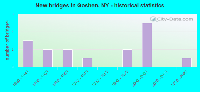
- New bridges - historical statistics
- 31940-1949
- 21950-1959
- 21960-1969
- 11970-1979
- 21990-1999
- 52000-2009
- 12020-2022

- Reconstructed bridges - Historical Statistics
- 21970-1979
- 01980-1989
- 01990-1999
- 22000-2009


- Bridge Condition - Deck
- 11.1%Excellent
- 11.1%Very good
- 33.3%Good
- 33.3%Satisfactory
- 11.1%Fair

- Bridge Condition - Superstructure
- 10.0%Excellent
- 30.0%Very good
- 20.0%Good
- 20.0%Satisfactory
- 20.0%Fair

- Bridge Condition - Substructure
- 10.0%Excellent
- 40.0%Very good
- 20.0%Good
- 10.0%Satisfactory
- 20.0%Fair
Find on map >> Show street view
Structure Number: 1003159, Location: 0.4 MI W JCT RTS 17 & 207 (Lat: 41.398417, Lng: -74.339736), Route carried "on" structure: State highway 17, Year Built: 1949, Year Reconstructed: 1975, Status: Open, Structure Length: 1.80m (5.91ft), Average Daily Traffic: 42,145 (year 2015), Truck Traffic: 8%, Average Future Daily Traffic: 59,453 (year 2040), Design Load: H 20, Features Intersected: RTE 17M
Minimum Vertical Clearance: 30+ m (98+ ft), Kilometerpoint: 19.630, Lanes on structure: 6, Lanes under structure: 2, Base Highway Network: Yes, Owner: State Highway Agency, Approaching Roadway Width: 29.3m (96.1ft), Skew: 33 degrees, Material/Design: Concrete, Design/Construction: Frame, Number Of Spans In Main Unit: 1, Length of Maximum Span: 15.2m (49.9ft), Curb or Sidewalk Widths: Left: 0.6m (2.0ft), Right: 0.6m (2.0ft), Curb-To-Curb Width: 28.7m (94.2ft), Out-to-Out Width: 32.7m (107.3ft)
Condition: Deck: Satisfactory, Superstructure: Satisfactory, Substructure: Fair, Operating Rating: 56.1 metric tons, Method Used To Determine Operating Rating: Field evaluation and documented engineering judgment, Inventory Rating: 20.8 metric tons, Method Used To Determine Inventory Rating: Field evaluation and documented engineering judgment, Structural Evaluation: Somewhat better than minimum adequacy, Deck Geometry: Better than present minimum criteria, Underclear: Meets minimum limits, Approach Roadway Alignment: Equal to present desirable criteria, Length Of Structure Improvement: 1.79m (5.87ft), Designated Inspection Frequency: Every 24 months, Inspection Date: August 2021, Bridge Improvement Cost: $4,532,000, Roadway Improvement Cost: $2,654,000, Total Project Cost: $7,186,000 ( Estimate for 2021)
Find on map >> Show street view
Structure Number: 100316, Location: JCT RTS 17 & 207 (Lat: 41.394358, Lng: -74.334214), Route carried "on" structure: State highway 207, Year Built: 1995, Status: Open, Structure Length: 6.80m (22.31ft), Average Daily Traffic: 8,454 (year 2020), Truck Traffic: 6%, Average Future Daily Traffic: 10,269 (year 2040), Design Load: HS 25 or greater, Features Intersected: 6 6 83011127 EB, RTE 6
Minimum Vertical Clearance: 30+ m (98+ ft), Kilometerpoint: 0.016, Lanes on structure: 4, Lanes under structure: 8, Base Highway Network: Yes, Owner: State Highway Agency, Approaching Roadway Width: 18.3m (60.0ft), Material/Design: Steel continuous, Design/Construction: Stringer/Multi-beam, Number Of Spans In Main Unit: 2, Length of Maximum Span: 33.8m (110.9ft), Curb-To-Curb Width: 18.3m (60.0ft), Out-to-Out Width: 19.1m (62.7ft)
Condition: Deck: Good, Superstructure: Fair, Substructure: Very good, Operating Rating: 59.6 metric tons, Method Used To Determine Operating Rating: Load and Resistance Factor Rating (LRFR) rating reported by rating factor(RF) method using HL-93 loadings, Inventory Rating: 46.0 metric tons, Method Used To Determine Inventory Rating: Load and Resistance Factor Rating (LRFR) rating reported by rating factor(RF) method using HL-93 loadings, Structural Evaluation: Somewhat better than minimum adequacy, Deck Geometry: Somewhat better than minimum adequacy, Underclear: Somewhat better than minimum adequacy, Approach Roadway Alignment: Equal to present desirable criteria, Length Of Structure Improvement: 6.79m (22.28ft), Designated Inspection Frequency: Every 24 months, Inspection Date: July 2020, Bridge Improvement Cost: $5,012,000, Roadway Improvement Cost: $2,935,000, Total Project Cost: $7,946,000 ( Estimate for 2021), Deck Structure Type: Concrete Cast-file-Place, Wearing Surface/Protective System: Wearing Surface: Integral Concrete, Deck Protection: Epoxy Coated Reinforcing
Find on map >> Show street view
Structure Number: 100317, Location: 1.1 MI SE JCT RTS 17+207 (Lat: 41.391475, Lng: -74.324081), Route carried "on" structure: Other road 17, Year Built: 2006, Status: Open, Structure Length: 5.15m (16.90ft), Average Daily Traffic: 2,344 (year 2020), Truck Traffic: 4%, Average Future Daily Traffic: 2,900 (year 2040), Design Load: HS 25 or greater, Features Intersected: 17 17 83101132 NB, RTE
Minimum Vertical Clearance: 30+ m (98+ ft), Kilometerpoint: 21.754, Lanes on structure: 2, Lanes under structure: 7, Base Highway Network: Yes, Owner: State Highway Agency, Approaching Roadway Width: 11.9m (39.0ft), Skew: 1 degrees, Material/Design: Prestressed concrete continuous, Design/Construction: Stringer/Multi-beam, Number Of Spans In Main Unit: 2, Length of Maximum Span: 24.7m (81.0ft), Curb or Sidewalk Widths: Left: 2.3m (7.5ft), Right: 2.3m (7.5ft), Curb-To-Curb Width: 12.0m (39.4ft), Out-to-Out Width: 17.1m (56.1ft)
Condition: Deck: Satisfactory, Superstructure: Good, Substructure: Very good, Operating Rating: 94.3 metric tons, Method Used To Determine Operating Rating: Load Factor (LF), Inventory Rating: 56.2 metric tons, Method Used To Determine Inventory Rating: Load Factor (LF), Structural Evaluation: Better than present minimum criteria, Deck Geometry: Somewhat better than minimum adequacy, Underclear: Meets minimum limits, Approach Roadway Alignment: Equal to present desirable criteria, Length Of Structure Improvement: 5.15m (16.90ft), Designated Inspection Frequency: Every 24 months, Inspection Date: July 2021, Bridge Improvement Cost: $3,288,000, Roadway Improvement Cost: $1,925,000, Total Project Cost: $5,213,000 ( Estimate for 2021), Deck Structure Type: Concrete Cast-file-Place, Wearing Surface/Protective System: Wearing Surface: Monolithic Concrete, Deck Protection: Epoxy Coated Reinforcing
Find on map >> Show street view
Structure Number: 1014001, Location: 0.6 MI W JCT RTS 17 + 207 (Lat: 41.401217, Lng: -74.340375), Route carried "on" structure: State highway 17, Year Built: 1951, Year Reconstructed: 2008, Status: Open, Structure Length: 3.17m (10.40ft), Average Daily Traffic: 21,073 (year 2015), Truck Traffic: 8%, Average Future Daily Traffic: 29,727 (year 2040), Design Load: HL 93, Features Intersected: ORANGE CO TRAILWAY
Minimum Vertical Clearance: 30+ m (98+ ft), Kilometerpoint: 19.324, Lanes on structure: 3, Base Highway Network: Yes, Owner: State Highway Agency, Approaching Roadway Width: 14.9m (48.9ft), Skew: 4 degrees, Material/Design: Steel, Design/Construction: Stringer/Multi-beam, Number Of Spans In Main Unit: 1, Length of Maximum Span: 29.3m (96.1ft), Curb-To-Curb Width: 15.2m (49.9ft), Out-to-Out Width: 16.2m (53.1ft)
Condition: Deck: Good, Superstructure: Very good, Substructure: Good, Operating Rating: 41.1 metric tons, Method Used To Determine Operating Rating: Load and Resistance Factor Rating (LRFR) rating reported by rating factor(RF) method using HL-93 loadings, Inventory Rating: 31.8 metric tons, Method Used To Determine Inventory Rating: Load and Resistance Factor Rating (LRFR) rating reported by rating factor(RF) method using HL-93 loadings, Structural Evaluation: Better than present minimum criteria, Deck Geometry: Meets minimum limits, Approach Roadway Alignment: Equal to present desirable criteria, Length Of Structure Improvement: 3.16m (10.37ft), Designated Inspection Frequency: Every 24 months, Inspection Date: March 2021, Bridge Improvement Cost: $4,947,000, Roadway Improvement Cost: $2,897,000, Total Project Cost: $7,844,000 ( Estimate for 2021), Deck Structure Type: Concrete Cast-file-Place, Wearing Surface/Protective System: Wearing Surface: Integral Concrete, Deck Protection: Other Coated Reinforcing
Find on map >> Show street view
Structure Number: 1014002, Location: 0.6 MI W JCT RTS.17 + 207 (Lat: 41.401308, Lng: -74.340622), Route carried "on" structure: Interstate 17, Year Built: 1951, Year Reconstructed: 2008, Status: Open, Structure Length: 3.17m (10.40ft), Average Daily Traffic: 21,073 (year 2015), Truck Traffic: 8%, Average Future Daily Traffic: 29,727 (year 2040), Design Load: HL 93, Features Intersected: ORANGE CO TRAILWAY
Minimum Vertical Clearance: 30+ m (98+ ft), Kilometerpoint: 19.324, Lanes on structure: 3, Base Highway Network: Yes, Owner: State Highway Agency, Approaching Roadway Width: 14.9m (48.9ft), Skew: 4 degrees, Material/Design: Steel, Design/Construction: Stringer/Multi-beam, Number Of Spans In Main Unit: 1, Length of Maximum Span: 29.3m (96.1ft), Curb-To-Curb Width: 15.2m (49.9ft), Out-to-Out Width: 16.2m (53.1ft)
Condition: Deck: Good, Superstructure: Very good, Substructure: Very good, Operating Rating: 41.1 metric tons, Method Used To Determine Operating Rating: Load and Resistance Factor Rating (LRFR) rating reported by rating factor(RF) method using HL-93 loadings, Inventory Rating: 31.8 metric tons, Method Used To Determine Inventory Rating: Load and Resistance Factor Rating (LRFR) rating reported by rating factor(RF) method using HL-93 loadings, Structural Evaluation: Better than present minimum criteria, Deck Geometry: Meets minimum limits, Approach Roadway Alignment: Equal to present desirable criteria, Length Of Structure Improvement: 3.16m (10.37ft), Designated Inspection Frequency: Every 24 months, Inspection Date: March 2021, Bridge Improvement Cost: $4,947,000, Roadway Improvement Cost: $2,897,000, Total Project Cost: $7,844,000 ( Estimate for 2021), Deck Structure Type: Concrete Cast-file-Place, Wearing Surface/Protective System: Wearing Surface: Integral Concrete, Deck Protection: Other Coated Reinforcing
Find on map >> Show street view
Structure Number: 1014019, Location: .5 MI W JCT SH 17 & SH207 (Lat: 41.399083, Lng: -74.340078), Route carried "on" structure: State highway 17, Year Built: 1949, Year Reconstructed: 1975, Status: Open, Structure Length: 1.62m (5.31ft), Average Daily Traffic: 42,145 (year 2015), Truck Traffic: 8%, Average Future Daily Traffic: 59,453 (year 2040), Design Load: H 20, Features Intersected: EX - ERIE RR ROW
Minimum Vertical Clearance: 30+ m (98+ ft), Kilometerpoint: 19.565, Lanes on structure: 6, Base Highway Network: Yes, Owner: State Highway Agency, Approaching Roadway Width: 30.5m (100.1ft), Skew: 31 degrees, Material/Design: Concrete, Design/Construction: Frame, Number Of Spans In Main Unit: 1, Length of Maximum Span: 12.8m (42.0ft), Curb or Sidewalk Widths: Left: 0.8m (2.6ft), Right: 0.8m (2.6ft), Curb-To-Curb Width: 30.4m (99.7ft), Out-to-Out Width: 32.9m (107.9ft)
Condition: Deck: Fair, Superstructure: Fair, Substructure: Fair, Operating Rating: 59.1 metric tons, Method Used To Determine Operating Rating: Field evaluation and documented engineering judgment, Inventory Rating: 24.6 metric tons, Method Used To Determine Inventory Rating: Field evaluation and documented engineering judgment, Structural Evaluation: Somewhat better than minimum adequacy, Deck Geometry: Superior to present desirable criteria, Approach Roadway Alignment: Equal to present desirable criteria, Length Of Structure Improvement: 1.61m (5.28ft), Designated Inspection Frequency: Every 24 months, Inspection Date: August 2021, Bridge Improvement Cost: $5,336,000, Roadway Improvement Cost: $3,125,000, Total Project Cost: $8,460,000 ( Estimate for 2021)
Find on map >> Show street view
Structure Number: 106001, Location: 1.3 MI NW EXIT 122A/SH 17 (Lat: 41.423656, Lng: -74.355194), Route carried "on" structure: Other road , Year Built: 1968, Status: Open, Structure Length: 5.76m (18.90ft), Average Daily Traffic: 1,974 (year 2015), Truck Traffic: 2%, Average Future Daily Traffic: 2,442 (year 2040), Design Load: H 20, Features Intersected: 17 17 83101102 SB, RTE, Facility Carried by Structure: PHILLIPSBURG ROAD
Minimum Vertical Clearance: 30+ m (98+ ft), Kilometerpoint: 2.349, Lanes on structure: 2, Lanes under structure: 4, Owner: State Highway Agency, Approaching Roadway Width: 9.8m (32.2ft), Material/Design: Steel, Design/Construction: Stringer/Multi-beam, Number Of Spans In Main Unit: 2, Length of Maximum Span: 28.9m (94.8ft), Curb or Sidewalk Widths: Left: 0.5m (1.6ft), Right: 0.5m (1.6ft), Curb-To-Curb Width: 7.3m (24.0ft), Out-to-Out Width: 8.8m (28.9ft)
Condition: Deck: Satisfactory, Superstructure: Satisfactory, Substructure: Satisfactory, Operating Rating: 75.3 metric tons, Method Used To Determine Operating Rating: Load Factor (LF), Inventory Rating: 45.4 metric tons, Method Used To Determine Inventory Rating: Load Factor (LF), Structural Evaluation: Equal to present minimum criteria, Deck Geometry: Meets minimum limits, Underclear: Somewhat better than minimum adequacy, Approach Roadway Alignment: Equal to present desirable criteria, Length Of Structure Improvement: 5.76m (18.90ft), Designated Inspection Frequency: Every 24 months, Inspection Date: June 2021, Bridge Improvement Cost: $2,000,000, Roadway Improvement Cost: $1,171,000, Total Project Cost: $3,171,000 ( Estimate for 2021), Deck Structure Type: Concrete Cast-file-Place, Wearing Surface/Protective System: Wearing Surface: Integral Concrete
Find on map >> Show street view
Structure Number: 106002, Location: IN GOSHEN-EXIT 122A/SH17 (Lat: 41.406942, Lng: -74.344639), Route carried "on" structure: Other road , Year Built: 2004, Status: Open, Structure Length: 5.64m (18.50ft), Average Daily Traffic: 4,983 (year 2018), Truck Traffic: 5%, Average Future Daily Traffic: 6,165 (year 2040), Design Load: HS 25 or greater, Features Intersected: 17 17 83101117 WB, RTE 1, Facility Carried by Structure: FLETCHER STREET
Minimum Vertical Clearance: 30+ m (98+ ft), Kilometerpoint: 0.177, Lanes on structure: 2, Lanes under structure: 6, Owner: State Highway Agency, Approaching Roadway Width: 9.1m (29.9ft), Material/Design: Steel, Design/Construction: Stringer/Multi-beam, Number Of Spans In Main Unit: 2, Length of Maximum Span: 27.7m (90.9ft), Curb-To-Curb Width: 9.6m (31.5ft), Out-to-Out Width: 10.8m (35.4ft)
Condition: Deck: Very good, Superstructure: Good, Substructure: Good, Operating Rating: 94.3 metric tons, Method Used To Determine Operating Rating: Load Factor (LF), Inventory Rating: 56.2 metric tons, Method Used To Determine Inventory Rating: Load Factor (LF), Structural Evaluation: Better than present minimum criteria, Deck Geometry: Meets minimum limits, Underclear: Somewhat better than minimum adequacy, Approach Roadway Alignment: Equal to present desirable criteria, Length Of Structure Improvement: 5.63m (18.47ft), Designated Inspection Frequency: Every 24 months, Inspection Date: September 2020, Bridge Improvement Cost: $2,359,000, Roadway Improvement Cost: $1,382,000, Total Project Cost: $3,741,000 ( Estimate for 2021), Deck Structure Type: Other, Wearing Surface/Protective System: Wearing Surface: Bituminous, Membrane: Other
Find on map >> Show street view
Structure Number: 108013, Location: Access rd to legoland, E (Lat: 41.383100, Lng: -74.306783), Route carried "on" structure: Ramp Other road 11, Year Built: 2020, Status: Open, Structure Length: 4.57m (14.99ft), Average Daily Traffic: 1,454 (year 2018), Truck Traffic: 8%, Average Future Daily Traffic: 2,032 (year 2040), Design Load: HL 93, Features Intersected: 17 17 83101144, 17 17 83
Minimum Vertical Clearance: 32.69m (107.25ft), Kilometerpoint: 2.928, Lanes on structure: 3, Lanes under structure: 5, Owner: State Highway Agency, Approaching Roadway Width: 17.7m (58.1ft), Skew: 20 degrees, Material/Design: Steel continuous, Design/Construction: Stringer/Multi-beam, Number Of Spans In Main Unit: 2, Length of Maximum Span: 23.8m (78.1ft), Curb-To-Curb Width: 17.6m (57.7ft), Out-to-Out Width: 18.6m (61.0ft)
Condition: Deck: Excellent, Superstructure: Excellent, Substructure: Excellent, Inventory Rating: 81.6 metric tons, Method Used To Determine Inventory Rating: Load Factor (LF), Structural Evaluation: Superior to present desirable criteria, Deck Geometry: Superior to present desirable criteria, Underclear: Somewhat better than minimum adequacy, Approach Roadway Alignment: Somewhat better than minimum adequacy, Length Of Structure Improvement: 4.57m (14.99ft), Designated Inspection Frequency: Every 24 months, Inspection Date: December 2020, Bridge Improvement Cost: $3,151,000, Roadway Improvement Cost: $1,845,000, Total Project Cost: $4,997,000 ( Estimate for 2021), Deck Structure Type: Concrete Cast-file-Place, Wearing Surface/Protective System: Wearing Surface: Monolithic Concrete, Deck Protection: Epoxy Coated Reinforcing
Find on map >> Show street view
Structure Number: 226221, Location: AT GOSHEN (Lat: 41.402575, Lng: -74.326528), Route carried "on" structure: Other road , Year Built: 1978, Status: Open, Structure Length: 1.01m (3.31ft), Truck Traffic: 1%, Design Load: HS 20, Features Intersected: RIO GRANDE, Facility Carried by Structure: CANAL STREET
Minimum Vertical Clearance: 30+ m (98+ ft), Kilometerpoint: 0.016, Lanes on structure: 2, Owner: Town or Township Highway Agency, Approaching Roadway Width: 9.1m (29.9ft), Skew: 4 degrees, Material/Design: Concrete, Design/Construction: Culvert, Number Of Spans In Main Unit: 2, Length of Maximum Span: 4.0m (13.1ft), Curb or Sidewalk Widths: Left: 1.2m (3.9ft), Right: 0.0m, Curb-To-Curb Width: 9.2m (30.2ft), Out-to-Out Width: 10.4m (34.1ft)
Condition: Channel: Satisfactory, Culverts: Fair, Operating Rating: 75.1 metric tons, Method Used To Determine Operating Rating: Field evaluation and documented engineering judgment, Inventory Rating: 29.4 metric tons, Method Used To Determine Inventory Rating: Field evaluation and documented engineering judgment, Structural Evaluation: Somewhat better than minimum adequacy, Deck Geometry: Better than present minimum criteria, Waterway Adequacy: Equal to present desirable criteria, Approach Roadway Alignment: Better than present minimum criteria, Length Of Structure Improvement: 1.00m (3.28ft), Designated Inspection Frequency: Every 24 months, Inspection Date: April 2020, Bridge Improvement Cost: $295,000, Roadway Improvement Cost: $173,000, Total Project Cost: $468,000 ( Estimate for 2021), Wearing Surface/Protective System: Wearing Surface: Bituminous
Find on map >> Show street view
Structure Number: 33446, Location: 2 MILES SE OF GOSHEN (Lat: 41.397689, Lng: -74.293153), Route carried "on" structure: County highway , Year Built: 2002, Status: Open, Structure Length: 1.25m (4.10ft), Average Daily Traffic: 2,083 (year 2015), Truck Traffic: 5%, Average Future Daily Traffic: 2,577 (year 2040), Design Load: HS 25 or greater, Features Intersected: OTTER KILL, Facility Carried by Structure: CRAIGVILLE RD CR-
Minimum Vertical Clearance: 30+ m (98+ ft), Kilometerpoint: 2.912, Lanes on structure: 2, Owner: County Highway Agency, Approaching Roadway Width: 9.8m (32.2ft), Skew: 2 degrees, Material/Design: Concrete, Design/Construction: Frame, Number Of Spans In Main Unit: 1, Length of Maximum Span: 11.3m (37.1ft), Curb-To-Curb Width: 9.1m (29.9ft), Out-to-Out Width: 10.1m (33.1ft)
Condition: Superstructure: Very good, Substructure: Very good, Channel: Satisfactory, Operating Rating: 70.7 metric tons, Method Used To Determine Operating Rating: Load Factor (LF), Inventory Rating: 42.3 metric tons, Method Used To Determine Inventory Rating: Load Factor (LF), Structural Evaluation: Equal to present desirable criteria, Deck Geometry: Meets minimum limits, Waterway Adequacy: Meets minimum limits, Approach Roadway Alignment: Better than present minimum criteria, Length Of Structure Improvement: 1.24m (4.07ft), Designated Inspection Frequency: Every 24 months, Inspection Date: March 2020, Bridge Improvement Cost: $819,000, Roadway Improvement Cost: $479,000, Total Project Cost: $1,298,000 ( Estimate for 2021), Wearing Surface/Protective System: Wearing Surface: Bituminous
Find on map >> Show street view
Structure Number: 1003159, Location: 0.4 MI W JCT RTS 17 & 207 (Lat: 41.398417, Lng: -74.339736), Route carried "under" structure: State highway 17M, Year Built: 1949, Structure Length: 0. m, Average Daily Traffic: 25,500 (year 1979), Features Intersected: RTE 17M, Facility Carried by Structure: RTE 17
Minimum Vertical Clearance: 4.65m (15.26ft), Kilometerpoint: 19.694, Lanes on structure: 6, Lanes under structure: 2, Material/Design: Concrete, Design/Construction: Frame, Length of Maximum Span: 15.2m (49.9ft)
Find on map >> Show street view
Structure Number: 100316, Location: JCT RTS 17 & 207 (Lat: 41.394358, Lng: -74.334214), Route carried "under" structure: US 6, Year Built: 1995, Structure Length: 0. m, Average Daily Traffic: 21,700 (year 2021), Features Intersected: 6 6 83011127 EB, RTE 6, Facility Carried by Structure: RTE 207
Minimum Vertical Clearance: 4.60m (15.09ft), Kilometerpoint: 20.225, Lanes on structure: 4, Lanes under structure: 4, Material/Design: Steel continuous, Design/Construction: Stringer/Multi-beam, Length of Maximum Span: 33.8m (110.9ft)
Find on map >> Show street view
Structure Number: 100317, Location: 1.1 MI SE JCT RTS 17+207 (Lat: 41.391475, Lng: -74.324081), Route carried "under" structure: US 17, Year Built: 2006, Structure Length: 0. m, Average Daily Traffic: 42,880 (year 1998), Features Intersected: 17 17 83101132 NB, RTE
Minimum Vertical Clearance: 6.43m (21.10ft), Kilometerpoint: 18.214, Lanes on structure: 2, Lanes under structure: 3, Material/Design: Prestressed concrete continuous, Design/Construction: Stringer/Multi-beam, Length of Maximum Span: 24.7m (81.0ft)
Find on map >> Show street view
Structure Number: 106001, Location: 1.3 MI NW EXIT 122A/SH 17 (Lat: 41.423656, Lng: -74.355194), Route carried "under" structure: State highway 17, Year Built: 1968, Structure Length: 0. m, Average Daily Traffic: 19,500 (year 1971), Features Intersected: 17 17 83101102 SB, RTE, Facility Carried by Structure: PHILLIPSBURG ROAD
Minimum Vertical Clearance: 5.00m (16.40ft), Kilometerpoint: 16.492, Lanes on structure: 2, Lanes under structure: 2, Material/Design: Steel, Design/Construction: Stringer/Multi-beam, Length of Maximum Span: 28.9m (94.8ft)
Find on map >> Show street view
Structure Number: 106002, Location: IN GOSHEN-EXIT 122A/SH17 (Lat: 41.406942, Lng: -74.344639), Route carried "under" structure: State highway 17, Year Built: 2004, Structure Length: 0. m, Average Daily Traffic: 19,500 (year 1971), Features Intersected: 17 17 83101117 WB, RTE 1, Facility Carried by Structure: FLETCHER STREET
Minimum Vertical Clearance: 5.28m (17.32ft), Kilometerpoint: 18.101, Lanes on structure: 2, Lanes under structure: 3, Material/Design: Steel, Design/Construction: Stringer/Multi-beam, Length of Maximum Span: 27.7m (90.9ft)