Bridge Statistics for Glen, New York (NY)
Condition, Traffic, Stress, Structural Evaluation, Project Costs
- National Bridge Inventory (NBI) Statistics
- 23Number of bridges
- 344ft / 105mTotal length
- $65,399,000Total costs
- 155,330Total average daily traffic
- 28,300Total average daily truck traffic
- National Bridge Inventory (NBI) Registered Bridges for Glen
- No street view available for this location
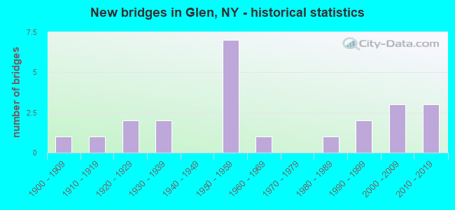
- New bridges - historical statistics
- 11900-1909
- 11910-1919
- 21920-1929
- 21930-1939
- 71950-1959
- 11960-1969
- 11980-1989
- 21990-1999
- 32000-2009
- 32010-2019

- Reconstructed bridges - Historical Statistics
- 11950-1959
- 11960-1969
- 01970-1979
- 41980-1989


- Bridge Condition - Deck
- 6.7%Excellent
- 26.7%Very good
- 20.0%Good
- 13.3%Satisfactory
- 33.3%Fair

- Bridge Condition - Superstructure
- 18.8%Excellent
- 37.5%Very good
- 12.5%Good
- 18.8%Satisfactory
- 12.5%Fair

- Bridge Condition - Substructure
- 18.8%Excellent
- 25.0%Very good
- 18.8%Good
- 31.3%Satisfactory
- 6.3%Fair

- Bridge Condition - Channel
- 25.0%Good
- 43.8%Satisfactory
- 18.8%Fair
- 12.5%Poor

- Bridge Condition - Culverts
- 33.3%Good
- 66.7%Satisfactory
Find on map >> Show street view
Structure Number: 100289, Location: 58MI E JCT RTS 162+5S (Lat: 42.924075, Lng: -74.422869), Route carried "on" structure: State highway 5S, Year Built: 1954, Status: Open, Structure Length: 1.34m (4.40ft), Average Daily Traffic: 1,706 (year 2020), Truck Traffic: 11%, Average Future Daily Traffic: 1,779 (year 2040), Design Load: H 20, Features Intersected: VAN WIE CREEK
Minimum Vertical Clearance: 30+ m (98+ ft), Kilometerpoint: 32.083, Lanes on structure: 2, Base Highway Network: Yes, Owner: State Highway Agency, Approaching Roadway Width: 7.9m (25.9ft), Material/Design: Concrete, Design/Construction: Culvert, Number Of Spans In Main Unit: 2, Length of Maximum Span: 6.0m (19.7ft), Curb-To-Curb Width: 9.1m (29.9ft), Out-to-Out Width: 13.2m (43.3ft)
Condition: Channel: Poor, Culverts: Satisfactory, Operating Rating: 33.4 metric tons, Method Used To Determine Operating Rating: Load and Resistance Factor Rating (LRFR) rating reported by rating factor(RF) method using HL-93 loadings, Inventory Rating: 25.6 metric tons, Method Used To Determine Inventory Rating: Load and Resistance Factor Rating (LRFR) rating reported by rating factor(RF) method using HL-93 loadings, Structural Evaluation: Equal to present minimum criteria, Deck Geometry: Somewhat better than minimum adequacy, Waterway Adequacy: Meets minimum limits, Approach Roadway Alignment: Equal to present desirable criteria, Length Of Structure Improvement: 1.34m (4.40ft), Designated Inspection Frequency: Every 24 months, Inspection Date: March 2020, Bridge Improvement Cost: $345,000, Roadway Improvement Cost: $202,000, Total Project Cost: $546,000 ( Estimate for 2021), Wearing Surface/Protective System: Wearing Surface: Bituminous
Find on map >> Show street view
Structure Number: 100291, Location: 2.9 MI E JCT RTS 5S & 30A (Lat: 42.930208, Lng: -74.316644), Route carried "on" structure: State highway 5S, Year Built: 1964, Status: Open, Structure Length: 5.15m (16.90ft), Average Daily Traffic: 4,848 (year 2020), Truck Traffic: 14%, Average Future Daily Traffic: 5,057 (year 2040), Design Load: H 20, Features Intersected: AURIES CREEK
Minimum Vertical Clearance: 30+ m (98+ ft), Kilometerpoint: 41.528, Lanes on structure: 2, Base Highway Network: Yes, Owner: State Highway Agency, Approaching Roadway Width: 8.5m (27.9ft), Skew: 2 degrees, Material/Design: Steel, Design/Construction: Stringer/Multi-beam, Number Of Spans In Main Unit: 1, Length of Maximum Span: 49.3m (161.7ft), Curb-To-Curb Width: 8.5m (27.9ft), Out-to-Out Width: 10.1m (33.1ft)
Condition: Deck: Satisfactory, Superstructure: Very good, Substructure: Satisfactory, Channel: Satisfactory, Operating Rating: 52.8 metric tons, Method Used To Determine Operating Rating: Load and Resistance Factor Rating (LRFR) rating reported by rating factor(RF) method using HL-93 loadings, Inventory Rating: 40.5 metric tons, Method Used To Determine Inventory Rating: Load and Resistance Factor Rating (LRFR) rating reported by rating factor(RF) method using HL-93 loadings, Structural Evaluation: Equal to present minimum criteria, Deck Geometry: Meets minimum limits, Waterway Adequacy: Meets minimum limits, Approach Roadway Alignment: Equal to present desirable criteria, Length Of Structure Improvement: 5.15m (16.90ft), Designated Inspection Frequency: Every 24 months, Inspection Date: July 2020, Bridge Improvement Cost: $970,000, Roadway Improvement Cost: $568,000, Total Project Cost: $1,539,000 ( Estimate for 2021), Deck Structure Type: Concrete Cast-file-Place, Wearing Surface/Protective System: Wearing Surface: Bituminous, Membrane: Other
Find on map >> Show street view
Structure Number: 10214, Location: 1 MI N JCT NY 30A &NY 161 (Lat: 42.908258, Lng: -74.350608), Route carried "on" structure: State highway 30A, Year Built: 2006, Status: Open, Structure Length: 2.80m (9.19ft), Average Daily Traffic: 2,230 (year 2020), Truck Traffic: 16%, Average Future Daily Traffic: 2,243 (year 2040), Design Load: HL 93, Features Intersected: AURIES CREEK
Minimum Vertical Clearance: 30+ m (98+ ft), Kilometerpoint: 15.688, Lanes on structure: 2, Base Highway Network: Yes, Owner: State Highway Agency, Approaching Roadway Width: 10.1m (33.1ft), Skew: 2 degrees, Material/Design: Prestressed concrete, Design/Construction: Stringer/Multi-beam, Number Of Spans In Main Unit: 1, Length of Maximum Span: 27.3m (89.6ft), Curb-To-Curb Width: 10.2m (33.5ft), Out-to-Out Width: 11.1m (36.4ft)
Condition: Deck: Very good, Superstructure: Excellent, Substructure: Excellent, Channel: Satisfactory, Operating Rating: 76.2 metric tons, Method Used To Determine Operating Rating: Load Factor (LF), Inventory Rating: 46.3 metric tons, Method Used To Determine Inventory Rating: Load Factor (LF), Structural Evaluation: Superior to present desirable criteria, Deck Geometry: Meets minimum limits, Waterway Adequacy: Somewhat better than minimum adequacy, Approach Roadway Alignment: Equal to present desirable criteria, Length Of Structure Improvement: 2.80m (9.19ft), Designated Inspection Frequency: Every 24 months, Inspection Date: May 2020, Bridge Improvement Cost: $816,000, Roadway Improvement Cost: $478,000, Total Project Cost: $1,294,000 ( Estimate for 2021), Deck Structure Type: Concrete Cast-file-Place, Wearing Surface/Protective System: Wearing Surface: Integral Concrete
Find on map >> Show street view
Structure Number: 103882, Location: 3.3 MI E JCT RTS 30A& 161 (Lat: 42.887406, Lng: -74.277944), Route carried "on" structure: State highway 161, Year Built: 1997, Status: Open, Structure Length: 14.17m (46.49ft), Average Daily Traffic: 1,737 (year 2020), Truck Traffic: 11%, Average Future Daily Traffic: 2,432 (year 2040), Design Load: HS 25 or greater, Features Intersected: SCHOHARIE CREEK
Minimum Vertical Clearance: 30+ m (98+ ft), Kilometerpoint: 5.889, Lanes on structure: 2, Base Highway Network: Yes, Owner: State Highway Agency, Approaching Roadway Width: 9.1m (29.9ft), Material/Design: Steel continuous, Design/Construction: Stringer/Multi-beam, Number Of Spans In Main Unit: 2, Length of Maximum Span: 70.1m (230.0ft), Curb-To-Curb Width: 8.7m (28.5ft), Out-to-Out Width: 9.8m (32.2ft)
Condition: Deck: Good, Superstructure: Very good, Substructure: Very good, Channel: Good, Operating Rating: 88.0 metric tons, Method Used To Determine Operating Rating: Load Factor (LF), Inventory Rating: 52.6 metric tons, Method Used To Determine Inventory Rating: Load Factor (LF), Structural Evaluation: Equal to present desirable criteria, Deck Geometry: Somewhat better than minimum adequacy, Waterway Adequacy: Equal to present minimum criteria, Approach Roadway Alignment: Equal to present desirable criteria, Length Of Structure Improvement: 14.17m (46.49ft), Designated Inspection Frequency: Every 24 months, Inspection Date: July 2021, Bridge Improvement Cost: $2,204,000, Roadway Improvement Cost: $1,290,000, Total Project Cost: $3,494,000 ( Estimate for 2021), Deck Structure Type: Concrete Cast-file-Place, Wearing Surface/Protective System: Wearing Surface: Bituminous, Membrane: Other, Deck Protection: Epoxy Coated Reinforcing
Find on map >> Show street view
Structure Number: 109424, Location: 33MI E JCT RTS 30A+5S (Lat: 42.929219, Lng: -74.310717), Route carried "on" structure: State highway 5S, Year Built: 1929, Year Reconstructed: 1962, Status: Open, Structure Length: 0.70m (2.30ft), Average Daily Traffic: 4,848 (year 2020), Truck Traffic: 14%, Average Future Daily Traffic: 5,057 (year 2040), Features Intersected: RAVINE CREEK
Minimum Vertical Clearance: 30+ m (98+ ft), Kilometerpoint: 42.043, Lanes on structure: 2, Base Highway Network: Yes, Owner: State Highway Agency, Approaching Roadway Width: 11.0m (36.1ft), Skew: 4 degrees, Material/Design: Steel, Design/Construction: Culvert, Number Of Spans In Main Unit: 2, Length of Maximum Span: 3.0m (9.8ft)
Condition: Channel: Poor, Culverts: Satisfactory, Operating Rating: 49.6 metric tons, Method Used To Determine Operating Rating: Field evaluation and documented engineering judgment, Inventory Rating: 24.5 metric tons, Method Used To Determine Inventory Rating: Field evaluation and documented engineering judgment, Structural Evaluation: Equal to present minimum criteria, Waterway Adequacy: Meets minimum limits, Approach Roadway Alignment: Equal to present desirable criteria, Length Of Structure Improvement: 0.70m (2.30ft), Designated Inspection Frequency: Every 24 months, Inspection Date: November 2021, Bridge Improvement Cost: $150,000, Roadway Improvement Cost: $88,000, Total Project Cost: $238,000 ( Estimate for 2021)
Find on map >> Show street view
Structure Number: 330996, Location: 3.2 MI SW OF FULTONVILLE (Lat: 42.923833, Lng: -74.419556), Route carried "on" structure: Other road , Year Built: 1934, Status: Open, Structure Length: 0.98m (3.22ft), Average Daily Traffic: 40 (year 2019), Truck Traffic: 4%, Average Future Daily Traffic: 56 (year 2039), Features Intersected: VAN WIE CREEK, Facility Carried by Structure: DILLENBECK ROAD
Minimum Vertical Clearance: 30+ m (98+ ft), Kilometerpoint: 1.352, Lanes on structure: 2, Owner: County Highway Agency, Approaching Roadway Width: 4.9m (16.1ft), Skew: 1 degrees, Material/Design: Steel, Design/Construction: Stringer/Multi-beam, Number Of Spans In Main Unit: 1, Length of Maximum Span: 9.1m (29.9ft), Curb-To-Curb Width: 6.1m (20.0ft), Out-to-Out Width: 7.2m (23.6ft)
Condition: Deck: Fair, Superstructure: Satisfactory, Substructure: Fair, Channel: Fair, Operating Rating: 66.5 metric tons, Method Used To Determine Operating Rating: Field evaluation and documented engineering judgment, Inventory Rating: 28.5 metric tons, Method Used To Determine Inventory Rating: Field evaluation and documented engineering judgment, Structural Evaluation: Somewhat better than minimum adequacy, Deck Geometry: Somewhat better than minimum adequacy, Waterway Adequacy: Meets minimum limits, Approach Roadway Alignment: Meets minimum limits, Length Of Structure Improvement: 0.97m (3.18ft), Designated Inspection Frequency: Every 24 months, Inspection Date: May 2021, Bridge Improvement Cost: $180,000, Roadway Improvement Cost: $105,000, Total Project Cost: $285,000 ( Estimate for 2021), Deck Structure Type: Concrete Cast-file-Place, Wearing Surface/Protective System: Wearing Surface: Bituminous
Find on map >> Show street view
Structure Number: 330998, Location: 2.0 MI SW OF GLEN (Lat: 42.879636, Lng: -74.381586), Route carried "on" structure: County highway , Year Built: 2003, Status: Open, Structure Length: 1.74m (5.71ft), Average Daily Traffic: 431 (year 2017), Truck Traffic: 8%, Average Future Daily Traffic: 603 (year 2037), Design Load: HS 25 or greater, Features Intersected: AURIES CREEK, Facility Carried by Structure: CR110 LOGTOWN ROAD
Minimum Vertical Clearance: 30+ m (98+ ft), Kilometerpoint: 6.790, Lanes on structure: 2, Owner: County Highway Agency, Approaching Roadway Width: 9.1m (29.9ft), Skew: 4 degrees, Material/Design: Prestressed concrete, Design/Construction: Box Beam or Girders - Multiple, Number Of Spans In Main Unit: 1, Length of Maximum Span: 16.0m (52.5ft), Curb-To-Curb Width: 9.1m (29.9ft), Out-to-Out Width: 10.2m (33.5ft)
Condition: Deck: Fair, Superstructure: Good, Substructure: Excellent, Channel: Satisfactory, Operating Rating: 86.2 metric tons, Method Used To Determine Operating Rating: Load Factor (LF), Inventory Rating: 51.7 metric tons, Method Used To Determine Inventory Rating: Load Factor (LF), Structural Evaluation: Better than present minimum criteria, Deck Geometry: Equal to present minimum criteria, Waterway Adequacy: Meets minimum limits, Approach Roadway Alignment: Better than present minimum criteria, Length Of Structure Improvement: 1.73m (5.68ft), Designated Inspection Frequency: Every 24 months, Inspection Date: May 2021, Bridge Improvement Cost: $421,000, Roadway Improvement Cost: $247,000, Total Project Cost: $667,000 ( Estimate for 2021), Deck Structure Type: Concrete Cast-file-Place, Wearing Surface/Protective System: Wearing Surface: Integral Concrete, Deck Protection: Epoxy Coated Reinforcing
Find on map >> Show street view
Structure Number: 330999, Location: 2 MI SW VILLAGE OF GLEN (Lat: 42.881989, Lng: -74.380592), Route carried "on" structure: Other road , Year Built: 1935, Status: Open, Structure Length: 1.01m (3.31ft), Average Daily Traffic: 129 (year 2016), Truck Traffic: 8%, Average Future Daily Traffic: 181 (year 2036), Features Intersected: AURIES CREEK, Facility Carried by Structure: HALL RD
Minimum Vertical Clearance: 30+ m (98+ ft), Kilometerpoint: 0.209, Lanes on structure: 2, Owner: County Highway Agency, Approaching Roadway Width: 4.3m (14.1ft), Material/Design: Steel, Design/Construction: Stringer/Multi-beam, Number Of Spans In Main Unit: 1, Length of Maximum Span: 9.4m (30.8ft), Curb-To-Curb Width: 5.0m (16.4ft), Out-to-Out Width: 5.7m (18.7ft)
Condition: Deck: Satisfactory, Superstructure: Satisfactory, Substructure: Satisfactory, Channel: Fair, Operating Rating: 65.8 metric tons, Method Used To Determine Operating Rating: Field evaluation and documented engineering judgment, Inventory Rating: 28.1 metric tons, Method Used To Determine Inventory Rating: Field evaluation and documented engineering judgment, Structural Evaluation: Equal to present minimum criteria, Deck Geometry: High priority of replacement, Waterway Adequacy: Meets minimum limits, Approach Roadway Alignment: Meets minimum limits, Length Of Structure Improvement: 1.00m (3.28ft), Designated Inspection Frequency: Every 24 months, Inspection Date: June 2021, Bridge Improvement Cost: $174,000, Roadway Improvement Cost: $102,000, Total Project Cost: $276,000 ( Estimate for 2021), Deck Structure Type: Concrete Cast-file-Place, Wearing Surface/Protective System: Wearing Surface: Bituminous
Find on map >> Show street view
Structure Number: 331, Location: 1.5 MILES WEST OF GLEN (Lat: 42.886558, Lng: -74.371450), Route carried "on" structure: County highway , Year Built: 2003, Status: Open, Structure Length: 2.01m (6.59ft), Average Daily Traffic: 431 (year 2017), Truck Traffic: 8%, Average Future Daily Traffic: 603 (year 2037), Design Load: HS 25 or greater, Features Intersected: CORNISH CREEK, Facility Carried by Structure: CR110 LOGTOWN ROAD
Minimum Vertical Clearance: 30+ m (98+ ft), Kilometerpoint: 8.061, Lanes on structure: 2, Owner: County Highway Agency, Approaching Roadway Width: 9.1m (29.9ft), Skew: 2 degrees, Material/Design: Prestressed concrete, Design/Construction: Box Beam or Girders - Multiple, Number Of Spans In Main Unit: 1, Length of Maximum Span: 19.0m (62.3ft), Curb-To-Curb Width: 9.1m (29.9ft), Out-to-Out Width: 10.2m (33.5ft)
Condition: Deck: Fair, Superstructure: Very good, Substructure: Good, Channel: Good, Operating Rating: 98.9 metric tons, Method Used To Determine Operating Rating: Load Factor (LF), Inventory Rating: 59.0 metric tons, Method Used To Determine Inventory Rating: Load Factor (LF), Structural Evaluation: Better than present minimum criteria, Deck Geometry: Equal to present minimum criteria, Waterway Adequacy: Somewhat better than minimum adequacy, Approach Roadway Alignment: Equal to present desirable criteria, Length Of Structure Improvement: 2.01m (6.59ft), Designated Inspection Frequency: Every 24 months, Inspection Date: June 2021, Bridge Improvement Cost: $435,000, Roadway Improvement Cost: $254,000, Total Project Cost: $689,000 ( Estimate for 2021), Deck Structure Type: Concrete Cast-file-Place, Wearing Surface/Protective System: Wearing Surface: Integral Concrete, Deck Protection: Epoxy Coated Reinforcing
Find on map >> Show street view
Structure Number: 331001, Location: .7 MILE NW OF GLEN (Lat: 42.898492, Lng: -74.355944), Route carried "on" structure: County highway , Year Built: 1923, Year Reconstructed: 1965, Status: Open, Structure Length: 1.49m (4.89ft), Average Daily Traffic: 181 (year 2017), Truck Traffic: 1%, Average Future Daily Traffic: 253 (year 2037), Features Intersected: AURIES CREEK, Facility Carried by Structure: CR118 FISHER ROAD
Minimum Vertical Clearance: 30+ m (98+ ft), Kilometerpoint: 3.540, Lanes on structure: 2, Owner: County Highway Agency, Approaching Roadway Width: 4.6m (15.1ft), Material/Design: Steel, Design/Construction: Stringer/Multi-beam, Number Of Spans In Main Unit: 1, Length of Maximum Span: 14.6m (47.9ft), Curb-To-Curb Width: 7.3m (24.0ft), Out-to-Out Width: 8.6m (28.2ft)
Condition: Deck: Fair, Superstructure: Fair, Substructure: Satisfactory, Channel: Fair, Operating Rating: 22.4 metric tons, Method Used To Determine Operating Rating: Load and Resistance Factor Rating (LRFR) rating reported by rating factor(RF) method using HL-93 loadings, Inventory Rating: 17.2 metric tons, Method Used To Determine Inventory Rating: Load and Resistance Factor Rating (LRFR) rating reported by rating factor(RF) method using HL-93 loadings, Structural Evaluation: Somewhat better than minimum adequacy, Deck Geometry: Somewhat better than minimum adequacy, Waterway Adequacy: Meets minimum limits, Approach Roadway Alignment: Equal to present desirable criteria, Length Of Structure Improvement: 1.49m (4.89ft), Designated Inspection Frequency: Every 24 months, Inspection Date: July 2021, Bridge Improvement Cost: $352,000, Roadway Improvement Cost: $206,000, Total Project Cost: $558,000 ( Estimate for 2021), Deck Structure Type: Concrete Cast-file-Place, Wearing Surface/Protective System: Wearing Surface: Bituminous
Find on map >> Show street view
Structure Number: 331006, Location: 2.0 MI W OF GLEN (Lat: 42.884117, Lng: -74.295311), Route carried "on" structure: Other road , Year Built: 2010, Status: Open, Structure Length: 2.96m (9.71ft), Average Daily Traffic: 197 (year 2019), Truck Traffic: 1%, Average Future Daily Traffic: 276 (year 2039), Design Load: HL 93, Features Intersected: IRISH CREEK, Facility Carried by Structure: ROUND BARN ROAD
Minimum Vertical Clearance: 30+ m (98+ ft), Kilometerpoint: 1.529, Lanes on structure: 2, Owner: County Highway Agency, Approaching Roadway Width: 9.1m (29.9ft), Skew: 5 degrees, Material/Design: Prestressed concrete, Design/Construction: Box Beam or Girders - Multiple, Number Of Spans In Main Unit: 1, Length of Maximum Span: 27.4m (89.9ft), Curb-To-Curb Width: 9.1m (29.9ft), Out-to-Out Width: 10.1m (33.1ft)
Condition: Deck: Good, Superstructure: Very good, Substructure: Very good, Channel: Satisfactory, Operating Rating: 67.1 metric tons, Method Used To Determine Operating Rating: Load Factor (LF), Inventory Rating: 39.9 metric tons, Method Used To Determine Inventory Rating: Load Factor (LF), Structural Evaluation: Equal to present desirable criteria, Deck Geometry: Equal to present minimum criteria, Waterway Adequacy: Somewhat better than minimum adequacy, Approach Roadway Alignment: Equal to present desirable criteria, Length Of Structure Improvement: 2.95m (9.68ft), Designated Inspection Frequency: Every 24 months, Inspection Date: April 2021, Bridge Improvement Cost: $812,000, Roadway Improvement Cost: $475,000, Total Project Cost: $1,287,000 ( Estimate for 2021), Deck Structure Type: Concrete Cast-file-Place, Wearing Surface/Protective System: Wearing Surface: Monolithic Concrete, Deck Protection: Epoxy Coated Reinforcing
Find on map >> Show street view
Structure Number: 331012, Location: 5.8 MI SW OF FULTONVILLE (Lat: 42.884286, Lng: -74.279892), Route carried "on" structure: County highway , Year Built: 1910, Year Reconstructed: 1991, Status: Open, Structure Length: 0.73m (2.40ft), Average Daily Traffic: 313 (year 2017), Average Future Daily Traffic: 438 (year 2037), Features Intersected: IRISH CREEK, Facility Carried by Structure: CR129 HUGHES ROAD
Minimum Vertical Clearance: 30+ m (98+ ft), Kilometerpoint: 9.123, Lanes on structure: 2, Owner: County Highway Agency, Approaching Roadway Width: 5.5m (18.0ft), Material/Design: Masonry, Design/Construction: Arch - Deck, Number Of Spans In Main Unit: 1, Length of Maximum Span: 7.0m (23.0ft), Curb-To-Curb Width: 7.2m (23.6ft), Out-to-Out Width: 12.1m (39.7ft)
Condition: Superstructure: Fair, Substructure: Satisfactory, Channel: Satisfactory, Operating Rating: 52.5 metric tons, Method Used To Determine Operating Rating: Field evaluation and documented engineering judgment, Inventory Rating: 24.5 metric tons, Method Used To Determine Inventory Rating: Field evaluation and documented engineering judgment, Structural Evaluation: Somewhat better than minimum adequacy, Deck Geometry: Meets minimum limits, Waterway Adequacy: Meets minimum limits, Approach Roadway Alignment: Somewhat better than minimum adequacy, Length Of Structure Improvement: 0.73m (2.40ft), Designated Inspection Frequency: Every 24 months, Inspection Date: May 2021, Bridge Improvement Cost: $128,000, Roadway Improvement Cost: $75,000, Total Project Cost: $203,000 ( Estimate for 2021), Deck Structure Type: Concrete Cast-file-Place, Wearing Surface/Protective System: Wearing Surface: Bituminous
Find on map >> Show street view
Structure Number: 5002939, Location: 0.6 MI E JCT RTS 5S & 288 (Lat: 42.931067, Lng: -74.288322), Route carried "on" structure: Interstate 90, Year Built: 1953, Status: Open, Structure Length: 10.24m (33.60ft), Average Daily Traffic: 19,863 (year 2020), Truck Traffic: 31%, Average Future Daily Traffic: 22,093 (year 2040), Design Load: HS 20, Features Intersected: RTE 5S, OLD RR (BIKE/PED
Minimum Vertical Clearance: 30+ m (98+ ft), Kilometerpoint: 45.004, Lanes on structure: 4, Lanes under structure: 2, Base Highway Network: Yes, Toll: On Interstate toll segment, Owner: State Toll Authority, Approaching Roadway Width: 33.5m (109.9ft), Skew: 34 degrees, Material/Design: Steel, Design/Construction: Stringer/Multi-beam, Number Of Spans In Main Unit: 4, Length of Maximum Span: 26.5m (86.9ft), Curb-To-Curb Width: 32.7m (107.3ft), Out-to-Out Width: 34.5m (113.2ft)
Condition: Deck: Fair, Superstructure: Satisfactory, Substructure: Satisfactory, Operating Rating: 81.6 metric tons, Method Used To Determine Operating Rating: Load Factor (LF), Inventory Rating: 49.0 metric tons, Method Used To Determine Inventory Rating: Load Factor (LF), Structural Evaluation: Equal to present minimum criteria, Deck Geometry: Superior to present desirable criteria, Underclear: High priority of corrective action, Approach Roadway Alignment: Equal to present desirable criteria, Length Of Structure Improvement: 10.24m (33.60ft), Designated Inspection Frequency: Every 24 months, Inspection Date: July 2021, Bridge Improvement Cost: $5,801,000, Roadway Improvement Cost: $3,397,000, Total Project Cost: $9,198,000 ( Estimate for 2021), Deck Structure Type: Concrete Cast-file-Place, Wearing Surface/Protective System: Wearing Surface: Bituminous, Membrane: Other
Find on map >> Show street view
Structure Number: 5515869, Location: 90IX OVER SCHOHARIE CR (Lat: 42.931650, Lng: -74.278639), Route carried "on" structure: Interstate 90, Year Built: 1988, Status: Open, Structure Length: 22.04m (72.31ft), Average Daily Traffic: 19,863 (year 2020), Truck Traffic: 31%, Average Future Daily Traffic: 22,093 (year 2040), Design Load: HS 20+Mod, Features Intersected: SCHOHARIE CREEK
Minimum Vertical Clearance: 30+ m (98+ ft), Kilometerpoint: 45.776, Lanes on structure: 4, Base Highway Network: Yes, Toll: On Interstate toll segment, Owner: State Toll Authority, Approaching Roadway Width: 34.4m (112.9ft), Skew: 20 degrees, Material/Design: Steel continuous, Design/Construction: Stringer/Multi-beam, Number Of Spans In Main Unit: 4, Length of Maximum Span: 61.9m (203.1ft), Curb-To-Curb Width: 33.0m (108.3ft), Out-to-Out Width: 35.0m (114.8ft)
Condition: Deck: Good, Superstructure: Very good, Substructure: Very good, Channel: Satisfactory, Operating Rating: 68.0 metric tons, Method Used To Determine Operating Rating: Load and Resistance Factor Rating (LRFR) rating reported by rating factor(RF) method using HL-93 loadings, Inventory Rating: 52.5 metric tons, Method Used To Determine Inventory Rating: Load and Resistance Factor Rating (LRFR) rating reported by rating factor(RF) method using HL-93 loadings, Structural Evaluation: Equal to present desirable criteria, Deck Geometry: Superior to present desirable criteria, Waterway Adequacy: Superior to present desirable criteria, Approach Roadway Alignment: Equal to present desirable criteria, Length Of Structure Improvement: 22.03m (72.28ft), Designated Inspection Frequency: Every 24 months, Underwater Inspection Frequency: Every 60 months, Inspection Date: June 2020, Underwater Inspection Date: September 2021, Bridge Improvement Cost: $12,530,000, Roadway Improvement Cost: $7,337,000, Total Project Cost: $19,867,000 ( Estimate for 2021), Deck Structure Type: Concrete Cast-file-Place, Wearing Surface/Protective System: Wearing Surface: Bituminous, Membrane: Epoxy, Deck Protection: Epoxy Coated Reinforcing
Find on map >> Show street view
Structure Number: 551587, Location: 1 MI SW OF FORT HUNTER (Lat: 42.932117, Lng: -74.315639), Route carried "on" structure: Interstate 90, Year Built: 1991, Status: Open, Structure Length: 2.13m (6.99ft), Average Daily Traffic: 19,863 (year 2020), Truck Traffic: 31%, Average Future Daily Traffic: 22,093 (year 2040), Design Load: HS 20+Mod, Features Intersected: AURIES CREEK
Minimum Vertical Clearance: 30+ m (98+ ft), Kilometerpoint: 42.799, Lanes on structure: 4, Base Highway Network: Yes, Toll: On Interstate toll segment, Owner: State Toll Authority, Approaching Roadway Width: 35.4m (116.1ft), Skew: 30 degrees, Material/Design: Steel, Design/Construction: Stringer/Multi-beam, Number Of Spans In Main Unit: 1, Length of Maximum Span: 20.1m (65.9ft), Curb-To-Curb Width: 34.5m (113.2ft), Out-to-Out Width: 35.4m (116.1ft)
Condition: Deck: Very good, Superstructure: Good, Substructure: Good, Channel: Satisfactory, Operating Rating: 86.2 metric tons, Method Used To Determine Operating Rating: Load Factor (LF), Inventory Rating: 41.7 metric tons, Method Used To Determine Inventory Rating: Load Factor (LF), Structural Evaluation: Better than present minimum criteria, Deck Geometry: Superior to present desirable criteria, Waterway Adequacy: High priority of corrective action, Approach Roadway Alignment: Equal to present desirable criteria, Length Of Structure Improvement: 2.13m (6.99ft), Designated Inspection Frequency: Every 24 months, Inspection Date: April 2021, Bridge Improvement Cost: $2,234,000, Roadway Improvement Cost: $1,308,000, Total Project Cost: $3,541,000 ( Estimate for 2021), Deck Structure Type: Concrete Cast-file-Place, Wearing Surface/Protective System: Wearing Surface: Bituminous, Membrane: Other, Deck Protection: Epoxy Coated Reinforcing
Find on map >> Show street view
Structure Number: 551588, Location: 1.2 MI SE OF FULTONVILLE (Lat: 42.940853, Lng: -74.342931), Route carried "on" structure: State highway 920P, Year Built: 1955, Year Reconstructed: 1994, Status: Open, Structure Length: 12.53m (41.11ft), Average Daily Traffic: 1,238 (year 2020), Truck Traffic: 29%, Average Future Daily Traffic: 1,531 (year 2040), Design Load: HS 25 or greater, Features Intersected: 90IX WB, RTE I90, Bike P
Minimum Vertical Clearance: 30+ m (98+ ft), Kilometerpoint: 2.430, Lanes on structure: 2, Lanes under structure: 6, Base Highway Network: Yes, Owner: State Toll Authority, Approaching Roadway Width: 9.8m (32.2ft), Skew: 2 degrees, Material/Design: Steel, Design/Construction: Stringer/Multi-beam, Number Of Spans In Main Unit: 5, Length of Maximum Span: 25.9m (85.0ft), Curb-To-Curb Width: 9.8m (32.2ft), Out-to-Out Width: 10.7m (35.1ft)
Condition: Deck: Very good, Superstructure: Excellent, Substructure: Good, Operating Rating: 71.9 metric tons, Method Used To Determine Operating Rating: Load and Resistance Factor Rating (LRFR) rating reported by rating factor(RF) method using HL-93 loadings, Inventory Rating: 55.4 metric tons, Method Used To Determine Inventory Rating: Load and Resistance Factor Rating (LRFR) rating reported by rating factor(RF) method using HL-93 loadings, Structural Evaluation: Better than present minimum criteria, Deck Geometry: Somewhat better than minimum adequacy, Underclear: High priority of corrective action, Approach Roadway Alignment: Equal to present desirable criteria, Length Of Structure Improvement: 12.52m (41.08ft), Designated Inspection Frequency: Every 24 months, Inspection Date: August 2020, Bridge Improvement Cost: $2,089,000, Roadway Improvement Cost: $1,223,000, Total Project Cost: $3,312,000 ( Estimate for 2021), Deck Structure Type: Concrete Cast-file-Place, Wearing Surface/Protective System: Wearing Surface: Integral Concrete, Deck Protection: Galvanized Reinforcing
Find on map >> Show street view
Structure Number: 551589, Location: EXIT 28 OF I90 (Lat: 42.944847, Lng: -74.359708), Route carried "on" structure: Ramp Other road , Year Built: 2010, Status: Open, Structure Length: 6.58m (21.59ft), Average Daily Traffic: 1,435 (year 2018), Truck Traffic: 28%, Average Future Daily Traffic: 1,653 (year 2040), Design Load: HS 25 or greater, Features Intersected: 90IX, RTE I90, Facility Carried by Structure: FULTONVILLE INT.
Minimum Vertical Clearance: 30+ m (98+ ft), Kilometerpoint: 0.097, Lanes on structure: 2, Lanes under structure: 5, Toll: On Interstate toll segment, Owner: State Toll Authority, Approaching Roadway Width: 16.2m (53.1ft), Skew: 30 degrees, Material/Design: Steel continuous, Design/Construction: Stringer/Multi-beam, Number Of Spans In Main Unit: 2, Length of Maximum Span: 33.5m (109.9ft), Curb-To-Curb Width: 14.7m (48.2ft), Out-to-Out Width: 16.2m (53.1ft)
Condition: Deck: Excellent, Superstructure: Excellent, Substructure: Excellent, Operating Rating: 73.5 metric tons, Method Used To Determine Operating Rating: Load Factor (LF), Inventory Rating: 43.5 metric tons, Method Used To Determine Inventory Rating: Load Factor (LF), Structural Evaluation: Superior to present desirable criteria, Deck Geometry: Superior to present desirable criteria, Underclear: Somewhat better than minimum adequacy, Approach Roadway Alignment: Meets minimum limits, Length Of Structure Improvement: 6.58m (21.59ft), Designated Inspection Frequency: Every 24 months, Inspection Date: November 2020, Bridge Improvement Cost: $1,772,000, Roadway Improvement Cost: $1,038,000, Total Project Cost: $2,809,000 ( Estimate for 2021), Deck Structure Type: Concrete Cast-file-Place, Wearing Surface/Protective System: Wearing Surface: Integral Concrete, Deck Protection: Galvanized Reinforcing
Find on map >> Show street view
Structure Number: 55159, Location: 1.5 MI NE OF RANDALL (Lat: 42.926703, Lng: -74.423797), Route carried "on" structure: Interstate 90, Year Built: 1955, Year Reconstructed: 1992, Status: Open, Structure Length: 1.04m (3.41ft), Average Daily Traffic: 19,439 (year 2020), Truck Traffic: 32%, Average Future Daily Traffic: 21,621 (year 2040), Design Load: HS 20+Mod, Features Intersected: VAN WIE CREEK
Minimum Vertical Clearance: 30+ m (98+ ft), Kilometerpoint: 32.872, Lanes on structure: 4, Base Highway Network: Yes, Toll: On Interstate toll segment, Owner: State Toll Authority, Approaching Roadway Width: 25.0m (82.0ft), Skew: 30 degrees, Material/Design: Concrete, Design/Construction: Culvert, Number Of Spans In Main Unit: 1, Length of Maximum Span: 9.1m (29.9ft), Curb-To-Curb Width: 34.2m (112.2ft), Out-to-Out Width: 37.9m (124.3ft)
Condition: Channel: Good, Culverts: Good, Operating Rating: 78.4 metric tons, Method Used To Determine Operating Rating: Field evaluation and documented engineering judgment, Inventory Rating: 29.4 metric tons, Method Used To Determine Inventory Rating: Field evaluation and documented engineering judgment, Structural Evaluation: Better than present minimum criteria, Deck Geometry: Superior to present desirable criteria, Waterway Adequacy: Equal to present minimum criteria, Approach Roadway Alignment: Equal to present desirable criteria, Length Of Structure Improvement: 1.03m (3.38ft), Designated Inspection Frequency: Every 24 months, Inspection Date: March 2021, Bridge Improvement Cost: $1,666,000, Roadway Improvement Cost: $976,000, Total Project Cost: $2,642,000 ( Estimate for 2021)
Find on map >> Show street view
Structure Number: 552361, Location: 5.1 MI E JCT SH5S & SH30A (Lat: 42.937289, Lng: -74.280861), Route carried "on" structure: State highway 5S, Year Built: 1909, Year Reconstructed: 1987, Status: Open, Structure Length: 15.21m (49.90ft), Average Daily Traffic: 4,848 (year 2020), Truck Traffic: 14%, Average Future Daily Traffic: 5,057 (year 2040), Design Load: HS 20, Features Intersected: SCHOHARIE CREEK
Minimum Vertical Clearance: 6.83m (22.41ft), Kilometerpoint: 44.859, Lanes on structure: 2, Base Highway Network: Yes, Owner: State Agenciy, Approaching Roadway Width: 7.0m (23.0ft), Material/Design: Steel, Design/Construction: Truss - Thru, Number Of Spans In Main Unit: 2, Number Of Approach Spans: 2, Length of Maximum Span: 49.6m (162.7ft), Curb-To-Curb Width: 7.1m (23.3ft), Out-to-Out Width: 8.7m (28.5ft)
Condition: Deck: Very good, Superstructure: Very good, Substructure: Very good, Channel: Good, Inventory Rating: 72.6 metric tons, Method Used To Determine Inventory Rating: Load Factor (LF), Structural Evaluation: Equal to present desirable criteria, Deck Geometry: High priority of replacement, Waterway Adequacy: Somewhat better than minimum adequacy, Approach Roadway Alignment: Equal to present desirable criteria, Length Of Structure Improvement: 15.20m (49.87ft), Designated Inspection Frequency: Every 24 months, Critical Feature Inspection Frequency: Every 24 months, Inspection Date: September 2021, Critical Feature Inspection Date: September 2021, Bridge Improvement Cost: $8,170,000, Roadway Improvement Cost: $4,784,000, Total Project Cost: $12,954,000 ( Estimate for 2021), Deck Structure Type: Concrete Cast-file-Place, Wearing Surface/Protective System: Wearing Surface: Integral Concrete, Deck Protection: Epoxy Coated Reinforcing
Find on map >> Show street view
Structure Number: 5002939, Location: 0.6 MI E JCT RTS 5S & 288 (Lat: 42.931067, Lng: -74.288322), Route carried "under" structure: State highway 5S, Year Built: 1953, Structure Length: 0. m, Average Daily Traffic: 5,503 (year 1999), Features Intersected: RTE 5S, OLD RR (BIKE/PED, Facility Carried by Structure: RTE I90
Minimum Vertical Clearance: 8.23m (27.00ft), Kilometerpoint: 17.956, Lanes on structure: 4, Lanes under structure: 2, Material/Design: Steel, Design/Construction: Stringer/Multi-beam, Length of Maximum Span: 26.5m (86.9ft)
Find on map >> Show street view
Structure Number: 551588, Location: 1.2 MI SE OF FULTONVILLE (Lat: 42.940853, Lng: -74.342931), Route carried "under" structure: Interstate 90, Year Built: 1955, Structure Length: 0. m, Average Daily Traffic: 23,285 (year 2014), Features Intersected: 90IX WB, RTE I90, Bike P, Facility Carried by Structure: RTE 920P
Minimum Vertical Clearance: 10.06m (33.01ft), Kilometerpoint: 291.663, Lanes on structure: 2, Lanes under structure: 2, Toll: On Interstate toll segment, Material/Design: Steel, Design/Construction: Stringer/Multi-beam, Length of Maximum Span: 25.9m (85.0ft)
Find on map >> Show street view
Structure Number: 551588, Location: 1.2 MI SE OF FULTONVILLE (Lat: 42.940853, Lng: -74.342931), Route carried "under" structure: Interstate , Year Built: 1955, Structure Length: 0. m, Average Daily Traffic: 100 (year 2016), Features Intersected: 90IX WB, RTE I90, Bike P, Facility Carried by Structure: RTE 920P
Minimum Vertical Clearance: 5.56m (18.24ft), Kilometerpoint: 291.663, Lanes on structure: 2, Lanes under structure: 2, Material/Design: Steel, Design/Construction: Stringer/Multi-beam, Length of Maximum Span: 25.9m (85.0ft)
Find on map >> Show street view
Structure Number: 551589, Location: EXIT 28 OF I90 (Lat: 42.944847, Lng: -74.359708), Route carried "under" structure: Interstate 90, Year Built: 2010, Structure Length: 0. m, Average Daily Traffic: 22,802 (year 2014), Features Intersected: 90IX, RTE I90, Facility Carried by Structure: FULTONVILLE INT.
Minimum Vertical Clearance: 5.16m (16.93ft), Kilometerpoint: 293.112, Lanes on structure: 2, Lanes under structure: 3, Toll: On Interstate toll segment, Material/Design: Steel continuous, Design/Construction: Stringer/Multi-beam, Length of Maximum Span: 33.5m (109.9ft)