Bridge Statistics for Gallatin, New York (NY)
Condition, Traffic, Stress, Structural Evaluation, Project Costs
- National Bridge Inventory (NBI) Statistics
- 14Number of bridges
- 52ft / 16.4mTotal length
- $18,815,000Total costs
- 17,548Total average daily traffic
- 341Total average daily truck traffic
- National Bridge Inventory (NBI) Registered Bridges for Gallatin
- No street view available for this location
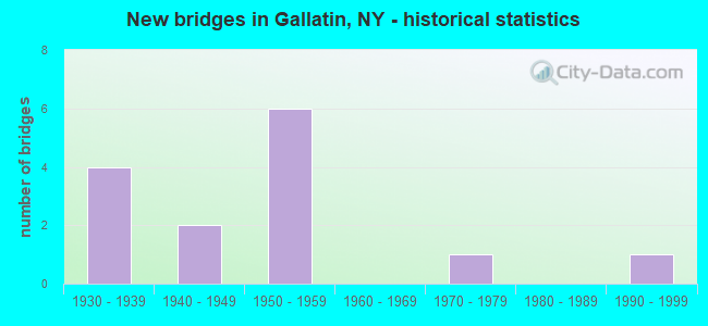
- New bridges - historical statistics
- 41930-1939
- 21940-1949
- 61950-1959
- 11970-1979
- 11990-1999


- Bridge Condition - Deck
- 18.2%Satisfactory
- 54.5%Fair
- 27.3%Poor

- Bridge Condition - Superstructure
- 36.4%Satisfactory
- 45.5%Fair
- 9.1%Poor
- 9.1%Serious

- Bridge Condition - Substructure
- 36.4%Satisfactory
- 54.5%Fair
- 9.1%Poor

- Bridge Condition - Channel
- 10.0%Good
- 40.0%Satisfactory
- 40.0%Fair
- 10.0%Poor
Find on map >> Show street view
Structure Number: 226292, Location: 1.9 MILES EAST OF MT ROSS (Lat: 42.005092, Lng: -73.679006), Route carried "on" structure: Other road , Year Built: 1973, Status: Open, Structure Length: 0.64m (2.10ft), Average Daily Traffic: 642 (year 2020), Truck Traffic: 8%, Average Future Daily Traffic: 899 (year 2040), Features Intersected: UNNAMED STREAM, Facility Carried by Structure: SILVERNAILS ROAD
Minimum Vertical Clearance: 30+ m (98+ ft), Kilometerpoint: 2.462, Lanes on structure: 2, Owner: Town or Township Highway Agency, Approaching Roadway Width: 5.8m (19.0ft), Skew: 1 degrees, Material/Design: Steel, Design/Construction: Culvert, Number Of Spans In Main Unit: 1, Length of Maximum Span: 6.0m (19.7ft)
Condition: Channel: Poor, Culverts: Satisfactory, Operating Rating: 76.9 metric tons, Method Used To Determine Operating Rating: Field evaluation and documented engineering judgment, Inventory Rating: 32.7 metric tons, Method Used To Determine Inventory Rating: Field evaluation and documented engineering judgment, Structural Evaluation: Equal to present minimum criteria, Waterway Adequacy: Meets minimum limits, Approach Roadway Alignment: Equal to present minimum criteria, Length Of Structure Improvement: 0.64m (2.10ft), Designated Inspection Frequency: Every 24 months, Inspection Date: December 2021, Bridge Improvement Cost: $104,000, Roadway Improvement Cost: $61,000, Total Project Cost: $165,000 ( Estimate for 2021)
Find on map >> Show street view
Structure Number: 322241, Location: 0.7 MI E OF MT ROSS (Lat: 42.004164, Lng: -73.701825), Route carried "on" structure: County highway , Year Built: 1991, Status: Open, Structure Length: 2.23m (7.32ft), Average Daily Traffic: 884 (year 2014), Truck Traffic: 9%, Average Future Daily Traffic: 1,238 (year 2034), Design Load: HS 20, Features Intersected: HAMM BROOK, Facility Carried by Structure: COUNTY ROAD 50
Minimum Vertical Clearance: 30+ m (98+ ft), Kilometerpoint: 1.657, Lanes on structure: 2, Owner: County Highway Agency, Approaching Roadway Width: 7.3m (24.0ft), Skew: 5 degrees, Material/Design: Prestressed concrete, Design/Construction: Box Beam or Girders - Multiple, Number Of Spans In Main Unit: 1, Length of Maximum Span: 21.3m (69.9ft), Curb-To-Curb Width: 7.3m (24.0ft), Out-to-Out Width: 7.9m (25.9ft)
Condition: Deck: Satisfactory, Superstructure: Satisfactory, Substructure: Satisfactory, Channel: Satisfactory, Operating Rating: 89.8 metric tons, Method Used To Determine Operating Rating: Load Factor (LF), Inventory Rating: 54.4 metric tons, Method Used To Determine Inventory Rating: Load Factor (LF), Structural Evaluation: Equal to present minimum criteria, Deck Geometry: Meets minimum limits, Waterway Adequacy: Somewhat better than minimum adequacy, Approach Roadway Alignment: Equal to present desirable criteria, Length Of Structure Improvement: 2.22m (7.28ft), Designated Inspection Frequency: Every 24 months, Inspection Date: May 2021, Bridge Improvement Cost: $1,580,000, Roadway Improvement Cost: $925,000, Total Project Cost: $2,506,000 ( Estimate for 2021), Deck Structure Type: Concrete Cast-file-Place, Wearing Surface/Protective System: Wearing Surface: Integral Concrete
Find on map >> Show street view
Structure Number: 322247, Location: 1.6 MI SW OF GALLATINVILL (Lat: 42.015144, Lng: -73.688275), Route carried "on" structure: Other road , Year Built: 1932, Status: Open, Structure Length: 1.65m (5.41ft), Average Daily Traffic: 642 (year 2020), Truck Traffic: 8%, Average Future Daily Traffic: 899 (year 2040), Features Intersected: ROELIFF JANSEN KL, Facility Carried by Structure: PINE PLAINS-SILVER
Minimum Vertical Clearance: 30+ m (98+ ft), Kilometerpoint: 1.014, Lanes on structure: 2, Owner: County Highway Agency, Approaching Roadway Width: 7.3m (24.0ft), Skew: 1 degrees, Material/Design: Steel, Design/Construction: Stringer/Multi-beam, Number Of Spans In Main Unit: 1, Length of Maximum Span: 15.8m (51.8ft), Curb-To-Curb Width: 6.6m (21.7ft), Out-to-Out Width: 7.4m (24.3ft)
Condition: Deck: Poor, Superstructure: Poor, Substructure: Poor, Channel: Fair, Operating Rating: 30.8 metric tons, Method Used To Determine Operating Rating: Load and Resistance Factor Rating (LRFR) rating reported by rating factor(RF) method using HL-93 loadings, Inventory Rating: 23.7 metric tons, Method Used To Determine Inventory Rating: Load and Resistance Factor Rating (LRFR) rating reported by rating factor(RF) method using HL-93 loadings, Structural Evaluation: Meets minimum limits, Deck Geometry: High priority of corrective action, Waterway Adequacy: Meets minimum limits, Approach Roadway Alignment: Somewhat better than minimum adequacy, Length Of Structure Improvement: 1.64m (5.38ft), Designated Inspection Frequency: Every 24 months, Inspection Date: April 2020, Bridge Improvement Cost: $657,000, Roadway Improvement Cost: $385,000, Total Project Cost: $1,042,000 ( Estimate for 2021), Deck Structure Type: Concrete Cast-file-Place, Wearing Surface/Protective System: Wearing Surface: Bituminous
Find on map >> Show street view
Structure Number: 322248, Location: AT SNYDERVILLE (Lat: 42.084758, Lng: -73.765267), Route carried "on" structure: Other road , Year Built: 1931, Status: Open, Structure Length: 0.88m (2.89ft), Average Daily Traffic: 205 (year 2020), Truck Traffic: 8%, Average Future Daily Traffic: 287 (year 2040), Features Intersected: DOVER KILL, Facility Carried by Structure: TAGHKANIC ROAD
Minimum Vertical Clearance: 30+ m (98+ ft), Kilometerpoint: 0.080, Lanes on structure: 2, Owner: County Highway Agency, Approaching Roadway Width: 6.7m (22.0ft), Skew: 1 degrees, Material/Design: Steel, Design/Construction: Stringer/Multi-beam, Number Of Spans In Main Unit: 1, Length of Maximum Span: 8.5m (27.9ft), Curb-To-Curb Width: 6.1m (20.0ft), Out-to-Out Width: 6.8m (22.3ft)
Condition: Deck: Fair, Superstructure: Satisfactory, Substructure: Fair, Channel: Satisfactory, Operating Rating: 52.2 metric tons, Method Used To Determine Operating Rating: Load and Resistance Factor Rating (LRFR) rating reported by rating factor(RF) method using HL-93 loadings, Inventory Rating: 40.5 metric tons, Method Used To Determine Inventory Rating: Load and Resistance Factor Rating (LRFR) rating reported by rating factor(RF) method using HL-93 loadings, Structural Evaluation: Somewhat better than minimum adequacy, Deck Geometry: Meets minimum limits, Waterway Adequacy: Superior to present desirable criteria, Approach Roadway Alignment: Somewhat better than minimum adequacy, Length Of Structure Improvement: 0.88m (2.89ft), Designated Inspection Frequency: Every 24 months, Inspection Date: August 2020, Bridge Improvement Cost: $492,000, Roadway Improvement Cost: $288,000, Total Project Cost: $781,000 ( Estimate for 2021), Deck Structure Type: Concrete Cast-file-Place, Wearing Surface/Protective System: Wearing Surface: Bituminous
Find on map >> Show street view
Structure Number: 322249, Location: 0.5 MI W OF GALLATINVILLE (Lat: 42.030475, Lng: -73.677950), Route carried "on" structure: Other road , Year Built: 1933, Status: Open, Structure Length: 1.83m (6.00ft), Average Daily Traffic: 125 (year 2020), Truck Traffic: 8%, Average Future Daily Traffic: 175 (year 2040), Design Load: H 20, Features Intersected: ROELIFF JANSEN KL, Facility Carried by Structure: SLVNLS-GALTNVL RD
Minimum Vertical Clearance: 30+ m (98+ ft), Kilometerpoint: 0.322, Lanes on structure: 2, Owner: County Highway Agency, Approaching Roadway Width: 7.9m (25.9ft), Skew: 3 degrees, Material/Design: Steel, Design/Construction: Stringer/Multi-beam, Number Of Spans In Main Unit: 1, Length of Maximum Span: 17.6m (57.7ft), Curb-To-Curb Width: 6.1m (20.0ft), Out-to-Out Width: 6.9m (22.6ft)
Condition: Deck: Poor, Superstructure: Fair, Substructure: Fair, Channel: Satisfactory, Operating Rating: 41.7 metric tons, Method Used To Determine Operating Rating: Load Factor (LF), Inventory Rating: 25.4 metric tons, Method Used To Determine Inventory Rating: Load Factor (LF), Structural Evaluation: Somewhat better than minimum adequacy, Deck Geometry: Meets minimum limits, Waterway Adequacy: Meets minimum limits, Approach Roadway Alignment: Somewhat better than minimum adequacy, Length Of Structure Improvement: 1.82m (5.97ft), Designated Inspection Frequency: Every 24 months, Inspection Date: September 2020, Bridge Improvement Cost: $969,000, Roadway Improvement Cost: $568,000, Total Project Cost: $1,537,000 ( Estimate for 2021), Deck Structure Type: Concrete Cast-file-Place, Wearing Surface/Protective System: Wearing Surface: Bituminous
Find on map >> Show street view
Structure Number: 32225, Location: AT GALLATINVILLE (Lat: 42.033264, Lng: -73.670083), Route carried "on" structure: Other road , Year Built: 1948, Status: Open, Structure Length: 2.19m (7.19ft), Average Daily Traffic: 153 (year 2020), Truck Traffic: 8%, Average Future Daily Traffic: 214 (year 2040), Features Intersected: ROELIFF JANSEN KL, Facility Carried by Structure: MILL HILL ROAD
Minimum Vertical Clearance: 30+ m (98+ ft), Kilometerpoint: 0.145, Lanes on structure: 2, Owner: County Highway Agency, Approaching Roadway Width: 6.7m (22.0ft), Material/Design: Steel, Design/Construction: Stringer/Multi-beam, Number Of Spans In Main Unit: 1, Length of Maximum Span: 21.3m (69.9ft), Curb-To-Curb Width: 6.1m (20.0ft), Out-to-Out Width: 6.3m (20.7ft)
Condition: Deck: Poor, Superstructure: Fair, Substructure: Fair, Channel: Good, Operating Rating: 20.4 metric tons, Method Used To Determine Operating Rating: Load and Resistance Factor Rating (LRFR) rating reported by rating factor(RF) method using HL-93 loadings, Inventory Rating: 15.6 metric tons, Method Used To Determine Inventory Rating: Load and Resistance Factor Rating (LRFR) rating reported by rating factor(RF) method using HL-93 loadings, Structural Evaluation: Meets minimum limits, Deck Geometry: Meets minimum limits, Waterway Adequacy: Somewhat better than minimum adequacy, Approach Roadway Alignment: Somewhat better than minimum adequacy, Length Of Structure Improvement: 2.19m (7.19ft), Designated Inspection Frequency: Every 24 months, Inspection Date: October 2021, Bridge Improvement Cost: $792,000, Roadway Improvement Cost: $464,000, Total Project Cost: $1,256,000 ( Estimate for 2021), Deck Structure Type: Open Grating, Wearing Surface/Protective System: Wearing Surface: Other
Find on map >> Show street view
Structure Number: 334232, Location: 0.6 MI E OF JACKSON CORS (Lat: 42.015597, Lng: -73.732581), Route carried "on" structure: County highway , Year Built: 1936, Status: Open, Structure Length: 1.16m (3.81ft), Truck Traffic: 3%, Features Intersected: FALL KILL, Facility Carried by Structure: COUNTY ROAD 2
Minimum Vertical Clearance: 30+ m (98+ ft), Kilometerpoint: 1.529, Lanes on structure: 2, Owner: County Highway Agency, Approaching Roadway Width: 8.5m (27.9ft), Skew: 3 degrees, Material/Design: Steel, Design/Construction: Stringer/Multi-beam, Number Of Spans In Main Unit: 1, Length of Maximum Span: 10.9m (35.8ft), Curb-To-Curb Width: 8.5m (27.9ft), Out-to-Out Width: 12.6m (41.3ft)
Condition: Deck: Fair, Superstructure: Satisfactory, Substructure: Satisfactory, Channel: Fair, Operating Rating: 11.0 metric tons, Method Used To Determine Operating Rating: Load and Resistance Factor Rating (LRFR) rating reported by rating factor(RF) method using HL-93 loadings, Inventory Rating: 8.4 metric tons, Method Used To Determine Inventory Rating: Load and Resistance Factor Rating (LRFR) rating reported by rating factor(RF) method using HL-93 loadings, Structural Evaluation: High priority of corrective action, Deck Geometry: Better than present minimum criteria, Waterway Adequacy: Meets minimum limits, Approach Roadway Alignment: Better than present minimum criteria, Length Of Structure Improvement: 1.15m (3.77ft), Designated Inspection Frequency: Every 24 months, Inspection Date: October 2020, Bridge Improvement Cost: $1,008,000, Roadway Improvement Cost: $590,000, Total Project Cost: $1,598,000 ( Estimate for 2021), Deck Structure Type: Concrete Cast-file-Place, Wearing Surface/Protective System: Wearing Surface: Bituminous
Find on map >> Show street view
Structure Number: 334244, Location: 1.4 MI SW OF ANACRAM (Lat: 42.037944, Lng: -73.656753), Route carried "on" structure: County highway , Year Built: 1953, Status: Posted for load, Structure Length: 0.94m (3.08ft), Average Daily Traffic: 765 (year 2020), Truck Traffic: 9%, Average Future Daily Traffic: 1,071 (year 2040), Features Intersected: TRIB ROE_JAN KILL, Facility Carried by Structure: COUNTY ROAD 7
Minimum Vertical Clearance: 30+ m (98+ ft), Kilometerpoint: 4.023, Lanes on structure: 2, Owner: County Highway Agency, Approaching Roadway Width: 7.9m (25.9ft), Skew: 2 degrees, Material/Design: Steel, Design/Construction: Stringer/Multi-beam, Number Of Spans In Main Unit: 1, Length of Maximum Span: 8.8m (28.9ft), Curb-To-Curb Width: 7.0m (23.0ft), Out-to-Out Width: 8.8m (28.9ft)
Condition: Deck: Fair, Superstructure: Serious, Substructure: Fair, Channel: Fair, Operating Rating: 14.6 metric tons, Method Used To Determine Operating Rating: Load and Resistance Factor Rating (LRFR) rating reported by rating factor(RF) method using HL-93 loadings, Inventory Rating: 11.3 metric tons, Method Used To Determine Inventory Rating: Load and Resistance Factor Rating (LRFR) rating reported by rating factor(RF) method using HL-93 loadings, Structural Evaluation: High priority of corrective action, Deck Geometry: Meets minimum limits, Waterway Adequacy: Equal to present desirable criteria, Approach Roadway Alignment: Somewhat better than minimum adequacy, Bridge Posting: Required (Relationship of Operating Rating to Maximum Legal Load: > 39.9% below), Length Of Structure Improvement: 0.94m (3.08ft), Designated Inspection Frequency: Every 12 months, Inspection Date: April 2021, Bridge Improvement Cost: $602,000, Roadway Improvement Cost: $352,000, Total Project Cost: $954,000 ( Estimate for 2021), Deck Structure Type: Concrete Cast-file-Place, Wearing Surface/Protective System: Wearing Surface: Bituminous
Find on map >> Show street view
Structure Number: 334257, Location: 0.9 MI SW OF L TAGHKANIC (Lat: 42.075889, Lng: -73.726233), Route carried "on" structure: County highway , Year Built: 1948, Status: Open, Structure Length: 0.88m (2.89ft), Average Daily Traffic: 694 (year 2017), Truck Traffic: 4%, Average Future Daily Traffic: 972 (year 2037), Design Load: H 20, Features Intersected: DOVER KILL, Facility Carried by Structure: COUNTY ROAD 8
Minimum Vertical Clearance: 30+ m (98+ ft), Kilometerpoint: 6.452, Lanes on structure: 2, Owner: County Highway Agency, Approaching Roadway Width: 7.9m (25.9ft), Skew: 1 degrees, Material/Design: Concrete, Design/Construction: Slab, Number Of Spans In Main Unit: 1, Length of Maximum Span: 8.5m (27.9ft), Curb-To-Curb Width: 7.9m (25.9ft), Out-to-Out Width: 9.4m (30.8ft)
Condition: Deck: Satisfactory, Superstructure: Satisfactory, Substructure: Satisfactory, Channel: Fair, Operating Rating: 49.0 metric tons, Method Used To Determine Operating Rating: Load Factor (LF), Inventory Rating: 29.0 metric tons, Method Used To Determine Inventory Rating: Load Factor (LF), Structural Evaluation: Equal to present minimum criteria, Deck Geometry: Somewhat better than minimum adequacy, Waterway Adequacy: Superior to present desirable criteria, Approach Roadway Alignment: Equal to present minimum criteria, Length Of Structure Improvement: 0.88m (2.89ft), Designated Inspection Frequency: Every 24 months, Inspection Date: August 2020, Bridge Improvement Cost: $355,000, Roadway Improvement Cost: $208,000, Total Project Cost: $562,000 ( Estimate for 2021), Wearing Surface/Protective System: Wearing Surface: Bituminous
Find on map >> Show street view
Structure Number: 334258, Location: 0.9 MI SE OF SNYDERVILLE (Lat: 42.080069, Lng: -73.748447), Route carried "on" structure: County highway , Year Built: 1951, Status: Open, Structure Length: 0.91m (2.99ft), Average Daily Traffic: 694 (year 2017), Truck Traffic: 4%, Average Future Daily Traffic: 972 (year 2037), Design Load: H 20, Features Intersected: DOVER KILL, Facility Carried by Structure: COUNTY ROAD 8
Minimum Vertical Clearance: 30+ m (98+ ft), Kilometerpoint: 6.870, Lanes on structure: 2, Owner: County Highway Agency, Approaching Roadway Width: 6.7m (22.0ft), Skew: 2 degrees, Material/Design: Concrete, Design/Construction: Slab, Number Of Spans In Main Unit: 1, Length of Maximum Span: 8.5m (27.9ft), Curb-To-Curb Width: 7.1m (23.3ft), Out-to-Out Width: 8.9m (29.2ft)
Condition: Deck: Fair, Superstructure: Fair, Substructure: Fair, Channel: Satisfactory, Operating Rating: 56.2 metric tons, Method Used To Determine Operating Rating: Load Factor (LF), Inventory Rating: 33.6 metric tons, Method Used To Determine Inventory Rating: Load Factor (LF), Structural Evaluation: Somewhat better than minimum adequacy, Deck Geometry: Meets minimum limits, Waterway Adequacy: Superior to present desirable criteria, Approach Roadway Alignment: Better than present minimum criteria, Length Of Structure Improvement: 0.91m (2.99ft), Designated Inspection Frequency: Every 24 months, Inspection Date: August 2020, Bridge Improvement Cost: $401,000, Roadway Improvement Cost: $235,000, Total Project Cost: $636,000 ( Estimate for 2021), Wearing Surface/Protective System: Wearing Surface: Bituminous
Find on map >> Show street view
Structure Number: 5502489, Location: 0.4 MI E OF JACKSON CORS (Lat: 42.015989, Lng: -73.735911), Route carried "on" structure: State highway 987G, Year Built: 1951, Status: Open, Structure Length: 1.52m (4.99ft), Average Daily Traffic: 6,322 (year 2020), Average Future Daily Traffic: 15,165 (year 2040), Design Load: H 20, Features Intersected: COUNTY ROAD 2
Minimum Vertical Clearance: 30+ m (98+ ft), Kilometerpoint: 0.032, Lanes on structure: 4, Lanes under structure: 2, Base Highway Network: Yes, Owner: State Highway Agency, Approaching Roadway Width: 17.1m (56.1ft), Skew: 32 degrees, Material/Design: Concrete, Design/Construction: Frame, Number Of Spans In Main Unit: 1, Length of Maximum Span: 14.6m (47.9ft), Curb-To-Curb Width: 21.0m (68.9ft), Out-to-Out Width: 22.3m (73.2ft)
Condition: Deck: Fair, Superstructure: Fair, Substructure: Fair, Operating Rating: 56.5 metric tons, Method Used To Determine Operating Rating: Field evaluation and documented engineering judgment, Inventory Rating: 21.0 metric tons, Method Used To Determine Inventory Rating: Field evaluation and documented engineering judgment, Structural Evaluation: Somewhat better than minimum adequacy, Deck Geometry: Superior to present desirable criteria, Underclear: Meets minimum limits, Approach Roadway Alignment: Equal to present desirable criteria, Length Of Structure Improvement: 1.52m (4.99ft), Designated Inspection Frequency: Every 24 months, Inspection Date: September 2021, Bridge Improvement Cost: $2,468,000, Roadway Improvement Cost: $1,445,000, Total Project Cost: $3,913,000 ( Estimate for 2021)
Find on map >> Show street view
Structure Number: 5502499, Location: 0.7 MI S OF L TAGHKANIC (Lat: 42.073597, Lng: -73.717061), Route carried "on" structure: State highway 987G, Year Built: 1951, Status: Open, Structure Length: 1.58m (5.18ft), Average Daily Traffic: 6,322 (year 2020), Average Future Daily Traffic: 15,165 (year 2040), Features Intersected: COUNTY ROAD 8
Minimum Vertical Clearance: 30+ m (98+ ft), Kilometerpoint: 6.935, Lanes on structure: 4, Lanes under structure: 2, Base Highway Network: Yes, Owner: State Highway Agency, Approaching Roadway Width: 21.0m (68.9ft), Skew: 32 degrees, Material/Design: Concrete, Design/Construction: Frame, Number Of Spans In Main Unit: 1, Length of Maximum Span: 14.6m (47.9ft), Curb-To-Curb Width: 17.1m (56.1ft), Out-to-Out Width: 22.4m (73.5ft)
Condition: Deck: Fair, Superstructure: Fair, Substructure: Satisfactory, Operating Rating: 54.5 metric tons, Method Used To Determine Operating Rating: Field evaluation and documented engineering judgment, Inventory Rating: 14.1 metric tons, Method Used To Determine Inventory Rating: Field evaluation and documented engineering judgment, Structural Evaluation: High priority of corrective action, Deck Geometry: Somewhat better than minimum adequacy, Underclear: Somewhat better than minimum adequacy, Approach Roadway Alignment: Equal to present desirable criteria, Length Of Structure Improvement: 1.58m (5.18ft), Designated Inspection Frequency: Every 24 months, Inspection Date: June 2021, Bridge Improvement Cost: $2,438,000, Roadway Improvement Cost: $1,427,000, Total Project Cost: $3,865,000 ( Estimate for 2021)
Find on map >> Show street view
Structure Number: 5502489, Location: 0.4 MI E OF JACKSON CORS (Lat: 42.015989, Lng: -73.735911), Route carried "under" structure: County highway , Year Built: 1951, Structure Length: 0. m, Features Intersected: COUNTY ROAD 2, Facility Carried by Structure: RTE 987G
Minimum Vertical Clearance: 5.03m (16.50ft), Kilometerpoint: 1.802, Lanes on structure: 4, Lanes under structure: 2, Material/Design: Concrete, Design/Construction: Frame, Length of Maximum Span: 14.6m (47.9ft)
Find on map >> Show street view
Structure Number: 5502499, Location: 0.7 MI S OF L TAGHKANIC (Lat: 42.073597, Lng: -73.717061), Route carried "under" structure: County highway , Year Built: 1951, Structure Length: 0. m, Average Daily Traffic: 100 (year 2021), Features Intersected: COUNTY ROAD 8, Facility Carried by Structure: RTE 987G
Minimum Vertical Clearance: 4.52m (14.83ft), Kilometerpoint: 0.000, Lanes on structure: 4, Lanes under structure: 2, Material/Design: Concrete, Design/Construction: Frame, Length of Maximum Span: 14.6m (47.9ft)