Bridge Statistics for Fort Plain, New York (NY)
Condition, Traffic, Stress, Structural Evaluation, Project Costs
- National Bridge Inventory (NBI) Statistics
- 10Number of bridges
- 141ft / 42.8mTotal length
- $41,852,000Total costs
- 84,156Total average daily traffic
- 19,427Total average daily truck traffic
- National Bridge Inventory (NBI) Registered Bridges for Fort Plain
- No street view available for this location
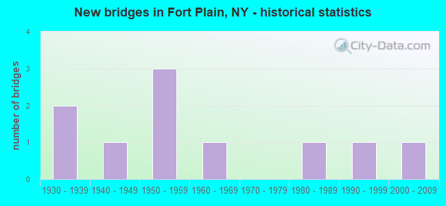
- New bridges - historical statistics
- 21930-1939
- 11940-1949
- 31950-1959
- 11960-1969
- 11980-1989
- 11990-1999
- 12000-2009

- Reconstructed bridges - Historical Statistics
- 11960-1969
- 01970-1979
- 31980-1989


- Bridge Condition - Deck
- 50.0%Good
- 25.0%Satisfactory
- 12.5%Fair
- 12.5%Poor

- Bridge Condition - Superstructure
- 25.0%Excellent
- 25.0%Good
- 12.5%Satisfactory
- 37.5%Fair

- Bridge Condition - Substructure
- 12.5%Excellent
- 12.5%Very good
- 12.5%Good
- 25.0%Satisfactory
- 37.5%Fair

- Bridge Condition - Channel
- 20.0%Excellent
- 20.0%Very good
- 40.0%Good
- 20.0%Fair
Find on map >> Show street view
Structure Number: 10028, Location: 0.2 MI S JCT RTS 5S & 80 (Lat: 42.930481, Lng: -74.621922), Route carried "on" structure: State highway 5S, Year Built: 1931, Year Reconstructed: 1989, Status: Open, Structure Length: 3.96m (12.99ft), Average Daily Traffic: 3,019 (year 2020), Truck Traffic: 10%, Average Future Daily Traffic: 3,735 (year 2040), Design Load: HS 20, Features Intersected: OTSQUAGO CREEK
Minimum Vertical Clearance: 4.49m (14.73ft), Kilometerpoint: 12.180, Lanes on structure: 2, Base Highway Network: Yes, Owner: State Highway Agency, Approaching Roadway Width: 9.1m (29.9ft), Material/Design: Steel, Design/Construction: Truss - Thru, Number Of Spans In Main Unit: 1, Length of Maximum Span: 38.1m (125.0ft), Curb or Sidewalk Widths: Left: 1.7m (5.6ft), Right: 1.7m (5.6ft), Curb-To-Curb Width: 9.1m (29.9ft), Out-to-Out Width: 10.1m (33.1ft)
Condition: Deck: Good, Superstructure: Fair, Substructure: Fair, Channel: Good, Operating Rating: 62.6 metric tons, Method Used To Determine Operating Rating: Load Factor (LF), Inventory Rating: 37.2 metric tons, Method Used To Determine Inventory Rating: Load Factor (LF), Structural Evaluation: Somewhat better than minimum adequacy, Deck Geometry: Meets minimum limits, Waterway Adequacy: Meets minimum limits, Approach Roadway Alignment: Equal to present desirable criteria, Length Of Structure Improvement: 3.96m (12.99ft), Designated Inspection Frequency: Every 24 months, Critical Feature Inspection Frequency: Every 12 months, Inspection Date: August 2021, Critical Feature Inspection Date: August 2021, Bridge Improvement Cost: $3,703,000, Roadway Improvement Cost: $2,169,000, Total Project Cost: $5,872,000 ( Estimate for 2021), Deck Structure Type: Concrete Cast-file-Place, Wearing Surface/Protective System: Wearing Surface: Integral Concrete, Deck Protection: Epoxy Coated Reinforcing
Find on map >> Show street view
Structure Number: 103095, Location: 05MI W JCT RTS 5S+80 (Lat: 42.929367, Lng: -74.632711), Route carried "on" structure: State highway 80, Year Built: 1967, Status: Open, Structure Length: 3.93m (12.89ft), Average Daily Traffic: 1,808 (year 2020), Truck Traffic: 8%, Average Future Daily Traffic: 2,237 (year 2040), Design Load: HS 20, Features Intersected: OTSQUAGO CREEK
Minimum Vertical Clearance: 30+ m (98+ ft), Kilometerpoint: 10.523, Lanes on structure: 2, Base Highway Network: Yes, Owner: State Highway Agency, Approaching Roadway Width: 9.1m (29.9ft), Skew: 4 degrees, Material/Design: Steel, Design/Construction: Stringer/Multi-beam, Number Of Spans In Main Unit: 1, Length of Maximum Span: 37.1m (121.7ft), Curb or Sidewalk Widths: Left: 1.5m (4.9ft), Right: 1.5m (4.9ft), Curb-To-Curb Width: 9.1m (29.9ft), Out-to-Out Width: 12.9m (42.3ft)
Condition: Deck: Fair, Superstructure: Good, Substructure: Fair, Channel: Fair, Operating Rating: 58.1 metric tons, Method Used To Determine Operating Rating: Load Factor (LF), Inventory Rating: 34.5 metric tons, Method Used To Determine Inventory Rating: Load Factor (LF), Structural Evaluation: Somewhat better than minimum adequacy, Deck Geometry: Somewhat better than minimum adequacy, Waterway Adequacy: Meets minimum limits, Approach Roadway Alignment: Equal to present desirable criteria, Length Of Structure Improvement: 3.93m (12.89ft), Designated Inspection Frequency: Every 24 months, Inspection Date: August 2021, Bridge Improvement Cost: $1,274,000, Roadway Improvement Cost: $746,000, Total Project Cost: $2,020,000 ( Estimate for 2021), Deck Structure Type: Concrete Cast-file-Place, Wearing Surface/Protective System: Wearing Surface: Latex Concrete
Find on map >> Show street view
Structure Number: 103098, Location: .3 MI SE JCT SH 5 & SH 80 (Lat: 42.933878, Lng: -74.616483), Route carried "on" structure: State highway 80, Year Built: 1993, Status: Open, Structure Length: 5.00m (16.40ft), Average Daily Traffic: 5,892 (year 2020), Truck Traffic: 5%, Average Future Daily Traffic: 7,290 (year 2040), Design Load: HS 20, Features Intersected: CSX TRANS/AMTRAK
Minimum Vertical Clearance: 30+ m (98+ ft), Kilometerpoint: 12.084, Lanes on structure: 2, Base Highway Network: Yes, Owner: State Highway Agency, Approaching Roadway Width: 8.5m (27.9ft), Material/Design: Prestressed concrete, Design/Construction: Box Beam or Girders - Multiple, Number Of Spans In Main Unit: 3, Length of Maximum Span: 21.3m (69.9ft), Curb or Sidewalk Widths: Left: 1.5m (4.9ft), Right: 1.5m (4.9ft), Curb-To-Curb Width: 8.5m (27.9ft), Out-to-Out Width: 12.1m (39.7ft)
Condition: Deck: Good, Superstructure: Excellent, Substructure: Very good, Operating Rating: 78.9 metric tons, Method Used To Determine Operating Rating: Load Factor (LF), Inventory Rating: 39.0 metric tons, Method Used To Determine Inventory Rating: Load Factor (LF), Structural Evaluation: Equal to present desirable criteria, Deck Geometry: High priority of replacement, Underclear: Superior to present desirable criteria, Approach Roadway Alignment: Equal to present desirable criteria, Length Of Structure Improvement: 4.99m (16.37ft), Designated Inspection Frequency: Every 24 months, Inspection Date: September 2021, Bridge Improvement Cost: $1,076,000, Roadway Improvement Cost: $630,000, Total Project Cost: $1,706,000 ( Estimate for 2021), Deck Structure Type: Concrete Cast-file-Place, Wearing Surface/Protective System: Wearing Surface: Monolithic Concrete, Deck Protection: Epoxy Coated Reinforcing
Find on map >> Show street view
Structure Number: 103884, Location: 0.02M W JCT RTS 163&80 (Lat: 42.929467, Lng: -74.625550), Route carried "on" structure: State highway 163, Year Built: 1988, Status: Open, Structure Length: 2.53m (8.30ft), Average Daily Traffic: 1,435 (year 2020), Truck Traffic: 11%, Average Future Daily Traffic: 1,775 (year 2040), Design Load: HS 20, Features Intersected: OTSQUAGO CRK
Minimum Vertical Clearance: 30+ m (98+ ft), Kilometerpoint: 0.274, Lanes on structure: 2, Base Highway Network: Yes, Owner: State Highway Agency, Approaching Roadway Width: 8.5m (27.9ft), Skew: 2 degrees, Material/Design: Steel, Design/Construction: Stringer/Multi-beam, Number Of Spans In Main Unit: 1, Length of Maximum Span: 23.7m (77.8ft), Curb or Sidewalk Widths: Left: 1.5m (4.9ft), Right: 0.0m, Curb-To-Curb Width: 8.5m (27.9ft), Out-to-Out Width: 10.8m (35.4ft)
Condition: Deck: Good, Superstructure: Good, Substructure: Good, Channel: Good, Operating Rating: 97.2 metric tons, Method Used To Determine Operating Rating: Load and Resistance Factor Rating (LRFR) rating reported by rating factor(RF) method using HL-93 loadings, Inventory Rating: 79.4 metric tons, Method Used To Determine Inventory Rating: Load and Resistance Factor Rating (LRFR) rating reported by rating factor(RF) method using HL-93 loadings, Structural Evaluation: Better than present minimum criteria, Deck Geometry: Somewhat better than minimum adequacy, Waterway Adequacy: Equal to present minimum criteria, Approach Roadway Alignment: Equal to present desirable criteria, Length Of Structure Improvement: 2.52m (8.27ft), Designated Inspection Frequency: Every 24 months, Inspection Date: June 2020, Bridge Improvement Cost: $897,000, Roadway Improvement Cost: $525,000, Total Project Cost: $1,422,000 ( Estimate for 2021), Deck Structure Type: Concrete Cast-file-Place, Wearing Surface/Protective System: Wearing Surface: Integral Concrete, Deck Protection: Epoxy Coated Reinforcing
Find on map >> Show street view
Structure Number: 403097, Location: .3 MI SE JCT SH 5 & SH 80 (Lat: 42.933350, Lng: -74.618233), Route carried "on" structure: State highway 80, Year Built: 1932, Year Reconstructed: 1993, Status: Posted for load-capacity, Structure Length: 11.64m (38.19ft), Average Daily Traffic: 5,892 (year 2020), Truck Traffic: 5%, Average Future Daily Traffic: 7,290 (year 2040), Design Load: H 20, Features Intersected: ERIE BARGE CANAL
Minimum Vertical Clearance: 4.41m (14.47ft), Kilometerpoint: 11.891, Lanes on structure: 2, Base Highway Network: Yes, Owner: State Highway Agency, Approaching Roadway Width: 6.7m (22.0ft), Navigation Control: Yes ( Vertical Clearance: 7.0m (23.0ft), Horizontal Clearance: 13.1m (43.0ft)), Material/Design: Steel, Design/Construction: Truss - Thru, Number Of Spans In Main Unit: 1, Number Of Approach Spans: 1, Length of Maximum Span: 100.5m (329.7ft), Curb or Sidewalk Widths: Left: 1.5m (4.9ft), Right: 1.5m (4.9ft), Curb-To-Curb Width: 6.7m (22.0ft), Out-to-Out Width: 7.3m (24.0ft)
Condition: Deck: Satisfactory, Superstructure: Fair, Substructure: Satisfactory, Channel: Very good, Operating Rating: 36.3 metric tons, Method Used To Determine Operating Rating: Load and Resistance Factor Rating (LRFR) rating reported by rating factor(RF) method using HL-93 loadings, Inventory Rating: 28.2 metric tons, Method Used To Determine Inventory Rating: Load and Resistance Factor Rating (LRFR) rating reported by rating factor(RF) method using HL-93 loadings, Structural Evaluation: Somewhat better than minimum adequacy, Deck Geometry: High priority of replacement, Waterway Adequacy: Equal to present minimum criteria, Approach Roadway Alignment: Equal to present desirable criteria, Length Of Structure Improvement: 11.64m (38.19ft), Designated Inspection Frequency: Every 24 months, Critical Feature Inspection Frequency: Every 24 months, Inspection Date: October 2020, Critical Feature Inspection Date: October 2020, Bridge Improvement Cost: $6,116,000, Roadway Improvement Cost: $3,581,000, Total Project Cost: $9,697,000 ( Estimate for 2021), Deck Structure Type: Concrete Cast-file-Place, Wearing Surface/Protective System: Wearing Surface: Integral Concrete, Deck Protection: Epoxy Coated Reinforcing
Find on map >> Show street view
Structure Number: 5030969, Location: Jct Rte I-90 & Route 80 (Lat: 42.933047, Lng: -74.619167), Route carried "on" structure: Interstate 90, Year Built: 1953, Year Reconstructed: 1994, Status: Open, Structure Length: 3.87m (12.70ft), Average Daily Traffic: 19,610 (year 2020), Truck Traffic: 31%, Average Future Daily Traffic: 22,594 (year 2040), Design Load: HS 20+Mod, Features Intersected: RTE 80
Minimum Vertical Clearance: 30+ m (98+ ft), Kilometerpoint: 13.516, Lanes on structure: 4, Lanes under structure: 2, Base Highway Network: Yes, Toll: On Interstate toll segment, Owner: State Toll Authority, Approaching Roadway Width: 23.8m (78.1ft), Skew: 20 degrees, Material/Design: Steel, Design/Construction: Stringer/Multi-beam, Number Of Spans In Main Unit: 3, Length of Maximum Span: 19.2m (63.0ft), Curb-To-Curb Width: 33.2m (108.9ft), Out-to-Out Width: 34.4m (112.9ft)
Condition: Deck: Satisfactory, Superstructure: Satisfactory, Substructure: Satisfactory, Operating Rating: 67.1 metric tons, Method Used To Determine Operating Rating: Load Factor (LF), Inventory Rating: 38.1 metric tons, Method Used To Determine Inventory Rating: Load Factor (LF), Structural Evaluation: Equal to present minimum criteria, Deck Geometry: Superior to present desirable criteria, Underclear: Somewhat better than minimum adequacy, Approach Roadway Alignment: Equal to present desirable criteria, Length Of Structure Improvement: 3.87m (12.70ft), Designated Inspection Frequency: Every 24 months, Inspection Date: August 2020, Bridge Improvement Cost: $2,282,000, Roadway Improvement Cost: $1,336,000, Total Project Cost: $3,618,000 ( Estimate for 2021), Deck Structure Type: Concrete Cast-file-Place, Wearing Surface/Protective System: Wearing Surface: Bituminous, Membrane: Other, Deck Protection: Epoxy Coated Reinforcing
Find on map >> Show street view
Structure Number: 5515979, Location: AT VILLAGE OF FORT PLAIN (Lat: 42.932267, Lng: -74.618439), Route carried "on" structure: Interstate 90, Year Built: 2001, Status: Open, Structure Length: 8.17m (26.80ft), Average Daily Traffic: 19,610 (year 2020), Truck Traffic: 31%, Average Future Daily Traffic: 22,594 (year 2040), Design Load: HS 25 or greater, Features Intersected: OTSQUAGO CREEK
Minimum Vertical Clearance: 30+ m (98+ ft), Kilometerpoint: 13.628, Lanes on structure: 4, Base Highway Network: Yes, Toll: On Interstate toll segment, Owner: State Toll Authority, Approaching Roadway Width: 33.5m (109.9ft), Skew: 30 degrees, Material/Design: Steel continuous, Design/Construction: Stringer/Multi-beam, Number Of Spans In Main Unit: 3, Length of Maximum Span: 47.2m (154.9ft), Curb-To-Curb Width: 33.4m (109.6ft), Out-to-Out Width: 34.9m (114.5ft)
Condition: Deck: Good, Superstructure: Excellent, Substructure: Excellent, Channel: Excellent, Operating Rating: 98.9 metric tons, Method Used To Determine Operating Rating: Load Factor (LF), Inventory Rating: 59.0 metric tons, Method Used To Determine Inventory Rating: Load Factor (LF), Structural Evaluation: Superior to present desirable criteria, Deck Geometry: Superior to present desirable criteria, Waterway Adequacy: Equal to present minimum criteria, Approach Roadway Alignment: Equal to present desirable criteria, Length Of Structure Improvement: 8.16m (26.77ft), Designated Inspection Frequency: Every 24 months, Inspection Date: November 2020, Bridge Improvement Cost: $4,535,000, Roadway Improvement Cost: $2,656,000, Total Project Cost: $7,191,000 ( Estimate for 2021), Deck Structure Type: Concrete Cast-file-Place, Wearing Surface/Protective System: Wearing Surface: Integral Concrete, Deck Protection: Galvanized Reinforcing
Find on map >> Show street view
Structure Number: 551598, Location: 4.3 MI W I-90 INT 29 (Lat: 42.937739, Lng: -74.623453), Route carried "on" structure: Interstate 90, Year Built: 1955, Year Reconstructed: 1973, Status: Open, Structure Length: 3.72m (12.20ft), Average Daily Traffic: 19,610 (year 2020), Truck Traffic: 31%, Average Future Daily Traffic: 22,594 (year 2040), Design Load: HS 20+Mod, Features Intersected: PED/BIKE PATH
Minimum Vertical Clearance: 30+ m (98+ ft), Kilometerpoint: 12.888, Lanes on structure: 4, Base Highway Network: Yes, Toll: On Interstate toll segment, Owner: State Toll Authority, Approaching Roadway Width: 25.0m (82.0ft), Skew: 26 degrees, Material/Design: Steel, Design/Construction: Stringer/Multi-beam, Number Of Spans In Main Unit: 1, Length of Maximum Span: 13.7m (44.9ft), Curb-To-Curb Width: 33.4m (109.6ft), Out-to-Out Width: 34.6m (113.5ft)
Condition: Deck: Poor, Superstructure: Fair, Substructure: Fair, Operating Rating: 68.0 metric tons, Method Used To Determine Operating Rating: Load Factor (LF), Inventory Rating: 39.9 metric tons, Method Used To Determine Inventory Rating: Load Factor (LF), Structural Evaluation: Somewhat better than minimum adequacy, Deck Geometry: Superior to present desirable criteria, Approach Roadway Alignment: Equal to present desirable criteria, Length Of Structure Improvement: 3.71m (12.17ft), Designated Inspection Frequency: Every 24 months, Critical Feature Inspection Frequency: Every 24 months, Inspection Date: June 2020, Critical Feature Inspection Date: June 2020, Bridge Improvement Cost: $6,512,000, Roadway Improvement Cost: $3,813,000, Total Project Cost: $10,326,000 ( Estimate for 2021), Deck Structure Type: Concrete Cast-file-Place, Wearing Surface/Protective System: Wearing Surface: Bituminous, Membrane: Other
Find on map >> Show street view
Structure Number: 5030969, Location: Jct Rte I-90 & Route 80 (Lat: 42.933047, Lng: -74.619167), Route carried "under" structure: State highway 80, Year Built: 1953, Structure Length: 0. m, Average Daily Traffic: 5,779 (year 2015), Features Intersected: RTE 80, Facility Carried by Structure: RTE I90
Minimum Vertical Clearance: 4.37m (14.34ft), Kilometerpoint: 11.955, Lanes on structure: 4, Lanes under structure: 2, Material/Design: Steel, Design/Construction: Stringer/Multi-beam, Length of Maximum Span: 19.2m (63.0ft)
Find on map >> Show street view
Structure Number: 700281, Location: .4 MI SE JCT SH 5S & SH8 (Lat: 42.924864, Lng: -74.616844), Route carried "under" structure: State highway 5S, Year Built: 1949, Structure Length: 0. m, Average Daily Traffic: 1,501 (year 1999), Features Intersected: RTE 5S, Facility Carried by Structure: EX-NY WS & BUF RR
Minimum Vertical Clearance: 4.47m (14.67ft), Kilometerpoint: 28.930, Lanes under structure: 2, Material/Design: Steel, Design/Construction: Girder and Floorbeam System, Length of Maximum Span: 31.6m (103.7ft)