Bridge Statistics for Florence-Graham, California (CA)
Condition, Traffic, Stress, Structural Evaluation, Project Costs
- National Bridge Inventory (NBI) Statistics
- 13Number of bridges
- 43ft / 12.8mTotal length
- 245,470Total average daily traffic
- 29,702Total average daily truck traffic
- National Bridge Inventory (NBI) Registered Bridges for Florence-Graham
- No street view available for this location
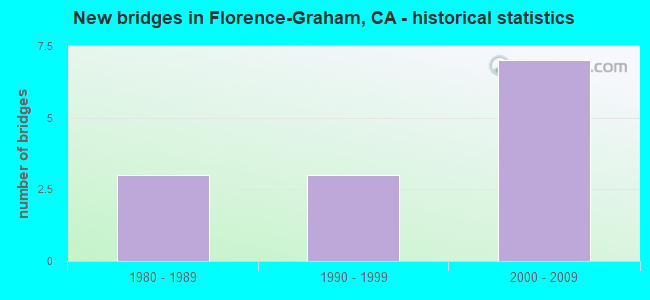
- New bridges - historical statistics
- 31980-1989
- 31990-1999
- 72000-2009


- Bridge Condition - Deck
- 14.3%Good
- 57.1%Satisfactory
- 28.6%Fair

- Bridge Condition - Superstructure
- 85.7%Very good
- 14.3%Good
Find on map >> Show street view
Structure Number: 53C2128, Location: 0.2MI N/O NADEAU ST (Lat: 33.970628, Lng: -118.233806), Route carried "on" structure: County highway , Year Built: 2000, Status: Open, Structure Length: 1.79m (5.87ft), Average Daily Traffic: 505 (year 2012), Average Future Daily Traffic: 556 (year 2040), Design Load: HS 25 or greater, Features Intersected: ACTA, Facility Carried by Structure: METRO CMMERCIAL DW
Minimum Vertical Clearance: 30.47m (99.97ft), Kilometerpoint: 0.000, Lanes on structure: 2, Owner: County Highway Agency, Approaching Roadway Width: 13.4m (44.0ft), Material/Design: Prestressed concrete, Design/Construction: Tee Beam, Number Of Spans In Main Unit: 1, Length of Maximum Span: 15.6m (51.2ft), Curb-To-Curb Width: 13.4m (44.0ft), Out-to-Out Width: 14.7m (48.2ft)
Condition: Deck: Satisfactory, Superstructure: Very good, Substructure: Good, Operating Rating: 68.0 metric tons, Method Used To Determine Operating Rating: Load Factor (LF), Inventory Rating: 39.9 metric tons, Method Used To Determine Inventory Rating: Load Factor (LF), Structural Evaluation: Better than present minimum criteria, Deck Geometry: Superior to present desirable criteria, Underclear: Meets minimum limits, Approach Roadway Alignment: Meets minimum limits, Designated Inspection Frequency: Every 48 months, Inspection Date: December 2020, Deck Structure Type: Concrete Cast-file-Place
Find on map >> Show street view
Structure Number: 53C2129, Location: 40FT E/O ALAMEDA ST (Lat: 33.967331, Lng: -118.233072), Route carried "on" structure: County highway L644, Year Built: 2000, Status: Open, Structure Length: 1.79m (5.87ft), Average Daily Traffic: 15,014 (year 2012), Truck Traffic: 24%, Average Future Daily Traffic: 18,017 (year 2040), Design Load: HS 25 or greater, Features Intersected: ACTA, Facility Carried by Structure: NADEAU ST
Minimum Vertical Clearance: 30.47m (99.97ft), Kilometerpoint: 0.000, Lanes on structure: 5, Owner: County Highway Agency, Approaching Roadway Width: 18.5m (60.7ft), Material/Design: Prestressed concrete, Design/Construction: Tee Beam, Number Of Spans In Main Unit: 1, Length of Maximum Span: 15.6m (51.2ft), Curb or Sidewalk Widths: Left: 7.5m (24.6ft), Right: 5.2m (17.1ft), Curb-To-Curb Width: 19.7m (64.6ft), Out-to-Out Width: 31.6m (103.7ft)
Condition: Deck: Satisfactory, Superstructure: Very good, Substructure: Good, Operating Rating: 69.3 metric tons, Method Used To Determine Operating Rating: Load Factor (LF), Inventory Rating: 39.9 metric tons, Method Used To Determine Inventory Rating: Load Factor (LF), Structural Evaluation: Better than present minimum criteria, Deck Geometry: Meets minimum limits, Underclear: Meets minimum limits, Approach Roadway Alignment: Equal to present desirable criteria, Designated Inspection Frequency: Every 24 months, Inspection Date: December 2020, Deck Structure Type: Concrete Cast-file-Place
Find on map >> Show street view
Structure Number: 53C2131, Location: 400FT N/O FIRESTONE BLVD (Lat: 33.958978, Lng: -118.231242), Route carried "on" structure: County highway , Year Built: 2000, Status: Open, Structure Length: 1.79m (5.87ft), Average Daily Traffic: 306 (year 2012), Truck Traffic: 24%, Average Future Daily Traffic: 306 (year 2040), Design Load: HS 25 or greater, Features Intersected: ACTA, Facility Carried by Structure: HON ENTRANCE
Minimum Vertical Clearance: 30.47m (99.97ft), Kilometerpoint: 0.000, Lanes on structure: 2, Owner: County Highway Agency, Approaching Roadway Width: 13.7m (44.9ft), Material/Design: Prestressed concrete, Design/Construction: Tee Beam, Number Of Spans In Main Unit: 1, Length of Maximum Span: 15.6m (51.2ft), Curb-To-Curb Width: 13.7m (44.9ft), Out-to-Out Width: 14.7m (48.2ft)
Condition: Deck: Good, Superstructure: Very good, Substructure: Good, Operating Rating: 69.7 metric tons, Method Used To Determine Operating Rating: Load Factor (LF), Inventory Rating: 41.8 metric tons, Method Used To Determine Inventory Rating: Load Factor (LF), Structural Evaluation: Better than present minimum criteria, Deck Geometry: Superior to present desirable criteria, Underclear: Meets minimum limits, Approach Roadway Alignment: Meets minimum limits, Designated Inspection Frequency: Every 24 months, Inspection Date: December 2020, Deck Structure Type: Concrete Cast-file-Place
Find on map >> Show street view
Structure Number: 53C2132, Location: 40FT E/O ALAMEDA ST (Lat: 33.957542, Lng: -118.230917), Route carried "on" structure: County highway L164, Year Built: 2000, Status: Open, Structure Length: 1.79m (5.87ft), Average Daily Traffic: 27,945 (year 2012), Truck Traffic: 24%, Average Future Daily Traffic: 33,534 (year 2040), Design Load: HS 25 or greater, Features Intersected: ACTA, Facility Carried by Structure: FIRESTONE BLVD
Minimum Vertical Clearance: 30.47m (99.97ft), Kilometerpoint: 0.000, Lanes on structure: 5, Owner: County Highway Agency, Approaching Roadway Width: 26.3m (86.3ft), Material/Design: Prestressed concrete, Design/Construction: Tee Beam, Number Of Spans In Main Unit: 1, Length of Maximum Span: 15.6m (51.2ft), Curb or Sidewalk Widths: Left: 12.4m (40.7ft), Right: 6.4m (21.0ft), Curb-To-Curb Width: 26.3m (86.3ft), Out-to-Out Width: 44.1m (144.7ft)
Condition: Deck: Satisfactory, Superstructure: Very good, Substructure: Good, Operating Rating: 68.7 metric tons, Method Used To Determine Operating Rating: Load Factor (LF), Inventory Rating: 41.1 metric tons, Method Used To Determine Inventory Rating: Load Factor (LF), Structural Evaluation: Better than present minimum criteria, Deck Geometry: Superior to present desirable criteria, Underclear: Meets minimum limits, Approach Roadway Alignment: Better than present minimum criteria, Designated Inspection Frequency: Every 24 months, Inspection Date: December 2020, Deck Structure Type: Concrete Cast-file-Place
Find on map >> Show street view
Structure Number: 53C2133, Location: 50FT E/O ALAMEDA ST (Lat: 33.953147, Lng: -118.229956), Route carried "on" structure: City street , Year Built: 2000, Status: Open, Structure Length: 1.79m (5.87ft), Average Daily Traffic: 11,400 (year 2012), Truck Traffic: 24%, Average Future Daily Traffic: 13,100 (year 2041), Design Load: HS 25 or greater, Features Intersected: ACTA, Facility Carried by Structure: 92ND ST
Minimum Vertical Clearance: 30.47m (99.97ft), Kilometerpoint: 0.000, Lanes on structure: 5, Owner: County Highway Agency, Approaching Roadway Width: 13.7m (44.9ft), Material/Design: Prestressed concrete, Design/Construction: Tee Beam, Number Of Spans In Main Unit: 1, Length of Maximum Span: 15.6m (51.2ft), Curb or Sidewalk Widths: Left: 3.9m (12.8ft), Right: 6.4m (21.0ft), Curb-To-Curb Width: 18.4m (60.4ft), Out-to-Out Width: 29.2m (95.8ft)
Condition: Deck: Fair, Superstructure: Good, Substructure: Good, Operating Rating: 69.3 metric tons, Method Used To Determine Operating Rating: Load Factor (LF), Inventory Rating: 39.9 metric tons, Method Used To Determine Inventory Rating: Load Factor (LF), Structural Evaluation: Better than present minimum criteria, Deck Geometry: High priority of replacement, Approach Roadway Alignment: Equal to present desirable criteria, Designated Inspection Frequency: Every 24 months, Inspection Date: Febuary 2021, Deck Structure Type: Concrete Cast-file-Place
Find on map >> Show street view
Structure Number: 53C2134, Location: 50FT E/O ALAMEDA ST (Lat: 33.946447, Lng: -118.228486), Route carried "on" structure: County highway , Year Built: 2000, Status: Open, Structure Length: 1.79m (5.87ft), Average Daily Traffic: 15,758 (year 2012), Truck Traffic: 24%, Average Future Daily Traffic: 18,910 (year 2039), Design Load: HS 25 or greater, Features Intersected: ACTA, Facility Carried by Structure: TWEEDY BLVD
Minimum Vertical Clearance: 30.47m (99.97ft), Kilometerpoint: 0.000, Lanes on structure: 4, Owner: County Highway Agency, Approaching Roadway Width: 17.1m (56.1ft), Material/Design: Prestressed concrete, Design/Construction: Tee Beam, Number Of Spans In Main Unit: 1, Length of Maximum Span: 15.6m (51.2ft), Curb or Sidewalk Widths: Left: 6.5m (21.3ft), Right: 5.5m (18.0ft), Curb-To-Curb Width: 19.7m (64.6ft), Out-to-Out Width: 31.7m (104.0ft)
Condition: Deck: Fair, Superstructure: Very good, Substructure: Good, Operating Rating: 69.3 metric tons, Method Used To Determine Operating Rating: Load Factor (LF), Inventory Rating: 39.9 metric tons, Method Used To Determine Inventory Rating: Load Factor (LF), Structural Evaluation: Better than present minimum criteria, Deck Geometry: Better than present minimum criteria, Underclear: Meets minimum limits, Approach Roadway Alignment: Meets minimum limits, Designated Inspection Frequency: Every 24 months, Inspection Date: April 2020, Deck Structure Type: Concrete Cast-file-Place
Find on map >> Show street view
Structure Number: 53C2229, Location: 50FT E/O ALAMEDA ST (Lat: 33.972881, Lng: -118.234283), Route carried "on" structure: County highway , Year Built: 2007, Status: Open, Structure Length: 2.05m (6.73ft), Average Daily Traffic: 909 (year 2012), Truck Traffic: 1%, Average Future Daily Traffic: 1,000 (year 2040), Design Load: HS 20, Features Intersected: ACTA, Facility Carried by Structure: 74TH ST
Minimum Vertical Clearance: 30.47m (99.97ft), Kilometerpoint: 0.000, Lanes on structure: 3, Owner: County Highway Agency, Approaching Roadway Width: 12.2m (40.0ft), Material/Design: Prestressed concrete, Design/Construction: Stringer/Multi-beam, Number Of Spans In Main Unit: 1, Length of Maximum Span: 15.6m (51.2ft), Curb or Sidewalk Widths: Left: 5.1m (16.7ft), Right: 3.4m (11.2ft), Curb-To-Curb Width: 12.2m (40.0ft), Out-to-Out Width: 19.8m (65.0ft)
Condition: Deck: Satisfactory, Superstructure: Very good, Substructure: Good, Operating Rating: 68.7 metric tons, Method Used To Determine Operating Rating: Load Factor (LF), Inventory Rating: 41.1 metric tons, Method Used To Determine Inventory Rating: Load Factor (LF), Structural Evaluation: Better than present minimum criteria, Deck Geometry: Meets minimum limits, Underclear: Meets minimum limits, Approach Roadway Alignment: Meets minimum limits, Designated Inspection Frequency: Every 48 months, Inspection Date: December 2020, Deck Structure Type: Concrete Cast-file-Place
Find on map >> Show street view
Structure Number: 53C1924L, Location: 0.3MI W/O ALAMEDA (Lat: 33.989167, Lng: -118.243425), Route carried "under" structure: County highway L125, Year Built: 1990, Structure Length: 0. m, Average Daily Traffic: 32,095 (year 2012), Truck Traffic: 10%, Features Intersected: SLAUSON AVE, Facility Carried by Structure: LA MTR BLUE LN S
Minimum Vertical Clearance: 7.47m (24.51ft), Kilometerpoint: 0.000, Lanes under structure: 4, Material/Design: Concrete, Design/Construction: Box Beam or Girders - Multiple, Length of Maximum Span: 43.0m (141.1ft)
Find on map >> Show street view
Structure Number: 53C1924R, Location: 0.3MI W/O ALAMEDA (Lat: 33.989164, Lng: -118.243331), Route carried "under" structure: County highway L125, Year Built: 1990, Structure Length: 0. m, Average Daily Traffic: 32,095 (year 2012), Truck Traffic: 10%, Features Intersected: SLAUSON AVE, Facility Carried by Structure: LA MTR BLUE LN N
Minimum Vertical Clearance: 7.47m (24.51ft), Kilometerpoint: 0.000, Lanes under structure: 4, Material/Design: Concrete, Design/Construction: Box Beam or Girders - Multiple, Length of Maximum Span: 43.0m (141.1ft)
Find on map >> Show street view
Structure Number: 53C1929, Location: 0.3MI E/O COMPTON BLVD (Lat: 33.985428, Lng: -118.243267), Route carried "under" structure: County highway L124, Year Built: 1990, Structure Length: 0. m, Average Daily Traffic: 3,768 (year 2012), Truck Traffic: 1%, Features Intersected: 60TH ST, Facility Carried by Structure: LA METRO BLUE LN S
Minimum Vertical Clearance: 8.10m (26.57ft), Kilometerpoint: 0.000, Lanes under structure: 2, Material/Design: Concrete, Design/Construction: Box Beam or Girders - Multiple, Length of Maximum Span: 41.5m (136.2ft)
Find on map >> Show street view
Structure Number: 53C1979, Location: AT GRAHAM AVE (Lat: 33.960011, Lng: -118.243317), Route carried "under" structure: County highway , Year Built: 1987, Structure Length: 0. m, Average Daily Traffic: 35,225 (year 2012), Truck Traffic: 6%, Features Intersected: FIRESTONE BLVD, Facility Carried by Structure: SP/UP RR
Minimum Vertical Clearance: 4.50m (14.76ft), Kilometerpoint: 0.000, Lanes under structure: 7, Material/Design: Prestressed concrete, Design/Construction: Box Beam or Girders - Multiple, Length of Maximum Span: 30.5m (100.1ft)
Find on map >> Show street view
Structure Number: 53C198, Location: AT GRAHAM AVE (Lat: 33.960017, Lng: -118.243225), Route carried "under" structure: County highway , Year Built: 1987, Structure Length: 0. m, Average Daily Traffic: 35,225 (year 2012), Truck Traffic: 6%, Features Intersected: FIRESTONE BLVD, Facility Carried by Structure: BLUE LINE LRT S
Minimum Vertical Clearance: 4.50m (14.76ft), Kilometerpoint: 0.000, Lanes under structure: 7, Material/Design: Prestressed concrete, Design/Construction: Stringer/Multi-beam, Length of Maximum Span: 30.4m (99.7ft)
Find on map >> Show street view
Structure Number: 53C1981, Location: AT GRAHAM AVE (Lat: 33.960011, Lng: -118.243131), Route carried "under" structure: County highway , Year Built: 1987, Structure Length: 0. m, Average Daily Traffic: 35,225 (year 2012), Truck Traffic: 6%, Features Intersected: FIRESTONE BLVD, Facility Carried by Structure: BLUE LINE LRT N
Minimum Vertical Clearance: 4.70m (15.42ft), Kilometerpoint: 0.000, Lanes under structure: 7, Material/Design: Prestressed concrete, Design/Construction: Stringer/Multi-beam, Length of Maximum Span: 32.3m (106.0ft)