Bridge Statistics for Fishkill, New York (NY)
Condition, Traffic, Stress, Structural Evaluation, Project Costs
- National Bridge Inventory (NBI) Statistics
- 16Number of bridges
- 174ft / 53.0mTotal length
- $53,106,000Total costs
- 388,904Total average daily traffic
- 36,808Total average daily truck traffic
- National Bridge Inventory (NBI) Registered Bridges for Fishkill
- No street view available for this location
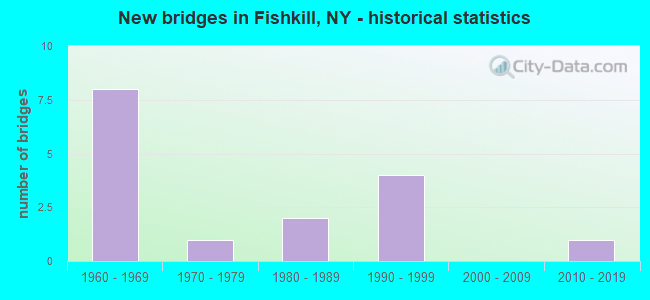
- New bridges - historical statistics
- 81960-1969
- 11970-1979
- 21980-1989
- 41990-1999
- 12010-2019

- Reconstructed bridges - Historical Statistics
- 42000-2009
- 22010-2019


- Bridge Condition - Deck
- 33.3%Excellent
- 22.2%Good
- 22.2%Satisfactory
- 22.2%Fair

- Bridge Condition - Superstructure
- 11.1%Excellent
- 66.7%Satisfactory
- 11.1%Fair
- 11.1%Poor

- Bridge Condition - Substructure
- 11.1%Very good
- 33.3%Good
- 22.2%Satisfactory
- 33.3%Fair

- Bridge Condition - Channel
- 14.3%Good
- 71.4%Satisfactory
- 14.3%Fair

- Bridge Condition - Culverts
- 66.7%Good
- 33.3%Fair
Find on map >> Show street view
Structure Number: 1005201, Location: JCT RTS I-84 & 9 (Lat: 41.524053, Lng: -73.890347), Route carried "on" structure: Interstate 84, Year Built: 1998, Status: Open, Structure Length: 4.91m (16.11ft), Average Daily Traffic: 25,349 (year 1999), Truck Traffic: 15%, Design Load: HS 25 or greater, Features Intersected: 9 9 82051026 NB, RTE 9
Minimum Vertical Clearance: 30+ m (98+ ft), Kilometerpoint: 9.606, Lanes on structure: 4, Lanes under structure: 8, Base Highway Network: Yes, Owner: State Highway Agency, Approaching Roadway Width: 19.5m (64.0ft), Material/Design: Prestressed concrete, Design/Construction: Box Beam or Girders - Multiple, Number Of Spans In Main Unit: 2, Length of Maximum Span: 23.7m (77.8ft), Curb-To-Curb Width: 19.5m (64.0ft), Out-to-Out Width: 20.5m (67.3ft)
Condition: Deck: Good, Superstructure: Satisfactory, Substructure: Good, Inventory Rating: 68.9 metric tons, Method Used To Determine Inventory Rating: Load Factor (LF), Structural Evaluation: Equal to present minimum criteria, Deck Geometry: Somewhat better than minimum adequacy, Underclear: High priority of corrective action, Approach Roadway Alignment: Equal to present desirable criteria, Length Of Structure Improvement: 4.90m (16.08ft), Designated Inspection Frequency: Every 24 months, Inspection Date: July 2020, Bridge Improvement Cost: $3,199,000, Roadway Improvement Cost: $1,873,000, Total Project Cost: $5,072,000 ( Estimate for 2021), Deck Structure Type: Concrete Cast-file-Place, Wearing Surface/Protective System: Wearing Surface: Integral Concrete, Deck Protection: Epoxy Coated Reinforcing
Find on map >> Show street view
Structure Number: 1005202, Location: JCT RTS I-84 & 9 (Lat: 41.523725, Lng: -73.890203), Route carried "on" structure: Interstate 84, Year Built: 1998, Status: Open, Structure Length: 4.91m (16.11ft), Average Daily Traffic: 22,159 (year 2019), Truck Traffic: 16%, Average Future Daily Traffic: 37,524 (year 2040), Design Load: HS 25 or greater, Features Intersected: 9 9 82051027 NB, RTE 9
Minimum Vertical Clearance: 30+ m (98+ ft), Kilometerpoint: 9.574, Lanes on structure: 4, Lanes under structure: 8, Base Highway Network: Yes, Owner: State Highway Agency, Approaching Roadway Width: 19.5m (64.0ft), Material/Design: Prestressed concrete, Design/Construction: Box Beam or Girders - Multiple, Number Of Spans In Main Unit: 2, Length of Maximum Span: 23.7m (77.8ft), Curb-To-Curb Width: 19.5m (64.0ft), Out-to-Out Width: 20.5m (67.3ft)
Condition: Deck: Good, Superstructure: Satisfactory, Substructure: Good, Inventory Rating: 68.9 metric tons, Method Used To Determine Inventory Rating: Load Factor (LF), Structural Evaluation: Equal to present minimum criteria, Deck Geometry: Somewhat better than minimum adequacy, Underclear: Meets minimum limits, Approach Roadway Alignment: Equal to present desirable criteria, Length Of Structure Improvement: 4.90m (16.08ft), Designated Inspection Frequency: Every 24 months, Inspection Date: July 2020, Bridge Improvement Cost: $3,196,000, Roadway Improvement Cost: $1,872,000, Total Project Cost: $5,068,000 ( Estimate for 2021), Deck Structure Type: Concrete Cast-file-Place, Wearing Surface/Protective System: Wearing Surface: Integral Concrete, Deck Protection: Epoxy Coated Reinforcing
Find on map >> Show street view
Structure Number: 1005211, Location: 0.6 MI N JCT RTS I84 & 9 (Lat: 41.531994, Lng: -73.895378), Route carried "on" structure: US 9, Year Built: 1980, Year Reconstructed: 2019, Status: Open, Structure Length: 5.12m (16.80ft), Average Daily Traffic: 16,045 (year 2017), Truck Traffic: 4%, Average Future Daily Traffic: 16,120 (year 2040), Design Load: HS 20, Features Intersected: FISHKILL CREEK
Minimum Vertical Clearance: 30+ m (98+ ft), Kilometerpoint: 5.068, Lanes on structure: 3, Base Highway Network: Yes, Owner: State Highway Agency, Approaching Roadway Width: 13.4m (44.0ft), Skew: 2 degrees, Material/Design: Prestressed concrete, Design/Construction: Box Beam or Girders - Multiple, Number Of Spans In Main Unit: 2, Length of Maximum Span: 24.3m (79.7ft), Curb or Sidewalk Widths: Left: 1.8m (5.9ft), Right: 0.0m, Curb-To-Curb Width: 14.9m (48.9ft), Out-to-Out Width: 17.8m (58.4ft)
Condition: Deck: Excellent, Superstructure: Satisfactory, Substructure: Satisfactory, Channel: Satisfactory, Operating Rating: 45.0 metric tons, Method Used To Determine Operating Rating: Load and Resistance Factor Rating (LRFR) rating reported by rating factor(RF) method using HL-93 loadings, Inventory Rating: 34.7 metric tons, Method Used To Determine Inventory Rating: Load and Resistance Factor Rating (LRFR) rating reported by rating factor(RF) method using HL-93 loadings, Structural Evaluation: Equal to present minimum criteria, Deck Geometry: Equal to present minimum criteria, Waterway Adequacy: Somewhat better than minimum adequacy, Approach Roadway Alignment: Equal to present desirable criteria, Length Of Structure Improvement: 5.12m (16.80ft), Designated Inspection Frequency: Every 24 months, Inspection Date: March 2021, Bridge Improvement Cost: $2,411,000, Roadway Improvement Cost: $1,412,000, Total Project Cost: $3,822,000 ( Estimate for 2021), Deck Structure Type: Concrete Cast-file-Place, Wearing Surface/Protective System: Wearing Surface: Integral Concrete, Deck Protection: Epoxy Coated Reinforcing
Find on map >> Show street view
Structure Number: 1005212, Location: 0.6 MI N JCT RTS I84 & 9 (Lat: 41.532014, Lng: -73.895094), Route carried "on" structure: US 9, Year Built: 1980, Year Reconstructed: 2019, Status: Open, Structure Length: 5.12m (16.80ft), Average Daily Traffic: 16,045 (year 2017), Truck Traffic: 4%, Average Future Daily Traffic: 16,120 (year 2040), Design Load: HS 20, Features Intersected: FISHKILL CREEK
Minimum Vertical Clearance: 30+ m (98+ ft), Kilometerpoint: 5.068, Lanes on structure: 3, Base Highway Network: Yes, Owner: State Highway Agency, Approaching Roadway Width: 13.4m (44.0ft), Skew: 2 degrees, Material/Design: Prestressed concrete, Design/Construction: Box Beam or Girders - Multiple, Number Of Spans In Main Unit: 2, Length of Maximum Span: 24.3m (79.7ft), Curb or Sidewalk Widths: Left: 0.0m, Right: 1.8m (5.9ft), Curb-To-Curb Width: 14.4m (47.2ft), Out-to-Out Width: 17.8m (58.4ft)
Condition: Deck: Excellent, Superstructure: Satisfactory, Substructure: Satisfactory, Channel: Fair, Operating Rating: 46.0 metric tons, Method Used To Determine Operating Rating: Load and Resistance Factor Rating (LRFR) rating reported by rating factor(RF) method using HL-93 loadings, Inventory Rating: 35.6 metric tons, Method Used To Determine Inventory Rating: Load and Resistance Factor Rating (LRFR) rating reported by rating factor(RF) method using HL-93 loadings, Structural Evaluation: Equal to present minimum criteria, Deck Geometry: Somewhat better than minimum adequacy, Waterway Adequacy: Somewhat better than minimum adequacy, Approach Roadway Alignment: Equal to present desirable criteria, Length Of Structure Improvement: 5.12m (16.80ft), Designated Inspection Frequency: Every 24 months, Inspection Date: March 2021, Bridge Improvement Cost: $2,489,000, Roadway Improvement Cost: $1,457,000, Total Project Cost: $3,946,000 ( Estimate for 2021), Deck Structure Type: Concrete Cast-file-Place, Wearing Surface/Protective System: Wearing Surface: Integral Concrete, Deck Protection: Epoxy Coated Reinforcing
Find on map >> Show street view
Structure Number: 1026831, Location: 3.3 MI E JCT RTS I84+9D (Lat: 41.527303, Lng: -73.915986), Route carried "on" structure: Interstate 84, Year Built: 1963, Year Reconstructed: 2006, Status: Open, Structure Length: 5.91m (19.39ft), Average Daily Traffic: 25,349 (year 1999), Truck Traffic: 15%, Design Load: HS 20+Mod, Features Intersected: RTE 52
Minimum Vertical Clearance: 30+ m (98+ ft), Kilometerpoint: 72.083, Lanes on structure: 2, Lanes under structure: 4, Base Highway Network: Yes, Owner: State Highway Agency, Approaching Roadway Width: 10.7m (35.1ft), Skew: 3 degrees, Material/Design: Steel, Design/Construction: Stringer/Multi-beam, Number Of Spans In Main Unit: 3, Length of Maximum Span: 28.0m (91.9ft), Curb-To-Curb Width: 9.0m (29.5ft), Out-to-Out Width: 10.1m (33.1ft)
Condition: Deck: Fair, Superstructure: Satisfactory, Substructure: Fair, Operating Rating: 81.6 metric tons, Method Used To Determine Operating Rating: Load Factor (LF), Inventory Rating: 49.0 metric tons, Method Used To Determine Inventory Rating: Load Factor (LF), Structural Evaluation: Somewhat better than minimum adequacy, Deck Geometry: High priority of replacement, Underclear: Meets minimum limits, Approach Roadway Alignment: Equal to present desirable criteria, Length Of Structure Improvement: 5.91m (19.39ft), Designated Inspection Frequency: Every 24 months, Inspection Date: June 2021, Bridge Improvement Cost: $2,299,000, Roadway Improvement Cost: $1,346,000, Total Project Cost: $3,645,000 ( Estimate for 2021), Deck Structure Type: Concrete Cast-file-Place, Wearing Surface/Protective System: Wearing Surface: Monolithic Concrete
Find on map >> Show street view
Structure Number: 1026832, Location: 3.3 MI E JCT RTS I84+9D (Lat: 41.527211, Lng: -73.916350), Route carried "on" structure: Interstate 84, Year Built: 1963, Year Reconstructed: 2006, Status: Open, Structure Length: 5.91m (19.39ft), Average Daily Traffic: 22,159 (year 2019), Truck Traffic: 15%, Average Future Daily Traffic: 37,524 (year 2040), Design Load: HS 20+Mod, Features Intersected: RTE 52
Minimum Vertical Clearance: 30+ m (98+ ft), Kilometerpoint: 7.224, Lanes on structure: 2, Lanes under structure: 2, Base Highway Network: Yes, Owner: State Highway Agency, Approaching Roadway Width: 10.7m (35.1ft), Skew: 3 degrees, Material/Design: Steel, Design/Construction: Stringer/Multi-beam, Number Of Spans In Main Unit: 3, Length of Maximum Span: 28.0m (91.9ft), Curb-To-Curb Width: 9.0m (29.5ft), Out-to-Out Width: 10.1m (33.1ft)
Condition: Deck: Fair, Superstructure: Satisfactory, Substructure: Fair, Operating Rating: 81.6 metric tons, Method Used To Determine Operating Rating: Load Factor (LF), Inventory Rating: 49.0 metric tons, Method Used To Determine Inventory Rating: Load Factor (LF), Structural Evaluation: Somewhat better than minimum adequacy, Deck Geometry: High priority of replacement, Underclear: Meets minimum limits, Approach Roadway Alignment: Equal to present desirable criteria, Length Of Structure Improvement: 5.91m (19.39ft), Designated Inspection Frequency: Every 24 months, Inspection Date: June 2021, Bridge Improvement Cost: $2,299,000, Roadway Improvement Cost: $1,346,000, Total Project Cost: $3,645,000 ( Estimate for 2021), Deck Structure Type: Concrete Cast-file-Place, Wearing Surface/Protective System: Wearing Surface: Monolithic Concrete
Find on map >> Show street view
Structure Number: 103248, Location: 1.2 MI W JCT I84 & US 9 (Lat: 41.525242, Lng: -73.912308), Route carried "on" structure: Interstate 84, Year Built: 2018, Status: Open, Structure Length: 2.93m (9.61ft), Average Daily Traffic: 44,318 (year 2019), Truck Traffic: 15%, Average Future Daily Traffic: 75,048 (year 2040), Design Load: HL 93, Features Intersected: MNRR Beacon Line
Minimum Vertical Clearance: 32.69m (107.25ft), Kilometerpoint: 7.627, Lanes on structure: 6, Owner: State Highway Agency, Approaching Roadway Width: 28.0m (91.9ft), Skew: 21 degrees, Material/Design: Steel, Design/Construction: Stringer/Multi-beam, Number Of Spans In Main Unit: 1, Length of Maximum Span: 27.4m (89.9ft), Curb-To-Curb Width: 28.0m (91.9ft), Out-to-Out Width: 45.0m (147.6ft)
Condition: Deck: Excellent, Superstructure: Excellent, Substructure: Very good, Operating Rating: 81.6 metric tons, Method Used To Determine Operating Rating: Load Factor (LF), Inventory Rating: 49.0 metric tons, Method Used To Determine Inventory Rating: Load Factor (LF), Structural Evaluation: Equal to present desirable criteria, Deck Geometry: Equal to present minimum criteria, Underclear: High priority of corrective action, Approach Roadway Alignment: Equal to present desirable criteria, Length Of Structure Improvement: 2.92m (9.58ft), Designated Inspection Frequency: Every 24 months, Inspection Date: July 2021, Bridge Improvement Cost: $9,014,000, Roadway Improvement Cost: $5,278,000, Total Project Cost: $14,292,000 ( Estimate for 2021), Deck Structure Type: Concrete Cast-file-Place, Wearing Surface/Protective System: Wearing Surface: Monolithic Concrete, Deck Protection: Other
Find on map >> Show street view
Structure Number: 1032491, Location: 1.0 MI W JCT RTS I84+9 (Lat: 41.523386, Lng: -73.908042), Route carried "on" structure: Interstate 84, Year Built: 1963, Year Reconstructed: 2006, Status: Open, Structure Length: 6.98m (22.90ft), Average Daily Traffic: 25,349 (year 1999), Truck Traffic: 15%, Design Load: HS 20, Features Intersected: FISHKILL CREEK
Minimum Vertical Clearance: 30+ m (98+ ft), Kilometerpoint: 8.045, Lanes on structure: 2, Base Highway Network: Yes, Owner: State Highway Agency, Approaching Roadway Width: 11.0m (36.1ft), Skew: 1 degrees, Material/Design: Steel, Design/Construction: Stringer/Multi-beam, Number Of Spans In Main Unit: 2, Length of Maximum Span: 35.1m (115.2ft), Curb-To-Curb Width: 9.0m (29.5ft), Out-to-Out Width: 10.1m (33.1ft)
Condition: Deck: Satisfactory, Superstructure: Fair, Substructure: Good, Channel: Satisfactory, Operating Rating: 85.3 metric tons, Method Used To Determine Operating Rating: Load Factor (LF), Inventory Rating: 50.8 metric tons, Method Used To Determine Inventory Rating: Load Factor (LF), Structural Evaluation: Somewhat better than minimum adequacy, Deck Geometry: Meets minimum limits, Waterway Adequacy: High priority of corrective action, Approach Roadway Alignment: Equal to present desirable criteria, Length Of Structure Improvement: 6.97m (22.87ft), Designated Inspection Frequency: Every 24 months, Inspection Date: June 2021, Bridge Improvement Cost: $2,821,000, Roadway Improvement Cost: $1,652,000, Total Project Cost: $4,473,000 ( Estimate for 2021), Deck Structure Type: Concrete Cast-file-Place, Wearing Surface/Protective System: Wearing Surface: Integral Concrete
Find on map >> Show street view
Structure Number: 1032492, Location: 1.0 MI W JCT RTS I84+9 (Lat: 41.523200, Lng: -73.908242), Route carried "on" structure: Interstate 84, Year Built: 1963, Year Reconstructed: 2006, Status: Open, Structure Length: 6.98m (22.90ft), Average Daily Traffic: 22,159 (year 2019), Truck Traffic: 15%, Average Future Daily Traffic: 37,524 (year 2040), Design Load: HS 20, Features Intersected: FISHKILL CREEK
Minimum Vertical Clearance: 30+ m (98+ ft), Kilometerpoint: 8.029, Lanes on structure: 2, Base Highway Network: Yes, Owner: State Highway Agency, Approaching Roadway Width: 11.0m (36.1ft), Skew: 1 degrees, Material/Design: Steel, Design/Construction: Stringer/Multi-beam, Number Of Spans In Main Unit: 2, Length of Maximum Span: 35.1m (115.2ft), Curb-To-Curb Width: 9.0m (29.5ft), Out-to-Out Width: 10.1m (33.1ft)
Condition: Deck: Satisfactory, Superstructure: Poor, Substructure: Fair, Channel: Good, Operating Rating: 78.9 metric tons, Method Used To Determine Operating Rating: Load Factor (LF), Inventory Rating: 47.2 metric tons, Method Used To Determine Inventory Rating: Load Factor (LF), Structural Evaluation: Meets minimum limits, Deck Geometry: Meets minimum limits, Waterway Adequacy: Meets minimum limits, Approach Roadway Alignment: Equal to present desirable criteria, Length Of Structure Improvement: 6.97m (22.87ft), Designated Inspection Frequency: Every 24 months, Inspection Date: July 2021, Bridge Improvement Cost: $2,821,000, Roadway Improvement Cost: $1,652,000, Total Project Cost: $4,473,000 ( Estimate for 2021), Deck Structure Type: Concrete Cast-file-Place, Wearing Surface/Protective System: Wearing Surface: Integral Concrete
Find on map >> Show street view
Structure Number: 1032501, Location: 0.5 MI W JCT RTS I84+9 (Lat: 41.522739, Lng: -73.900017), Route carried "on" structure: Interstate 84, Year Built: 1963, Status: Open, Structure Length: 1.71m (5.61ft), Average Daily Traffic: 25,349 (year 1999), Truck Traffic: 15%, Design Load: HS 20, Features Intersected: CLOVE CREEK
Minimum Vertical Clearance: 30+ m (98+ ft), Kilometerpoint: 7.176, Lanes on structure: 3, Base Highway Network: Yes, Owner: State Highway Agency, Approaching Roadway Width: 14.6m (47.9ft), Material/Design: Concrete continuous, Design/Construction: Culvert, Number Of Spans In Main Unit: 3, Length of Maximum Span: 5.1m (16.7ft), Curb-To-Curb Width: 16.7m (54.8ft), Out-to-Out Width: 17.3m (56.8ft)
Condition: Channel: Satisfactory, Culverts: Good, Operating Rating: 42.6 metric tons, Method Used To Determine Operating Rating: Allowable Stress (AS), Inventory Rating: 28.1 metric tons, Method Used To Determine Inventory Rating: Allowable Stress (AS), Structural Evaluation: Better than present minimum criteria, Deck Geometry: Equal to present minimum criteria, Waterway Adequacy: Equal to present minimum criteria, Approach Roadway Alignment: Equal to present desirable criteria, Length Of Structure Improvement: 1.70m (5.58ft), Designated Inspection Frequency: Every 24 months, Inspection Date: April 2021, Bridge Improvement Cost: $1,666,000, Roadway Improvement Cost: $976,000, Total Project Cost: $2,642,000 ( Estimate for 2021)
Find on map >> Show street view
Structure Number: 1032502, Location: 0.5 MI W JCT RTS I84+9 (Lat: 41.522414, Lng: -73.899950), Route carried "on" structure: Interstate 84, Year Built: 1963, Status: Open, Structure Length: 1.71m (5.61ft), Average Daily Traffic: 22,159 (year 2019), Truck Traffic: 15%, Average Future Daily Traffic: 37,524 (year 2040), Design Load: HS 20, Features Intersected: CLOVE CREEK
Minimum Vertical Clearance: 30+ m (98+ ft), Kilometerpoint: 8.753, Lanes on structure: 3, Base Highway Network: Yes, Owner: State Highway Agency, Approaching Roadway Width: 15.8m (51.8ft), Material/Design: Concrete continuous, Design/Construction: Culvert, Number Of Spans In Main Unit: 3, Length of Maximum Span: 5.1m (16.7ft), Curb-To-Curb Width: 16.7m (54.8ft), Out-to-Out Width: 17.3m (56.8ft)
Condition: Channel: Satisfactory, Culverts: Good, Operating Rating: 42.6 metric tons, Method Used To Determine Operating Rating: Allowable Stress (AS), Inventory Rating: 28.1 metric tons, Method Used To Determine Inventory Rating: Allowable Stress (AS), Structural Evaluation: Better than present minimum criteria, Deck Geometry: Equal to present minimum criteria, Waterway Adequacy: Meets minimum limits, Approach Roadway Alignment: Equal to present desirable criteria, Length Of Structure Improvement: 1.70m (5.58ft), Designated Inspection Frequency: Every 24 months, Inspection Date: April 2021, Bridge Improvement Cost: $1,014,000, Roadway Improvement Cost: $594,000, Total Project Cost: $1,608,000 ( Estimate for 2021)
Find on map >> Show street view
Structure Number: 335842, Location: 0.5 MI.W.OF FISHKILL (Lat: 41.535917, Lng: -73.910083), Route carried "on" structure: County highway , Year Built: 1973, Status: Open, Structure Length: 0.82m (2.69ft), Average Daily Traffic: 7,876 (year 2020), Truck Traffic: 2%, Average Future Daily Traffic: 9,744 (year 2040), Features Intersected: FORGE BROOK, Facility Carried by Structure: COUNTY ROAD 34
Minimum Vertical Clearance: 30+ m (98+ ft), Kilometerpoint: 4.006, Lanes on structure: 2, Owner: County Highway Agency, Approaching Roadway Width: 7.0m (23.0ft), Skew: 1 degrees, Material/Design: Steel, Design/Construction: Culvert, Number Of Spans In Main Unit: 2, Length of Maximum Span: 3.0m (9.8ft)
Condition: Channel: Satisfactory, Culverts: Fair, Operating Rating: 73.8 metric tons, Method Used To Determine Operating Rating: Field evaluation and documented engineering judgment, Inventory Rating: 19.6 metric tons, Method Used To Determine Inventory Rating: Field evaluation and documented engineering judgment, Structural Evaluation: Meets minimum limits, Waterway Adequacy: Somewhat better than minimum adequacy, Approach Roadway Alignment: Better than present minimum criteria, Length Of Structure Improvement: 0.82m (2.69ft), Designated Inspection Frequency: Every 24 months, Inspection Date: October 2021, Bridge Improvement Cost: $265,000, Roadway Improvement Cost: $155,000, Total Project Cost: $420,000 ( Estimate for 2021)
Find on map >> Show street view
Structure Number: 1005201, Location: JCT RTS I-84 & 9 (Lat: 41.524053, Lng: -73.890347), Route carried "under" structure: US 9, Year Built: 1998, Structure Length: 0. m, Average Daily Traffic: 19,394 (year 1999), Features Intersected: 9 9 82051026 NB, RTE 9, Facility Carried by Structure: RTE I84
Minimum Vertical Clearance: 4.92m (16.14ft), Kilometerpoint: 3.926, Lanes on structure: 4, Lanes under structure: 4, Material/Design: Prestressed concrete, Design/Construction: Box Beam or Girders - Multiple, Length of Maximum Span: 23.7m (77.8ft)
Find on map >> Show street view
Structure Number: 1005202, Location: JCT RTS I-84 & 9 (Lat: 41.523725, Lng: -73.890203), Route carried "under" structure: US 9, Year Built: 1998, Structure Length: 0. m, Average Daily Traffic: 19,394 (year 1999), Features Intersected: 9 9 82051027 NB, RTE 9, Facility Carried by Structure: RTE I84
Minimum Vertical Clearance: 4.92m (16.14ft), Kilometerpoint: 3.926, Lanes on structure: 4, Lanes under structure: 4, Material/Design: Prestressed concrete, Design/Construction: Box Beam or Girders - Multiple, Length of Maximum Span: 23.7m (77.8ft)
Find on map >> Show street view
Structure Number: 1026831, Location: 3.3 MI E JCT RTS I84+9D (Lat: 41.527303, Lng: -73.915986), Route carried "under" structure: State highway 52, Year Built: 1963, Structure Length: 0. m, Average Daily Traffic: 37,900 (year 1984), Features Intersected: RTE 52, Facility Carried by Structure: RTE I84
Minimum Vertical Clearance: 4.95m (16.24ft), Kilometerpoint: 138.374, Lanes on structure: 2, Lanes under structure: 4, Material/Design: Steel, Design/Construction: Stringer/Multi-beam, Length of Maximum Span: 28.0m (91.9ft)
Find on map >> Show street view
Structure Number: 1026832, Location: 3.3 MI E JCT RTS I84+9D (Lat: 41.527211, Lng: -73.916350), Route carried "under" structure: State highway 52, Year Built: 1963, Structure Length: 0. m, Average Daily Traffic: 37,900 (year 1984), Features Intersected: RTE 52, Facility Carried by Structure: RTE I84
Minimum Vertical Clearance: 4.95m (16.24ft), Kilometerpoint: 138.374, Lanes on structure: 2, Lanes under structure: 2, Material/Design: Steel, Design/Construction: Stringer/Multi-beam, Length of Maximum Span: 28.0m (91.9ft)