Bridge Statistics for Fair Lakes, Virginia (VA)
Condition, Traffic, Stress, Structural Evaluation, Project Costs
- National Bridge Inventory (NBI) Statistics
- 31Number of bridges
- 154ft / 47.4mTotal length
- $1,978,000Total costs
- 866,048Total average daily traffic
- 12,004Total average daily truck traffic
- National Bridge Inventory (NBI) Registered Bridges for Fair Lakes
- No street view available for this location
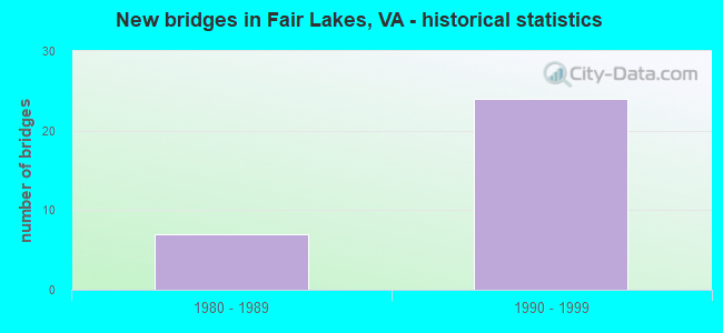
- New bridges - historical statistics
- 71980-1989
- 241990-1999


- Bridge Condition - Superstructure
- 75.0%Good
- 25.0%Satisfactory

- Bridge Condition - Substructure
- 62.5%Good
- 37.5%Satisfactory
Find on map >> Show street view
Structure Number: 6376, Location: 02.54FR28/02.16TO50 (Lat: 38.854553, Lng: -77.388997), Route carried "on" structure: Interstate 66, Year Built: 1986, Year Reconstructed: 2021, Status: Open, Structure Length: 5.12m (16.80ft), Average Daily Traffic: 61,832 (year 2020), Truck Traffic: 3%, Average Future Daily Traffic: 86,565 (year 2040), Design Load: HS 20, Features Intersected: FAIRFAX CO. PKY. RT 286
Minimum Vertical Clearance: 30+ m (98+ ft), Kilometerpoint: 89.863, Lanes on structure: 4, Lanes under structure: 8, Base Highway Network: Yes, Owner: State Highway Agency, Approaching Roadway Width: 25.6m (84.0ft), Material/Design: Steel continuous, Design/Construction: Stringer/Multi-beam, Number Of Spans In Main Unit: 2, Length of Maximum Span: 25.6m (84.0ft), Curb-To-Curb Width: 22.6m (74.1ft), Out-to-Out Width: 23.5m (77.1ft)
Condition: Deck: Good, Superstructure: Satisfactory, Substructure: Satisfactory, Operating Rating: 80.7 metric tons, Method Used To Determine Operating Rating: Load Factor (LF), Inventory Rating: 61.7 metric tons, Method Used To Determine Inventory Rating: Load Factor (LF), Structural Evaluation: Equal to present minimum criteria, Deck Geometry: Superior to present desirable criteria, Underclear: Equal to present minimum criteria, Approach Roadway Alignment: Equal to present desirable criteria, Length Of Structure Improvement: 5.94m (19.49ft), Designated Inspection Frequency: Every 24 months, Inspection Date: September 2021, Bridge Improvement Cost: $79,000, Roadway Improvement Cost: $105,000, Total Project Cost: $250,000 ( Estimate for 2014), Deck Structure Type: Concrete Cast-file-Place, Wearing Surface/Protective System: Deck Protection: Epoxy Coated Reinforcing
Find on map >> Show street view
Structure Number: 6378, Location: 2.54mi.Fr 28/2.16mi.To 50 (Lat: 38.854264, Lng: -77.388872), Route carried "on" structure: Interstate 66, Year Built: 1986, Status: Open, Structure Length: 5.12m (16.80ft), Average Daily Traffic: 48,739 (year 2020), Truck Traffic: 3%, Average Future Daily Traffic: 68,235 (year 2040), Design Load: HS 20, Features Intersected: FAIRFAX CO. PKY. RT 286
Minimum Vertical Clearance: 30+ m (98+ ft), Kilometerpoint: 89.316, Lanes on structure: 3, Lanes under structure: 8, Base Highway Network: Yes, Owner: State Highway Agency, Approaching Roadway Width: 22.6m (74.1ft), Material/Design: Steel continuous, Design/Construction: Stringer/Multi-beam, Number Of Spans In Main Unit: 2, Length of Maximum Span: 25.6m (84.0ft), Curb or Sidewalk Widths: Left: 0.2m (0.7ft), Right: 0.2m (0.7ft), Curb-To-Curb Width: 22.6m (74.1ft), Out-to-Out Width: 23.6m (77.4ft)
Condition: Deck: Good, Superstructure: Satisfactory, Substructure: Satisfactory, Operating Rating: 71.4 metric tons, Method Used To Determine Operating Rating: Load and Resistance Factor (LRFR), Inventory Rating: 55.1 metric tons, Method Used To Determine Inventory Rating: Load and Resistance Factor (LRFR), Structural Evaluation: Equal to present minimum criteria, Deck Geometry: Superior to present desirable criteria, Underclear: High priority of corrective action, Approach Roadway Alignment: Equal to present desirable criteria, Length Of Structure Improvement: 5.12m (16.80ft), Designated Inspection Frequency: Every 24 months, Inspection Date: September 2021, Bridge Improvement Cost: $100,000, Roadway Improvement Cost: $200,000, Total Project Cost: $400,000 ( Estimate for 2014), Deck Structure Type: Concrete Cast-file-Place, Wearing Surface/Protective System: Deck Protection: Epoxy Coated Reinforcing
Find on map >> Show street view
Structure Number: 71, Location: 00.20FR7886 / 00.08TO29 (Lat: 38.840019, Lng: -77.393075), Route carried "on" structure: County highway 7885, Year Built: 1988, Status: Open, Structure Length: 1.16m (3.81ft), Average Daily Traffic: 3,976 (year 2001), Average Future Daily Traffic: 4,751 (year 2040), Design Load: HS 20, Features Intersected: WILLOW SPRING BRANCH, Facility Carried by Structure: HAMPTON FOREST WAY
Minimum Vertical Clearance: 30+ m (98+ ft), Kilometerpoint: 0.048, Lanes on structure: 3, Owner: State Highway Agency, Approaching Roadway Width: 11.6m (38.1ft), Skew: 3 degrees, Material/Design: Concrete, Design/Construction: Culvert, Number Of Spans In Main Unit: 3, Length of Maximum Span: 3.7m (12.1ft), Curb or Sidewalk Widths: Left: 1.2m (3.9ft), Right: 0.0m
Condition: Channel: Fair, Culverts: Good, Operating Rating: 68.0 metric tons, Method Used To Determine Operating Rating: Load Factor (LF), Inventory Rating: 40.8 metric tons, Method Used To Determine Inventory Rating: Load Factor (LF), Structural Evaluation: Better than present minimum criteria, Waterway Adequacy: Better than present minimum criteria, Approach Roadway Alignment: Equal to present minimum criteria, Designated Inspection Frequency: Every 24 months, Inspection Date: Febuary 2021
Find on map >> Show street view
Structure Number: 24089, Location: 02.54FR.28/02.16TO50 (Lat: 38.853861, Lng: -77.388700), Route carried "on" structure: Ramp Interstate 66, Year Built: 1994, Status: Open, Structure Length: 5.94m (19.49ft), Average Daily Traffic: 6,000 (year 2002), Truck Traffic: 5%, Average Future Daily Traffic: 11,250 (year 2034), Design Load: HS 20, Features Intersected: FAIRFAX COUNTY PARKWAY
Minimum Vertical Clearance: 30+ m (98+ ft), Kilometerpoint: 0.756, Lanes on structure: 2, Lanes under structure: 8, Base Highway Network: Yes, Owner: State Highway Agency, Approaching Roadway Width: 13.1m (43.0ft), Material/Design: Steel continuous, Design/Construction: Stringer/Multi-beam, Number Of Spans In Main Unit: 2, Length of Maximum Span: 31.1m (102.0ft), Curb-To-Curb Width: 12.2m (40.0ft), Out-to-Out Width: 13.2m (43.3ft)
Condition: Deck: Good, Superstructure: Good, Substructure: Satisfactory, Operating Rating: 71.7 metric tons, Method Used To Determine Operating Rating: Load and Resistance Factor (LRFR), Inventory Rating: 55.3 metric tons, Method Used To Determine Inventory Rating: Load and Resistance Factor (LRFR), Structural Evaluation: Equal to present minimum criteria, Deck Geometry: Superior to present desirable criteria, Underclear: Equal to present minimum criteria, Approach Roadway Alignment: Equal to present desirable criteria, Length Of Structure Improvement: 5.94m (19.49ft), Designated Inspection Frequency: Every 24 months, Inspection Date: July 2020, Bridge Improvement Cost: $100,000, Roadway Improvement Cost: $100,000, Total Project Cost: $250,000 ( Estimate for 2014), Deck Structure Type: Concrete Cast-file-Place, Wearing Surface/Protective System: Wearing Surface: Monolithic Concrete, Deck Protection: Epoxy Coated Reinforcing
Find on map >> Show street view
Structure Number: 24354, Location: 01.20FR620/01.00TO66 (Lat: 38.844742, Lng: -77.375347), Route carried "on" structure: County highway 286, Year Built: 1995, Status: Open, Structure Length: 7.92m (25.98ft), Average Daily Traffic: 30,306 (year 2020), Truck Traffic: 1%, Average Future Daily Traffic: 42,430 (year 2040), Design Load: HS 20, Features Intersected: RTE. 29 & C.D. ROADS, Facility Carried by Structure: FAIRFAX CO.PKWY.SB
Minimum Vertical Clearance: 30+ m (98+ ft), Kilometerpoint: 0.000, Lanes on structure: 2, Lanes under structure: 12, Base Highway Network: Yes, Owner: State Highway Agency, Approaching Roadway Width: 12.8m (42.0ft), Skew: 1 degrees, Material/Design: Steel continuous, Design/Construction: Stringer/Multi-beam, Number Of Spans In Main Unit: 2, Length of Maximum Span: 39.9m (130.9ft), Curb-To-Curb Width: 12.8m (42.0ft), Out-to-Out Width: 13.8m (45.3ft)
Condition: Deck: Good, Superstructure: Good, Substructure: Good, Operating Rating: 85.5 metric tons, Method Used To Determine Operating Rating: Load and Resistance Factor (LRFR), Inventory Rating: 66.0 metric tons, Method Used To Determine Inventory Rating: Load and Resistance Factor (LRFR), Structural Evaluation: Better than present minimum criteria, Deck Geometry: Equal to present desirable criteria, Underclear: Somewhat better than minimum adequacy, Approach Roadway Alignment: Equal to present desirable criteria, Length Of Structure Improvement: 7.92m (25.98ft), Designated Inspection Frequency: Every 24 months, Inspection Date: November 2021, Bridge Improvement Cost: $45,000, Roadway Improvement Cost: $100,000, Total Project Cost: $200,000, Deck Structure Type: Concrete Cast-file-Place, Wearing Surface/Protective System: Wearing Surface: Monolithic Concrete, Deck Protection: Epoxy Coated Reinforcing
Find on map >> Show street view
Structure Number: 24355, Location: 01.20FR620/01.00TO66 (Lat: 38.844794, Lng: -77.375114), Route carried "on" structure: County highway 286, Year Built: 1995, Status: Open, Structure Length: 7.92m (25.98ft), Average Daily Traffic: 30,306 (year 2020), Truck Traffic: 1%, Average Future Daily Traffic: 42,430 (year 2040), Design Load: HS 20, Features Intersected: RTE. 29 & C.D. ROADS, Facility Carried by Structure: FAIRFAX CO.PKWY.NB
Minimum Vertical Clearance: 30+ m (98+ ft), Kilometerpoint: 0.000, Lanes on structure: 2, Lanes under structure: 12, Base Highway Network: Yes, Owner: State Highway Agency, Approaching Roadway Width: 12.8m (42.0ft), Skew: 1 degrees, Material/Design: Steel continuous, Design/Construction: Stringer/Multi-beam, Number Of Spans In Main Unit: 2, Length of Maximum Span: 39.9m (130.9ft), Curb-To-Curb Width: 12.8m (42.0ft), Out-to-Out Width: 13.8m (45.3ft)
Condition: Deck: Good, Superstructure: Good, Substructure: Good, Operating Rating: 89.8 metric tons, Method Used To Determine Operating Rating: Load and Resistance Factor (LRFR), Inventory Rating: 72.1 metric tons, Method Used To Determine Inventory Rating: Load and Resistance Factor (LRFR), Structural Evaluation: Better than present minimum criteria, Deck Geometry: Equal to present desirable criteria, Underclear: High priority of corrective action, Approach Roadway Alignment: Equal to present desirable criteria, Length Of Structure Improvement: 0.30m (0.98ft), Designated Inspection Frequency: Every 24 months, Inspection Date: November 2021, Bridge Improvement Cost: $1,000, Roadway Improvement Cost: $1,000, Total Project Cost: $3,000, Deck Structure Type: Concrete Cast-file-Place, Wearing Surface/Protective System: Wearing Surface: Monolithic Concrete, Deck Protection: Epoxy Coated Reinforcing
Find on map >> Show street view
Structure Number: 24425, Location: 01.25FR620/00.87TOFAIRLAK (Lat: 38.845144, Lng: -77.373903), Route carried "on" structure: County highway 608, Year Built: 1995, Status: Open, Structure Length: 4.97m (16.31ft), Average Daily Traffic: 18,700 (year 2020), Truck Traffic: 4%, Average Future Daily Traffic: 21,358 (year 2040), Design Load: HS 20, Features Intersected: ROUTE 29 - LEE HIGHWAY, Facility Carried by Structure: WEST OX RD.&RAMP A
Minimum Vertical Clearance: 5.23m (17.16ft), Kilometerpoint: 0.000, Lanes on structure: 3, Lanes under structure: 6, Owner: State Highway Agency, Approaching Roadway Width: 20.1m (65.9ft), Skew: 2 degrees, Material/Design: Steel continuous, Design/Construction: Stringer/Multi-beam, Number Of Spans In Main Unit: 2, Length of Maximum Span: 24.7m (81.0ft), Curb or Sidewalk Widths: Left: 0.0m, Right: 3.0m (9.8ft), Curb-To-Curb Width: 19.3m (63.3ft), Out-to-Out Width: 23.3m (76.4ft)
Condition: Deck: Good, Superstructure: Good, Substructure: Good, Operating Rating: 65.1 metric tons, Method Used To Determine Operating Rating: Load and Resistance Factor (LRFR), Inventory Rating: 50.3 metric tons, Method Used To Determine Inventory Rating: Load and Resistance Factor (LRFR), Structural Evaluation: Better than present minimum criteria, Deck Geometry: Superior to present desirable criteria, Underclear: Better than present minimum criteria, Approach Roadway Alignment: Equal to present desirable criteria, Length Of Structure Improvement: 4.97m (16.31ft), Designated Inspection Frequency: Every 24 months, Inspection Date: November 2021, Bridge Improvement Cost: $125,000, Roadway Improvement Cost: $125,000, Total Project Cost: $275,000, Deck Structure Type: Concrete Cast-file-Place, Wearing Surface/Protective System: Deck Protection: Epoxy Coated Reinforcing
Find on map >> Show street view
Structure Number: 24426, Location: 00.00FRS.B.SERV. RD. (Lat: 38.844644, Lng: -77.376414), Route carried "on" structure: County highway 2953, Year Built: 1995, Status: Open, Structure Length: 4.60m (15.09ft), Average Daily Traffic: 550 (year 2001), Average Future Daily Traffic: 657 (year 2040), Design Load: HS 20, Features Intersected: ROUTE 29 - LEE HIGHWAY, Facility Carried by Structure: GUNPOWDER ROAD
Minimum Vertical Clearance: 30+ m (98+ ft), Kilometerpoint: 1.014, Lanes on structure: 2, Lanes under structure: 6, Owner: State Highway Agency, Approaching Roadway Width: 11.0m (36.1ft), Skew: 1 degrees, Material/Design: Steel, Design/Construction: Stringer/Multi-beam, Number Of Spans In Main Unit: 2, Length of Maximum Span: 22.9m (75.1ft), Curb-To-Curb Width: 11.0m (36.1ft), Out-to-Out Width: 12.0m (39.4ft)
Condition: Deck: Good, Superstructure: Good, Substructure: Good, Operating Rating: 52.3 metric tons, Method Used To Determine Operating Rating: Load and Resistance Factor (LRFR), Inventory Rating: 40.3 metric tons, Method Used To Determine Inventory Rating: Load and Resistance Factor (LRFR), Structural Evaluation: Better than present minimum criteria, Deck Geometry: Better than present minimum criteria, Underclear: Equal to present minimum criteria, Approach Roadway Alignment: Somewhat better than minimum adequacy, Length Of Structure Improvement: 4.60m (15.09ft), Designated Inspection Frequency: Every 24 months, Inspection Date: November 2021, Bridge Improvement Cost: $62,000, Roadway Improvement Cost: $95,000, Total Project Cost: $200,000, Deck Structure Type: Concrete Cast-file-Place, Wearing Surface/Protective System: Wearing Surface: Monolithic Concrete, Deck Protection: Epoxy Coated Reinforcing
Find on map >> Show street view
Structure Number: 24428, Location: 01.25FR620/01.06TOI-66 (Lat: 38.844969, Lng: -77.374839), Route carried "on" structure: County highway 286, Year Built: 1995, Status: Open, Structure Length: 4.66m (15.29ft), Average Daily Traffic: 16,271 (year 2018), Truck Traffic: 1%, Average Future Daily Traffic: 15,000 (year 2032), Design Load: HS 20, Features Intersected: ROUTE 29 - LEE HIGHWAY, Facility Carried by Structure: FX.CO.PK.-RMPS.B&E
Minimum Vertical Clearance: 5.21m (17.09ft), Kilometerpoint: 0.000, Lanes on structure: 2, Lanes under structure: 6, Owner: State Highway Agency, Approaching Roadway Width: 12.2m (40.0ft), Skew: 1 degrees, Material/Design: Steel continuous, Design/Construction: Stringer/Multi-beam, Number Of Spans In Main Unit: 2, Length of Maximum Span: 23.5m (77.1ft), Curb-To-Curb Width: 12.2m (40.0ft), Out-to-Out Width: 13.2m (43.3ft)
Condition: Deck: Good, Superstructure: Good, Substructure: Good, Operating Rating: 56.6 metric tons, Method Used To Determine Operating Rating: Load and Resistance Factor (LRFR), Inventory Rating: 43.7 metric tons, Method Used To Determine Inventory Rating: Load and Resistance Factor (LRFR), Structural Evaluation: Better than present minimum criteria, Deck Geometry: Better than present minimum criteria, Underclear: Better than present minimum criteria, Approach Roadway Alignment: Equal to present desirable criteria, Length Of Structure Improvement: 4.66m (15.29ft), Designated Inspection Frequency: Every 24 months, Inspection Date: November 2021, Bridge Improvement Cost: $150,000, Roadway Improvement Cost: $150,000, Total Project Cost: $400,000, Deck Structure Type: Concrete Cast-file-Place, Wearing Surface/Protective System: Deck Protection: Epoxy Coated Reinforcing
Find on map >> Show street view
Structure Number: 6376, Location: 02.54FR28/02.16TO50 (Lat: 38.854553, Lng: -77.388997), Route carried "under" structure: State highway 286, Year Built: 1986, Structure Length: 0. m, Average Daily Traffic: 65,728 (year 2008), Truck Traffic: 1%, Features Intersected: FAIRFAX CO. PKY. RT 286, Facility Carried by Structure: I-66 WBL
Minimum Vertical Clearance: 7.42m (24.34ft), Kilometerpoint: 0.097, Lanes on structure: 4, Lanes under structure: 4, Material/Design: Steel continuous, Design/Construction: Stringer/Multi-beam, Length of Maximum Span: 25.6m (84.0ft)
Find on map >> Show street view
Structure Number: 6376, Location: 02.54FR28/02.16TO50 (Lat: 38.854553, Lng: -77.388997), Route carried "under" structure: State highway 286, Year Built: 1986, Structure Length: 0. m, Average Daily Traffic: 65,728 (year 2008), Truck Traffic: 1%, Features Intersected: FAIRFAX CO. PKY. RT 286, Facility Carried by Structure: I-66 WBL
Minimum Vertical Clearance: 5.79m (19.00ft), Kilometerpoint: 0.097, Lanes on structure: 4, Lanes under structure: 4, Material/Design: Steel continuous, Design/Construction: Stringer/Multi-beam, Length of Maximum Span: 25.6m (84.0ft)
Find on map >> Show street view
Structure Number: 6378, Location: 2.54mi.Fr 28/2.16mi.To 50 (Lat: 38.854264, Lng: -77.388872), Route carried "under" structure: Bypass County highway 286, Year Built: 1986, Structure Length: 0. m, Average Daily Traffic: 65,728 (year 2008), Truck Traffic: 1%, Features Intersected: FAIRFAX CO. PKY. RT 286, Facility Carried by Structure: EBL ROUTE 0066
Minimum Vertical Clearance: 6.88m (22.57ft), Kilometerpoint: 0.080, Lanes on structure: 3, Lanes under structure: 4, Material/Design: Steel continuous, Design/Construction: Stringer/Multi-beam, Length of Maximum Span: 25.6m (84.0ft)
Find on map >> Show street view
Structure Number: 6378, Location: 2.54mi.Fr 28/2.16mi.To 50 (Lat: 38.854264, Lng: -77.388872), Route carried "under" structure: State highway 286, Year Built: 1986, Structure Length: 0. m, Average Daily Traffic: 65,728 (year 2008), Truck Traffic: 1%, Features Intersected: FAIRFAX CO. PKY. RT 286, Facility Carried by Structure: EBL ROUTE 0066
Minimum Vertical Clearance: 5.23m (17.16ft), Kilometerpoint: 0.080, Lanes on structure: 3, Lanes under structure: 4, Material/Design: Steel continuous, Design/Construction: Stringer/Multi-beam, Length of Maximum Span: 25.6m (84.0ft)
Find on map >> Show street view
Structure Number: 24089, Location: 02.54FR.28/02.16TO50 (Lat: 38.853861, Lng: -77.388700), Route carried "under" structure: State highway 286, Year Built: 1994, Structure Length: 0. m, Average Daily Traffic: 65,728 (year 2008), Truck Traffic: 1%, Features Intersected: FAIRFAX COUNTY PARKWAY, Facility Carried by Structure: ROUTE 66 EB CD RD.
Minimum Vertical Clearance: 6.96m (22.83ft), Kilometerpoint: 0.064, Lanes on structure: 2, Lanes under structure: 4, Material/Design: Steel continuous, Design/Construction: Stringer/Multi-beam, Length of Maximum Span: 31.1m (102.0ft)
Find on map >> Show street view
Structure Number: 24089, Location: 02.54FR.28/02.16TO50 (Lat: 38.853861, Lng: -77.388700), Route carried "under" structure: State highway 286, Year Built: 1994, Structure Length: 0. m, Average Daily Traffic: 65,728 (year 2008), Truck Traffic: 1%, Features Intersected: FAIRFAX COUNTY PARKWAY, Facility Carried by Structure: ROUTE 66 EB CD RD.
Minimum Vertical Clearance: 5.74m (18.83ft), Kilometerpoint: 0.064, Lanes on structure: 2, Lanes under structure: 4, Material/Design: Steel continuous, Design/Construction: Stringer/Multi-beam, Length of Maximum Span: 31.1m (102.0ft)
Find on map >> Show street view
Structure Number: 24354, Location: 01.20FR620/01.00TO66 (Lat: 38.844742, Lng: -77.375347), Route carried "under" structure: US 29, Year Built: 1995, Structure Length: 0. m, Average Daily Traffic: 17,000 (year 1994), Features Intersected: RTE. 29 & C.D. ROADS, Facility Carried by Structure: FAIRFAX CO.PKWY.SB
Minimum Vertical Clearance: 13.05m (42.81ft), Kilometerpoint: 0.000, Lanes on structure: 2, Lanes under structure: 3, Material/Design: Steel continuous, Design/Construction: Stringer/Multi-beam, Length of Maximum Span: 39.9m (130.9ft)
Find on map >> Show street view
Structure Number: 24354, Location: 01.20FR620/01.00TO66 (Lat: 38.844742, Lng: -77.375347), Route carried "under" structure: Ramp US 29, Year Built: 1995, Structure Length: 0. m, Average Daily Traffic: 5,000 (year 1994), Features Intersected: RTE. 29 & C.D. ROADS, Facility Carried by Structure: FAIRFAX CO.PKWY.SB
Minimum Vertical Clearance: 5.82m (19.09ft), Kilometerpoint: 0.000, Lanes on structure: 2, Lanes under structure: 3, Material/Design: Steel continuous, Design/Construction: Stringer/Multi-beam, Length of Maximum Span: 39.9m (130.9ft)
Find on map >> Show street view
Structure Number: 24354, Location: 01.20FR620/01.00TO66 (Lat: 38.844742, Lng: -77.375347), Route carried "under" structure: Ramp US 29, Year Built: 1995, Structure Length: 0. m, Average Daily Traffic: 5,000 (year 1994), Features Intersected: RTE. 29 & C.D. ROADS, Facility Carried by Structure: FAIRFAX CO.PKWY.SB
Minimum Vertical Clearance: 5.54m (18.18ft), Kilometerpoint: 0.000, Lanes on structure: 2, Lanes under structure: 3, Material/Design: Steel continuous, Design/Construction: Stringer/Multi-beam, Length of Maximum Span: 39.9m (130.9ft)
Find on map >> Show street view
Structure Number: 24354, Location: 01.20FR620/01.00TO66 (Lat: 38.844742, Lng: -77.375347), Route carried "under" structure: US 29, Year Built: 1995, Structure Length: 0. m, Average Daily Traffic: 17,000 (year 1994), Features Intersected: RTE. 29 & C.D. ROADS, Facility Carried by Structure: FAIRFAX CO.PKWY.SB
Minimum Vertical Clearance: 12.95m (42.49ft), Kilometerpoint: 0.000, Lanes on structure: 2, Lanes under structure: 3, Material/Design: Steel continuous, Design/Construction: Stringer/Multi-beam, Length of Maximum Span: 39.9m (130.9ft)
Find on map >> Show street view
Structure Number: 24355, Location: 01.20FR620/01.00TO66 (Lat: 38.844794, Lng: -77.375114), Route carried "under" structure: Ramp US 29, Year Built: 1995, Structure Length: 0. m, Average Daily Traffic: 5,000 (year 1994), Features Intersected: RTE. 29 & C.D. ROADS, Facility Carried by Structure: FAIRFAX CO.PKWY.NB
Minimum Vertical Clearance: 6.83m (22.41ft), Kilometerpoint: 0.000, Lanes on structure: 2, Lanes under structure: 3, Material/Design: Steel continuous, Design/Construction: Stringer/Multi-beam, Length of Maximum Span: 39.9m (130.9ft)
Find on map >> Show street view
Structure Number: 24355, Location: 01.20FR620/01.00TO66 (Lat: 38.844794, Lng: -77.375114), Route carried "under" structure: US 29, Year Built: 1995, Structure Length: 0. m, Average Daily Traffic: 17,000 (year 1994), Truck Traffic: 2%, Features Intersected: RTE. 29 & C.D. ROADS, Facility Carried by Structure: FAIRFAX CO.PKWY.NB
Minimum Vertical Clearance: 14.07m (46.16ft), Kilometerpoint: 0.000, Lanes on structure: 2, Lanes under structure: 3, Material/Design: Steel continuous, Design/Construction: Stringer/Multi-beam, Length of Maximum Span: 39.9m (130.9ft)
Find on map >> Show street view
Structure Number: 24355, Location: 01.20FR620/01.00TO66 (Lat: 38.844794, Lng: -77.375114), Route carried "under" structure: US 29, Year Built: 1995, Structure Length: 0. m, Average Daily Traffic: 17,000 (year 1994), Truck Traffic: 2%, Features Intersected: RTE. 29 & C.D. ROADS, Facility Carried by Structure: FAIRFAX CO.PKWY.NB
Minimum Vertical Clearance: 14.05m (46.10ft), Kilometerpoint: 0.000, Lanes on structure: 2, Lanes under structure: 3, Material/Design: Steel continuous, Design/Construction: Stringer/Multi-beam, Length of Maximum Span: 39.9m (130.9ft)
Find on map >> Show street view
Structure Number: 24355, Location: 01.20FR620/01.00TO66 (Lat: 38.844794, Lng: -77.375114), Route carried "under" structure: Ramp US 29, Year Built: 1995, Structure Length: 0. m, Average Daily Traffic: 5,000 (year 1994), Truck Traffic: 1%, Features Intersected: RTE. 29 & C.D. ROADS, Facility Carried by Structure: FAIRFAX CO.PKWY.NB
Minimum Vertical Clearance: 6.63m (21.75ft), Kilometerpoint: 0.000, Lanes on structure: 2, Lanes under structure: 3, Material/Design: Steel continuous, Design/Construction: Stringer/Multi-beam, Length of Maximum Span: 39.9m (130.9ft)
Find on map >> Show street view
Structure Number: 24425, Location: 01.25FR620/00.87TOFAIRLAK (Lat: 38.845144, Lng: -77.373903), Route carried "under" structure: US 29, Year Built: 1995, Structure Length: 0. m, Average Daily Traffic: 34,000 (year 1994), Truck Traffic: 5%, Features Intersected: ROUTE 29 - LEE HIGHWAY, Facility Carried by Structure: WEST OX RD.&RAMP A
Minimum Vertical Clearance: 5.79m (19.00ft), Kilometerpoint: 0.000, Lanes on structure: 3, Lanes under structure: 3, Material/Design: Steel continuous, Design/Construction: Stringer/Multi-beam, Length of Maximum Span: 24.7m (81.0ft)
Find on map >> Show street view
Structure Number: 24425, Location: 01.25FR620/00.87TOFAIRLAK (Lat: 38.845144, Lng: -77.373903), Route carried "under" structure: US 29, Year Built: 1995, Structure Length: 0. m, Average Daily Traffic: 25,000 (year 1994), Truck Traffic: 2%, Features Intersected: ROUTE 29 - LEE HIGHWAY, Facility Carried by Structure: WEST OX RD.&RAMP A
Minimum Vertical Clearance: 5.76m (18.90ft), Kilometerpoint: 0.000, Lanes on structure: 3, Lanes under structure: 3, Material/Design: Steel continuous, Design/Construction: Stringer/Multi-beam, Length of Maximum Span: 24.7m (81.0ft)
Find on map >> Show street view
Structure Number: 24426, Location: 00.00FRS.B.SERV. RD. (Lat: 38.844644, Lng: -77.376414), Route carried "under" structure: Interstate 29, Year Built: 1995, Structure Length: 0. m, Average Daily Traffic: 5,000 (year 2003), Features Intersected: ROUTE 29 - LEE HIGHWAY, Facility Carried by Structure: GUNPOWDER ROAD
Minimum Vertical Clearance: 5.43m (17.81ft), Kilometerpoint: 0.000, Lanes on structure: 2, Lanes under structure: 3, Material/Design: Steel, Design/Construction: Stringer/Multi-beam, Length of Maximum Span: 22.9m (75.1ft)
Find on map >> Show street view
Structure Number: 24426, Location: 00.00FRS.B.SERV. RD. (Lat: 38.844644, Lng: -77.376414), Route carried "under" structure: Interstate 29, Year Built: 1995, Structure Length: 0. m, Average Daily Traffic: 5,000 (year 2002), Features Intersected: ROUTE 29 - LEE HIGHWAY, Facility Carried by Structure: GUNPOWDER ROAD
Minimum Vertical Clearance: 5.49m (18.01ft), Kilometerpoint: 0.000, Lanes on structure: 2, Lanes under structure: 3, Material/Design: Steel, Design/Construction: Stringer/Multi-beam, Length of Maximum Span: 22.9m (75.1ft)
Find on map >> Show street view
Structure Number: 24427, Location: 00.00FR E CD/00.00TO W CD (Lat: 38.844778, Lng: -77.375731), Route carried "under" structure: State highway 29, Year Built: 1995, Structure Length: 0. m, Average Daily Traffic: 15,000 (year 2003), Features Intersected: ROUTE 29 - LEE HIGHWAY, Facility Carried by Structure: FX.CO.PK.-RMPS.C&D
Minimum Vertical Clearance: 6.04m (19.82ft), Kilometerpoint: 0.000, Lanes on structure: 2, Lanes under structure: 3, Material/Design: Steel continuous, Design/Construction: Stringer/Multi-beam, Length of Maximum Span: 22.9m (75.1ft)
Find on map >> Show street view
Structure Number: 24427, Location: 00.00FR E CD/00.00TO W CD (Lat: 38.844778, Lng: -77.375731), Route carried "under" structure: State highway 29, Year Built: 1995, Structure Length: 0. m, Average Daily Traffic: 15,000 (year 2003), Features Intersected: ROUTE 29 - LEE HIGHWAY, Facility Carried by Structure: FX.CO.PK.-RMPS.C&D
Minimum Vertical Clearance: 6.02m (19.75ft), Kilometerpoint: 0.000, Lanes on structure: 2, Lanes under structure: 3, Material/Design: Steel continuous, Design/Construction: Stringer/Multi-beam, Length of Maximum Span: 22.9m (75.1ft)
Find on map >> Show street view
Structure Number: 24428, Location: 01.25FR620/01.06TOI-66 (Lat: 38.844969, Lng: -77.374839), Route carried "under" structure: US 29, Year Built: 1995, Structure Length: 0. m, Average Daily Traffic: 34,000 (year 1994), Features Intersected: ROUTE 29 - LEE HIGHWAY, Facility Carried by Structure: FX.CO.PK.-RMPS.B&E
Minimum Vertical Clearance: 6.20m (20.34ft), Kilometerpoint: 0.000, Lanes on structure: 2, Lanes under structure: 3, Material/Design: Steel continuous, Design/Construction: Stringer/Multi-beam, Length of Maximum Span: 23.5m (77.1ft)
Find on map >> Show street view
Structure Number: 24428, Location: 01.25FR620/01.06TOI-66 (Lat: 38.844969, Lng: -77.374839), Route carried "under" structure: US 29, Year Built: 1995, Structure Length: 0. m, Average Daily Traffic: 34,000 (year 2003), Features Intersected: ROUTE 29 - LEE HIGHWAY, Facility Carried by Structure: FX.CO.PK.-RMPS.B&E
Minimum Vertical Clearance: 6.07m (19.91ft), Kilometerpoint: 0.000, Lanes on structure: 2, Lanes under structure: 3, Material/Design: Steel continuous, Design/Construction: Stringer/Multi-beam, Length of Maximum Span: 23.5m (77.1ft)