Bridge Statistics for Elmsford, New York (NY)
Condition, Traffic, Stress, Structural Evaluation, Project Costs
- National Bridge Inventory (NBI) Statistics
- 39Number of bridges
- 440ft / 134mTotal length
- $203,114,000Total costs
- 1,098,826Total average daily traffic
- 45,631Total average daily truck traffic
- National Bridge Inventory (NBI) Registered Bridges for Elmsford
- No street view available for this location
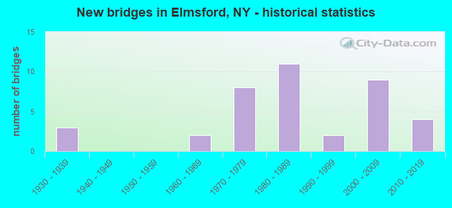
- New bridges - historical statistics
- 31930-1939
- 21960-1969
- 81970-1979
- 111980-1989
- 21990-1999
- 92000-2009
- 42010-2019

- Reconstructed bridges - Historical Statistics
- 11990-1999
- 32000-2009


- Bridge Condition - Deck
- 10.0%Excellent
- 15.0%Very good
- 40.0%Good
- 20.0%Satisfactory
- 10.0%Fair
- 5.0%Poor

- Bridge Condition - Superstructure
- 15.0%Excellent
- 15.0%Very good
- 45.0%Good
- 10.0%Satisfactory
- 15.0%Fair

- Bridge Condition - Substructure
- 20.0%Very good
- 20.0%Good
- 30.0%Satisfactory
- 30.0%Fair

- Bridge Condition - Channel
- 50.0%Good
- 50.0%Satisfactory
Find on map >> Show street view
Structure Number: 1006109, Location: JCT RTS 9A+I287 (Lat: 41.057994, Lng: -73.816831), Route carried "on" structure: Interstate 287, Year Built: 2004, Status: Open, Structure Length: 4.42m (14.50ft), Average Daily Traffic: 80,071 (year 2019), Truck Traffic: 16%, Average Future Daily Traffic: 135,592 (year 2040), Design Load: HS 25 or greater, Features Intersected: RTE 9A
Minimum Vertical Clearance: 30+ m (98+ ft), Kilometerpoint: 7.064, Lanes on structure: 6, Lanes under structure: 5, Base Highway Network: Yes, Owner: State Highway Agency, Approaching Roadway Width: 35.7m (117.1ft), Skew: 22 degrees, Material/Design: Prestressed concrete, Design/Construction: Stringer/Multi-beam, Number Of Spans In Main Unit: 1, Length of Maximum Span: 42.3m (138.8ft), Curb-To-Curb Width: 34.9m (114.5ft), Out-to-Out Width: 36.5m (119.8ft)
Condition: Deck: Satisfactory, Superstructure: Good, Substructure: Good, Inventory Rating: 40.8 metric tons, Method Used To Determine Inventory Rating: Load Factor (LF), Structural Evaluation: Better than present minimum criteria, Deck Geometry: Superior to present desirable criteria, Underclear: Somewhat better than minimum adequacy, Approach Roadway Alignment: Equal to present desirable criteria, Length Of Structure Improvement: 4.41m (14.47ft), Designated Inspection Frequency: Every 24 months, Inspection Date: July 2020, Bridge Improvement Cost: $6,290,000, Roadway Improvement Cost: $3,683,000, Total Project Cost: $9,973,000 ( Estimate for 2021), Deck Structure Type: Concrete Cast-file-Place, Wearing Surface/Protective System: Wearing Surface: Integral Concrete, Deck Protection: Galvanized Reinforcing
Find on map >> Show street view
Structure Number: 1037229, Location: ROUTE 287I INT (Lat: 41.059292, Lng: -73.828656), Route carried "on" structure: Interstate 287, Year Built: 2003, Status: Open, Structure Length: 7.13m (23.39ft), Average Daily Traffic: 66,018 (year 2019), Truck Traffic: 15%, Average Future Daily Traffic: 111,794 (year 2040), Design Load: HS 25 or greater, Features Intersected: RTE 119
Minimum Vertical Clearance: 30+ m (98+ ft), Kilometerpoint: 6.066, Lanes on structure: 10, Lanes under structure: 6, Base Highway Network: Yes, Owner: State Highway Agency, Approaching Roadway Width: 58.2m (190.9ft), Skew: 24 degrees, Material/Design: Steel, Design/Construction: Box Beam or Girders - Multiple, Number Of Spans In Main Unit: 1, Length of Maximum Span: 67.5m (221.5ft), Curb-To-Curb Width: 55.9m (183.4ft), Out-to-Out Width: 59.1m (193.9ft)
Condition: Deck: Good, Superstructure: Very good, Substructure: Good, Inventory Rating: 67.0 metric tons, Method Used To Determine Inventory Rating: Load Factor (LF), Structural Evaluation: Better than present minimum criteria, Deck Geometry: Superior to present desirable criteria, Underclear: Superior to present desirable criteria, Approach Roadway Alignment: Equal to present minimum criteria, Length Of Structure Improvement: 7.13m (23.39ft), Designated Inspection Frequency: Every 24 months, Inspection Date: September 2020, Bridge Improvement Cost: $15,354,000, Roadway Improvement Cost: $8,991,000, Total Project Cost: $24,346,000 ( Estimate for 2021), Deck Structure Type: Concrete Cast-file-Place, Wearing Surface/Protective System: Wearing Surface: Integral Concrete, Deck Protection: Galvanized Reinforcing
Find on map >> Show street view
Structure Number: 103724, Location: .1 MI E JCT SH 119 & SMRP (Lat: 41.055325, Lng: -73.820742), Route carried "on" structure: State highway 119, Year Built: 1938, Status: Open, Structure Length: 1.04m (3.41ft), Average Daily Traffic: 28,174 (year 2016), Truck Traffic: 6%, Average Future Daily Traffic: 28,306 (year 2040), Design Load: H 20, Features Intersected: SAW MILL RIVER
Minimum Vertical Clearance: 30+ m (98+ ft), Kilometerpoint: 3.765, Lanes on structure: 5, Base Highway Network: Yes, Owner: State Highway Agency, Approaching Roadway Width: 18.3m (60.0ft), Skew: 1 degrees, Material/Design: Concrete, Design/Construction: Culvert, Number Of Spans In Main Unit: 2, Length of Maximum Span: 4.5m (14.8ft), Curb or Sidewalk Widths: Left: 3.0m (9.8ft), Right: 3.0m (9.8ft), Curb-To-Curb Width: 18.3m (60.0ft), Out-to-Out Width: 25.1m (82.3ft)
Condition: Channel: Satisfactory, Culverts: Fair, Operating Rating: 38.1 metric tons, Method Used To Determine Operating Rating: Load Factor (LF), Inventory Rating: 22.7 metric tons, Method Used To Determine Inventory Rating: Load Factor (LF), Structural Evaluation: Somewhat better than minimum adequacy, Deck Geometry: High priority of replacement, Waterway Adequacy: Equal to present desirable criteria, Approach Roadway Alignment: Meets minimum limits, Length Of Structure Improvement: 1.03m (3.38ft), Designated Inspection Frequency: Every 24 months, Inspection Date: April 2020, Bridge Improvement Cost: $734,000, Roadway Improvement Cost: $430,000, Total Project Cost: $1,164,000 ( Estimate for 2021)
Find on map >> Show street view
Structure Number: 1044579, Location: JCT I287 & SMRP (Lat: 41.058711, Lng: -73.821014), Route carried "on" structure: Interstate 287, Year Built: 1999, Status: Open, Structure Length: 31.46m (103.22ft), Truck Traffic: 15%, Design Load: HS 25 or greater, Features Intersected: SAW MILL RVR PKWY NB, Ra
Minimum Vertical Clearance: 30+ m (98+ ft), Kilometerpoint: 6.565, Lanes on structure: 8, Lanes under structure: 7, Base Highway Network: Yes, Owner: State Highway Agency, Approaching Roadway Width: 44.2m (145.0ft), Skew: 20 degrees, Material/Design: Steel continuous, Design/Construction: Box Beam or Girders - Single/Spread, Number Of Spans In Main Unit: 7, Length of Maximum Span: 56.0m (183.7ft), Curb-To-Curb Width: 44.1m (144.7ft), Out-to-Out Width: 45.8m (150.3ft)
Condition: Deck: Good, Superstructure: Very good, Substructure: Good, Channel: Good, Operating Rating: 69.9 metric tons, Method Used To Determine Operating Rating: Load Factor (LF), Inventory Rating: 41.7 metric tons, Method Used To Determine Inventory Rating: Load Factor (LF), Structural Evaluation: Better than present minimum criteria, Deck Geometry: Superior to present desirable criteria, Underclear: High priority of corrective action, Waterway Adequacy: Equal to present desirable criteria, Approach Roadway Alignment: Equal to present desirable criteria, Length Of Structure Improvement: 31.45m (103.18ft), Designated Inspection Frequency: Every 24 months, Inspection Date: December 2021, Bridge Improvement Cost: $33,022,000, Roadway Improvement Cost: $19,338,000, Total Project Cost: $52,360,000 ( Estimate for 2021), Deck Structure Type: Concrete Precast Panels, Wearing Surface/Protective System: Wearing Surface: Bituminous
Find on map >> Show street view
Structure Number: 104459, Location: .5 MI E JCT I287 & SMRP (Lat: 41.056992, Lng: -73.812656), Route carried "on" structure: Other road , Year Built: 2005, Status: Open, Structure Length: 4.63m (15.19ft), Average Daily Traffic: 1,574 (year 2020), Truck Traffic: 2%, Average Future Daily Traffic: 2,204 (year 2040), Design Load: HS 25 or greater, Features Intersected: 287I287I87011009, RTE I2, Facility Carried by Structure: WINTHROP AVENUE
Minimum Vertical Clearance: 30+ m (98+ ft), Kilometerpoint: 0.483, Lanes on structure: 2, Lanes under structure: 8, Owner: State Highway Agency, Approaching Roadway Width: 9.1m (29.9ft), Material/Design: Steel, Design/Construction: Stringer/Multi-beam, Number Of Spans In Main Unit: 1, Length of Maximum Span: 45.6m (149.6ft), Curb or Sidewalk Widths: Left: 1.5m (4.9ft), Right: 1.5m (4.9ft), Curb-To-Curb Width: 9.2m (30.2ft), Out-to-Out Width: 13.0m (42.7ft)
Condition: Deck: Good, Superstructure: Good, Substructure: Very good, Operating Rating: 82.6 metric tons, Method Used To Determine Operating Rating: Load and Resistance Factor Rating (LRFR) rating reported by rating factor(RF) method using HL-93 loadings, Inventory Rating: 63.8 metric tons, Method Used To Determine Inventory Rating: Load and Resistance Factor Rating (LRFR) rating reported by rating factor(RF) method using HL-93 loadings, Structural Evaluation: Better than present minimum criteria, Deck Geometry: Somewhat better than minimum adequacy, Underclear: High priority of corrective action, Approach Roadway Alignment: Equal to present desirable criteria, Length Of Structure Improvement: 4.63m (15.19ft), Designated Inspection Frequency: Every 24 months, Inspection Date: October 2020, Bridge Improvement Cost: $2,540,000, Roadway Improvement Cost: $1,487,000, Total Project Cost: $4,027,000 ( Estimate for 2021), Deck Structure Type: Concrete Cast-file-Place, Wearing Surface/Protective System: Wearing Surface: Integral Concrete, Deck Protection: Galvanized Reinforcing
Find on map >> Show street view
Structure Number: 1044619, Location: 0.6 MI E JCT RTS I287+9A (Lat: 41.050781, Lng: -73.808100), Route carried "on" structure: Interstate 287, Year Built: 2004, Status: Open, Structure Length: 5.55m (18.21ft), Average Daily Traffic: 80,071 (year 2019), Truck Traffic: 16%, Average Future Daily Traffic: 135,592 (year 2040), Design Load: HS 25 or greater, Features Intersected: CATSKILL AQUEDUCT
Minimum Vertical Clearance: 30+ m (98+ ft), Kilometerpoint: 8.125, Lanes on structure: 8, Base Highway Network: Yes, Owner: State Highway Agency, Approaching Roadway Width: 41.5m (136.2ft), Skew: 24 degrees, Material/Design: Prestressed concrete, Design/Construction: Stringer/Multi-beam, Number Of Spans In Main Unit: 3, Length of Maximum Span: 20.4m (66.9ft), Curb-To-Curb Width: 39.3m (128.9ft), Out-to-Out Width: 42.4m (139.1ft)
Condition: Deck: Very good, Superstructure: Very good, Substructure: Very good, Operating Rating: 70.4 metric tons, Method Used To Determine Operating Rating: Load Factor (LF), Inventory Rating: 42.2 metric tons, Method Used To Determine Inventory Rating: Load Factor (LF), Structural Evaluation: Equal to present desirable criteria, Deck Geometry: Superior to present desirable criteria, Approach Roadway Alignment: Equal to present desirable criteria, Length Of Structure Improvement: 5.54m (18.18ft), Designated Inspection Frequency: Every 24 months, Inspection Date: September 2020, Bridge Improvement Cost: $10,170,000, Roadway Improvement Cost: $5,955,000, Total Project Cost: $16,125,000 ( Estimate for 2021), Deck Structure Type: Concrete Cast-file-Place, Wearing Surface/Protective System: Wearing Surface: Monolithic Concrete, Deck Protection: Galvanized Reinforcing
Find on map >> Show street view
Structure Number: 107044, Location: .2 MI W JCT I287 & SMRP (Lat: 41.058672, Lng: -73.825456), Route carried "on" structure: Ramp Other road , Year Built: 1981, Year Reconstructed: 2003, Status: Open, Structure Length: 4.24m (13.91ft), Average Daily Traffic: 11,018 (year 2016), Truck Traffic: 15%, Average Future Daily Traffic: 18,657 (year 2040), Design Load: HS 20, Features Intersected: RAMP D TO SMRP, Facility Carried by Structure: RAMP S TO SMRP
Minimum Vertical Clearance: 30+ m (98+ ft), Kilometerpoint: 1.191, Lanes on structure: 1, Lanes under structure: 2, Owner: State Highway Agency, Approaching Roadway Width: 7.0m (23.0ft), Skew: 2 degrees, Material/Design: Prestressed concrete continuous, Design/Construction: Box Beam or Girders - Multiple, Number Of Spans In Main Unit: 3, Length of Maximum Span: 20.7m (67.9ft), Curb-To-Curb Width: 6.7m (22.0ft), Out-to-Out Width: 7.7m (25.3ft)
Condition: Deck: Satisfactory, Superstructure: Good, Substructure: Fair, Operating Rating: 78.0 metric tons, Method Used To Determine Operating Rating: Load Factor (LF), Inventory Rating: 37.2 metric tons, Method Used To Determine Inventory Rating: Load Factor (LF), Structural Evaluation: Somewhat better than minimum adequacy, Deck Geometry: Equal to present minimum criteria, Underclear: Equal to present minimum criteria, Approach Roadway Alignment: Equal to present desirable criteria, Length Of Structure Improvement: 4.23m (13.88ft), Designated Inspection Frequency: Every 24 months, Inspection Date: July 2020, Bridge Improvement Cost: $854,000, Roadway Improvement Cost: $500,000, Total Project Cost: $1,354,000 ( Estimate for 2021), Wearing Surface/Protective System: Wearing Surface: Bituminous, Membrane: Epoxy
Find on map >> Show street view
Structure Number: 107045, Location: 1.5 MI N INT 287I & SBSP (Lat: 41.073728, Lng: -73.801806), Route carried "on" structure: State highway 100C, Year Built: 1981, Year Reconstructed: 2013, Status: Open, Structure Length: 7.53m (24.70ft), Average Daily Traffic: 19,381 (year 2017), Truck Traffic: 6%, Average Future Daily Traffic: 19,472 (year 2040), Design Load: HS 20, Features Intersected: 987F 987F87012066 SB, RT
Minimum Vertical Clearance: 30+ m (98+ ft), Kilometerpoint: 1.802, Lanes on structure: 5, Lanes under structure: 7, Base Highway Network: Yes, Owner: State Highway Agency, Approaching Roadway Width: 25.6m (84.0ft), Skew: 31 degrees, Material/Design: Steel, Design/Construction: Stringer/Multi-beam, Number Of Spans In Main Unit: 2, Length of Maximum Span: 39.3m (128.9ft), Curb-To-Curb Width: 24.6m (80.7ft), Out-to-Out Width: 26.2m (86.0ft)
Condition: Deck: Very good, Superstructure: Good, Substructure: Satisfactory, Operating Rating: 86.2 metric tons, Method Used To Determine Operating Rating: Load Factor (LF), Inventory Rating: 50.8 metric tons, Method Used To Determine Inventory Rating: Load Factor (LF), Structural Evaluation: Equal to present minimum criteria, Deck Geometry: Superior to present desirable criteria, Underclear: Meets minimum limits, Approach Roadway Alignment: Equal to present desirable criteria, Length Of Structure Improvement: 7.52m (24.67ft), Designated Inspection Frequency: Every 24 months, Inspection Date: October 2021, Bridge Improvement Cost: $8,158,000, Roadway Improvement Cost: $4,777,000, Total Project Cost: $12,936,000 ( Estimate for 2021), Deck Structure Type: Concrete Cast-file-Place, Wearing Surface/Protective System: Wearing Surface: Integral Concrete, Deck Protection: Epoxy Coated Reinforcing
Find on map >> Show street view
Structure Number: 1070461, Location: 0.4MI N INT 287I & SBSP (Lat: 41.059594, Lng: -73.808836), Route carried "on" structure: Other road 987F, Year Built: 1981, Status: Open, Structure Length: 2.65m (8.69ft), Average Daily Traffic: 43,572 (year 2014), Truck Traffic: 1%, Average Future Daily Traffic: 61,467 (year 2040), Design Load: HS 20, Features Intersected: CATSKILL AQUEDUCT
Minimum Vertical Clearance: 30+ m (98+ ft), Kilometerpoint: 15.173, Lanes on structure: 3, Base Highway Network: Yes, Owner: State Highway Agency, Approaching Roadway Width: 15.8m (51.8ft), Skew: 4 degrees, Material/Design: Prestressed concrete, Design/Construction: Box Beam or Girders - Multiple, Number Of Spans In Main Unit: 1, Length of Maximum Span: 25.2m (82.7ft), Curb-To-Curb Width: 15.5m (50.9ft), Out-to-Out Width: 16.7m (54.8ft)
Condition: Deck: Fair, Superstructure: Satisfactory, Substructure: Satisfactory, Operating Rating: 98.9 metric tons, Method Used To Determine Operating Rating: Load Factor (LF), Inventory Rating: 59.0 metric tons, Method Used To Determine Inventory Rating: Load Factor (LF), Structural Evaluation: Equal to present minimum criteria, Deck Geometry: Somewhat better than minimum adequacy, Approach Roadway Alignment: Equal to present desirable criteria, Length Of Structure Improvement: 2.65m (8.69ft), Designated Inspection Frequency: Every 24 months, Inspection Date: May 2020, Bridge Improvement Cost: $1,699,000, Roadway Improvement Cost: $995,000, Total Project Cost: $2,694,000 ( Estimate for 2021), Wearing Surface/Protective System: Wearing Surface: Integral Concrete
Find on map >> Show street view
Structure Number: 1070462, Location: 0.4MI N INT 287I & SBSP (Lat: 41.059331, Lng: -73.808694), Route carried "on" structure: Other road 987F, Year Built: 1981, Status: Open, Structure Length: 2.65m (8.69ft), Average Daily Traffic: 43,572 (year 2014), Truck Traffic: 1%, Average Future Daily Traffic: 61,467 (year 2040), Design Load: HS 20, Features Intersected: CATSKILL AQUEDUCT
Minimum Vertical Clearance: 30+ m (98+ ft), Kilometerpoint: 15.141, Lanes on structure: 3, Base Highway Network: Yes, Owner: State Highway Agency, Approaching Roadway Width: 15.8m (51.8ft), Skew: 4 degrees, Material/Design: Prestressed concrete, Design/Construction: Box Beam or Girders - Multiple, Number Of Spans In Main Unit: 1, Length of Maximum Span: 25.2m (82.7ft), Curb-To-Curb Width: 16.7m (54.8ft), Out-to-Out Width: 18.3m (60.0ft)
Condition: Deck: Fair, Superstructure: Fair, Substructure: Satisfactory, Operating Rating: 98.9 metric tons, Method Used To Determine Operating Rating: Load Factor (LF), Inventory Rating: 59.0 metric tons, Method Used To Determine Inventory Rating: Load Factor (LF), Structural Evaluation: Somewhat better than minimum adequacy, Deck Geometry: Equal to present minimum criteria, Approach Roadway Alignment: Equal to present desirable criteria, Length Of Structure Improvement: 2.65m (8.69ft), Designated Inspection Frequency: Every 24 months, Inspection Date: May 2020, Bridge Improvement Cost: $1,486,000, Roadway Improvement Cost: $870,000, Total Project Cost: $2,357,000 ( Estimate for 2021), Wearing Surface/Protective System: Wearing Surface: Integral Concrete
Find on map >> Show street view
Structure Number: 1070471, Location: 0.3MI N INT 287I & SBSP (Lat: 41.058378, Lng: -73.809397), Route carried "on" structure: Other road 987F, Year Built: 1981, Status: Open, Structure Length: 3.81m (12.50ft), Average Daily Traffic: 43,572 (year 2014), Truck Traffic: 1%, Average Future Daily Traffic: 61,467 (year 2040), Design Load: HS 20, Features Intersected: ES RAMP TO SBSP
Minimum Vertical Clearance: 30+ m (98+ ft), Kilometerpoint: 15.028, Lanes on structure: 3, Lanes under structure: 1, Base Highway Network: Yes, Owner: State Highway Agency, Approaching Roadway Width: 15.8m (51.8ft), Skew: 3 degrees, Material/Design: Steel, Design/Construction: Stringer/Multi-beam, Number Of Spans In Main Unit: 1, Length of Maximum Span: 37.1m (121.7ft), Curb-To-Curb Width: 15.7m (51.5ft), Out-to-Out Width: 16.6m (54.5ft)
Condition: Deck: Good, Superstructure: Good, Substructure: Fair, Operating Rating: 75.8 metric tons, Method Used To Determine Operating Rating: Load and Resistance Factor Rating (LRFR) rating reported by rating factor(RF) method using HL-93 loadings, Inventory Rating: 58.6 metric tons, Method Used To Determine Inventory Rating: Load and Resistance Factor Rating (LRFR) rating reported by rating factor(RF) method using HL-93 loadings, Structural Evaluation: Somewhat better than minimum adequacy, Deck Geometry: Somewhat better than minimum adequacy, Underclear: Equal to present minimum criteria, Approach Roadway Alignment: Equal to present desirable criteria, Length Of Structure Improvement: 3.81m (12.50ft), Designated Inspection Frequency: Every 24 months, Inspection Date: July 2020, Bridge Improvement Cost: $3,256,000, Roadway Improvement Cost: $1,907,000, Total Project Cost: $5,163,000 ( Estimate for 2021), Deck Structure Type: Concrete Cast-file-Place, Wearing Surface/Protective System: Wearing Surface: Monolithic Concrete
Find on map >> Show street view
Structure Number: 1070472, Location: 0.3MI N INT 287I & SBSP (Lat: 41.058392, Lng: -73.809072), Route carried "on" structure: Other road 987F, Year Built: 1981, Status: Open, Structure Length: 3.41m (11.19ft), Average Daily Traffic: 43,572 (year 2014), Truck Traffic: 1%, Average Future Daily Traffic: 61,467 (year 2040), Design Load: HS 20, Features Intersected: ES RAMP TO SBSP
Minimum Vertical Clearance: 30+ m (98+ ft), Kilometerpoint: 15.028, Lanes on structure: 3, Lanes under structure: 1, Base Highway Network: Yes, Owner: State Highway Agency, Approaching Roadway Width: 18.3m (60.0ft), Material/Design: Steel, Design/Construction: Stringer/Multi-beam, Number Of Spans In Main Unit: 1, Length of Maximum Span: 33.2m (108.9ft), Curb-To-Curb Width: 17.9m (58.7ft), Out-to-Out Width: 18.8m (61.7ft)
Condition: Deck: Good, Superstructure: Good, Substructure: Fair, Operating Rating: 61.2 metric tons, Method Used To Determine Operating Rating: Load and Resistance Factor Rating (LRFR) rating reported by rating factor(RF) method using HL-93 loadings, Inventory Rating: 47.3 metric tons, Method Used To Determine Inventory Rating: Load and Resistance Factor Rating (LRFR) rating reported by rating factor(RF) method using HL-93 loadings, Structural Evaluation: Somewhat better than minimum adequacy, Deck Geometry: Better than present minimum criteria, Underclear: Equal to present minimum criteria, Approach Roadway Alignment: Equal to present desirable criteria, Length Of Structure Improvement: 3.41m (11.19ft), Designated Inspection Frequency: Every 24 months, Inspection Date: July 2020, Bridge Improvement Cost: $3,222,000, Roadway Improvement Cost: $1,887,000, Total Project Cost: $5,108,000 ( Estimate for 2021), Deck Structure Type: Concrete Cast-file-Place, Wearing Surface/Protective System: Wearing Surface: Monolithic Concrete
Find on map >> Show street view
Structure Number: 107049, Location: 0.1 MI S INT 287I & SMRP (Lat: 41.058086, Lng: -73.822319), Route carried "on" structure: Ramp Other road , Year Built: 1977, Status: Open, Structure Length: 6.04m (19.82ft), Average Daily Traffic: 5,561 (year 2020), Average Future Daily Traffic: 9,416 (year 2040), Design Load: HS 20, Features Intersected: 987D987D87012060 NB, RT, Facility Carried by Structure: SM RAMP FROM CWE
Minimum Vertical Clearance: 30+ m (98+ ft), Kilometerpoint: 1.400, Lanes on structure: 1, Lanes under structure: 5, Owner: State Highway Agency, Approaching Roadway Width: 6.7m (22.0ft), Material/Design: Steel continuous, Design/Construction: Stringer/Multi-beam, Number Of Spans In Main Unit: 2, Length of Maximum Span: 29.6m (97.1ft), Curb-To-Curb Width: 6.7m (22.0ft), Out-to-Out Width: 7.6m (24.9ft)
Condition: Deck: Satisfactory, Superstructure: Good, Substructure: Satisfactory, Operating Rating: 41.1 metric tons, Method Used To Determine Operating Rating: Load and Resistance Factor Rating (LRFR) rating reported by rating factor(RF) method using HL-93 loadings, Inventory Rating: 31.8 metric tons, Method Used To Determine Inventory Rating: Load and Resistance Factor Rating (LRFR) rating reported by rating factor(RF) method using HL-93 loadings, Structural Evaluation: Equal to present minimum criteria, Deck Geometry: Equal to present minimum criteria, Underclear: High priority of corrective action, Approach Roadway Alignment: Equal to present desirable criteria, Length Of Structure Improvement: 6.03m (19.78ft), Designated Inspection Frequency: Every 24 months, Critical Feature Inspection Frequency: Every 24 months, Inspection Date: October 2021, Critical Feature Inspection Date: October 2021, Bridge Improvement Cost: $1,802,000, Roadway Improvement Cost: $1,055,000, Total Project Cost: $2,857,000 ( Estimate for 2021), Deck Structure Type: Concrete Cast-file-Place, Wearing Surface/Protective System: Wearing Surface: Integral Concrete
Find on map >> Show street view
Structure Number: 107051, Location: S OF INT 287I & SBSP (Lat: 41.051181, Lng: -73.809189), Route carried "on" structure: Ramp Other road , Year Built: 1981, Status: Open, Structure Length: 5.43m (17.81ft), Average Daily Traffic: 7,620 (year 2016), Truck Traffic: 1%, Average Future Daily Traffic: 12,903 (year 2040), Design Load: HS 20, Features Intersected: CATSKILL AQUEDUCT, Facility Carried by Structure: SE RAMP 987F
Minimum Vertical Clearance: 30+ m (98+ ft), Kilometerpoint: 0.274, Lanes on structure: 1, Owner: State Highway Agency, Approaching Roadway Width: 7.0m (23.0ft), Skew: 1 degrees, Material/Design: Prestressed concrete, Design/Construction: Box Beam or Girders - Multiple, Number Of Spans In Main Unit: 4, Length of Maximum Span: 13.4m (44.0ft), Curb-To-Curb Width: 6.9m (22.6ft), Out-to-Out Width: 7.6m (24.9ft)
Condition: Deck: Good, Superstructure: Satisfactory, Substructure: Satisfactory, Operating Rating: 66.2 metric tons, Method Used To Determine Operating Rating: Load Factor (LF), Inventory Rating: 27.2 metric tons, Method Used To Determine Inventory Rating: Load Factor (LF), Structural Evaluation: Equal to present minimum criteria, Deck Geometry: Equal to present minimum criteria, Approach Roadway Alignment: Equal to present desirable criteria, Length Of Structure Improvement: 5.42m (17.78ft), Designated Inspection Frequency: Every 24 months, Inspection Date: May 2020, Bridge Improvement Cost: $1,083,000, Roadway Improvement Cost: $634,000, Total Project Cost: $1,717,000 ( Estimate for 2021), Wearing Surface/Protective System: Wearing Surface: Bituminous
Find on map >> Show street view
Structure Number: 107793, Location: JCT I287 & SAWMILL PKWY (Lat: 41.059686, Lng: -73.825731), Route carried "on" structure: Ramp Interstate 987D, Year Built: 2004, Status: Open, Structure Length: 3.35m (10.99ft), Average Daily Traffic: 6,038 (year 2020), Truck Traffic: 15%, Average Future Daily Traffic: 10,224 (year 2040), Design Load: HS 25 or greater, Features Intersected: RAMPA I287 TO 1
Minimum Vertical Clearance: 30+ m (98+ ft), Kilometerpoint: 0.177, Lanes on structure: 1, Lanes under structure: 2, Owner: State Highway Agency, Approaching Roadway Width: 7.6m (24.9ft), Skew: 3 degrees, Material/Design: Steel, Design/Construction: Stringer/Multi-beam, Number Of Spans In Main Unit: 1, Length of Maximum Span: 32.0m (105.0ft), Curb-To-Curb Width: 9.0m (29.5ft), Out-to-Out Width: 9.9m (32.5ft)
Condition: Deck: Excellent, Superstructure: Excellent, Substructure: Good, Operating Rating: 75.0 metric tons, Method Used To Determine Operating Rating: Load Factor (LF), Inventory Rating: 44.9 metric tons, Method Used To Determine Inventory Rating: Load Factor (LF), Structural Evaluation: Better than present minimum criteria, Deck Geometry: Superior to present desirable criteria, Underclear: High priority of corrective action, Approach Roadway Alignment: Equal to present desirable criteria, Length Of Structure Improvement: 3.35m (10.99ft), Designated Inspection Frequency: Every 24 months, Inspection Date: July 2020, Bridge Improvement Cost: $1,906,000, Roadway Improvement Cost: $1,116,000, Total Project Cost: $3,022,000 ( Estimate for 2021), Deck Structure Type: Concrete Cast-file-Place, Wearing Surface/Protective System: Wearing Surface: Integral Concrete, Deck Protection: Galvanized Reinforcing
Find on map >> Show street view
Structure Number: 50532, Location: JCT SBSP&I287 AT ELMSFORD (Lat: 41.053889, Lng: -73.809567), Route carried "on" structure: Other road 987F, Year Built: 1970, Year Reconstructed: 2005, Status: Open, Structure Length: 11.34m (37.20ft), Average Daily Traffic: 96,840 (year 2014), Truck Traffic: 1%, Average Future Daily Traffic: 136,612 (year 2040), Design Load: HS 25 or greater, Features Intersected: 287I287I87011011, RTE I2
Minimum Vertical Clearance: 30+ m (98+ ft), Kilometerpoint: 14.449, Lanes on structure: 4, Lanes under structure: 7, Base Highway Network: Yes, Owner: State Highway Agency, Approaching Roadway Width: 15.3m (50.2ft), Skew: 5 degrees, Material/Design: Steel, Design/Construction: Stringer/Multi-beam, Number Of Spans In Main Unit: 3, Length of Maximum Span: 41.8m (137.1ft), Curb-To-Curb Width: 15.3m (50.2ft), Out-to-Out Width: 17.0m (55.8ft)
Condition: Deck: Satisfactory, Superstructure: Good, Substructure: Fair, Operating Rating: 78.9 metric tons, Method Used To Determine Operating Rating: Load Factor (LF), Inventory Rating: 47.2 metric tons, Method Used To Determine Inventory Rating: Load Factor (LF), Structural Evaluation: Somewhat better than minimum adequacy, Deck Geometry: High priority of replacement, Underclear: High priority of corrective action, Approach Roadway Alignment: Equal to present desirable criteria, Length Of Structure Improvement: 11.33m (37.17ft), Designated Inspection Frequency: Every 24 months, Inspection Date: December 2020, Bridge Improvement Cost: $10,002,000, Roadway Improvement Cost: $5,857,000, Total Project Cost: $15,859,000 ( Estimate for 2021), Deck Structure Type: Concrete Cast-file-Place, Wearing Surface/Protective System: Wearing Surface: Bituminous, Membrane: Other
Find on map >> Show street view
Structure Number: 505321, Location: JCT SBSP&I287 AT ELMSFORD (Lat: 41.055114, Lng: -73.810406), Route carried "on" structure: Other road 987F, Year Built: 1970, Year Reconstructed: 2005, Status: Open, Structure Length: 11.95m (39.21ft), Average Daily Traffic: 87,144 (year 2014), Truck Traffic: 1%, Average Future Daily Traffic: 122,934 (year 2040), Design Load: HS 25 or greater, Features Intersected: 287I287I87011011, RTE I2
Minimum Vertical Clearance: 30+ m (98+ ft), Kilometerpoint: 14.626, Lanes on structure: 4, Lanes under structure: 7, Base Highway Network: Yes, Owner: State Highway Agency, Approaching Roadway Width: 15.3m (50.2ft), Skew: 6 degrees, Material/Design: Steel, Design/Construction: Stringer/Multi-beam, Number Of Spans In Main Unit: 4, Length of Maximum Span: 34.4m (112.9ft), Curb-To-Curb Width: 15.3m (50.2ft), Out-to-Out Width: 17.0m (55.8ft)
Condition: Deck: Good, Superstructure: Good, Substructure: Fair, Operating Rating: 71.7 metric tons, Method Used To Determine Operating Rating: Load Factor (LF), Inventory Rating: 42.6 metric tons, Method Used To Determine Inventory Rating: Load Factor (LF), Structural Evaluation: Somewhat better than minimum adequacy, Deck Geometry: High priority of replacement, Underclear: High priority of corrective action, Approach Roadway Alignment: Equal to present desirable criteria, Length Of Structure Improvement: 11.94m (39.17ft), Designated Inspection Frequency: Every 24 months, Inspection Date: December 2020, Bridge Improvement Cost: $10,145,000, Roadway Improvement Cost: $5,941,000, Total Project Cost: $16,085,000 ( Estimate for 2021), Deck Structure Type: Concrete Cast-file-Place, Wearing Surface/Protective System: Wearing Surface: Monolithic Concrete
Find on map >> Show street view
Structure Number: 5053371, Location: JCT SBSP&119 AT ELMSFORD (Lat: 41.050244, Lng: -73.810889), Route carried "on" structure: Other road 987F, Year Built: 2013, Status: Open, Structure Length: 5.70m (18.70ft), Average Daily Traffic: 48,420 (year 2014), Truck Traffic: 1%, Average Future Daily Traffic: 68,306 (year 2040), Design Load: HL 93, Features Intersected: RTE 119
Minimum Vertical Clearance: 30+ m (98+ ft), Kilometerpoint: 14.063, Lanes on structure: 3, Lanes under structure: 4, Base Highway Network: Yes, Owner: State Highway Agency, Approaching Roadway Width: 14.9m (48.9ft), Skew: 2 degrees, Material/Design: Steel, Design/Construction: Stringer/Multi-beam, Number Of Spans In Main Unit: 1, Length of Maximum Span: 55.2m (181.1ft), Curb-To-Curb Width: 15.0m (49.2ft), Out-to-Out Width: 15.9m (52.2ft)
Condition: Deck: Very good, Superstructure: Excellent, Substructure: Very good, Inventory Rating: 71.7 metric tons, Method Used To Determine Inventory Rating: Load Factor (LF), Structural Evaluation: Equal to present desirable criteria, Deck Geometry: Meets minimum limits, Underclear: Meets minimum limits, Approach Roadway Alignment: Equal to present desirable criteria, Length Of Structure Improvement: 5.69m (18.67ft), Designated Inspection Frequency: Every 24 months, Inspection Date: May 2021, Bridge Improvement Cost: $3,988,000, Roadway Improvement Cost: $2,335,000, Total Project Cost: $6,324,000 ( Estimate for 2021), Deck Structure Type: Concrete Cast-file-Place, Wearing Surface/Protective System: Wearing Surface: Integral Concrete, Deck Protection: Epoxy Coated Reinforcing
Find on map >> Show street view
Structure Number: 5053372, Location: JCT SBSP&119 AT ELMSFORD (Lat: 41.050122, Lng: -73.810703), Route carried "on" structure: Other road 987F, Year Built: 2013, Status: Open, Structure Length: 5.58m (18.31ft), Average Daily Traffic: 48,420 (year 2014), Truck Traffic: 1%, Average Future Daily Traffic: 68,306 (year 2040), Design Load: HL 93, Features Intersected: RTE 119
Minimum Vertical Clearance: 30+ m (98+ ft), Kilometerpoint: 14.063, Lanes on structure: 3, Lanes under structure: 4, Base Highway Network: Yes, Owner: State Highway Agency, Approaching Roadway Width: 18.3m (60.0ft), Skew: 2 degrees, Material/Design: Steel, Design/Construction: Stringer/Multi-beam, Number Of Spans In Main Unit: 1, Length of Maximum Span: 53.9m (176.8ft), Curb-To-Curb Width: 18.2m (59.7ft), Out-to-Out Width: 19.1m (62.7ft)
Condition: Deck: Excellent, Superstructure: Excellent, Substructure: Very good, Operating Rating: 74.5 metric tons, Method Used To Determine Operating Rating: Load and Resistance Factor Rating (LRFR) rating reported by rating factor(RF) method using HL-93 loadings, Inventory Rating: 57.3 metric tons, Method Used To Determine Inventory Rating: Load and Resistance Factor Rating (LRFR) rating reported by rating factor(RF) method using HL-93 loadings, Structural Evaluation: Equal to present desirable criteria, Deck Geometry: Better than present minimum criteria, Underclear: Meets minimum limits, Approach Roadway Alignment: Equal to present desirable criteria, Length Of Structure Improvement: 5.57m (18.27ft), Designated Inspection Frequency: Every 24 months, Inspection Date: May 2021, Bridge Improvement Cost: $6,179,000, Roadway Improvement Cost: $3,618,000, Total Project Cost: $9,797,000 ( Estimate for 2021), Deck Structure Type: Concrete Cast-file-Place, Wearing Surface/Protective System: Wearing Surface: Integral Concrete, Deck Protection: Epoxy Coated Reinforcing
Find on map >> Show street view
Structure Number: 5500749, Location: 1.2 MI N JCT RTS SMRP&I87 (Lat: 41.055567, Lng: -73.821272), Route carried "on" structure: Other road 987D, Year Built: 1934, Status: Open, Structure Length: 2.71m (8.89ft), Truck Traffic: 2%, Features Intersected: RTE 119
Minimum Vertical Clearance: 30+ m (98+ ft), Kilometerpoint: 17.828, Lanes on structure: 4, Lanes under structure: 5, Base Highway Network: Yes, Owner: State Highway Agency, Approaching Roadway Width: 13.4m (44.0ft), Skew: 31 degrees, Material/Design: Steel, Design/Construction: Frame, Number Of Spans In Main Unit: 1, Length of Maximum Span: 26.5m (86.9ft), Curb or Sidewalk Widths: Left: 3.3m (10.8ft), Right: 2.2m (7.2ft), Curb-To-Curb Width: 13.3m (43.6ft), Out-to-Out Width: 21.5m (70.5ft)
Condition: Deck: Poor, Superstructure: Fair, Substructure: Satisfactory, Operating Rating: 54.4 metric tons, Method Used To Determine Operating Rating: Load Factor (LF), Inventory Rating: 32.7 metric tons, Method Used To Determine Inventory Rating: Load Factor (LF), Structural Evaluation: Somewhat better than minimum adequacy, Deck Geometry: High priority of replacement, Underclear: Somewhat better than minimum adequacy, Approach Roadway Alignment: Somewhat better than minimum adequacy, Length Of Structure Improvement: 2.71m (8.89ft), Designated Inspection Frequency: Every 24 months, Inspection Date: August 2020, Bridge Improvement Cost: $3,746,000, Roadway Improvement Cost: $2,194,000, Total Project Cost: $5,940,000 ( Estimate for 2021), Deck Structure Type: Concrete Cast-file-Place, Wearing Surface/Protective System: Wearing Surface: Bituminous
Find on map >> Show street view
Structure Number: 550171, Location: 0.5 MI S JCT RTS SBSP+287 (Lat: 41.047814, Lng: -73.812494), Route carried "on" structure: Other road , Year Built: 1966, Status: Open, Structure Length: 3.81m (12.50ft), Average Daily Traffic: 2,223 (year 2014), Truck Traffic: 2%, Average Future Daily Traffic: 3,112 (year 2034), Design Load: HS 20, Features Intersected: 987FX SB, RTE 987F, Facility Carried by Structure: HARTSDALE ROAD
Minimum Vertical Clearance: 30+ m (98+ ft), Kilometerpoint: 0.788, Lanes on structure: 2, Lanes under structure: 6, Owner: State Highway Agency, Approaching Roadway Width: 10.1m (33.1ft), Skew: 1 degrees, Material/Design: Steel, Design/Construction: Stringer/Multi-beam, Number Of Spans In Main Unit: 2, Length of Maximum Span: 17.9m (58.7ft), Curb-To-Curb Width: 10.2m (33.5ft), Out-to-Out Width: 11.3m (37.1ft)
Condition: Deck: Good, Superstructure: Fair, Substructure: Fair, Operating Rating: 68.4 metric tons, Method Used To Determine Operating Rating: Load and Resistance Factor Rating (LRFR) rating reported by rating factor(RF) method using HL-93 loadings, Inventory Rating: 52.8 metric tons, Method Used To Determine Inventory Rating: Load and Resistance Factor Rating (LRFR) rating reported by rating factor(RF) method using HL-93 loadings, Structural Evaluation: Somewhat better than minimum adequacy, Deck Geometry: Meets minimum limits, Underclear: High priority of corrective action, Approach Roadway Alignment: Equal to present desirable criteria, Length Of Structure Improvement: 3.81m (12.50ft), Designated Inspection Frequency: Every 24 months, Inspection Date: August 2020, Bridge Improvement Cost: $2,464,000, Roadway Improvement Cost: $1,443,000, Total Project Cost: $3,906,000 ( Estimate for 2021), Deck Structure Type: Concrete Cast-file-Place, Wearing Surface/Protective System: Wearing Surface: Bituminous
Find on map >> Show street view
Structure Number: 1006109, Location: JCT RTS 9A+I287 (Lat: 41.057994, Lng: -73.816831), Route carried "under" structure: State highway 9A, Year Built: 2004, Structure Length: 0. m, Average Daily Traffic: 17,075 (year 2000), Features Intersected: RTE 9A, Facility Carried by Structure: RTE I287
Minimum Vertical Clearance: 4.88m (16.01ft), Kilometerpoint: 10.298, Lanes on structure: 6, Lanes under structure: 5, Material/Design: Prestressed concrete, Design/Construction: Stringer/Multi-beam, Length of Maximum Span: 42.3m (138.8ft)
Find on map >> Show street view
Structure Number: 1037229, Location: ROUTE 287I INT (Lat: 41.059292, Lng: -73.828656), Route carried "under" structure: State highway 119, Year Built: 2003, Structure Length: 0. m, Average Daily Traffic: 29,185 (year 1998), Features Intersected: RTE 119, Facility Carried by Structure: RTE I287
Minimum Vertical Clearance: 5.84m (19.16ft), Kilometerpoint: 3.347, Lanes on structure: 10, Lanes under structure: 6, Material/Design: Steel, Design/Construction: Box Beam or Girders - Multiple, Length of Maximum Span: 67.5m (221.5ft)
Find on map >> Show street view
Structure Number: 1044579, Location: JCT I287 & SMRP (Lat: 41.058711, Lng: -73.821014), Route carried "under" structure: State highway , Year Built: 1999, Structure Length: 0. m, Average Daily Traffic: 100 (year 1987), Features Intersected: SAW MILL RVR PKWY NB, Ra, Facility Carried by Structure: RTE I287
Minimum Vertical Clearance: 4.72m (15.49ft), Kilometerpoint: 18.182, Lanes on structure: 8, Lanes under structure: 1, Material/Design: Steel continuous, Design/Construction: Box Beam or Girders - Single/Spread, Length of Maximum Span: 56.0m (183.7ft)
Find on map >> Show street view
Structure Number: 104459, Location: .5 MI E JCT I287 & SMRP (Lat: 41.056992, Lng: -73.812656), Route carried "under" structure: Interstate 287, Year Built: 2005, Structure Length: 0. m, Average Daily Traffic: 68,077 (year 2002), Features Intersected: 287I287I87011009, RTE I2, Facility Carried by Structure: WINTHROP AVENUE
Minimum Vertical Clearance: 7.99m (26.21ft), Kilometerpoint: 1.512, Lanes on structure: 2, Lanes under structure: 4, Material/Design: Steel, Design/Construction: Stringer/Multi-beam, Length of Maximum Span: 45.6m (149.6ft)
Find on map >> Show street view
Structure Number: 107044, Location: .2 MI W JCT I287 & SMRP (Lat: 41.058672, Lng: -73.825456), Route carried "under" structure: Ramp Other road , Year Built: 1981, Structure Length: 0. m, Average Daily Traffic: 100 (year 2021), Features Intersected: RAMP D TO SMRP, Facility Carried by Structure: RAMP S TO SMRP
Minimum Vertical Clearance: 5.71m (18.73ft), Kilometerpoint: 0.000, Lanes on structure: 1, Lanes under structure: 2, Material/Design: Prestressed concrete continuous, Design/Construction: Box Beam or Girders - Multiple, Length of Maximum Span: 20.7m (67.9ft)
Find on map >> Show street view
Structure Number: 107045, Location: 1.5 MI N INT 287I & SBSP (Lat: 41.073728, Lng: -73.801806), Route carried "under" structure: Other road 987F, Year Built: 1981, Structure Length: 0. m, Average Daily Traffic: 100 (year 2021), Features Intersected: 987F 987F87012066 SB, RT, Facility Carried by Structure: RTE 100C
Minimum Vertical Clearance: 5.66m (18.57ft), Kilometerpoint: 33.242, Lanes on structure: 5, Lanes under structure: 3, Material/Design: Steel, Design/Construction: Stringer/Multi-beam, Length of Maximum Span: 39.3m (128.9ft)
Find on map >> Show street view
Structure Number: 1070471, Location: 0.3MI N INT 287I & SBSP (Lat: 41.058378, Lng: -73.809397), Route carried "under" structure: Ramp Other road , Year Built: 1981, Structure Length: 0. m, Average Daily Traffic: 100 (year 2021), Features Intersected: ES RAMP TO SBSP, Facility Carried by Structure: RTE 987F
Minimum Vertical Clearance: 4.75m (15.58ft), Kilometerpoint: 0.000, Lanes on structure: 3, Lanes under structure: 1, Material/Design: Steel, Design/Construction: Stringer/Multi-beam, Length of Maximum Span: 37.1m (121.7ft)
Find on map >> Show street view
Structure Number: 1070472, Location: 0.3MI N INT 287I & SBSP (Lat: 41.058392, Lng: -73.809072), Route carried "under" structure: Ramp Other road , Year Built: 1981, Structure Length: 0. m, Average Daily Traffic: 100 (year 2021), Features Intersected: ES RAMP TO SBSP, Facility Carried by Structure: RTE 987F
Minimum Vertical Clearance: 6.60m (21.65ft), Kilometerpoint: 0.000, Lanes on structure: 3, Lanes under structure: 1, Material/Design: Steel, Design/Construction: Stringer/Multi-beam, Length of Maximum Span: 33.2m (108.9ft)
Find on map >> Show street view
Structure Number: 107049, Location: 0.1 MI S INT 287I & SMRP (Lat: 41.058086, Lng: -73.822319), Route carried "under" structure: State highway 987D, Year Built: 1977, Structure Length: 0. m, Average Daily Traffic: 100 (year 2013), Features Intersected: 987D987D87012060 NB, RT, Facility Carried by Structure: SM RAMP FROM CWE
Minimum Vertical Clearance: 5.18m (16.99ft), Kilometerpoint: 18.021, Lanes on structure: 1, Lanes under structure: 2, Material/Design: Steel continuous, Design/Construction: Stringer/Multi-beam, Length of Maximum Span: 29.6m (97.1ft)
Find on map >> Show street view
Structure Number: 107793, Location: JCT I287 & SAWMILL PKWY (Lat: 41.059686, Lng: -73.825731), Route carried "under" structure: Ramp Interstate , Year Built: 2004, Structure Length: 0. m, Average Daily Traffic: 12,600 (year 1994), Features Intersected: RAMPA I287 TO 1, Facility Carried by Structure: RTE 987D
Minimum Vertical Clearance: 4.90m (16.08ft), Kilometerpoint: 0.000, Lanes on structure: 1, Lanes under structure: 2, Material/Design: Steel, Design/Construction: Stringer/Multi-beam, Length of Maximum Span: 32.0m (105.0ft)
Find on map >> Show street view
Structure Number: 50532, Location: JCT SBSP&I287 AT ELMSFORD (Lat: 41.053889, Lng: -73.809567), Route carried "under" structure: Interstate 287, Year Built: 1970, Structure Length: 0. m, Average Daily Traffic: 68,077 (year 2002), Features Intersected: 287I287I87011011, RTE I2, Facility Carried by Structure: RTE 987F
Minimum Vertical Clearance: 4.65m (15.26ft), Kilometerpoint: 1.770, Lanes on structure: 4, Lanes under structure: 3, Material/Design: Steel, Design/Construction: Stringer/Multi-beam, Length of Maximum Span: 41.8m (137.1ft)
Find on map >> Show street view
Structure Number: 50532, Location: JCT SBSP&I287 AT ELMSFORD (Lat: 41.053889, Lng: -73.809567), Route carried "under" structure: Interstate , Year Built: 1970, Structure Length: 0. m, Average Daily Traffic: 100 (year 2021), Features Intersected: 287I287I87011011, RTE I2, Facility Carried by Structure: RTE 987F
Minimum Vertical Clearance: 4.85m (15.91ft), Kilometerpoint: 1.770, Lanes on structure: 4, Lanes under structure: 1, Material/Design: Steel, Design/Construction: Stringer/Multi-beam, Length of Maximum Span: 41.8m (137.1ft)
Find on map >> Show street view
Structure Number: 505321, Location: JCT SBSP&I287 AT ELMSFORD (Lat: 41.055114, Lng: -73.810406), Route carried "under" structure: Interstate 287, Year Built: 1970, Structure Length: 0. m, Average Daily Traffic: 68,077 (year 2002), Features Intersected: 287I287I87011011, RTE I2, Facility Carried by Structure: RTE 987F
Minimum Vertical Clearance: 7.87m (25.82ft), Kilometerpoint: 1.770, Lanes on structure: 4, Lanes under structure: 3, Material/Design: Steel, Design/Construction: Stringer/Multi-beam, Length of Maximum Span: 34.4m (112.9ft)
Find on map >> Show street view
Structure Number: 505321, Location: JCT SBSP&I287 AT ELMSFORD (Lat: 41.055114, Lng: -73.810406), Route carried "under" structure: Interstate , Year Built: 1970, Structure Length: 0. m, Average Daily Traffic: 100 (year 2021), Features Intersected: 287I287I87011011, RTE I2, Facility Carried by Structure: RTE 987F
Minimum Vertical Clearance: 7.99m (26.21ft), Kilometerpoint: 1.770, Lanes on structure: 4, Lanes under structure: 1, Material/Design: Steel, Design/Construction: Stringer/Multi-beam, Length of Maximum Span: 34.4m (112.9ft)
Find on map >> Show street view
Structure Number: 5053371, Location: JCT SBSP&119 AT ELMSFORD (Lat: 41.050244, Lng: -73.810889), Route carried "under" structure: Business State highway 119, Year Built: 2013, Structure Length: 0. m, Average Daily Traffic: 21,787 (year 2002), Features Intersected: RTE 119, Facility Carried by Structure: RTE 987F
Minimum Vertical Clearance: 13.99m (45.90ft), Kilometerpoint: 4.827, Lanes on structure: 3, Lanes under structure: 4, Material/Design: Steel, Design/Construction: Stringer/Multi-beam, Length of Maximum Span: 55.2m (181.1ft)
Find on map >> Show street view
Structure Number: 5053372, Location: JCT SBSP&119 AT ELMSFORD (Lat: 41.050122, Lng: -73.810703), Route carried "under" structure: Business State highway 119, Year Built: 2013, Structure Length: 0. m, Average Daily Traffic: 21,787 (year 2002), Features Intersected: RTE 119, Facility Carried by Structure: RTE 987F
Minimum Vertical Clearance: 14.99m (49.18ft), Kilometerpoint: 4.827, Lanes on structure: 3, Lanes under structure: 4, Material/Design: Steel, Design/Construction: Stringer/Multi-beam, Length of Maximum Span: 53.9m (176.8ft)
Find on map >> Show street view
Structure Number: 5500749, Location: 1.2 MI N JCT RTS SMRP&I87 (Lat: 41.055567, Lng: -73.821272), Route carried "under" structure: State highway 119, Year Built: 1934, Structure Length: 0. m, Average Daily Traffic: 18,000 (year 2021), Features Intersected: RTE 119, Facility Carried by Structure: RTE 987D
Minimum Vertical Clearance: 4.97m (16.31ft), Kilometerpoint: 3.749, Lanes on structure: 4, Lanes under structure: 5, Material/Design: Steel, Design/Construction: Frame, Length of Maximum Span: 26.5m (86.9ft)
Find on map >> Show street view
Structure Number: 550171, Location: 0.5 MI S JCT RTS SBSP+287 (Lat: 41.047814, Lng: -73.812494), Route carried "under" structure: Other road 987F, Year Built: 1966, Structure Length: 0. m, Average Daily Traffic: 10,500 (year 1971), Features Intersected: 987FX SB, RTE 987F, Facility Carried by Structure: HARTSDALE ROAD
Minimum Vertical Clearance: 4.95m (16.24ft), Kilometerpoint: 0.000, Lanes on structure: 2, Lanes under structure: 3, Material/Design: Steel, Design/Construction: Stringer/Multi-beam, Length of Maximum Span: 17.9m (58.7ft)