Bridge Statistics for Darien, New York (NY)
Condition, Traffic, Stress, Structural Evaluation, Project Costs
- National Bridge Inventory (NBI) Statistics
- 11Number of bridges
- 43ft / 12.7mTotal length
- $6,988,000Total costs
- 12,207Total average daily traffic
- 1,669Total average daily truck traffic
- 14,424Total future (year 2037) average daily traffic
- National Bridge Inventory (NBI) Registered Bridges for Darien
- No street view available for this location
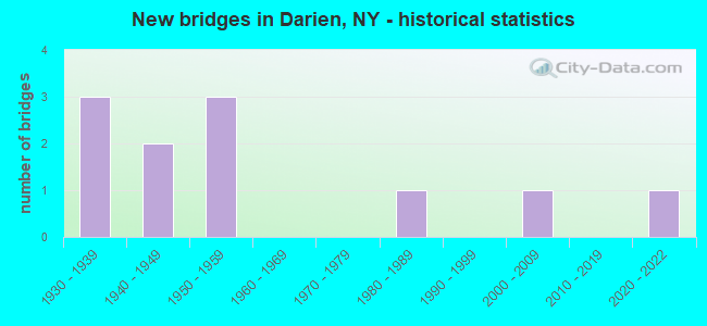
- New bridges - historical statistics
- 31930-1939
- 21940-1949
- 31950-1959
- 11980-1989
- 12000-2009
- 12020-2022

- Reconstructed bridges - Historical Statistics
- 11980-1989
- 11990-1999
- 22000-2009


- Bridge Condition - Deck
- 16.7%Excellent
- 16.7%Very good
- 16.7%Good
- 50.0%Satisfactory

- Bridge Condition - Superstructure
- 28.6%Excellent
- 71.4%Satisfactory

- Bridge Condition - Substructure
- 14.3%Excellent
- 14.3%Very good
- 14.3%Good
- 14.3%Satisfactory
- 28.6%Fair
- 14.3%Poor

- Bridge Condition - Channel
- 9.1%Excellent
- 36.4%Satisfactory
- 27.3%Fair
- 27.3%Poor

- Bridge Condition - Culverts
- 25.0%Very good
- 50.0%Satisfactory
- 25.0%Fair
Find on map >> Show street view
Structure Number: 101561, Location: 5.2 MI W JCT RTS 20 + 98 (Lat: 42.902003, Lng: -78.353844), Route carried "on" structure: US 20, Year Built: 1935, Status: Open, Structure Length: 0.98m (3.22ft), Average Daily Traffic: 6,824 (year 2018), Truck Traffic: 19%, Average Future Daily Traffic: 6,888 (year 2040), Features Intersected: MURDER CREEK
Minimum Vertical Clearance: 30+ m (98+ ft), Kilometerpoint: 8.978, Lanes on structure: 2, Base Highway Network: Yes, Owner: State Highway Agency, Approaching Roadway Width: 13.7m (44.9ft), Skew: 2 degrees, Material/Design: Concrete, Design/Construction: Frame, Number Of Spans In Main Unit: 1, Length of Maximum Span: 8.5m (27.9ft), Curb-To-Curb Width: 13.4m (44.0ft), Out-to-Out Width: 19.6m (64.3ft)
Condition: Deck: Satisfactory, Superstructure: Satisfactory, Substructure: Satisfactory, Channel: Satisfactory, Operating Rating: 76.2 metric tons, Method Used To Determine Operating Rating: Load Factor (LF), Inventory Rating: 45.4 metric tons, Method Used To Determine Inventory Rating: Load Factor (LF), Structural Evaluation: Equal to present minimum criteria, Deck Geometry: Equal to present minimum criteria, Waterway Adequacy: Equal to present minimum criteria, Approach Roadway Alignment: Equal to present desirable criteria, Length Of Structure Improvement: 0.97m (3.18ft), Designated Inspection Frequency: Every 24 months, Inspection Date: September 2020, Bridge Improvement Cost: $1,159,000, Roadway Improvement Cost: $678,000, Total Project Cost: $1,837,000 ( Estimate for 2021)
Find on map >> Show street view
Structure Number: 331537, Location: 2.6 MILES SW OF CORFU (Lat: 42.931231, Lng: -78.440125), Route carried "on" structure: County highway , Year Built: 2005, Status: Open, Structure Length: 2.10m (6.89ft), Average Daily Traffic: 726 (year 2017), Truck Traffic: 9%, Average Future Daily Traffic: 1,016 (year 2037), Design Load: HS 25 or greater, Features Intersected: ELLICOTT CREEK, Facility Carried by Structure: FARGO ROAD
Minimum Vertical Clearance: 30+ m (98+ ft), Kilometerpoint: 3.588, Lanes on structure: 2, Owner: County Highway Agency, Approaching Roadway Width: 7.3m (24.0ft), Skew: 3 degrees, Material/Design: Prestressed concrete, Design/Construction: Box Beam or Girders - Multiple, Number Of Spans In Main Unit: 1, Length of Maximum Span: 19.9m (65.3ft), Curb-To-Curb Width: 9.6m (31.5ft), Out-to-Out Width: 10.6m (34.8ft)
Condition: Deck: Good, Superstructure: Excellent, Substructure: Very good, Channel: Satisfactory, Inventory Rating: 85.3 metric tons, Method Used To Determine Inventory Rating: Load Factor (LF), Structural Evaluation: Equal to present desirable criteria, Deck Geometry: Equal to present minimum criteria, Waterway Adequacy: Equal to present desirable criteria, Approach Roadway Alignment: Equal to present desirable criteria, Length Of Structure Improvement: 2.10m (6.89ft), Designated Inspection Frequency: Every 24 months, Inspection Date: September 2021, Bridge Improvement Cost: $577,000, Roadway Improvement Cost: $338,000, Total Project Cost: $915,000 ( Estimate for 2021), Wearing Surface/Protective System: Wearing Surface: Integral Concrete
Find on map >> Show street view
Structure Number: 331548, Location: 3.2 MI SW WEST BATAVIA (Lat: 42.945881, Lng: -78.343136), Route carried "on" structure: Other road , Year Built: 1953, Status: Open, Structure Length: 1.04m (3.41ft), Average Daily Traffic: 285 (year 2017), Truck Traffic: 5%, Average Future Daily Traffic: 399 (year 2037), Features Intersected: MURDER CREEK, Facility Carried by Structure: RICHLEY ROAD
Minimum Vertical Clearance: 30+ m (98+ ft), Kilometerpoint: 3.250, Lanes on structure: 2, Owner: County Highway Agency, Approaching Roadway Width: 5.5m (18.0ft), Material/Design: Steel, Design/Construction: Culvert, Number Of Spans In Main Unit: 2, Length of Maximum Span: 4.8m (15.7ft)
Condition: Channel: Fair, Culverts: Fair, Operating Rating: 72.0 metric tons, Method Used To Determine Operating Rating: Field evaluation and documented engineering judgment, Inventory Rating: 19.6 metric tons, Method Used To Determine Inventory Rating: Field evaluation and documented engineering judgment, Structural Evaluation: Somewhat better than minimum adequacy, Waterway Adequacy: Better than present minimum criteria, Approach Roadway Alignment: Equal to present desirable criteria, Length Of Structure Improvement: 1.03m (3.38ft), Designated Inspection Frequency: Every 12 months, Inspection Date: April 2021, Bridge Improvement Cost: $102,000, Roadway Improvement Cost: $60,000, Total Project Cost: $161,000 ( Estimate for 2021)
Find on map >> Show street view
Structure Number: 33155, Location: 2.8 MILES SW OF CORFU (Lat: 42.922531, Lng: -78.424075), Route carried "on" structure: County highway , Year Built: 1934, Year Reconstructed: 1985, Status: Open, Structure Length: 1.19m (3.90ft), Average Daily Traffic: 1,135 (year 2020), Truck Traffic: 7%, Average Future Daily Traffic: 1,589 (year 2040), Design Load: H 15, Features Intersected: ELEVENMILE CREEK, Facility Carried by Structure: SUMNER ROAD
Minimum Vertical Clearance: 30+ m (98+ ft), Kilometerpoint: 3.234, Lanes on structure: 2, Owner: County Highway Agency, Approaching Roadway Width: 7.9m (25.9ft), Material/Design: Steel, Design/Construction: Stringer/Multi-beam, Number Of Spans In Main Unit: 1, Length of Maximum Span: 11.5m (37.7ft), Curb-To-Curb Width: 9.1m (29.9ft), Out-to-Out Width: 9.8m (32.2ft)
Condition: Deck: Satisfactory, Superstructure: Satisfactory, Substructure: Fair, Channel: Fair, Operating Rating: 38.2 metric tons, Method Used To Determine Operating Rating: Load and Resistance Factor Rating (LRFR) rating reported by rating factor(RF) method using HL-93 loadings, Inventory Rating: 29.5 metric tons, Method Used To Determine Inventory Rating: Load and Resistance Factor Rating (LRFR) rating reported by rating factor(RF) method using HL-93 loadings, Structural Evaluation: Somewhat better than minimum adequacy, Deck Geometry: Somewhat better than minimum adequacy, Waterway Adequacy: Better than present minimum criteria, Approach Roadway Alignment: Equal to present desirable criteria, Length Of Structure Improvement: 1.18m (3.87ft), Designated Inspection Frequency: Every 24 months, Inspection Date: April 2021, Bridge Improvement Cost: $541,000, Roadway Improvement Cost: $317,000, Total Project Cost: $858,000 ( Estimate for 2021), Deck Structure Type: Concrete Cast-file-Place, Wearing Surface/Protective System: Wearing Surface: Bituminous, Membrane: Other
Find on map >> Show street view
Structure Number: 331551, Location: 2.7 MI SOUTHEAST OF CORFU (Lat: 42.923203, Lng: -78.382486), Route carried "on" structure: County highway , Year Built: 1934, Status: Open, Structure Length: 0.85m (2.79ft), Average Daily Traffic: 1,447 (year 2020), Truck Traffic: 6%, Average Future Daily Traffic: 2,026 (year 2040), Features Intersected: CROOKED CREEK, Facility Carried by Structure: SUMNER ROAD
Minimum Vertical Clearance: 30+ m (98+ ft), Kilometerpoint: 6.645, Lanes on structure: 2, Owner: County Highway Agency, Approaching Roadway Width: 9.1m (29.9ft), Material/Design: Steel, Design/Construction: Culvert, Number Of Spans In Main Unit: 2, Length of Maximum Span: 3.9m (12.8ft)
Condition: Channel: Poor, Culverts: Satisfactory, Operating Rating: 72.5 metric tons, Method Used To Determine Operating Rating: Field evaluation and documented engineering judgment, Inventory Rating: 29.4 metric tons, Method Used To Determine Inventory Rating: Field evaluation and documented engineering judgment, Structural Evaluation: Equal to present minimum criteria, Waterway Adequacy: Better than present minimum criteria, Approach Roadway Alignment: Equal to present desirable criteria, Length Of Structure Improvement: 0.85m (2.79ft), Designated Inspection Frequency: Every 24 months, Inspection Date: May 2021, Bridge Improvement Cost: $140,000, Roadway Improvement Cost: $82,000, Total Project Cost: $222,000 ( Estimate for 2021)
Find on map >> Show street view
Structure Number: 331552, Location: 2.7 MI NE DARIEN CENTER (Lat: 42.923678, Lng: -78.346169), Route carried "on" structure: County highway , Year Built: 1988, Status: Open, Structure Length: 0.98m (3.22ft), Average Daily Traffic: 791 (year 2020), Truck Traffic: 7%, Average Future Daily Traffic: 1,107 (year 2040), Design Load: HS 20, Features Intersected: MURDER CREEK, Facility Carried by Structure: SUMNER ROAD
Minimum Vertical Clearance: 30+ m (98+ ft), Kilometerpoint: 9.654, Lanes on structure: 2, Owner: County Highway Agency, Approaching Roadway Width: 6.7m (22.0ft), Material/Design: Concrete, Design/Construction: Frame, Number Of Spans In Main Unit: 1, Length of Maximum Span: 9.1m (29.9ft), Curb-To-Curb Width: 10.2m (33.5ft), Out-to-Out Width: 10.8m (35.4ft)
Condition: Superstructure: Satisfactory, Substructure: Good, Channel: Satisfactory, Operating Rating: 78.4 metric tons, Method Used To Determine Operating Rating: Field evaluation and documented engineering judgment, Inventory Rating: 29.4 metric tons, Method Used To Determine Inventory Rating: Field evaluation and documented engineering judgment, Structural Evaluation: Equal to present minimum criteria, Deck Geometry: Equal to present minimum criteria, Waterway Adequacy: Equal to present desirable criteria, Approach Roadway Alignment: Equal to present desirable criteria, Length Of Structure Improvement: 0.97m (3.18ft), Designated Inspection Frequency: Every 24 months, Inspection Date: April 2021, Bridge Improvement Cost: $377,000, Roadway Improvement Cost: $221,000, Total Project Cost: $598,000 ( Estimate for 2021)
Find on map >> Show street view
Structure Number: 331555, Location: 1.2 MI SW DARIEN CENTER (Lat: 42.891242, Lng: -78.407142), Route carried "on" structure: Other road , Year Built: 1959, Year Reconstructed: 1999, Status: Open, Structure Length: 1.16m (3.81ft), Average Daily Traffic: 179 (year 2017), Truck Traffic: 7%, Average Future Daily Traffic: 251 (year 2037), Design Load: HS 25 or greater, Features Intersected: ELEVENMILE CREEK, Facility Carried by Structure: HERKIMER ROAD
Minimum Vertical Clearance: 30+ m (98+ ft), Kilometerpoint: 0.129, Lanes on structure: 2, Owner: County Highway Agency, Approaching Roadway Width: 6.1m (20.0ft), Skew: 4 degrees, Material/Design: Aluminum, Iron, Design/Construction: Culvert, Number Of Spans In Main Unit: 2, Length of Maximum Span: 5.4m (17.7ft)
Condition: Channel: Poor, Culverts: Very good, Operating Rating: 89.8 metric tons, Method Used To Determine Operating Rating: Load Factor (LF), Inventory Rating: 89.8 metric tons, Method Used To Determine Inventory Rating: Load Factor (LF), Structural Evaluation: Equal to present desirable criteria, Waterway Adequacy: Meets minimum limits, Approach Roadway Alignment: Equal to present desirable criteria, Length Of Structure Improvement: 1.15m (3.77ft), Designated Inspection Frequency: Every 24 months, Inspection Date: September 2020, Bridge Improvement Cost: $127,000, Roadway Improvement Cost: $74,000, Total Project Cost: $201,000 ( Estimate for 2021)
Find on map >> Show street view
Structure Number: 331556, Location: 2.2 MI NE DARIEN CENTER (Lat: 42.920958, Lng: -78.353972), Route carried "on" structure: Other road , Year Built: 1947, Year Reconstructed: 2000, Status: Open, Structure Length: 1.22m (4.00ft), Average Daily Traffic: 445 (year 2017), Truck Traffic: 10%, Average Future Daily Traffic: 623 (year 2037), Features Intersected: MURDER CREEK, Facility Carried by Structure: HARPER ROAD
Minimum Vertical Clearance: 30+ m (98+ ft), Kilometerpoint: 2.767, Lanes on structure: 2, Owner: County Highway Agency, Approaching Roadway Width: 6.4m (21.0ft), Material/Design: Steel, Design/Construction: Stringer/Multi-beam, Number Of Spans In Main Unit: 1, Length of Maximum Span: 11.5m (37.7ft), Curb-To-Curb Width: 8.2m (26.9ft), Out-to-Out Width: 9.1m (29.9ft)
Condition: Deck: Very good, Superstructure: Satisfactory, Substructure: Poor, Channel: Fair, Operating Rating: 60.8 metric tons, Method Used To Determine Operating Rating: Load Factor (LF), Inventory Rating: 36.3 metric tons, Method Used To Determine Inventory Rating: Load Factor (LF), Structural Evaluation: Meets minimum limits, Deck Geometry: Somewhat better than minimum adequacy, Waterway Adequacy: Better than present minimum criteria, Approach Roadway Alignment: Equal to present desirable criteria, Length Of Structure Improvement: 1.21m (3.97ft), Designated Inspection Frequency: Every 24 months, Inspection Date: May 2021, Bridge Improvement Cost: $440,000, Roadway Improvement Cost: $258,000, Total Project Cost: $698,000 ( Estimate for 2021), Deck Structure Type: Open Grating, Wearing Surface/Protective System: Wearing Surface: Other
Find on map >> Show street view
Structure Number: 331557, Location: 1.6 MI NE DARIEN CENTER (Lat: 42.909950, Lng: -78.359031), Route carried "on" structure: Other road , Year Built: 2021, Status: Open, Structure Length: 1.30m (4.27ft), Average Daily Traffic: 95 (year 2017), Truck Traffic: 5%, Average Future Daily Traffic: 133 (year 2037), Design Load: HS 25 or greater, Features Intersected: MURDER CREEK, Facility Carried by Structure: SHARRICK ROAD
Minimum Vertical Clearance: 30+ m (98+ ft), Kilometerpoint: 0.756, Lanes on structure: 2, Owner: County Highway Agency, Approaching Roadway Width: 7.9m (25.9ft), Skew: 2 degrees, Material/Design: Concrete, Design/Construction: Frame, Number Of Spans In Main Unit: 1, Length of Maximum Span: 12.2m (40.0ft), Curb-To-Curb Width: 8.0m (26.2ft), Out-to-Out Width: 9.1m (29.9ft)
Condition: Deck: Excellent, Superstructure: Excellent, Substructure: Excellent, Channel: Excellent, Inventory Rating: 63.5 metric tons, Method Used To Determine Inventory Rating: Load Factor (LF), Structural Evaluation: Superior to present desirable criteria, Deck Geometry: Equal to present minimum criteria, Waterway Adequacy: Superior to present desirable criteria, Approach Roadway Alignment: Equal to present desirable criteria, Length Of Structure Improvement: 1.09m (3.58ft), Designated Inspection Frequency: Every 24 months, Inspection Date: December 2021, Bridge Improvement Cost: $365,000, Roadway Improvement Cost: $214,000, Total Project Cost: $578,000 ( Estimate for 2021), Wearing Surface/Protective System: Wearing Surface: Bituminous, Membrane: Other
Find on map >> Show street view
Structure Number: 331558, Location: 2.2 MI SE DARIEN CENTER (Lat: 42.894106, Lng: -78.346967), Route carried "on" structure: Other road , Year Built: 1954, Year Reconstructed: 2007, Status: Open, Structure Length: 0.91m (2.99ft), Average Daily Traffic: 140 (year 2017), Truck Traffic: 5%, Average Future Daily Traffic: 196 (year 2037), Design Load: H 20, Features Intersected: MURDER CREEK, Facility Carried by Structure: GRISWOLD ROAD
Minimum Vertical Clearance: 30+ m (98+ ft), Kilometerpoint: 0.322, Lanes on structure: 2, Owner: County Highway Agency, Approaching Roadway Width: 6.7m (22.0ft), Material/Design: Steel, Design/Construction: Culvert, Number Of Spans In Main Unit: 2, Length of Maximum Span: 3.9m (12.8ft), Curb-To-Curb Width: 10.3m (33.8ft), Out-to-Out Width: 12.3m (40.4ft)
Condition: Channel: Satisfactory, Culverts: Satisfactory, Operating Rating: 72.8 metric tons, Method Used To Determine Operating Rating: Field evaluation and documented engineering judgment, Inventory Rating: 32.7 metric tons, Method Used To Determine Inventory Rating: Field evaluation and documented engineering judgment, Structural Evaluation: Equal to present minimum criteria, Deck Geometry: Better than present minimum criteria, Waterway Adequacy: Better than present minimum criteria, Approach Roadway Alignment: Equal to present desirable criteria, Length Of Structure Improvement: 0.91m (2.99ft), Designated Inspection Frequency: Every 24 months, Inspection Date: April 2021, Bridge Improvement Cost: $202,000, Roadway Improvement Cost: $118,000, Total Project Cost: $319,000 ( Estimate for 2021)
Find on map >> Show street view
Structure Number: 331559, Location: 2.3 MI SE OF DARIEN CENTR (Lat: 42.892117, Lng: -78.345633), Route carried "on" structure: Other road , Year Built: 1949, Status: Posted for load, Structure Length: 1.01m (3.31ft), Average Daily Traffic: 140 (year 2017), Truck Traffic: 5%, Average Future Daily Traffic: 196 (year 2037), Design Load: H 15, Features Intersected: MURDER CREEK, Facility Carried by Structure: GRISWOLD ROAD
Minimum Vertical Clearance: 30+ m (98+ ft), Kilometerpoint: 0.563, Lanes on structure: 2, Owner: County Highway Agency, Approaching Roadway Width: 6.1m (20.0ft), Material/Design: Steel, Design/Construction: Stringer/Multi-beam, Number Of Spans In Main Unit: 1, Length of Maximum Span: 9.1m (29.9ft), Curb-To-Curb Width: 8.7m (28.5ft), Out-to-Out Width: 9.1m (29.9ft)
Condition: Deck: Satisfactory, Superstructure: Satisfactory, Substructure: Fair, Channel: Poor, Operating Rating: 22.7 metric tons, Method Used To Determine Operating Rating: Field evaluation and documented engineering judgment, Inventory Rating: 22.7 metric tons, Method Used To Determine Inventory Rating: Field evaluation and documented engineering judgment, Structural Evaluation: Somewhat better than minimum adequacy, Deck Geometry: Equal to present minimum criteria, Waterway Adequacy: Equal to present desirable criteria, Approach Roadway Alignment: Better than present minimum criteria, Bridge Posting: Required (Relationship of Operating Rating to Maximum Legal Load: 30.0 - 39.9% below), Length Of Structure Improvement: 1.00m (3.28ft), Designated Inspection Frequency: Every 12 months, Inspection Date: April 2021, Bridge Improvement Cost: $379,000, Roadway Improvement Cost: $222,000, Total Project Cost: $601,000 ( Estimate for 2021), Deck Structure Type: Open Grating, Wearing Surface/Protective System: Wearing Surface: Other