Bridge Statistics for Coxsackie, New York (NY)
Condition, Traffic, Stress, Structural Evaluation, Project Costs
- National Bridge Inventory (NBI) Statistics
- 12Number of bridges
- 59ft / 17.7mTotal length
- $12,237,000Total costs
- 98,354Total average daily traffic
- 8,748Total average daily truck traffic
- National Bridge Inventory (NBI) Registered Bridges for Coxsackie
- No street view available for this location
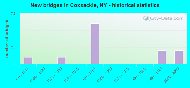
- New bridges - historical statistics
- 11910-1919
- 11930-1939
- 61950-1959
- 21990-1999
- 22000-2009

- Reconstructed bridges - Historical Statistics
- 11970-1979
- 11980-1989
- 01990-1999
- 12000-2009


- Bridge Condition - Deck
- 16.7%Very good
- 33.3%Good
- 33.3%Satisfactory
- 16.7%Fair

- Bridge Condition - Superstructure
- 14.3%Excellent
- 28.6%Very good
- 14.3%Good
- 42.9%Satisfactory

- Bridge Condition - Substructure
- 14.3%Excellent
- 42.9%Very good
- 14.3%Good
- 14.3%Satisfactory
- 14.3%Fair

- Bridge Condition - Channel
- 28.6%Good
- 28.6%Satisfactory
- 28.6%Fair
- 14.3%Poor
Find on map >> Show street view
Structure Number: 100751, Location: 1.0 MI S JCT RTS 9W & 81 (Lat: 42.349469, Lng: -73.841647), Route carried "on" structure: US 9W, Year Built: 1996, Status: Open, Structure Length: 1.34m (4.40ft), Average Daily Traffic: 6,335 (year 2019), Truck Traffic: 7%, Average Future Daily Traffic: 7,695 (year 2040), Design Load: HS 25 or greater, Features Intersected: COXSACKIE CREEK
Minimum Vertical Clearance: 30+ m (98+ ft), Kilometerpoint: 26.130, Lanes on structure: 3, Base Highway Network: Yes, Owner: State Highway Agency, Approaching Roadway Width: 14.6m (47.9ft), Skew: 2 degrees, Material/Design: Prestressed concrete, Design/Construction: Box Beam or Girders - Multiple, Number Of Spans In Main Unit: 1, Length of Maximum Span: 12.1m (39.7ft), Curb-To-Curb Width: 15.0m (49.2ft), Out-to-Out Width: 15.6m (51.2ft)
Condition: Deck: Satisfactory, Superstructure: Satisfactory, Substructure: Very good, Channel: Good, Operating Rating: 82.6 metric tons, Method Used To Determine Operating Rating: Load Factor (LF), Inventory Rating: 42.6 metric tons, Method Used To Determine Inventory Rating: Load Factor (LF), Structural Evaluation: Equal to present minimum criteria, Deck Geometry: Equal to present minimum criteria, Waterway Adequacy: Equal to present minimum criteria, Approach Roadway Alignment: Equal to present desirable criteria, Length Of Structure Improvement: 1.34m (4.40ft), Designated Inspection Frequency: Every 24 months, Inspection Date: May 2020, Bridge Improvement Cost: $1,069,000, Roadway Improvement Cost: $626,000, Total Project Cost: $1,696,000 ( Estimate for 2021), Deck Structure Type: Concrete Cast-file-Place, Wearing Surface/Protective System: Wearing Surface: Monolithic Concrete, Deck Protection: Epoxy Coated Reinforcing
Find on map >> Show street view
Structure Number: 100752, Location: 0.7 MI S JCT RTS 9W & 81 (Lat: 42.355278, Lng: -73.837711), Route carried "on" structure: US 9W, Year Built: 1996, Status: Open, Structure Length: 1.34m (4.40ft), Average Daily Traffic: 6,335 (year 2019), Truck Traffic: 7%, Average Future Daily Traffic: 7,695 (year 2040), Design Load: HS 25 or greater, Features Intersected: CLIMAX BROOK
Minimum Vertical Clearance: 30+ m (98+ ft), Kilometerpoint: 26.854, Lanes on structure: 2, Base Highway Network: Yes, Owner: State Highway Agency, Approaching Roadway Width: 11.3m (37.1ft), Skew: 2 degrees, Material/Design: Prestressed concrete, Design/Construction: Box Beam or Girders - Multiple, Number Of Spans In Main Unit: 1, Length of Maximum Span: 12.1m (39.7ft), Curb-To-Curb Width: 11.3m (37.1ft), Out-to-Out Width: 11.9m (39.0ft)
Condition: Deck: Good, Superstructure: Satisfactory, Substructure: Very good, Channel: Satisfactory, Operating Rating: 82.6 metric tons, Method Used To Determine Operating Rating: Load Factor (LF), Inventory Rating: 46.3 metric tons, Method Used To Determine Inventory Rating: Load Factor (LF), Structural Evaluation: Equal to present minimum criteria, Deck Geometry: Meets minimum limits, Waterway Adequacy: Equal to present minimum criteria, Approach Roadway Alignment: Equal to present desirable criteria, Length Of Structure Improvement: 1.34m (4.40ft), Designated Inspection Frequency: Every 24 months, Inspection Date: May 2020, Bridge Improvement Cost: $709,000, Roadway Improvement Cost: $415,000, Total Project Cost: $1,125,000 ( Estimate for 2021), Deck Structure Type: Concrete Cast-file-Place, Wearing Surface/Protective System: Wearing Surface: Monolithic Concrete, Deck Protection: Epoxy Coated Reinforcing
Find on map >> Show street view
Structure Number: 103106, Location: JCT RTE 81 & I87 (Lat: 42.365328, Lng: -73.846861), Route carried "on" structure: State highway 81, Year Built: 1955, Year Reconstructed: 1991, Status: Open, Structure Length: 8.26m (27.10ft), Average Daily Traffic: 4,575 (year 2016), Truck Traffic: 6%, Average Future Daily Traffic: 4,772 (year 2040), Design Load: HS 20, Features Intersected: I-87 NB, RTE I87
Minimum Vertical Clearance: 30+ m (98+ ft), Kilometerpoint: 32.067, Lanes on structure: 2, Lanes under structure: 4, Base Highway Network: Yes, Owner: State Toll Authority, Approaching Roadway Width: 9.1m (29.9ft), Skew: 5 degrees, Material/Design: Steel, Design/Construction: Stringer/Multi-beam, Number Of Spans In Main Unit: 4, Length of Maximum Span: 22.9m (75.1ft), Curb-To-Curb Width: 9.1m (29.9ft), Out-to-Out Width: 10.1m (33.1ft)
Condition: Deck: Fair, Superstructure: Satisfactory, Substructure: Fair, Operating Rating: 56.2 metric tons, Method Used To Determine Operating Rating: Load Factor (LF), Inventory Rating: 33.6 metric tons, Method Used To Determine Inventory Rating: Load Factor (LF), Structural Evaluation: Somewhat better than minimum adequacy, Deck Geometry: Meets minimum limits, Underclear: High priority of corrective action, Approach Roadway Alignment: Equal to present desirable criteria, Length Of Structure Improvement: 8.26m (27.10ft), Designated Inspection Frequency: Every 24 months, Inspection Date: April 2020, Bridge Improvement Cost: $2,365,000, Roadway Improvement Cost: $1,385,000, Total Project Cost: $3,750,000 ( Estimate for 2021), Deck Structure Type: Concrete Cast-file-Place, Wearing Surface/Protective System: Wearing Surface: Integral Concrete, Deck Protection: Epoxy Coated Reinforcing
Find on map >> Show street view
Structure Number: 104739, Location: 0.3 MI E JCT RTS 9W & 385 (Lat: 42.362458, Lng: -73.829031), Route carried "on" structure: State highway 385, Year Built: 1952, Status: Open, Structure Length: 1.37m (4.49ft), Average Daily Traffic: 7,861 (year 2020), Truck Traffic: 4%, Average Future Daily Traffic: 8,200 (year 2040), Features Intersected: COXSACKIE CREEK
Minimum Vertical Clearance: 30+ m (98+ ft), Kilometerpoint: 21.898, Lanes on structure: 2, Base Highway Network: Yes, Owner: State Highway Agency, Approaching Roadway Width: 10.4m (34.1ft), Skew: 1 degrees, Material/Design: Concrete continuous, Design/Construction: Culvert, Number Of Spans In Main Unit: 2, Length of Maximum Span: 6.4m (21.0ft), Curb or Sidewalk Widths: Left: 1.5m (4.9ft), Right: 1.5m (4.9ft), Curb-To-Curb Width: 10.4m (34.1ft), Out-to-Out Width: 14.2m (46.6ft)
Condition: Channel: Satisfactory, Culverts: Satisfactory, Operating Rating: 73.8 metric tons, Method Used To Determine Operating Rating: Field evaluation and documented engineering judgment, Inventory Rating: 29.4 metric tons, Method Used To Determine Inventory Rating: Field evaluation and documented engineering judgment, Structural Evaluation: Equal to present minimum criteria, Deck Geometry: Meets minimum limits, Waterway Adequacy: Somewhat better than minimum adequacy, Approach Roadway Alignment: Equal to present desirable criteria, Length Of Structure Improvement: 1.37m (4.49ft), Designated Inspection Frequency: Every 24 months, Inspection Date: April 2020, Bridge Improvement Cost: $658,000, Roadway Improvement Cost: $385,000, Total Project Cost: $1,043,000 ( Estimate for 2021), Wearing Surface/Protective System: Wearing Surface: Bituminous
Find on map >> Show street view
Structure Number: 105361, Location: 0.3 MI W JCT I87 & RT 81 (Lat: 42.365531, Lng: -73.852567), Route carried "on" structure: State highway 81, Year Built: 1953, Year Reconstructed: 2005, Status: Open, Structure Length: 0.79m (2.59ft), Average Daily Traffic: 3,743 (year 2016), Truck Traffic: 5%, Average Future Daily Traffic: 3,904 (year 2040), Features Intersected: UNKNOWN CREEK
Minimum Vertical Clearance: 30+ m (98+ ft), Kilometerpoint: 31.633, Lanes on structure: 2, Base Highway Network: Yes, Owner: State Highway Agency, Approaching Roadway Width: 8.8m (28.9ft), Skew: 4 degrees, Material/Design: Concrete, Design/Construction: Culvert, Number Of Spans In Main Unit: 1, Length of Maximum Span: 6.0m (19.7ft)
Condition: Channel: Fair, Culverts: Satisfactory, Operating Rating: 62.2 metric tons, Method Used To Determine Operating Rating: Load and Resistance Factor Rating (LRFR) rating reported by rating factor(RF) method using HL-93 loadings, Inventory Rating: 48.0 metric tons, Method Used To Determine Inventory Rating: Load and Resistance Factor Rating (LRFR) rating reported by rating factor(RF) method using HL-93 loadings, Structural Evaluation: Equal to present minimum criteria, Waterway Adequacy: Somewhat better than minimum adequacy, Approach Roadway Alignment: Equal to present desirable criteria, Length Of Structure Improvement: 0.79m (2.59ft), Designated Inspection Frequency: Every 24 months, Inspection Date: May 2021, Bridge Improvement Cost: $419,000, Roadway Improvement Cost: $245,000, Total Project Cost: $664,000 ( Estimate for 2021)
Find on map >> Show street view
Structure Number: 220069, Location: 0.5 MI SW COXSACKIE (Lat: 42.346114, Lng: -73.846589), Route carried "on" structure: Other road , Year Built: 1910, Year Reconstructed: 1981, Status: Open, Structure Length: 0.88m (2.89ft), Average Daily Traffic: 450 (year 2016), Truck Traffic: 3%, Average Future Daily Traffic: 630 (year 2036), Features Intersected: COXSACKIE CREEK, Facility Carried by Structure: PETER BRONCK ROAD
Minimum Vertical Clearance: 30+ m (98+ ft), Kilometerpoint: 0.451, Lanes on structure: 2, Owner: Town or Township Highway Agency, Approaching Roadway Width: 5.5m (18.0ft), Skew: 1 degrees, Material/Design: Steel, Design/Construction: Stringer/Multi-beam, Number Of Spans In Main Unit: 1, Length of Maximum Span: 7.3m (24.0ft), Curb-To-Curb Width: 6.9m (22.6ft), Out-to-Out Width: 8.1m (26.6ft)
Condition: Deck: Satisfactory, Superstructure: Very good, Substructure: Satisfactory, Channel: Poor, Operating Rating: 53.5 metric tons, Method Used To Determine Operating Rating: Load Factor (LF), Inventory Rating: 31.8 metric tons, Method Used To Determine Inventory Rating: Load Factor (LF), Structural Evaluation: Equal to present minimum criteria, Deck Geometry: Meets minimum limits, Waterway Adequacy: Somewhat better than minimum adequacy, Approach Roadway Alignment: Equal to present minimum criteria, Length Of Structure Improvement: 0.88m (2.89ft), Designated Inspection Frequency: Every 24 months, Inspection Date: April 2021, Bridge Improvement Cost: $176,000, Roadway Improvement Cost: $103,000, Total Project Cost: $279,000 ( Estimate for 2021), Deck Structure Type: Concrete Cast-file-Place, Wearing Surface/Protective System: Wearing Surface: Bituminous
Find on map >> Show street view
Structure Number: 320079, Location: 1.5 MI S VILL COXSACKIE (Lat: 42.320783, Lng: -73.829828), Route carried "on" structure: Other road , Year Built: 2002, Status: Open, Structure Length: 1.04m (3.41ft), Average Daily Traffic: 425 (year 2019), Truck Traffic: 6%, Average Future Daily Traffic: 595 (year 2039), Design Load: HS 25 or greater, Features Intersected: MURDERERS CREEK, Facility Carried by Structure: FLATS ROAD
Minimum Vertical Clearance: 30+ m (98+ ft), Kilometerpoint: 1.673, Lanes on structure: 2, Owner: County Highway Agency, Approaching Roadway Width: 6.4m (21.0ft), Skew: 1 degrees, Material/Design: Steel, Design/Construction: Stringer/Multi-beam, Number Of Spans In Main Unit: 1, Length of Maximum Span: 9.4m (30.8ft), Curb-To-Curb Width: 6.4m (21.0ft), Out-to-Out Width: 7.0m (23.0ft)
Condition: Deck: Very good, Superstructure: Very good, Substructure: Very good, Channel: Fair, Operating Rating: 68.9 metric tons, Method Used To Determine Operating Rating: Load Factor (LF), Inventory Rating: 48.1 metric tons, Method Used To Determine Inventory Rating: Load Factor (LF), Structural Evaluation: Equal to present desirable criteria, Deck Geometry: High priority of corrective action, Waterway Adequacy: Somewhat better than minimum adequacy, Approach Roadway Alignment: Equal to present minimum criteria, Length Of Structure Improvement: 1.03m (3.38ft), Designated Inspection Frequency: Every 24 months, Inspection Date: July 2020, Bridge Improvement Cost: $240,000, Roadway Improvement Cost: $140,000, Total Project Cost: $380,000 ( Estimate for 2021), Deck Structure Type: Wood or Timber, Wearing Surface/Protective System: Wearing Surface: Bituminous
Find on map >> Show street view
Structure Number: 330316, Location: 2 MI S OF COXSACKIE (Lat: 42.321081, Lng: -73.820797), Route carried "on" structure: County highway , Year Built: 2003, Status: Open, Structure Length: 1.55m (5.09ft), Average Daily Traffic: 415 (year 2016), Truck Traffic: 5%, Average Future Daily Traffic: 581 (year 2036), Design Load: HS 25 or greater, Features Intersected: MURDERERS CREEK, Facility Carried by Structure: FARM TO MRKT ROAD
Minimum Vertical Clearance: 30+ m (98+ ft), Kilometerpoint: 5.245, Lanes on structure: 2, Owner: County Highway Agency, Approaching Roadway Width: 7.3m (24.0ft), Skew: 3 degrees, Material/Design: Prestressed concrete, Design/Construction: Box Beam or Girders - Multiple, Number Of Spans In Main Unit: 1, Length of Maximum Span: 14.9m (48.9ft), Curb-To-Curb Width: 7.3m (24.0ft), Out-to-Out Width: 8.2m (26.9ft)
Condition: Deck: Good, Superstructure: Excellent, Substructure: Excellent, Channel: Good, Operating Rating: 89.8 metric tons, Method Used To Determine Operating Rating: Load Factor (LF), Inventory Rating: 49.9 metric tons, Method Used To Determine Inventory Rating: Load Factor (LF), Structural Evaluation: Superior to present desirable criteria, Deck Geometry: Meets minimum limits, Waterway Adequacy: Meets minimum limits, Approach Roadway Alignment: Equal to present minimum criteria, Length Of Structure Improvement: 1.55m (5.09ft), Designated Inspection Frequency: Every 24 months, Inspection Date: October 2020, Bridge Improvement Cost: $425,000, Roadway Improvement Cost: $249,000, Total Project Cost: $674,000 ( Estimate for 2021), Deck Structure Type: Concrete Cast-file-Place, Wearing Surface/Protective System: Wearing Surface: Integral Concrete, Deck Protection: Epoxy Coated Reinforcing
Find on map >> Show street view
Structure Number: 5513269, Location: 1 MI W VILLAGE COXSACKIE (Lat: 42.351764, Lng: -73.852400), Route carried "on" structure: Interstate 87, Year Built: 1955, Status: Open, Structure Length: 1.13m (3.71ft), Average Daily Traffic: 26,034 (year 2020), Truck Traffic: 27%, Average Future Daily Traffic: 31,006 (year 2040), Design Load: HS 20+Mod, Features Intersected: Plank Road
Minimum Vertical Clearance: 30+ m (98+ ft), Kilometerpoint: 24.779, Lanes on structure: 4, Lanes under structure: 2, Base Highway Network: Yes, Toll: On Interstate toll segment, Owner: State Toll Authority, Approaching Roadway Width: 24.2m (79.4ft), Skew: 30 degrees, Material/Design: Concrete, Design/Construction: Arch - Deck, Number Of Spans In Main Unit: 1, Length of Maximum Span: 11.0m (36.1ft), Curb-To-Curb Width: 24.2m (79.4ft), Out-to-Out Width: 76.9m (252.3ft)
Condition: Superstructure: Good, Substructure: Good, Operating Rating: 80.4 metric tons, Method Used To Determine Operating Rating: Field evaluation and documented engineering judgment, Inventory Rating: 32.7 metric tons, Method Used To Determine Inventory Rating: Field evaluation and documented engineering judgment, Structural Evaluation: Better than present minimum criteria, Deck Geometry: Superior to present desirable criteria, Underclear: High priority of corrective action, Approach Roadway Alignment: Equal to present desirable criteria, Length Of Structure Improvement: 1.12m (3.67ft), Designated Inspection Frequency: Every 24 months, Inspection Date: June 2021, Bridge Improvement Cost: $1,656,000, Roadway Improvement Cost: $970,000, Total Project Cost: $2,626,000 ( Estimate for 2021)
Find on map >> Show street view
Structure Number: 103106, Location: JCT RTE 81 & I87 (Lat: 42.365328, Lng: -73.846861), Route carried "under" structure: Interstate 87, Year Built: 1955, Structure Length: 0. m, Average Daily Traffic: 34,543 (year 2014), Features Intersected: I-87 NB, RTE I87, Facility Carried by Structure: RTE 81
Minimum Vertical Clearance: 5.77m (18.93ft), Kilometerpoint: 196.636, Lanes on structure: 2, Lanes under structure: 2, Toll: On Interstate toll segment, Material/Design: Steel, Design/Construction: Stringer/Multi-beam, Length of Maximum Span: 22.9m (75.1ft)
Find on map >> Show street view
Structure Number: 5513269, Location: 1 MI W VILLAGE COXSACKIE (Lat: 42.351764, Lng: -73.852400), Route carried "under" structure: County highway , Year Built: 1955, Structure Length: 0. m, Average Daily Traffic: 50 (year 2021), Features Intersected: Plank Road, Facility Carried by Structure: RTE I87
Minimum Vertical Clearance: 7.65m (25.10ft), Kilometerpoint: 0.000, Lanes on structure: 4, Lanes under structure: 2, Material/Design: Concrete, Design/Construction: Arch - Deck, Length of Maximum Span: 11.0m (36.1ft)
Find on map >> Show street view
Structure Number: 704738, Location: W of JCT Rt 385 & CR 61 (Lat: 42.360128, Lng: -73.816094), Route carried "under" structure: State highway 385, Year Built: 1930, Structure Length: 0. m, Average Daily Traffic: 7,588 (year 2002), Features Intersected: RTE 385, Facility Carried by Structure: CSX TRANSPRTATION
Minimum Vertical Clearance: 4.22m (13.85ft), Kilometerpoint: 20.917, Lanes under structure: 2, Material/Design: Steel, Design/Construction: Girder and Floorbeam System, Length of Maximum Span: 12.1m (39.7ft)