Bridge Statistics for Chino Hills, California (CA)
Condition, Traffic, Stress, Structural Evaluation, Project Costs
- National Bridge Inventory (NBI) Statistics
- 42Number of bridges
- 633ft / 193mTotal length
- 1,554,001Total average daily traffic
- 146,452Total average daily truck traffic
- National Bridge Inventory (NBI) Registered Bridges for Chino Hills
- No street view available for this location
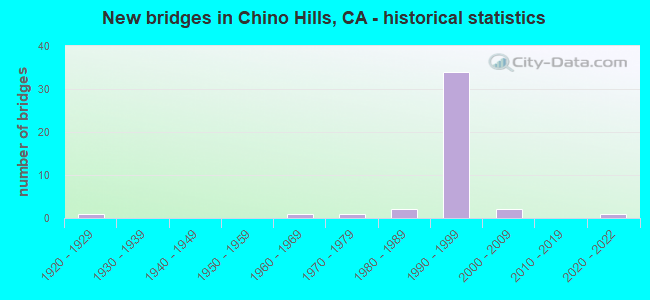
- New bridges - historical statistics
- 11920-1929
- 11960-1969
- 11970-1979
- 21980-1989
- 341990-1999
- 22000-2009
- 12020-2022

- Reconstructed bridges - Historical Statistics
- 11980-1989
- 21990-1999


- Bridge Condition - Deck
- 75.0%Good
- 25.0%Fair

- Bridge Condition - Superstructure
- 95.0%Good
- 5.0%Fair

- Bridge Condition - Channel
- 46.7%Excellent
- 40.0%Very good
- 6.7%Good
- 6.7%Satisfactory

- Bridge Condition - Culverts
- 77.8%Good
- 22.2%Satisfactory
Find on map >> Show street view
Structure Number: 54 01, Location: 08-SBD-142-0.18 (Lat: 33.947031, Lng: -117.779717), Route carried "on" structure: State highway 142, Year Built: 1928, Status: Open, Structure Length: 1.01m (3.31ft), Average Daily Traffic: 13,600 (year 2020), Truck Traffic: 1%, Average Future Daily Traffic: 20,403 (year 2041), Design Load: HS 15, Features Intersected: CARBON CANYON
Minimum Vertical Clearance: 30+ m (98+ ft), Kilometerpoint: 0.180, Lanes on structure: 2, Base Highway Network: Yes (Inventory Route: 1, Subroute: 1), Owner: State Highway Agency, Approaching Roadway Width: 7.4m (24.3ft), Skew: 4 degrees, Material/Design: Steel, Design/Construction: Stringer/Multi-beam, Number Of Spans In Main Unit: 1, Length of Maximum Span: 9.4m (30.8ft), Curb-To-Curb Width: 7.4m (24.3ft), Out-to-Out Width: 8.5m (27.9ft)
Condition: Deck: Good, Superstructure: Good, Substructure: Good, Channel: Good, Operating Rating: 43.4 metric tons, Method Used To Determine Operating Rating: Load Factor (LF), Inventory Rating: 25.9 metric tons, Method Used To Determine Inventory Rating: Load Factor (LF), Structural Evaluation: Equal to present minimum criteria, Deck Geometry: High priority of replacement, Waterway Adequacy: Better than present minimum criteria, Approach Roadway Alignment: Somewhat better than minimum adequacy, Designated Inspection Frequency: Every 24 months, Inspection Date: November 2021, Deck Structure Type: Concrete Cast-file-Place, Wearing Surface/Protective System: Wearing Surface: Bituminous
Find on map >> Show street view
Structure Number: 54 1096, Location: 08-SBD-071-R5.66-CHNH (Lat: 33.957431, Lng: -117.681606), Route carried "on" structure: State highway 71, Year Built: 1987, Status: Open, Structure Length: 1.55m (5.09ft), Average Daily Traffic: 73,000 (year 2014), Truck Traffic: 10%, Average Future Daily Traffic: 81,613 (year 2041), Features Intersected: LOWER LOS SERRANOS CHANL
Minimum Vertical Clearance: 30+ m (98+ ft), Kilometerpoint: 5.660, Lanes on structure: 9, Base Highway Network: Yes (, Subroute: 1), Owner: State Highway Agency, Approaching Roadway Width: 18.6m (61.0ft), Skew: 34 degrees, Material/Design: Concrete, Design/Construction: Culvert, Number Of Spans In Main Unit: 3, Length of Maximum Span: 4.9m (16.1ft), Curb-To-Curb Width: 35.2m (115.5ft), Out-to-Out Width: 86.3m (283.1ft)
Condition: Channel: Very good, Culverts: Good, Operating Rating: 54.1 metric tons, Method Used To Determine Operating Rating: Field evaluation and documented engineering judgment, Inventory Rating: 32.4 metric tons, Method Used To Determine Inventory Rating: Field evaluation and documented engineering judgment, Structural Evaluation: Better than present minimum criteria, Deck Geometry: Meets minimum limits, Waterway Adequacy: Equal to present desirable criteria, Approach Roadway Alignment: Equal to present desirable criteria, Designated Inspection Frequency: Every 48 months, Inspection Date: December 2019
Find on map >> Show street view
Structure Number: 54 1100G, Location: 08-SBD-210-R28.66-SBD (Lat: 34.129914, Lng: -117.205758), Route carried "on" structure: Ramp State highway 210, Year Built: 1992, Status: Open, Structure Length: 14.84m (48.69ft), Average Daily Traffic: 5,001 (year 2019), Truck Traffic: 3%, Average Future Daily Traffic: 6,121 (year 2041), Design Load: HS 20+Mod, Features Intersected: STATE ROUTE 210
Minimum Vertical Clearance: 30+ m (98+ ft), Kilometerpoint: 28.660, Lanes on structure: 2, Lanes under structure: 4, Owner: State Highway Agency, Approaching Roadway Width: 10.4m (34.1ft), Material/Design: Prestressed concrete continuous, Design/Construction: Box Beam or Girders - Multiple, Number Of Spans In Main Unit: 3, Length of Maximum Span: 52.7m (172.9ft), Curb-To-Curb Width: 10.4m (34.1ft), Out-to-Out Width: 11.4m (37.4ft)
Condition: Deck: Good, Superstructure: Fair, Substructure: Good, Operating Rating: 54.1 metric tons, Method Used To Determine Operating Rating: Assigned rating based on Load Factor Design (LFD) reported in metric tons, Inventory Rating: 32.4 metric tons, Method Used To Determine Inventory Rating: Assigned rating based on Load Factor Design (LFD) reported in metric tons, Structural Evaluation: Somewhat better than minimum adequacy, Deck Geometry: Better than present minimum criteria, Underclear: Meets minimum limits, Approach Roadway Alignment: Meets minimum limits, Designated Inspection Frequency: Every 24 months, Inspection Date: December 2021, Deck Structure Type: Concrete Cast-file-Place
Find on map >> Show street view
Structure Number: 54 1102F, Location: 08-SBD-071-R0.13-CHNH (Lat: 34.018836, Lng: -117.743389), Route carried "on" structure: Ramp State highway 71, Year Built: 1997, Status: Open, Structure Length: 5.80m (19.03ft), Average Daily Traffic: 4,000 (year 2020), Truck Traffic: 10%, Average Future Daily Traffic: 5,000 (year 2040), Design Load: HS 20+Mod, Features Intersected: PEYTON DRIVE
Minimum Vertical Clearance: 30+ m (98+ ft), Kilometerpoint: 0.130, Lanes on structure: 2, Lanes under structure: 8, Owner: State Highway Agency, Approaching Roadway Width: 12.0m (39.4ft), Skew: 2 degrees, Material/Design: Prestressed concrete, Design/Construction: Box Beam or Girders - Single/Spread, Number Of Spans In Main Unit: 1, Length of Maximum Span: 58.0m (190.3ft), Curb-To-Curb Width: 12.0m (39.4ft), Out-to-Out Width: 13.0m (42.7ft)
Condition: Deck: Good, Superstructure: Good, Substructure: Good, Operating Rating: 54.1 metric tons, Method Used To Determine Operating Rating: Assigned rating based on Load Factor Design (LFD) reported in metric tons, Inventory Rating: 32.4 metric tons, Method Used To Determine Inventory Rating: Assigned rating based on Load Factor Design (LFD) reported in metric tons, Structural Evaluation: Better than present minimum criteria, Deck Geometry: Superior to present desirable criteria, Underclear: Equal to present minimum criteria, Approach Roadway Alignment: Equal to present desirable criteria, Designated Inspection Frequency: Every 24 months, Inspection Date: November 2021, Deck Structure Type: Concrete Cast-file-Place
Find on map >> Show street view
Structure Number: 54 1103L, Location: 08-SBD-071-R0.14-CHNH (Lat: 34.018756, Lng: -117.743992), Route carried "on" structure: State highway 71, Year Built: 1997, Status: Open, Structure Length: 6.40m (21.00ft), Average Daily Traffic: 50,500 (year 2020), Truck Traffic: 10%, Average Future Daily Traffic: 69,000 (year 2040), Design Load: HS 20+Mod, Features Intersected: PEYTON DRIVE
Minimum Vertical Clearance: 30+ m (98+ ft), Kilometerpoint: 0.140, Lanes on structure: 2, Lanes under structure: 8, Base Highway Network: Yes (, Subroute: 1), Owner: State Highway Agency, Approaching Roadway Width: 16.0m (52.5ft), Skew: 3 degrees, Material/Design: Concrete, Design/Construction: Box Beam or Girders - Multiple, Number Of Spans In Main Unit: 1, Length of Maximum Span: 64.0m (210.0ft), Curb-To-Curb Width: 16.5m (54.1ft), Out-to-Out Width: 17.5m (57.4ft)
Condition: Deck: Good, Superstructure: Good, Substructure: Good, Operating Rating: 54.1 metric tons, Method Used To Determine Operating Rating: Assigned rating based on Load Factor Design (LFD) reported in metric tons, Inventory Rating: 32.4 metric tons, Method Used To Determine Inventory Rating: Assigned rating based on Load Factor Design (LFD) reported in metric tons, Structural Evaluation: Better than present minimum criteria, Deck Geometry: Superior to present desirable criteria, Underclear: Equal to present minimum criteria, Approach Roadway Alignment: Equal to present desirable criteria, Designated Inspection Frequency: Every 24 months, Inspection Date: November 2021, Deck Structure Type: Concrete Cast-file-Place
Find on map >> Show street view
Structure Number: 54 1103R, Location: 08-SBD-071-R0.13-CHNH (Lat: 34.018633, Lng: -117.744497), Route carried "on" structure: State highway 71, Year Built: 1996, Status: Open, Structure Length: 6.60m (21.65ft), Average Daily Traffic: 50,500 (year 2020), Truck Traffic: 10%, Average Future Daily Traffic: 69,000 (year 2040), Design Load: HS 20+Mod, Features Intersected: PEYTON DRIVE
Minimum Vertical Clearance: 30+ m (98+ ft), Kilometerpoint: 0.130, Lanes on structure: 4, Lanes under structure: 6, Base Highway Network: Yes (, Subroute: 1), Owner: State Highway Agency, Approaching Roadway Width: 24.0m (78.7ft), Skew: 3 degrees, Material/Design: Concrete, Design/Construction: Box Beam or Girders - Multiple, Number Of Spans In Main Unit: 1, Length of Maximum Span: 66.0m (216.5ft), Curb-To-Curb Width: 24.0m (78.7ft), Out-to-Out Width: 25.0m (82.0ft)
Condition: Deck: Fair, Superstructure: Good, Substructure: Good, Operating Rating: 54.1 metric tons, Method Used To Determine Operating Rating: Assigned rating based on Load Factor Design (LFD) reported in metric tons, Inventory Rating: 32.4 metric tons, Method Used To Determine Inventory Rating: Assigned rating based on Load Factor Design (LFD) reported in metric tons, Structural Evaluation: Better than present minimum criteria, Deck Geometry: Superior to present desirable criteria, Underclear: Equal to present minimum criteria, Approach Roadway Alignment: Equal to present desirable criteria, Designated Inspection Frequency: Every 24 months, Inspection Date: November 2021, Deck Structure Type: Concrete Cast-file-Place
Find on map >> Show street view
Structure Number: 54 1108F, Location: 08-SBD-071-R0.06-CHNH (Lat: 34.019842, Lng: -117.744450), Route carried "on" structure: Ramp State highway 71, Year Built: 1997, Status: Open, Structure Length: 4.10m (13.45ft), Average Daily Traffic: 4,000 (year 2020), Truck Traffic: 5%, Average Future Daily Traffic: 5,000 (year 2040), Design Load: HS 20+Mod, Features Intersected: GAREY AVE-NB 71 ON RAMP
Minimum Vertical Clearance: 30+ m (98+ ft), Kilometerpoint: 0.060, Lanes on structure: 2, Lanes under structure: 2, Owner: State Highway Agency, Approaching Roadway Width: 15.0m (49.2ft), Skew: 3 degrees, Material/Design: Concrete, Design/Construction: Box Beam or Girders - Multiple, Number Of Spans In Main Unit: 1, Length of Maximum Span: 41.0m (134.5ft), Curb-To-Curb Width: 15.0m (49.2ft), Out-to-Out Width: 16.0m (52.5ft)
Condition: Deck: Good, Superstructure: Good, Substructure: Good, Operating Rating: 54.1 metric tons, Method Used To Determine Operating Rating: Assigned rating based on Load Factor Design (LFD) reported in metric tons, Inventory Rating: 32.4 metric tons, Method Used To Determine Inventory Rating: Assigned rating based on Load Factor Design (LFD) reported in metric tons, Structural Evaluation: Better than present minimum criteria, Deck Geometry: Superior to present desirable criteria, Underclear: Equal to present minimum criteria, Approach Roadway Alignment: Equal to present desirable criteria, Designated Inspection Frequency: Every 24 months, Inspection Date: November 2021, Deck Structure Type: Concrete Cast-file-Place
Find on map >> Show street view
Structure Number: 54 112, Location: 08-SBD-058-R16.44 (Lat: 34.930989, Lng: -117.361456), Route carried "on" structure: State highway 58, Year Built: 1992, Status: Open, Structure Length: 0.76m (2.49ft), Average Daily Traffic: 12,000 (year 2019), Truck Traffic: 36%, Average Future Daily Traffic: 14,000 (year 2040), Features Intersected: ASTRID WASH
Minimum Vertical Clearance: 30+ m (98+ ft), Kilometerpoint: 16.440, Lanes on structure: 4, Base Highway Network: Yes (, Subroute: 1), Owner: State Highway Agency, Approaching Roadway Width: 23.8m (78.1ft), Skew: 20 degrees, Material/Design: Concrete continuous, Design/Construction: Culvert, Number Of Spans In Main Unit: 2, Length of Maximum Span: 3.7m (12.1ft)
Condition: Channel: Excellent, Culverts: Satisfactory, Operating Rating: 54.1 metric tons, Method Used To Determine Operating Rating: Field evaluation and documented engineering judgment, Inventory Rating: 32.4 metric tons, Method Used To Determine Inventory Rating: Field evaluation and documented engineering judgment, Structural Evaluation: Equal to present minimum criteria, Waterway Adequacy: Superior to present desirable criteria, Approach Roadway Alignment: Equal to present desirable criteria, Designated Inspection Frequency: Every 24 months, Inspection Date: April 2021
Find on map >> Show street view
Structure Number: 54 1126, Location: 08-SBD-071-R0.91-CHNH (Lat: 34.011444, Lng: -117.734047), Route carried "on" structure: State highway 71, Year Built: 1997, Status: Open, Structure Length: 7.70m (25.26ft), Average Daily Traffic: 101,000 (year 2020), Truck Traffic: 10%, Average Future Daily Traffic: 140,000 (year 2040), Design Load: HS 20+Mod, Features Intersected: CHINO AVENUE
Minimum Vertical Clearance: 30+ m (98+ ft), Kilometerpoint: 0.910, Lanes on structure: 8, Lanes under structure: 8, Base Highway Network: Yes (, Subroute: 1), Owner: State Highway Agency, Approaching Roadway Width: 44.0m (144.4ft), Skew: 32 degrees, Material/Design: Concrete continuous, Design/Construction: Box Beam or Girders - Multiple, Number Of Spans In Main Unit: 2, Length of Maximum Span: 42.0m (137.8ft), Curb-To-Curb Width: 44.0m (144.4ft), Out-to-Out Width: 45.6m (149.6ft)
Condition: Deck: Fair, Superstructure: Good, Substructure: Good, Operating Rating: 54.1 metric tons, Method Used To Determine Operating Rating: Assigned rating based on Load Factor Design (LFD) reported in metric tons, Inventory Rating: 32.4 metric tons, Method Used To Determine Inventory Rating: Assigned rating based on Load Factor Design (LFD) reported in metric tons, Structural Evaluation: Better than present minimum criteria, Deck Geometry: Superior to present desirable criteria, Underclear: Better than present minimum criteria, Approach Roadway Alignment: Equal to present desirable criteria, Designated Inspection Frequency: Every 24 months, Inspection Date: November 2021, Deck Structure Type: Concrete Cast-file-Place
Find on map >> Show street view
Structure Number: 54 1126K, Location: 08-SBD-071-R0.90-CHNH (Lat: 34.011581, Lng: -117.733492), Route carried "on" structure: Ramp State highway 71, Year Built: 1997, Status: Open, Structure Length: 7.80m (25.59ft), Average Daily Traffic: 4,500 (year 2020), Truck Traffic: 10%, Average Future Daily Traffic: 7,000 (year 2040), Design Load: HS 20+Mod, Features Intersected: CHINO AVENUE
Minimum Vertical Clearance: 30+ m (98+ ft), Kilometerpoint: 0.900, Lanes on structure: 2, Lanes under structure: 8, Base Highway Network: Yes, Owner: State Highway Agency, Approaching Roadway Width: 11.0m (36.1ft), Skew: 2 degrees, Material/Design: Concrete continuous, Design/Construction: Box Beam or Girders - Multiple, Number Of Spans In Main Unit: 2, Length of Maximum Span: 43.0m (141.1ft), Curb-To-Curb Width: 11.0m (36.1ft), Out-to-Out Width: 12.0m (39.4ft)
Condition: Deck: Good, Superstructure: Good, Substructure: Good, Operating Rating: 54.1 metric tons, Method Used To Determine Operating Rating: Assigned rating based on Load Factor Design (LFD) reported in metric tons, Inventory Rating: 32.4 metric tons, Method Used To Determine Inventory Rating: Assigned rating based on Load Factor Design (LFD) reported in metric tons, Structural Evaluation: Better than present minimum criteria, Deck Geometry: Better than present minimum criteria, Underclear: Better than present minimum criteria, Approach Roadway Alignment: Equal to present desirable criteria, Designated Inspection Frequency: Every 24 months, Inspection Date: November 2021, Deck Structure Type: Concrete Cast-file-Place
Find on map >> Show street view
Structure Number: 54 1127L, Location: 08-SBD-071-R1.40-CHNH (Lat: 34.007108, Lng: -117.729433), Route carried "on" structure: State highway 71, Year Built: 1997, Status: Open, Structure Length: 20.90m (68.57ft), Average Daily Traffic: 51,000 (year 2020), Truck Traffic: 10%, Average Future Daily Traffic: 64,000 (year 2040), Design Load: HS 20+Mod, Features Intersected: CHINO CREEK CHANNEL
Minimum Vertical Clearance: 30+ m (98+ ft), Kilometerpoint: 1.400, Lanes on structure: 5, Base Highway Network: Yes (, Subroute: 1), Owner: State Highway Agency, Approaching Roadway Width: 27.0m (88.6ft), Material/Design: Prestressed concrete continuous, Design/Construction: Box Beam or Girders - Multiple, Number Of Spans In Main Unit: 5, Length of Maximum Span: 53.0m (173.9ft), Curb-To-Curb Width: 27.6m (90.6ft), Out-to-Out Width: 28.7m (94.2ft)
Condition: Deck: Good, Superstructure: Good, Substructure: Good, Channel: Very good, Operating Rating: 54.1 metric tons, Method Used To Determine Operating Rating: Assigned rating based on Load Factor Design (LFD) reported in metric tons, Inventory Rating: 32.4 metric tons, Method Used To Determine Inventory Rating: Assigned rating based on Load Factor Design (LFD) reported in metric tons, Structural Evaluation: Better than present minimum criteria, Deck Geometry: Superior to present desirable criteria, Waterway Adequacy: Equal to present desirable criteria, Approach Roadway Alignment: Equal to present desirable criteria, Designated Inspection Frequency: Every 24 months, Inspection Date: November 2021, Deck Structure Type: Concrete Cast-file-Place
Find on map >> Show street view
Structure Number: 54 1127R, Location: 08-SBD-071-R1.40-CHNH (Lat: 34.006558, Lng: -117.729219), Route carried "on" structure: State highway 71, Year Built: 1997, Status: Open, Structure Length: 24.80m (81.36ft), Average Daily Traffic: 51,000 (year 2020), Truck Traffic: 10%, Average Future Daily Traffic: 64,000 (year 2040), Design Load: HS 20+Mod, Features Intersected: CHINO CREEK CHANNEL
Minimum Vertical Clearance: 30+ m (98+ ft), Kilometerpoint: 1.400, Lanes on structure: 5, Base Highway Network: Yes (, Subroute: 1), Owner: State Highway Agency, Approaching Roadway Width: 23.0m (75.5ft), Material/Design: Prestressed concrete continuous, Design/Construction: Box Beam or Girders - Multiple, Number Of Spans In Main Unit: 7, Length of Maximum Span: 52.0m (170.6ft), Curb-To-Curb Width: 23.9m (78.4ft), Out-to-Out Width: 24.9m (81.7ft)
Condition: Deck: Good, Superstructure: Good, Substructure: Good, Channel: Very good, Operating Rating: 54.1 metric tons, Method Used To Determine Operating Rating: Assigned rating based on Load Factor Design (LFD) reported in metric tons, Inventory Rating: 32.4 metric tons, Method Used To Determine Inventory Rating: Assigned rating based on Load Factor Design (LFD) reported in metric tons, Structural Evaluation: Better than present minimum criteria, Deck Geometry: Equal to present minimum criteria, Waterway Adequacy: Equal to present desirable criteria, Approach Roadway Alignment: Equal to present desirable criteria, Designated Inspection Frequency: Every 24 months, Inspection Date: November 2021, Deck Structure Type: Concrete Cast-file-Place
Find on map >> Show street view
Structure Number: 54 1128, Location: 08-SBD-071-R1.82-CHNH (Lat: 34.001028, Lng: -117.724361), Route carried "on" structure: State highway 71, Year Built: 1997, Status: Open, Structure Length: 7.30m (23.95ft), Average Daily Traffic: 105,000 (year 2020), Truck Traffic: 10%, Average Future Daily Traffic: 122,420 (year 2041), Design Load: HS 20+Mod, Features Intersected: GRAND AVENUE
Minimum Vertical Clearance: 30+ m (98+ ft), Kilometerpoint: 1.820, Lanes on structure: 9, Lanes under structure: 8, Base Highway Network: Yes (, Subroute: 1), Owner: State Highway Agency, Approaching Roadway Width: 50.0m (164.0ft), Skew: 33 degrees, Material/Design: Prestressed concrete continuous, Design/Construction: Box Beam or Girders - Multiple, Number Of Spans In Main Unit: 2, Length of Maximum Span: 42.0m (137.8ft), Curb-To-Curb Width: 50.1m (164.4ft), Out-to-Out Width: 51.7m (169.6ft)
Condition: Deck: Good, Superstructure: Good, Substructure: Good, Operating Rating: 54.1 metric tons, Method Used To Determine Operating Rating: Assigned rating based on Load Factor Design (LFD) reported in metric tons, Inventory Rating: 32.4 metric tons, Method Used To Determine Inventory Rating: Assigned rating based on Load Factor Design (LFD) reported in metric tons, Structural Evaluation: Better than present minimum criteria, Deck Geometry: Superior to present desirable criteria, Underclear: Somewhat better than minimum adequacy, Approach Roadway Alignment: Equal to present desirable criteria, Designated Inspection Frequency: Every 24 months, Inspection Date: November 2021, Deck Structure Type: Concrete Cast-file-Place
Find on map >> Show street view
Structure Number: 54 1129, Location: 08-SBD-071-R2.67-CHNH (Lat: 33.990417, Lng: -117.716753), Route carried "on" structure: State highway 71, Year Built: 1997, Status: Open, Structure Length: 28.00m (91.86ft), Average Daily Traffic: 91,000 (year 2020), Truck Traffic: 10%, Average Future Daily Traffic: 122,420 (year 2041), Design Load: HS 20+Mod, Features Intersected: PIPELINE AVE,CHINO CREEK
Minimum Vertical Clearance: 30+ m (98+ ft), Kilometerpoint: 2.670, Lanes on structure: 8, Lanes under structure: 4, Base Highway Network: Yes (, Subroute: 1), Owner: State Highway Agency, Approaching Roadway Width: 44.0m (144.4ft), Skew: 31 degrees, Material/Design: Concrete continuous, Design/Construction: Box Beam or Girders - Multiple, Number Of Spans In Main Unit: 8, Length of Maximum Span: 40.0m (131.2ft), Curb-To-Curb Width: 44.0m (144.4ft), Out-to-Out Width: 45.6m (149.6ft)
Condition: Deck: Good, Superstructure: Good, Substructure: Good, Channel: Very good, Operating Rating: 54.1 metric tons, Method Used To Determine Operating Rating: Assigned rating based on Load Factor Design (LFD) reported in metric tons, Inventory Rating: 32.4 metric tons, Method Used To Determine Inventory Rating: Assigned rating based on Load Factor Design (LFD) reported in metric tons, Structural Evaluation: Better than present minimum criteria, Deck Geometry: Superior to present desirable criteria, Underclear: Meets minimum limits, Waterway Adequacy: Equal to present desirable criteria, Approach Roadway Alignment: Equal to present desirable criteria, Designated Inspection Frequency: Every 24 months, Inspection Date: November 2021, Deck Structure Type: Concrete Cast-file-Place
Find on map >> Show street view
Structure Number: 54 1131, Location: 08-SBD-071-R3.35-CHNH (Lat: 33.982828, Lng: -117.709386), Route carried "on" structure: State highway 71, Year Built: 1997, Status: Open, Structure Length: 7.80m (25.59ft), Average Daily Traffic: 88,000 (year 2020), Truck Traffic: 10%, Average Future Daily Traffic: 122,420 (year 2041), Design Load: HS 20+Mod, Features Intersected: CHINO HILLS PARKWAY
Minimum Vertical Clearance: 30+ m (98+ ft), Kilometerpoint: 3.350, Lanes on structure: 8, Lanes under structure: 7, Base Highway Network: Yes (, Subroute: 1), Owner: State Highway Agency, Approaching Roadway Width: 44.0m (144.4ft), Skew: 34 degrees, Material/Design: Prestressed concrete continuous, Design/Construction: Box Beam or Girders - Multiple, Number Of Spans In Main Unit: 2, Length of Maximum Span: 42.0m (137.8ft), Curb-To-Curb Width: 44.0m (144.4ft), Out-to-Out Width: 45.6m (149.6ft)
Condition: Deck: Good, Superstructure: Good, Substructure: Good, Operating Rating: 54.1 metric tons, Method Used To Determine Operating Rating: Assigned rating based on Load Factor Design (LFD) reported in metric tons, Inventory Rating: 32.4 metric tons, Method Used To Determine Inventory Rating: Assigned rating based on Load Factor Design (LFD) reported in metric tons, Structural Evaluation: Better than present minimum criteria, Deck Geometry: Superior to present desirable criteria, Underclear: Better than present minimum criteria, Approach Roadway Alignment: Equal to present desirable criteria, Designated Inspection Frequency: Every 24 months, Inspection Date: November 2021, Deck Structure Type: Concrete Cast-file-Place
Find on map >> Show street view
Structure Number: 54 1132, Location: 08-SBD-071-R4.93-CHNH (Lat: 33.968492, Lng: -117.689586), Route carried "on" structure: City street , Year Built: 1997, Status: Open, Structure Length: 10.50m (34.45ft), Average Daily Traffic: 15,000 (year 2020), Truck Traffic: 1%, Average Future Daily Traffic: 20,403 (year 2041), Design Load: HS 20+Mod, Features Intersected: STATE ROUTE 71, Facility Carried by Structure: SOQUEL CANYON PKWY
Minimum Vertical Clearance: 30+ m (98+ ft), Kilometerpoint: 0.000, Lanes on structure: 6, Lanes under structure: 10, Base Highway Network: Yes, Owner: State Highway Agency, Approaching Roadway Width: 30.6m (100.4ft), Skew: 12 degrees, Material/Design: Prestressed concrete continuous, Design/Construction: Box Beam or Girders - Multiple, Number Of Spans In Main Unit: 2, Length of Maximum Span: 53.0m (173.9ft), Curb or Sidewalk Widths: Left: 1.5m (4.9ft), Right: 1.5m (4.9ft), Curb-To-Curb Width: 34.0m (111.5ft), Out-to-Out Width: 39.7m (130.2ft)
Condition: Deck: Good, Superstructure: Good, Substructure: Good, Operating Rating: 54.1 metric tons, Method Used To Determine Operating Rating: Assigned rating based on Load Factor Design (LFD) reported in metric tons, Inventory Rating: 32.4 metric tons, Method Used To Determine Inventory Rating: Assigned rating based on Load Factor Design (LFD) reported in metric tons, Structural Evaluation: Better than present minimum criteria, Deck Geometry: Superior to present desirable criteria, Underclear: Equal to present minimum criteria, Approach Roadway Alignment: Somewhat better than minimum adequacy, Designated Inspection Frequency: Every 24 months, Inspection Date: November 2021, Deck Structure Type: Concrete Cast-file-Place
Find on map >> Show street view
Structure Number: 54 1133, Location: 08-SBD-071-R6.50-CHNH (Lat: 33.947942, Lng: -117.674222), Route carried "on" structure: City street , Year Built: 1997, Status: Open, Structure Length: 6.40m (21.00ft), Average Daily Traffic: 500 (year 2020), Truck Traffic: 1%, Average Future Daily Traffic: 816 (year 2041), Design Load: HS 20+Mod, Features Intersected: STATE ROUTE 71, Facility Carried by Structure: PINE AVENUE
Minimum Vertical Clearance: 30+ m (98+ ft), Kilometerpoint: 0.000, Lanes on structure: 4, Lanes under structure: 6, Owner: State Highway Agency, Approaching Roadway Width: 23.0m (75.5ft), Skew: 12 degrees, Material/Design: Prestressed concrete continuous, Design/Construction: Box Beam or Girders - Multiple, Number Of Spans In Main Unit: 2, Length of Maximum Span: 32.0m (105.0ft), Curb or Sidewalk Widths: Left: 1.8m (5.9ft), Right: 1.8m (5.9ft), Curb-To-Curb Width: 23.8m (78.1ft), Out-to-Out Width: 28.0m (91.9ft)
Condition: Deck: Good, Superstructure: Good, Substructure: Good, Operating Rating: 54.1 metric tons, Method Used To Determine Operating Rating: Assigned rating based on Load Factor Design (LFD) reported in metric tons, Inventory Rating: 32.4 metric tons, Method Used To Determine Inventory Rating: Assigned rating based on Load Factor Design (LFD) reported in metric tons, Structural Evaluation: Better than present minimum criteria, Deck Geometry: Superior to present desirable criteria, Underclear: Meets minimum limits, Approach Roadway Alignment: Equal to present desirable criteria, Designated Inspection Frequency: Every 24 months, Inspection Date: November 2021, Deck Structure Type: Concrete Cast-file-Place
Find on map >> Show street view
Structure Number: 54 1134, Location: 08-SBD-083-R0.20-CHNH (Lat: 33.931039, Lng: -117.659136), Route carried "on" structure: State highway 83, Year Built: 1997, Status: Open, Structure Length: 9.20m (30.18ft), Average Daily Traffic: 30,000 (year 2020), Truck Traffic: 20%, Average Future Daily Traffic: 35,706 (year 2041), Design Load: HS 20+Mod, Features Intersected: STATE ROUTE 71
Minimum Vertical Clearance: 30+ m (98+ ft), Kilometerpoint: 0.200, Lanes on structure: 4, Lanes under structure: 7, Base Highway Network: Yes (, Subroute: 1), Owner: State Highway Agency, Approaching Roadway Width: 23.8m (78.1ft), Skew: 1 degrees, Material/Design: Concrete continuous, Design/Construction: Box Beam or Girders - Multiple, Number Of Spans In Main Unit: 2, Length of Maximum Span: 47.0m (154.2ft), Curb or Sidewalk Widths: Left: 1.8m (5.9ft), Right: 1.8m (5.9ft), Curb-To-Curb Width: 26.8m (87.9ft), Out-to-Out Width: 31.0m (101.7ft)
Condition: Deck: Good, Superstructure: Good, Substructure: Good, Operating Rating: 67.4 metric tons, Method Used To Determine Operating Rating: Load and Resistance Factor Rating (LRFR) rating reported by rating factor(RF) method using HL-93 loadings, Inventory Rating: 51.2 metric tons, Method Used To Determine Inventory Rating: Load and Resistance Factor Rating (LRFR) rating reported by rating factor(RF) method using HL-93 loadings, Structural Evaluation: Better than present minimum criteria, Deck Geometry: Superior to present desirable criteria, Underclear: Somewhat better than minimum adequacy, Approach Roadway Alignment: Superior to present desirable criteria, Designated Inspection Frequency: Every 24 months, Inspection Date: November 2021, Deck Structure Type: Concrete Cast-file-Place
Find on map >> Show street view
Structure Number: 54 1163, Location: 08-SBD-071-R4.10-CHNH (Lat: 33.975517, Lng: -117.697525), Route carried "on" structure: State highway 71, Year Built: 1986, Year Reconstructed: 1997, Status: Open, Structure Length: 1.10m (3.61ft), Average Daily Traffic: 75,000 (year 2012), Truck Traffic: 10%, Average Future Daily Traffic: 141,876 (year 2036), Features Intersected: LOS SERRANOS LAKE CHAN
Minimum Vertical Clearance: 30+ m (98+ ft), Kilometerpoint: 4.100, Lanes on structure: 8, Base Highway Network: Yes (, Subroute: 1), Owner: State Highway Agency, Approaching Roadway Width: 55.0m (180.4ft), Skew: 35 degrees, Material/Design: Concrete, Design/Construction: Culvert, Number Of Spans In Main Unit: 2, Length of Maximum Span: 5.4m (17.7ft), Curb-To-Curb Width: 55.0m (180.4ft), Out-to-Out Width: 103.5m (339.6ft)
Condition: Channel: Very good, Culverts: Good, Operating Rating: 54.1 metric tons, Method Used To Determine Operating Rating: Field evaluation and documented engineering judgment, Inventory Rating: 32.4 metric tons, Method Used To Determine Inventory Rating: Field evaluation and documented engineering judgment, Structural Evaluation: Better than present minimum criteria, Deck Geometry: Superior to present desirable criteria, Waterway Adequacy: Equal to present desirable criteria, Approach Roadway Alignment: Superior to present desirable criteria, Designated Inspection Frequency: Every 48 months, Inspection Date: December 2019
Find on map >> Show street view
Structure Number: 54 1164, Location: 08-SBD-071-R3.04-CHNH (Lat: 33.986353, Lng: -117.712883), Route carried "on" structure: State highway 71, Year Built: 1997, Status: Open, Structure Length: 2.30m (7.55ft), Average Daily Traffic: 88,000 (year 2012), Truck Traffic: 10%, Average Future Daily Traffic: 121,608 (year 2036), Design Load: HS 20+Mod, Features Intersected: LITTLE CHINO CREEK
Minimum Vertical Clearance: 30+ m (98+ ft), Kilometerpoint: 3.040, Lanes on structure: 8, Base Highway Network: Yes (, Subroute: 1), Owner: State Highway Agency, Approaching Roadway Width: 45.8m (150.3ft), Skew: 33 degrees, Material/Design: Concrete, Design/Construction: Box Beam or Girders - Multiple, Number Of Spans In Main Unit: 1, Length of Maximum Span: 23.0m (75.5ft), Curb-To-Curb Width: 45.8m (150.3ft), Out-to-Out Width: 47.4m (155.5ft)
Condition: Deck: Good, Superstructure: Good, Substructure: Good, Channel: Very good, Operating Rating: 54.1 metric tons, Method Used To Determine Operating Rating: Assigned rating based on Load Factor Design (LFD) reported in metric tons, Inventory Rating: 32.4 metric tons, Method Used To Determine Inventory Rating: Assigned rating based on Load Factor Design (LFD) reported in metric tons, Structural Evaluation: Better than present minimum criteria, Deck Geometry: Superior to present desirable criteria, Waterway Adequacy: Equal to present desirable criteria, Approach Roadway Alignment: Equal to present desirable criteria, Designated Inspection Frequency: Every 48 months, Inspection Date: December 2019, Deck Structure Type: Concrete Cast-file-Place
Find on map >> Show street view
Structure Number: 54 12, Location: 08-SBD-071-R5.90-CHNH (Lat: 33.955194, Lng: -117.679953), Route carried "on" structure: State highway 71, Year Built: 1997, Status: Open, Structure Length: 0.64m (2.10ft), Average Daily Traffic: 73,000 (year 2014), Truck Traffic: 10%, Average Future Daily Traffic: 81,613 (year 2041), Features Intersected: POMONA RINCON ROAD DRAIN
Minimum Vertical Clearance: 30+ m (98+ ft), Kilometerpoint: 5.900, Lanes on structure: 6, Base Highway Network: Yes (, Subroute: 1), Owner: State Highway Agency, Approaching Roadway Width: 36.6m (120.1ft), Skew: 30 degrees, Material/Design: Concrete continuous, Design/Construction: Culvert, Number Of Spans In Main Unit: 2, Length of Maximum Span: 3.0m (9.8ft), Curb-To-Curb Width: 36.6m (120.1ft), Out-to-Out Width: 57.9m (190.0ft)
Condition: Channel: Excellent, Culverts: Good, Operating Rating: 54.1 metric tons, Method Used To Determine Operating Rating: Field evaluation and documented engineering judgment, Inventory Rating: 32.4 metric tons, Method Used To Determine Inventory Rating: Field evaluation and documented engineering judgment, Structural Evaluation: Better than present minimum criteria, Deck Geometry: Superior to present desirable criteria, Waterway Adequacy: Superior to present desirable criteria, Approach Roadway Alignment: Equal to present desirable criteria, Designated Inspection Frequency: Every 48 months, Inspection Date: December 2019
Find on map >> Show street view
Structure Number: 54 1203, Location: 08-SBD-071-R4.94-CHNH (Lat: 33.966767, Lng: -117.690217), Route carried "on" structure: Ramp State highway 71, Year Built: 1998, Status: Open, Structure Length: 0.92m (3.02ft), Average Daily Traffic: 12,600 (year 2012), Truck Traffic: 9%, Average Future Daily Traffic: 16,323 (year 2040), Features Intersected: LOWER LOS SERRANOS CHAN, Facility Carried by Structure: SOQUEL CYN RD,RAMP
Minimum Vertical Clearance: 30+ m (98+ ft), Kilometerpoint: 4.940, Lanes on structure: 6, Owner: State Highway Agency, Approaching Roadway Width: 48.5m (159.1ft), Material/Design: Concrete, Design/Construction: Culvert, Number Of Spans In Main Unit: 2, Length of Maximum Span: 4.3m (14.1ft), Curb-To-Curb Width: 48.5m (159.1ft), Out-to-Out Width: 170.0m (557.7ft)
Condition: Channel: Excellent, Culverts: Good, Operating Rating: 54.1 metric tons, Method Used To Determine Operating Rating: Field evaluation and documented engineering judgment, Inventory Rating: 32.4 metric tons, Method Used To Determine Inventory Rating: Field evaluation and documented engineering judgment, Structural Evaluation: Better than present minimum criteria, Deck Geometry: Superior to present desirable criteria, Waterway Adequacy: Superior to present desirable criteria, Approach Roadway Alignment: Equal to present desirable criteria, Designated Inspection Frequency: Every 48 months, Inspection Date: December 2019
Find on map >> Show street view
Structure Number: 54 1331, Location: 08-SBD-058-R6.30 (Lat: 34.995700, Lng: -117.524000), Route carried "on" structure: State highway 58, Year Built: 2021, Status: Open, Structure Length: 1.07m (3.51ft), Average Daily Traffic: 12,500 (year 2019), Truck Traffic: 36%, Average Future Daily Traffic: 20,000 (year 2040), Design Load: HL 93, Features Intersected: BECCA WASH
Minimum Vertical Clearance: 99.90m (327.76ft), Kilometerpoint: 6.300, Lanes on structure: 4, Base Highway Network: Yes (, Subroute: 1), Owner: State Highway Agency, Approaching Roadway Width: 23.8m (78.1ft), Skew: 1 degrees, Material/Design: Concrete, Design/Construction: Culvert, Number Of Spans In Main Unit: 3, Length of Maximum Span: 3.1m (10.2ft), Curb-To-Curb Width: 23.8m (78.1ft), Out-to-Out Width: 53.5m (175.5ft)
Condition: Channel: Excellent, Culverts: Good, Operating Rating: 54.1 metric tons, Method Used To Determine Operating Rating: Field evaluation and documented engineering judgment, Inventory Rating: 32.4 metric tons, Method Used To Determine Inventory Rating: Field evaluation and documented engineering judgment, Structural Evaluation: Better than present minimum criteria, Deck Geometry: Superior to present desirable criteria, Waterway Adequacy: Superior to present desirable criteria, Approach Roadway Alignment: Equal to present desirable criteria, Designated Inspection Frequency: Every 24 months, Inspection Date: April 2021
Find on map >> Show street view
Structure Number: 54 1339, Location: 08-SBD-071-R7.79-CHNH (Lat: 33.932322, Lng: -117.661792), Route carried "on" structure: State highway 71, Year Built: 1997, Status: Open, Structure Length: 0.62m (2.03ft), Average Daily Traffic: 62,000 (year 2020), Truck Traffic: 8%, Average Future Daily Traffic: 81,613 (year 2041), Features Intersected: SLAUGHTER CREEK
Minimum Vertical Clearance: 30+ m (98+ ft), Kilometerpoint: 7.790, Lanes on structure: 7, Base Highway Network: Yes, Owner: State Highway Agency, Approaching Roadway Width: 37.8m (124.0ft), Skew: 30 degrees, Material/Design: Steel, Design/Construction: Culvert, Number Of Spans In Main Unit: 1, Length of Maximum Span: 6.2m (20.3ft), Curb-To-Curb Width: 37.8m (124.0ft), Out-to-Out Width: 112.0m (367.5ft)
Condition: Channel: Excellent, Culverts: Good, Operating Rating: 54.1 metric tons, Method Used To Determine Operating Rating: Field evaluation and documented engineering judgment, Inventory Rating: 32.4 metric tons, Method Used To Determine Inventory Rating: Field evaluation and documented engineering judgment, Structural Evaluation: Better than present minimum criteria, Deck Geometry: Superior to present desirable criteria, Waterway Adequacy: Superior to present desirable criteria, Approach Roadway Alignment: Equal to present desirable criteria, Designated Inspection Frequency: Every 24 months, Inspection Date: November 2021
Find on map >> Show street view
Structure Number: 54C0504, Location: 250 M S CHINO HILLS PKWY (Lat: 33.978964, Lng: -117.706219), Route carried "on" structure: County highway , Year Built: 1978, Year Reconstructed: 1986, Status: Open, Structure Length: 1.43m (4.69ft), Average Daily Traffic: 6,900 (year 2008), Truck Traffic: 1%, Average Future Daily Traffic: 8,859 (year 2036), Features Intersected: CHINO DRAINAGE DITCH, Facility Carried by Structure: RAMONA AVE
Minimum Vertical Clearance: 30+ m (98+ ft), Kilometerpoint: 0.000, Lanes on structure: 2, Owner: City or Municipal Highway Agency, Approaching Roadway Width: 20.1m (65.9ft), Skew: 1 degrees, Material/Design: Concrete, Design/Construction: Culvert, Number Of Spans In Main Unit: 7, Length of Maximum Span: 1.8m (5.9ft), Curb or Sidewalk Widths: Left: 2.0m (6.6ft), Right: 2.0m (6.6ft), Curb-To-Curb Width: 20.1m (65.9ft), Out-to-Out Width: 24.7m (81.0ft)
Condition: Channel: Excellent, Culverts: Satisfactory, Operating Rating: 54.1 metric tons, Method Used To Determine Operating Rating: Field evaluation and documented engineering judgment, Inventory Rating: 32.4 metric tons, Method Used To Determine Inventory Rating: Field evaluation and documented engineering judgment, Structural Evaluation: Equal to present minimum criteria, Deck Geometry: Superior to present desirable criteria, Waterway Adequacy: Superior to present desirable criteria, Approach Roadway Alignment: Equal to present desirable criteria, Designated Inspection Frequency: Every 48 months, Inspection Date: June 2018
Find on map >> Show street view
Structure Number: 54C0573, Location: 500 M. S CHINO HILLS PKWY (Lat: 33.974800, Lng: -117.714878), Route carried "on" structure: County highway , Year Built: 1965, Status: Open, Structure Length: 0.91m (2.99ft), Average Daily Traffic: 6,100 (year 2010), Truck Traffic: 1%, Average Future Daily Traffic: 7,699 (year 2037), Features Intersected: LOS SERRANOS LAKE TRIB, Facility Carried by Structure: PIPELINE AVE
Minimum Vertical Clearance: 30+ m (98+ ft), Kilometerpoint: 0.000, Lanes on structure: 2, Owner: City or Municipal Highway Agency, Approaching Roadway Width: 13.4m (44.0ft), Skew: 4 degrees, Material/Design: Concrete, Design/Construction: Culvert, Number Of Spans In Main Unit: 3, Length of Maximum Span: 1.8m (5.9ft), Curb or Sidewalk Widths: Left: 1.4m (4.6ft), Right: 1.7m (5.6ft)
Condition: Channel: Satisfactory, Culverts: Good, Operating Rating: 40.5 metric tons, Method Used To Determine Operating Rating: Field evaluation and documented engineering judgment, Inventory Rating: 24.3 metric tons, Method Used To Determine Inventory Rating: Field evaluation and documented engineering judgment, Structural Evaluation: Equal to present minimum criteria, Waterway Adequacy: Equal to present minimum criteria, Approach Roadway Alignment: Equal to present desirable criteria, Designated Inspection Frequency: Every 24 months, Inspection Date: May 2020
Find on map >> Show street view
Structure Number: 54C0617, Location: 0.1 MI W STATE RTE 71 (Lat: 34.000633, Lng: -117.725264), Route carried "on" structure: County highway , Year Built: 1991, Year Reconstructed: 1999, Status: Open, Structure Length: 4.48m (14.70ft), Average Daily Traffic: 29,500 (year 2010), Truck Traffic: 3%, Average Future Daily Traffic: 37,342 (year 2037), Design Load: HS 20+Mod, Features Intersected: SAN ANTONIO CREEK CHANEL, Facility Carried by Structure: GRAND AVE
Minimum Vertical Clearance: 30+ m (98+ ft), Kilometerpoint: 0.000, Lanes on structure: 6, Base Highway Network: Yes, Owner: City or Municipal Highway Agency, Approaching Roadway Width: 37.5m (123.0ft), Skew: 3 degrees, Material/Design: Prestressed concrete continuous, Design/Construction: Box Beam or Girders - Multiple, Number Of Spans In Main Unit: 2, Length of Maximum Span: 22.3m (73.2ft), Curb or Sidewalk Widths: Left: 1.5m (4.9ft), Right: 1.5m (4.9ft), Curb-To-Curb Width: 37.5m (123.0ft), Out-to-Out Width: 41.1m (134.8ft)
Condition: Deck: Fair, Superstructure: Good, Substructure: Good, Channel: Excellent, Operating Rating: 54.1 metric tons, Method Used To Determine Operating Rating: Assigned rating based on Load Factor Design (LFD) reported in metric tons, Inventory Rating: 32.4 metric tons, Method Used To Determine Inventory Rating: Assigned rating based on Load Factor Design (LFD) reported in metric tons, Structural Evaluation: Better than present minimum criteria, Deck Geometry: Superior to present desirable criteria, Waterway Adequacy: Superior to present desirable criteria, Approach Roadway Alignment: Equal to present desirable criteria, Designated Inspection Frequency: Every 24 months, Inspection Date: May 2020, Deck Structure Type: Concrete Cast-file-Place
Find on map >> Show street view
Structure Number: 56 0809, Location: 08-RIV-071-1.30 (Lat: 33.906539, Lng: -117.648725), Route carried "on" structure: State highway 71, Year Built: 2005, Status: Open, Structure Length: 4.08m (13.39ft), Average Daily Traffic: 57,200 (year 2012), Truck Traffic: 11%, Average Future Daily Traffic: 172,153 (year 2042), Design Load: HS 20, Features Intersected: ANIMAL CROSSING NO. 1
Minimum Vertical Clearance: 30+ m (98+ ft), Kilometerpoint: 1.300, Lanes on structure: 4, Base Highway Network: Yes (, Subroute: 1), Owner: State Highway Agency, Approaching Roadway Width: 22.8m (74.8ft), Skew: 30 degrees, Material/Design: Prestressed concrete, Design/Construction: Box Beam or Girders - Multiple, Number Of Spans In Main Unit: 1, Length of Maximum Span: 40.8m (133.9ft), Curb-To-Curb Width: 22.8m (74.8ft), Out-to-Out Width: 24.3m (79.7ft)
Condition: Deck: Fair, Superstructure: Good, Substructure: Good, Operating Rating: 54.1 metric tons, Method Used To Determine Operating Rating: Assigned rating based on Load Factor Design (LFD) reported in metric tons, Inventory Rating: 32.4 metric tons, Method Used To Determine Inventory Rating: Assigned rating based on Load Factor Design (LFD) reported in metric tons, Structural Evaluation: Better than present minimum criteria, Deck Geometry: Superior to present desirable criteria, Approach Roadway Alignment: Equal to present desirable criteria, Designated Inspection Frequency: Every 24 months, Inspection Date: January 2022, Deck Structure Type: Concrete Cast-file-Place
Find on map >> Show street view
Structure Number: 56 081, Location: 08-RIV-071-0.80 (Lat: 33.913200, Lng: -117.651061), Route carried "on" structure: State highway 71, Year Built: 2005, Status: Open, Structure Length: 3.89m (12.76ft), Average Daily Traffic: 57,200 (year 2012), Truck Traffic: 11%, Average Future Daily Traffic: 172,153 (year 2042), Design Load: HS 20, Features Intersected: ANIMAL CROSSING NO. 2
Minimum Vertical Clearance: 30+ m (98+ ft), Kilometerpoint: 0.800, Lanes on structure: 4, Base Highway Network: Yes (, Subroute: 1), Owner: State Highway Agency, Approaching Roadway Width: 22.8m (74.8ft), Skew: 30 degrees, Material/Design: Prestressed concrete, Design/Construction: Box Beam or Girders - Multiple, Number Of Spans In Main Unit: 1, Length of Maximum Span: 38.9m (127.6ft), Curb-To-Curb Width: 22.8m (74.8ft), Out-to-Out Width: 24.3m (79.7ft)
Condition: Deck: Fair, Superstructure: Good, Substructure: Good, Operating Rating: 54.1 metric tons, Method Used To Determine Operating Rating: Assigned rating based on Load Factor Design (LFD) reported in metric tons, Inventory Rating: 32.4 metric tons, Method Used To Determine Inventory Rating: Assigned rating based on Load Factor Design (LFD) reported in metric tons, Structural Evaluation: Better than present minimum criteria, Deck Geometry: Superior to present desirable criteria, Approach Roadway Alignment: Equal to present desirable criteria, Designated Inspection Frequency: Every 24 months, Inspection Date: January 2022, Deck Structure Type: Concrete Cast-file-Place
Find on map >> Show street view
Structure Number: 54 1102F, Location: 08-SBD-071-R0.13-CHNH (Lat: 34.018836, Lng: -117.743389), Route carried "under" structure: City street , Year Built: 1997, Structure Length: 0. m, Average Daily Traffic: 10,000 (year 2020), Truck Traffic: 2%, Features Intersected: PEYTON DRIVE, Facility Carried by Structure: N71-W60 CONNECTOR
Minimum Vertical Clearance: 6.32m (20.73ft), Kilometerpoint: 0.000, Lanes on structure: 2, Lanes under structure: 8, Material/Design: Prestressed concrete, Design/Construction: Box Beam or Girders - Single/Spread, Length of Maximum Span: 58.0m (190.3ft)
Find on map >> Show street view
Structure Number: 54 1103L, Location: 08-SBD-071-R0.14-CHNH (Lat: 34.018756, Lng: -117.743992), Route carried "under" structure: City street , Year Built: 1997, Structure Length: 0. m, Average Daily Traffic: 10,000 (year 2020), Truck Traffic: 5%, Features Intersected: PEYTON DRIVE, Facility Carried by Structure: STATE ROUTE 71 NB
Minimum Vertical Clearance: 6.12m (20.08ft), Kilometerpoint: 0.000, Lanes on structure: 2, Lanes under structure: 8, Material/Design: Concrete, Design/Construction: Box Beam or Girders - Multiple, Length of Maximum Span: 64.0m (210.0ft)
Find on map >> Show street view
Structure Number: 54 1103R, Location: 08-SBD-071-R0.13-CHNH (Lat: 34.018633, Lng: -117.744497), Route carried "under" structure: City street , Year Built: 1996, Structure Length: 0. m, Average Daily Traffic: 10,000 (year 2020), Truck Traffic: 5%, Features Intersected: PEYTON DRIVE, Facility Carried by Structure: STATE HWY 71 SB
Minimum Vertical Clearance: 5.66m (18.57ft), Kilometerpoint: 0.000, Lanes on structure: 4, Lanes under structure: 6, Material/Design: Concrete, Design/Construction: Box Beam or Girders - Multiple, Length of Maximum Span: 66.0m (216.5ft)
Find on map >> Show street view
Structure Number: 54 1108F, Location: 08-SBD-071-R0.06-CHNH (Lat: 34.019842, Lng: -117.744450), Route carried "under" structure: Ramp State highway 71, Year Built: 1997, Structure Length: 0. m, Average Daily Traffic: 1,000 (year 2020), Truck Traffic: 1%, Features Intersected: GAREY AVE-NB 71 ON RAMP
Minimum Vertical Clearance: 5.66m (18.57ft), Kilometerpoint: 0.220, Lanes on structure: 2, Lanes under structure: 2, Material/Design: Concrete, Design/Construction: Box Beam or Girders - Multiple, Length of Maximum Span: 41.0m (134.5ft)
Find on map >> Show street view
Structure Number: 54 1126, Location: 08-SBD-071-R0.91-CHNH (Lat: 34.011444, Lng: -117.734047), Route carried "under" structure: City street , Year Built: 1997, Structure Length: 0. m, Average Daily Traffic: 15,000 (year 2020), Truck Traffic: 5%, Features Intersected: CHINO AVENUE, Facility Carried by Structure: STATE ROUTE 71
Minimum Vertical Clearance: 6.43m (21.10ft), Kilometerpoint: 0.900, Lanes on structure: 8, Lanes under structure: 8, Material/Design: Concrete continuous, Design/Construction: Box Beam or Girders - Multiple, Length of Maximum Span: 42.0m (137.8ft)
Find on map >> Show street view
Structure Number: 54 1126K, Location: 08-SBD-071-R0.90-CHNH (Lat: 34.011581, Lng: -117.733492), Route carried "under" structure: City street , Year Built: 1997, Structure Length: 0. m, Average Daily Traffic: 15,000 (year 2020), Truck Traffic: 1%, Features Intersected: CHINO AVENUE, Facility Carried by Structure: CHINO AVE-NB 71 ON
Minimum Vertical Clearance: 7.90m (25.92ft), Kilometerpoint: 0.000, Lanes on structure: 2, Lanes under structure: 8, Material/Design: Concrete continuous, Design/Construction: Box Beam or Girders - Multiple, Length of Maximum Span: 43.0m (141.1ft)
Find on map >> Show street view
Structure Number: 54 1128, Location: 08-SBD-071-R1.82-CHNH (Lat: 34.001028, Lng: -117.724361), Route carried "under" structure: City street , Year Built: 1997, Structure Length: 0. m, Average Daily Traffic: 20,000 (year 2020), Truck Traffic: 1%, Features Intersected: GRAND AVENUE, Facility Carried by Structure: STATE HIGHWAY 71
Minimum Vertical Clearance: 5.05m (16.57ft), Kilometerpoint: 0.000, Lanes on structure: 9, Lanes under structure: 8, Material/Design: Prestressed concrete continuous, Design/Construction: Box Beam or Girders - Multiple, Length of Maximum Span: 42.0m (137.8ft)
Find on map >> Show street view
Structure Number: 54 1129, Location: 08-SBD-071-R2.67-CHNH (Lat: 33.990417, Lng: -117.716753), Route carried "under" structure: County highway U188, Year Built: 1997, Structure Length: 0. m, Average Daily Traffic: 9,400 (year 2020), Truck Traffic: 2%, Features Intersected: PIPELINE AVE,CHINO CREEK, Facility Carried by Structure: STATE ROUTE 71
Minimum Vertical Clearance: 6.25m (20.51ft), Kilometerpoint: 0.000, Lanes on structure: 8, Lanes under structure: 4, Material/Design: Concrete continuous, Design/Construction: Box Beam or Girders - Multiple, Length of Maximum Span: 40.0m (131.2ft)
Find on map >> Show street view
Structure Number: 54 113, Location: 08-SBD-071-R3.55-CHNH (Lat: 33.980681, Lng: -117.706589), Route carried "under" structure: City street , Year Built: 1997, Structure Length: 0. m, Average Daily Traffic: 8,000 (year 2020), Truck Traffic: 1%, Features Intersected: RAMONA AVENUE, Facility Carried by Structure: STATE HIGHWAY 71
Minimum Vertical Clearance: 5.08m (16.67ft), Kilometerpoint: 0.000, Lanes on structure: 8, Lanes under structure: 7, Material/Design: Prestressed concrete continuous, Design/Construction: Box Beam or Girders - Multiple, Length of Maximum Span: 39.0m (128.0ft)
Find on map >> Show street view
Structure Number: 54 1131, Location: 08-SBD-071-R3.35-CHNH (Lat: 33.982828, Lng: -117.709386), Route carried "under" structure: City street , Year Built: 1997, Structure Length: 0. m, Average Daily Traffic: 19,000 (year 2020), Truck Traffic: 1%, Features Intersected: CHINO HILLS PARKWAY, Facility Carried by Structure: STATE HIGHWAY 71
Minimum Vertical Clearance: 5.10m (16.73ft), Kilometerpoint: 0.000, Lanes on structure: 8, Lanes under structure: 7, Material/Design: Prestressed concrete continuous, Design/Construction: Box Beam or Girders - Multiple, Length of Maximum Span: 42.0m (137.8ft)
Find on map >> Show street view
Structure Number: 54 1132, Location: 08-SBD-071-R4.93-CHNH (Lat: 33.968492, Lng: -117.689586), Route carried "under" structure: State highway 71, Year Built: 1997, Structure Length: 0. m, Average Daily Traffic: 71,000 (year 2020), Truck Traffic: 10%, Features Intersected: STATE ROUTE 71, Facility Carried by Structure: SOQUEL CANYON PKWY
Minimum Vertical Clearance: 5.38m (17.65ft), Kilometerpoint: 4.930, Lanes on structure: 6, Lanes under structure: 10, Material/Design: Prestressed concrete continuous, Design/Construction: Box Beam or Girders - Multiple, Length of Maximum Span: 53.0m (173.9ft)
Find on map >> Show street view
Structure Number: 54 1133, Location: 08-SBD-071-R6.50-CHNH (Lat: 33.947942, Lng: -117.674222), Route carried "under" structure: State highway 71, Year Built: 1997, Structure Length: 0. m, Average Daily Traffic: 74,000 (year 2020), Truck Traffic: 8%, Features Intersected: STATE ROUTE 71, Facility Carried by Structure: PINE AVENUE
Minimum Vertical Clearance: 5.51m (18.08ft), Kilometerpoint: 6.500, Lanes on structure: 4, Lanes under structure: 6, Material/Design: Prestressed concrete continuous, Design/Construction: Box Beam or Girders - Multiple, Length of Maximum Span: 32.0m (105.0ft)
Find on map >> Show street view
Structure Number: 54 1134, Location: 08-SBD-083-R0.20-CHNH (Lat: 33.931039, Lng: -117.659136), Route carried "under" structure: State highway 71, Year Built: 1997, Structure Length: 0. m, Average Daily Traffic: 62,000 (year 2020), Truck Traffic: 8%, Features Intersected: STATE ROUTE 71, Facility Carried by Structure: STATE ROUTE 83
Minimum Vertical Clearance: 5.38m (17.65ft), Kilometerpoint: 7.910, Lanes on structure: 4, Lanes under structure: 7, Material/Design: Concrete continuous, Design/Construction: Box Beam or Girders - Multiple, Length of Maximum Span: 47.0m (154.2ft)