Bridge Statistics for Chestertown, New York (NY)
Condition, Traffic, Stress, Structural Evaluation, Project Costs
- National Bridge Inventory (NBI) Statistics
- 16Number of bridges
- 171ft / 51.8mTotal length
- $31,181,000Total costs
- 42,469Total average daily traffic
- 6,498Total average daily truck traffic
- National Bridge Inventory (NBI) Registered Bridges for Chestertown
- No street view available for this location
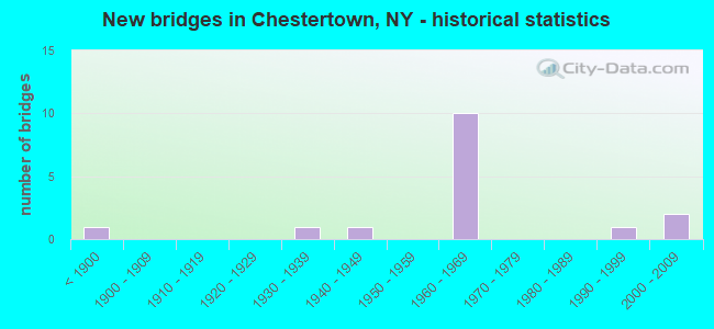
- New bridges - historical statistics
- 1Before 1900
- 11930-1939
- 11940-1949
- 101960-1969
- 11990-1999
- 22000-2009

- Reconstructed bridges - Historical Statistics
- 21980-1989
- 11990-1999


- Bridge Condition - Deck
- 36.4%Very good
- 36.4%Satisfactory
- 9.1%Fair
- 9.1%Poor
- 9.1%Critical

- Bridge Condition - Superstructure
- 27.3%Very good
- 18.2%Good
- 27.3%Satisfactory
- 9.1%Fair
- 9.1%Poor
- 9.1%Imminent failure

- Bridge Condition - Substructure
- 9.1%Excellent
- 18.2%Very good
- 18.2%Good
- 36.4%Satisfactory
- 9.1%Fair
- 9.1%Poor

- Bridge Condition - Channel
- 30.0%Very good
- 50.0%Good
- 10.0%Satisfactory
- 10.0%Fair

- Bridge Condition - Culverts
- 50.0%Good
- 50.0%Satisfactory
Find on map >> Show street view
Structure Number: 100489, Location: 0.4 MI E JCT 8 & I87 (Lat: 43.670800, Lng: -73.771064), Route carried "on" structure: State highway 8, Year Built: 1930, Year Reconstructed: 1993, Status: Open, Structure Length: 8.14m (26.71ft), Average Daily Traffic: 1,814 (year 2016), Truck Traffic: 7%, Average Future Daily Traffic: 1,934 (year 2040), Features Intersected: SCHROON RIVER
Minimum Vertical Clearance: 4.52m (14.83ft), Kilometerpoint: 46.371, Lanes on structure: 2, Base Highway Network: Yes, Owner: State Highway Agency, Approaching Roadway Width: 7.9m (25.9ft), Skew: 3 degrees, Material/Design: Steel, Design/Construction: Truss - Thru, Number Of Spans In Main Unit: 2, Length of Maximum Span: 39.6m (129.9ft), Curb-To-Curb Width: 7.3m (24.0ft), Out-to-Out Width: 8.0m (26.2ft)
Condition: Deck: Satisfactory, Superstructure: Poor, Substructure: Satisfactory, Channel: Good, Operating Rating: 54.4 metric tons, Method Used To Determine Operating Rating: Load Factor (LF), Inventory Rating: 32.7 metric tons, Method Used To Determine Inventory Rating: Load Factor (LF), Structural Evaluation: Meets minimum limits, Deck Geometry: Meets minimum limits, Waterway Adequacy: Somewhat better than minimum adequacy, Approach Roadway Alignment: Equal to present desirable criteria, Length Of Structure Improvement: 8.13m (26.67ft), Designated Inspection Frequency: Every 24 months, Critical Feature Inspection Frequency: Every 24 months, Inspection Date: July 2020, Critical Feature Inspection Date: July 2020, Bridge Improvement Cost: $5,071,000, Roadway Improvement Cost: $2,970,000, Total Project Cost: $8,041,000 ( Estimate for 2021), Deck Structure Type: Concrete Cast-file-Place, Wearing Surface/Protective System: Wearing Surface: Integral Concrete, Deck Protection: Epoxy Coated Reinforcing
Find on map >> Show street view
Structure Number: 1033591, Location: JCT RTE 8 & I87 (Lat: 43.668381, Lng: -73.779042), Route carried "on" structure: Interstate 87, Year Built: 1966, Status: Open, Structure Length: 4.60m (15.09ft), Average Daily Traffic: 6,818 (year 2005), Truck Traffic: 26%, Design Load: H 20, Features Intersected: RTE 8
Minimum Vertical Clearance: 30+ m (98+ ft), Kilometerpoint: 48.978, Lanes on structure: 2, Lanes under structure: 2, Base Highway Network: Yes, Owner: State Highway Agency, Approaching Roadway Width: 12.2m (40.0ft), Skew: 2 degrees, Material/Design: Steel, Design/Construction: Stringer/Multi-beam, Number Of Spans In Main Unit: 3, Length of Maximum Span: 16.7m (54.8ft), Curb-To-Curb Width: 12.0m (39.4ft), Out-to-Out Width: 12.9m (42.3ft)
Condition: Deck: Satisfactory, Superstructure: Good, Substructure: Satisfactory, Operating Rating: 92.5 metric tons, Method Used To Determine Operating Rating: Load Factor (LF), Inventory Rating: 55.3 metric tons, Method Used To Determine Inventory Rating: Load Factor (LF), Structural Evaluation: Equal to present minimum criteria, Deck Geometry: Equal to present minimum criteria, Underclear: Meets minimum limits, Approach Roadway Alignment: Equal to present desirable criteria, Length Of Structure Improvement: 4.60m (15.09ft), Designated Inspection Frequency: Every 24 months, Inspection Date: June 2021, Bridge Improvement Cost: $1,333,000, Roadway Improvement Cost: $781,000, Total Project Cost: $2,114,000 ( Estimate for 2021), Deck Structure Type: Concrete Cast-file-Place, Wearing Surface/Protective System: Wearing Surface: Monolithic Concrete
Find on map >> Show street view
Structure Number: 1033592, Location: JCT RTE 8 & I87 (Lat: 43.668758, Lng: -73.777386), Route carried "on" structure: Interstate 87, Year Built: 1966, Status: Open, Structure Length: 4.60m (15.09ft), Average Daily Traffic: 4,278 (year 2018), Truck Traffic: 27%, Average Future Daily Traffic: 5,095 (year 2040), Design Load: H 20, Features Intersected: RTE 8
Minimum Vertical Clearance: 30+ m (98+ ft), Kilometerpoint: 48.978, Lanes on structure: 2, Lanes under structure: 2, Base Highway Network: Yes, Owner: State Highway Agency, Approaching Roadway Width: 12.2m (40.0ft), Skew: 2 degrees, Material/Design: Steel, Design/Construction: Stringer/Multi-beam, Number Of Spans In Main Unit: 3, Length of Maximum Span: 16.7m (54.8ft), Curb-To-Curb Width: 11.9m (39.0ft), Out-to-Out Width: 12.8m (42.0ft)
Condition: Deck: Satisfactory, Superstructure: Good, Substructure: Satisfactory, Operating Rating: 87.1 metric tons, Method Used To Determine Operating Rating: Load Factor (LF), Inventory Rating: 51.7 metric tons, Method Used To Determine Inventory Rating: Load Factor (LF), Structural Evaluation: Equal to present minimum criteria, Deck Geometry: Equal to present minimum criteria, Underclear: Meets minimum limits, Approach Roadway Alignment: Equal to present desirable criteria, Length Of Structure Improvement: 4.60m (15.09ft), Designated Inspection Frequency: Every 24 months, Inspection Date: June 2021, Bridge Improvement Cost: $1,341,000, Roadway Improvement Cost: $785,000, Total Project Cost: $2,126,000 ( Estimate for 2021), Deck Structure Type: Concrete Cast-file-Place, Wearing Surface/Protective System: Wearing Surface: Monolithic Concrete
Find on map >> Show street view
Structure Number: 1033601, Location: 0.5 MI N JCT 8 & I87 (Lat: 43.673500, Lng: -73.784931), Route carried "on" structure: Interstate 87, Year Built: 1965, Status: Open, Structure Length: 3.23m (10.60ft), Average Daily Traffic: 6,818 (year 2005), Truck Traffic: 23%, Design Load: H 20, Features Intersected: CHESTER CREEK
Minimum Vertical Clearance: 30+ m (98+ ft), Kilometerpoint: 49.782, Lanes on structure: 2, Base Highway Network: Yes, Owner: State Highway Agency, Approaching Roadway Width: 12.2m (40.0ft), Skew: 1 degrees, Material/Design: Steel, Design/Construction: Stringer/Multi-beam, Number Of Spans In Main Unit: 1, Length of Maximum Span: 30.5m (100.1ft), Curb-To-Curb Width: 11.8m (38.7ft), Out-to-Out Width: 12.7m (41.7ft)
Condition: Deck: Satisfactory, Superstructure: Satisfactory, Substructure: Satisfactory, Channel: Good, Operating Rating: 57.2 metric tons, Method Used To Determine Operating Rating: Load Factor (LF), Inventory Rating: 33.6 metric tons, Method Used To Determine Inventory Rating: Load Factor (LF), Structural Evaluation: Equal to present minimum criteria, Deck Geometry: Equal to present minimum criteria, Waterway Adequacy: Superior to present desirable criteria, Approach Roadway Alignment: Equal to present desirable criteria, Length Of Structure Improvement: 3.23m (10.60ft), Designated Inspection Frequency: Every 24 months, Inspection Date: April 2021, Bridge Improvement Cost: $1,030,000, Roadway Improvement Cost: $603,000, Total Project Cost: $1,633,000 ( Estimate for 2021), Deck Structure Type: Concrete Cast-file-Place, Wearing Surface/Protective System: Wearing Surface: Integral Concrete
Find on map >> Show street view
Structure Number: 1033602, Location: 0.5 MI N JCT 8 & I87 (Lat: 43.673878, Lng: -73.784489), Route carried "on" structure: Interstate 87, Year Built: 1965, Status: Open, Structure Length: 2.99m (9.81ft), Average Daily Traffic: 3,880 (year 2018), Truck Traffic: 27%, Average Future Daily Traffic: 4,621 (year 2040), Design Load: H 20, Features Intersected: CHESTER CREEK
Minimum Vertical Clearance: 30+ m (98+ ft), Kilometerpoint: 49.782, Lanes on structure: 2, Base Highway Network: Yes, Owner: State Highway Agency, Approaching Roadway Width: 12.2m (40.0ft), Skew: 1 degrees, Material/Design: Steel, Design/Construction: Stringer/Multi-beam, Number Of Spans In Main Unit: 1, Length of Maximum Span: 28.3m (92.8ft), Curb-To-Curb Width: 11.9m (39.0ft), Out-to-Out Width: 12.8m (42.0ft)
Condition: Deck: Fair, Superstructure: Satisfactory, Substructure: Good, Channel: Very good, Operating Rating: 57.2 metric tons, Method Used To Determine Operating Rating: Load Factor (LF), Inventory Rating: 33.6 metric tons, Method Used To Determine Inventory Rating: Load Factor (LF), Structural Evaluation: Equal to present minimum criteria, Deck Geometry: Equal to present minimum criteria, Waterway Adequacy: Superior to present desirable criteria, Approach Roadway Alignment: Equal to present desirable criteria, Length Of Structure Improvement: 2.98m (9.78ft), Designated Inspection Frequency: Every 24 months, Inspection Date: April 2021, Bridge Improvement Cost: $1,008,000, Roadway Improvement Cost: $591,000, Total Project Cost: $1,599,000 ( Estimate for 2021), Deck Structure Type: Concrete Cast-file-Place, Wearing Surface/Protective System: Wearing Surface: Integral Concrete
Find on map >> Show street view
Structure Number: 105368, Location: AT EXIT 24 OF I87 (Lat: 43.603653, Lng: -73.731078), Route carried "on" structure: County highway 915, Year Built: 1965, Status: Open, Structure Length: 7.22m (23.69ft), Average Daily Traffic: 1,193 (year 2016), Truck Traffic: 7%, Average Future Daily Traffic: 1,670 (year 2036), Design Load: HS 20, Features Intersected: 87I 87I17101255 NB, RTE
Minimum Vertical Clearance: 30+ m (98+ ft), Kilometerpoint: 0.016, Lanes on structure: 2, Lanes under structure: 4, Base Highway Network: Yes, Owner: State Highway Agency, Approaching Roadway Width: 8.5m (27.9ft), Material/Design: Steel, Design/Construction: Stringer/Multi-beam, Number Of Spans In Main Unit: 4, Length of Maximum Span: 21.6m (70.9ft), Curb or Sidewalk Widths: Left: 0.5m (1.6ft), Right: 0.5m (1.6ft), Curb-To-Curb Width: 8.6m (28.2ft), Out-to-Out Width: 10.1m (33.1ft)
Condition: Deck: Poor, Superstructure: Satisfactory, Substructure: Poor, Operating Rating: 59.0 metric tons, Method Used To Determine Operating Rating: Load Factor (LF), Inventory Rating: 32.7 metric tons, Method Used To Determine Inventory Rating: Load Factor (LF), Structural Evaluation: Meets minimum limits, Deck Geometry: Somewhat better than minimum adequacy, Underclear: High priority of corrective action, Approach Roadway Alignment: Equal to present desirable criteria, Length Of Structure Improvement: 7.22m (23.69ft), Designated Inspection Frequency: Every 24 months, Inspection Date: June 2021, Bridge Improvement Cost: $1,504,000, Roadway Improvement Cost: $881,000, Total Project Cost: $2,385,000 ( Estimate for 2021), Deck Structure Type: Concrete Cast-file-Place, Wearing Surface/Protective System: Wearing Surface: Bituminous, Membrane: Other
Find on map >> Show street view
Structure Number: 105441, Location: 0.4 MI E JCT 8 & 9 (Lat: 43.658464, Lng: -73.794586), Route carried "on" structure: State highway 8, Year Built: 1967, Status: Open, Structure Length: 1.01m (3.31ft), Average Daily Traffic: 3,837 (year 2019), Truck Traffic: 8%, Average Future Daily Traffic: 4,092 (year 2040), Features Intersected: CHESTER CREEK
Minimum Vertical Clearance: 30+ m (98+ ft), Kilometerpoint: 44.006, Lanes on structure: 2, Base Highway Network: Yes, Owner: State Highway Agency, Approaching Roadway Width: 12.2m (40.0ft), Skew: 2 degrees, Material/Design: Concrete continuous, Design/Construction: Culvert, Number Of Spans In Main Unit: 2, Length of Maximum Span: 4.8m (15.7ft)
Condition: Channel: Fair, Culverts: Good, Operating Rating: 76.0 metric tons, Method Used To Determine Operating Rating: Field evaluation and documented engineering judgment, Inventory Rating: 32.7 metric tons, Method Used To Determine Inventory Rating: Field evaluation and documented engineering judgment, Structural Evaluation: Better than present minimum criteria, Waterway Adequacy: Superior to present desirable criteria, Approach Roadway Alignment: Equal to present desirable criteria, Length Of Structure Improvement: 1.00m (3.28ft), Designated Inspection Frequency: Every 24 months, Inspection Date: May 2021, Bridge Improvement Cost: $216,000, Roadway Improvement Cost: $127,000, Total Project Cost: $343,000 ( Estimate for 2021)
Find on map >> Show street view
Structure Number: 106902, Location: JCT RTE 8 & RTE 9 (Lat: 43.655731, Lng: -73.801269), Route carried "on" structure: US 9, Year Built: 1967, Status: Open, Structure Length: 1.01m (3.31ft), Average Daily Traffic: 1,643 (year 2019), Truck Traffic: 11%, Average Future Daily Traffic: 1,713 (year 2040), Design Load: H 20, Features Intersected: CHESTER CREEK
Minimum Vertical Clearance: 30+ m (98+ ft), Kilometerpoint: 44.135, Lanes on structure: 2, Base Highway Network: Yes, Owner: State Highway Agency, Approaching Roadway Width: 12.2m (40.0ft), Material/Design: Concrete continuous, Design/Construction: Culvert, Number Of Spans In Main Unit: 2, Length of Maximum Span: 4.5m (14.8ft), Curb-To-Curb Width: 11.9m (39.0ft), Out-to-Out Width: 13.0m (42.7ft)
Condition: Channel: Very good, Culverts: Satisfactory, Operating Rating: 54.4 metric tons, Method Used To Determine Operating Rating: Load Factor (LF), Inventory Rating: 32.7 metric tons, Method Used To Determine Inventory Rating: Load Factor (LF), Structural Evaluation: Equal to present minimum criteria, Deck Geometry: Equal to present minimum criteria, Waterway Adequacy: Superior to present desirable criteria, Approach Roadway Alignment: Equal to present minimum criteria, Length Of Structure Improvement: 1.00m (3.28ft), Designated Inspection Frequency: Every 24 months, Inspection Date: June 2020, Bridge Improvement Cost: $428,000, Roadway Improvement Cost: $250,000, Total Project Cost: $678,000 ( Estimate for 2021), Wearing Surface/Protective System: Wearing Surface: Integral Concrete
Find on map >> Show street view
Structure Number: 330514, Location: 0.2 MI E EXIT 24-NORTHWAY (Lat: 43.604667, Lng: -73.728217), Route carried "on" structure: County highway , Year Built: 1998, Status: Open, Structure Length: 4.79m (15.72ft), Average Daily Traffic: 2,217 (year 2018), Truck Traffic: 6%, Average Future Daily Traffic: 3,104 (year 2038), Design Load: HS 25 or greater, Features Intersected: SCHROON RIVER, Facility Carried by Structure: RIVERBANK ROAD
Minimum Vertical Clearance: 30+ m (98+ ft), Kilometerpoint: 0.129, Lanes on structure: 2, Owner: County Highway Agency, Approaching Roadway Width: 10.4m (34.1ft), Material/Design: Steel, Design/Construction: Stringer/Multi-beam, Number Of Spans In Main Unit: 1, Length of Maximum Span: 46.3m (151.9ft), Curb-To-Curb Width: 10.4m (34.1ft), Out-to-Out Width: 11.0m (36.1ft)
Condition: Deck: Very good, Superstructure: Very good, Substructure: Very good, Channel: Satisfactory, Operating Rating: 82.6 metric tons, Method Used To Determine Operating Rating: Load Factor (LF), Inventory Rating: 49.0 metric tons, Method Used To Determine Inventory Rating: Load Factor (LF), Structural Evaluation: Equal to present desirable criteria, Deck Geometry: Somewhat better than minimum adequacy, Waterway Adequacy: Better than present minimum criteria, Approach Roadway Alignment: Equal to present desirable criteria, Length Of Structure Improvement: 4.78m (15.68ft), Designated Inspection Frequency: Every 24 months, Inspection Date: July 2020, Bridge Improvement Cost: $1,462,000, Roadway Improvement Cost: $856,000, Total Project Cost: $2,318,000 ( Estimate for 2021), Deck Structure Type: Concrete Cast-file-Place, Wearing Surface/Protective System: Deck Protection: Epoxy Coated Reinforcing
Find on map >> Show street view
Structure Number: 330515, Location: 1 MI NORTHWEST I87 EXIT24 (Lat: 43.609681, Lng: -73.737403), Route carried "on" structure: County highway , Year Built: 1896, Year Reconstructed: 1990, Status: Closed, Structure Length: 2.68m (8.79ft), Average Daily Traffic: 162 (year 1983), Truck Traffic: 10%, Average Future Daily Traffic: 227 (year 2003), Features Intersected: SCHROON RIVER, Facility Carried by Structure: CR10 TO RIVER RD
Minimum Vertical Clearance: 30+ m (98+ ft), Kilometerpoint: 0.000, Lanes on structure: 1, Owner: County Highway Agency, Approaching Roadway Width: 3.7m (12.1ft), Material/Design: Aluminum, Iron, Design/Construction: Truss - Thru, Number Of Spans In Main Unit: 1, Length of Maximum Span: 26.5m (86.9ft), Curb-To-Curb Width: 3.8m (12.5ft), Out-to-Out Width: 3.9m (12.8ft)
Condition: Deck: Critical, Superstructure: Imminent failure, Substructure: Fair, Channel: Good, Waterway Adequacy: Meets minimum limits, Approach Roadway Alignment: Meets minimum limits, Bridge Posting: Required (Relationship of Operating Rating to Maximum Legal Load: > 39.9% below), Length Of Structure Improvement: 2.68m (8.79ft), Designated Inspection Frequency: Every 12 months, Critical Feature Inspection Frequency: Every 12 months, Inspection Date: July 2021, Critical Feature Inspection Date: July 2021, Bridge Improvement Cost: $1,050,000, Roadway Improvement Cost: $615,000, Total Project Cost: $1,665,000 ( Estimate for 2021), Deck Structure Type: Wood or Timber, Wearing Surface/Protective System: Wearing Surface: Wood or Timber
Find on map >> Show street view
Structure Number: 330517, Location: 1 MI NW OF EXIT 25 - I87 (Lat: 43.676400, Lng: -73.779897), Route carried "on" structure: County highway , Year Built: 2005, Status: Open, Structure Length: 6.22m (20.41ft), Truck Traffic: 8%, Design Load: HS 25 or greater, Features Intersected: SCHROON RIVER, Facility Carried by Structure: VALENTINE ROAD
Minimum Vertical Clearance: 30+ m (98+ ft), Kilometerpoint: 0.000, Lanes on structure: 2, Owner: County Highway Agency, Approaching Roadway Width: 9.1m (29.9ft), Material/Design: Prestressed concrete continuous, Design/Construction: Box Beam or Girders - Multiple, Number Of Spans In Main Unit: 2, Length of Maximum Span: 30.5m (100.1ft), Curb-To-Curb Width: 9.1m (29.9ft), Out-to-Out Width: 10.1m (33.1ft)
Condition: Deck: Very good, Superstructure: Very good, Substructure: Excellent, Channel: Very good, Operating Rating: 61.7 metric tons, Method Used To Determine Operating Rating: Load Factor (LF), Inventory Rating: 32.7 metric tons, Method Used To Determine Inventory Rating: Load Factor (LF), Structural Evaluation: Equal to present desirable criteria, Deck Geometry: Better than present minimum criteria, Waterway Adequacy: Superior to present desirable criteria, Approach Roadway Alignment: Better than present minimum criteria, Length Of Structure Improvement: 6.21m (20.37ft), Designated Inspection Frequency: Every 24 months, Inspection Date: June 2021, Bridge Improvement Cost: $1,885,000, Roadway Improvement Cost: $1,104,000, Total Project Cost: $2,989,000 ( Estimate for 2021), Deck Structure Type: Concrete Cast-file-Place, Wearing Surface/Protective System: Wearing Surface: Integral Concrete, Deck Protection: Epoxy Coated Reinforcing
Find on map >> Show street view
Structure Number: 330518, Location: 2 MI.S.OF BRANDT LAKE (Lat: 43.654150, Lng: -73.761250), Route carried "on" structure: County highway , Year Built: 1941, Year Reconstructed: 1991, Status: Open, Structure Length: 4.18m (13.71ft), Average Daily Traffic: 500 (year 2020), Truck Traffic: 5%, Average Future Daily Traffic: 700 (year 2040), Design Load: HS 20, Features Intersected: SCHROON RIVER, Facility Carried by Structure: CR31 HORICON RD
Minimum Vertical Clearance: 30+ m (98+ ft), Kilometerpoint: 0.177, Lanes on structure: 2, Owner: County Highway Agency, Approaching Roadway Width: 6.7m (22.0ft), Skew: 2 degrees, Material/Design: Steel, Design/Construction: Truss - Thru, Number Of Spans In Main Unit: 1, Length of Maximum Span: 40.2m (131.9ft), Curb or Sidewalk Widths: Left: 0.0m, Right: 1.3m (4.3ft), Curb-To-Curb Width: 6.7m (22.0ft), Out-to-Out Width: 7.2m (23.6ft)
Condition: Deck: Very good, Superstructure: Fair, Substructure: Good, Channel: Good, Operating Rating: 55.3 metric tons, Method Used To Determine Operating Rating: Load Factor (LF), Inventory Rating: 32.7 metric tons, Method Used To Determine Inventory Rating: Load Factor (LF), Structural Evaluation: Somewhat better than minimum adequacy, Deck Geometry: Meets minimum limits, Waterway Adequacy: Meets minimum limits, Approach Roadway Alignment: Better than present minimum criteria, Length Of Structure Improvement: 4.17m (13.68ft), Designated Inspection Frequency: Every 24 months, Critical Feature Inspection Frequency: Every 24 months, Inspection Date: June 2020, Critical Feature Inspection Date: June 2020, Bridge Improvement Cost: $2,884,000, Roadway Improvement Cost: $1,689,000, Total Project Cost: $4,573,000 ( Estimate for 2021), Deck Structure Type: Concrete Cast-file-Place, Wearing Surface/Protective System: Wearing Surface: Bituminous, Deck Protection: Epoxy Coated Reinforcing
Find on map >> Show street view
Structure Number: 330523, Location: IN STARBUCKVILLE (Lat: 43.674347, Lng: -73.778356), Route carried "on" structure: County highway , Year Built: 2005, Status: Open, Structure Length: 1.16m (3.81ft), Average Daily Traffic: 1,098 (year 2019), Truck Traffic: 8%, Average Future Daily Traffic: 1,537 (year 2039), Design Load: HS 25 or greater, Features Intersected: CHESTER CREEK, Facility Carried by Structure: VALENTINE ROAD
Minimum Vertical Clearance: 30+ m (98+ ft), Kilometerpoint: 5.615, Lanes on structure: 2, Owner: County Highway Agency, Approaching Roadway Width: 9.1m (29.9ft), Skew: 3 degrees, Material/Design: Concrete, Design/Construction: Frame, Number Of Spans In Main Unit: 1, Length of Maximum Span: 9.1m (29.9ft), Curb-To-Curb Width: 9.0m (29.5ft), Out-to-Out Width: 10.0m (32.8ft)
Condition: Deck: Very good, Superstructure: Very good, Substructure: Very good, Channel: Good, Operating Rating: 79.1 metric tons, Method Used To Determine Operating Rating: Field evaluation and documented engineering judgment, Inventory Rating: 40.8 metric tons, Method Used To Determine Inventory Rating: Field evaluation and documented engineering judgment, Structural Evaluation: Equal to present desirable criteria, Deck Geometry: Somewhat better than minimum adequacy, Waterway Adequacy: Superior to present desirable criteria, Approach Roadway Alignment: Equal to present desirable criteria, Length Of Structure Improvement: 1.15m (3.77ft), Designated Inspection Frequency: Every 24 months, Inspection Date: April 2020, Bridge Improvement Cost: $452,000, Roadway Improvement Cost: $265,000, Total Project Cost: $717,000 ( Estimate for 2021), Wearing Surface/Protective System: Wearing Surface: Bituminous
Find on map >> Show street view
Structure Number: 1033591, Location: JCT RTE 8 & I87 (Lat: 43.668381, Lng: -73.779042), Route carried "under" structure: State highway 8, Year Built: 1966, Structure Length: 0. m, Average Daily Traffic: 596 (year 2000), Features Intersected: RTE 8
Minimum Vertical Clearance: 4.57m (14.99ft), Kilometerpoint: 46.017, Lanes on structure: 2, Lanes under structure: 2, Material/Design: Steel, Design/Construction: Stringer/Multi-beam, Length of Maximum Span: 16.7m (54.8ft)
Find on map >> Show street view
Structure Number: 1033592, Location: JCT RTE 8 & I87 (Lat: 43.668758, Lng: -73.777386), Route carried "under" structure: State highway 8, Year Built: 1966, Structure Length: 0. m, Average Daily Traffic: 596 (year 2000), Features Intersected: RTE 8
Minimum Vertical Clearance: 4.52m (14.83ft), Kilometerpoint: 46.017, Lanes on structure: 2, Lanes under structure: 2, Material/Design: Steel, Design/Construction: Stringer/Multi-beam, Length of Maximum Span: 16.7m (54.8ft)
Find on map >> Show street view
Structure Number: 105368, Location: AT EXIT 24 OF I87 (Lat: 43.603653, Lng: -73.731078), Route carried "under" structure: Interstate 87, Year Built: 1965, Structure Length: 0. m, Average Daily Traffic: 7,019 (year 1998), Features Intersected: 87I 87I17101255 NB, RTE, Facility Carried by Structure: RTE 915
Minimum Vertical Clearance: 5.84m (19.16ft), Kilometerpoint: 40.869, Lanes on structure: 2, Lanes under structure: 2, Material/Design: Steel, Design/Construction: Stringer/Multi-beam, Length of Maximum Span: 21.6m (70.9ft)