Bridge Statistics for Cherry Creek, New York (NY)
Condition, Traffic, Stress, Structural Evaluation, Project Costs
- National Bridge Inventory (NBI) Statistics
- 11Number of bridges
- 49ft / 15.1mTotal length
- $9,915,000Total costs
- 6,078Total average daily traffic
- 701Total average daily truck traffic
- 7,289Total future (year 2036) average daily traffic
- National Bridge Inventory (NBI) Registered Bridges for Cherry Creek
- No street view available for this location
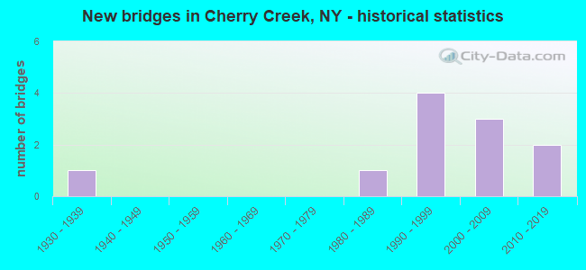
- New bridges - historical statistics
- 11930-1939
- 11980-1989
- 41990-1999
- 32000-2009
- 22010-2019


- Bridge Condition - Deck
- 28.6%Excellent
- 42.9%Very good
- 14.3%Good
- 14.3%Satisfactory

- Bridge Condition - Superstructure
- 28.6%Excellent
- 57.1%Very good
- 14.3%Satisfactory

- Bridge Condition - Substructure
- 28.6%Excellent
- 57.1%Very good
- 14.3%Good

- Bridge Condition - Channel
- 27.3%Very good
- 45.5%Good
- 18.2%Satisfactory
- 9.1%Fair

- Bridge Condition - Culverts
- 50.0%Very good
- 25.0%Good
- 25.0%Satisfactory
Find on map >> Show street view
Structure Number: 103241, Location: 4.7 MI NW JCT RTS 83 & 62 (Lat: 42.299269, Lng: -79.097408), Route carried "on" structure: State highway 83, Year Built: 1998, Status: Open, Structure Length: 1.92m (6.30ft), Average Daily Traffic: 1,562 (year 2018), Truck Traffic: 14%, Average Future Daily Traffic: 1,577 (year 2040), Design Load: HS 25 or greater, Features Intersected: CHERRY CREEK
Minimum Vertical Clearance: 30+ m (98+ ft), Kilometerpoint: 7.498, Lanes on structure: 2, Base Highway Network: Yes, Owner: State Highway Agency, Approaching Roadway Width: 9.1m (29.9ft), Material/Design: Prestressed concrete, Design/Construction: Box Beam or Girders - Multiple, Number Of Spans In Main Unit: 1, Length of Maximum Span: 18.2m (59.7ft), Curb or Sidewalk Widths: Left: 1.5m (4.9ft), Right: 1.5m (4.9ft), Curb-To-Curb Width: 9.1m (29.9ft), Out-to-Out Width: 12.8m (42.0ft)
Condition: Deck: Very good, Superstructure: Very good, Substructure: Very good, Channel: Good, Operating Rating: 69.9 metric tons, Method Used To Determine Operating Rating: Load Factor (LF), Inventory Rating: 41.7 metric tons, Method Used To Determine Inventory Rating: Load Factor (LF), Structural Evaluation: Equal to present desirable criteria, Deck Geometry: Somewhat better than minimum adequacy, Waterway Adequacy: Equal to present minimum criteria, Approach Roadway Alignment: Equal to present desirable criteria, Length Of Structure Improvement: 1.92m (6.30ft), Designated Inspection Frequency: Every 24 months, Inspection Date: April 2020, Bridge Improvement Cost: $606,000, Roadway Improvement Cost: $355,000, Total Project Cost: $960,000 ( Estimate for 2021), Wearing Surface/Protective System: Wearing Surface: Integral Concrete
Find on map >> Show street view
Structure Number: 103242, Location: 2.6 MI S JCT RTS 83 & 322 (Lat: 42.332892, Lng: -79.090217), Route carried "on" structure: State highway 83, Year Built: 1998, Status: Open, Structure Length: 0.79m (2.59ft), Average Daily Traffic: 1,562 (year 2018), Truck Traffic: 14%, Average Future Daily Traffic: 1,577 (year 2040), Design Load: HS 25 or greater, Features Intersected: BLAISDELL CREEK
Minimum Vertical Clearance: 30+ m (98+ ft), Kilometerpoint: 11.376, Lanes on structure: 2, Base Highway Network: Yes, Owner: State Highway Agency, Approaching Roadway Width: 10.4m (34.1ft), Skew: 2 degrees, Material/Design: Concrete, Design/Construction: Culvert, Number Of Spans In Main Unit: 1, Length of Maximum Span: 7.3m (24.0ft)
Condition: Channel: Very good, Culverts: Very good, Operating Rating: 77.7 metric tons, Method Used To Determine Operating Rating: Field evaluation and documented engineering judgment, Inventory Rating: 40.8 metric tons, Method Used To Determine Inventory Rating: Field evaluation and documented engineering judgment, Structural Evaluation: Equal to present desirable criteria, Waterway Adequacy: Equal to present minimum criteria, Approach Roadway Alignment: Equal to present desirable criteria, Length Of Structure Improvement: 0.79m (2.59ft), Designated Inspection Frequency: Every 24 months, Inspection Date: May 2020, Bridge Improvement Cost: $489,000, Roadway Improvement Cost: $286,000, Total Project Cost: $775,000 ( Estimate for 2021), Wearing Surface/Protective System: Wearing Surface: Bituminous
Find on map >> Show street view
Structure Number: 221236, Location: IN CHERRY CREEK (Lat: 42.294075, Lng: -79.091992), Route carried "on" structure: Other road , Year Built: 2019, Status: Open, Structure Length: 1.46m (4.79ft), Average Daily Traffic: 134 (year 2016), Truck Traffic: 6%, Average Future Daily Traffic: 188 (year 2036), Design Load: HS 25 or greater, Features Intersected: CHERRY CREEK, Facility Carried by Structure: DEPOT STREET
Minimum Vertical Clearance: 30+ m (98+ ft), Kilometerpoint: 0.064, Lanes on structure: 2, Owner: County Highway Agency, Approaching Roadway Width: 6.1m (20.0ft), Material/Design: Prestressed concrete, Design/Construction: Box Beam or Girders - Multiple, Number Of Spans In Main Unit: 1, Length of Maximum Span: 13.4m (44.0ft), Curb-To-Curb Width: 6.6m (21.7ft), Out-to-Out Width: 7.4m (24.3ft)
Condition: Deck: Excellent, Superstructure: Excellent, Substructure: Excellent, Channel: Good, Operating Rating: 78.9 metric tons, Method Used To Determine Operating Rating: Load Factor (LF), Inventory Rating: 47.2 metric tons, Method Used To Determine Inventory Rating: Load Factor (LF), Structural Evaluation: Superior to present desirable criteria, Deck Geometry: Meets minimum limits, Waterway Adequacy: Meets minimum limits, Approach Roadway Alignment: Equal to present desirable criteria, Length Of Structure Improvement: 1.46m (4.79ft), Designated Inspection Frequency: Every 24 months, Inspection Date: June 2021, Bridge Improvement Cost: $319,000, Roadway Improvement Cost: $187,000, Total Project Cost: $506,000 ( Estimate for 2021), Wearing Surface/Protective System: Wearing Surface: Bituminous, Membrane: Other
Find on map >> Show street view
Structure Number: 226703, Location: 0.9 MI W OF CHERRY CREEK (Lat: 42.297633, Lng: -79.115606), Route carried "on" structure: Other road , Year Built: 2008, Status: Open, Structure Length: 1.04m (3.41ft), Average Daily Traffic: 91 (year 2016), Truck Traffic: 2%, Average Future Daily Traffic: 127 (year 2036), Design Load: HS 25 or greater, Features Intersected: BR CHERRY CREEK, Facility Carried by Structure: CROSS ROAD
Minimum Vertical Clearance: 30+ m (98+ ft), Kilometerpoint: 0.467, Lanes on structure: 2, Owner: County Highway Agency, Approaching Roadway Width: 6.1m (20.0ft), Material/Design: Prestressed concrete, Design/Construction: Box Beam or Girders - Multiple, Number Of Spans In Main Unit: 1, Length of Maximum Span: 9.8m (32.2ft), Curb-To-Curb Width: 7.8m (25.6ft), Out-to-Out Width: 8.7m (28.5ft)
Condition: Deck: Very good, Superstructure: Very good, Substructure: Very good, Channel: Very good, Operating Rating: 80.7 metric tons, Method Used To Determine Operating Rating: Load Factor (LF), Inventory Rating: 48.1 metric tons, Method Used To Determine Inventory Rating: Load Factor (LF), Structural Evaluation: Equal to present desirable criteria, Deck Geometry: Equal to present minimum criteria, Waterway Adequacy: Equal to present minimum criteria, Approach Roadway Alignment: Equal to present desirable criteria, Length Of Structure Improvement: 1.03m (3.38ft), Designated Inspection Frequency: Every 24 months, Inspection Date: October 2020, Bridge Improvement Cost: $406,000, Roadway Improvement Cost: $238,000, Total Project Cost: $643,000 ( Estimate for 2021), Wearing Surface/Protective System: Wearing Surface: Bituminous, Membrane: Other
Find on map >> Show street view
Structure Number: 332407, Location: 2.9 MI SW OF CHERRY CREEK (Lat: 42.260844, Lng: -79.155403), Route carried "on" structure: County highway , Year Built: 1986, Status: Open, Structure Length: 1.25m (4.10ft), Average Daily Traffic: 323 (year 2018), Truck Traffic: 6%, Average Future Daily Traffic: 452 (year 2038), Design Load: HS 20, Features Intersected: CLEAR CREEK, Facility Carried by Structure: COUNTY ROAD 66
Minimum Vertical Clearance: 30+ m (98+ ft), Kilometerpoint: 0.016, Lanes on structure: 2, Owner: County Highway Agency, Approaching Roadway Width: 6.1m (20.0ft), Skew: 3 degrees, Material/Design: Prestressed concrete, Design/Construction: Box Beam or Girders - Multiple, Number Of Spans In Main Unit: 1, Length of Maximum Span: 11.8m (38.7ft), Curb-To-Curb Width: 8.5m (27.9ft), Out-to-Out Width: 9.3m (30.5ft)
Condition: Deck: Satisfactory, Superstructure: Satisfactory, Substructure: Very good, Channel: Satisfactory, Operating Rating: 63.8 metric tons, Method Used To Determine Operating Rating: Load and Resistance Factor Rating (LRFR) rating reported by rating factor(RF) method using HL-93 loadings, Inventory Rating: 41.8 metric tons, Method Used To Determine Inventory Rating: Load and Resistance Factor Rating (LRFR) rating reported by rating factor(RF) method using HL-93 loadings, Structural Evaluation: Equal to present minimum criteria, Deck Geometry: Equal to present minimum criteria, Waterway Adequacy: Somewhat better than minimum adequacy, Approach Roadway Alignment: Equal to present minimum criteria, Length Of Structure Improvement: 1.24m (4.07ft), Designated Inspection Frequency: Every 24 months, Inspection Date: June 2021, Bridge Improvement Cost: $566,000, Roadway Improvement Cost: $331,000, Total Project Cost: $897,000 ( Estimate for 2021), Wearing Surface/Protective System: Wearing Surface: Bituminous, Membrane: Other
Find on map >> Show street view
Structure Number: 332408, Location: .7 MI NW JCT CR 29 & SH83 (Lat: 42.297917, Lng: -79.112214), Route carried "on" structure: County highway , Year Built: 1997, Status: Open, Structure Length: 1.40m (4.59ft), Average Daily Traffic: 698 (year 2016), Truck Traffic: 6%, Average Future Daily Traffic: 977 (year 2036), Design Load: HS 25 or greater, Features Intersected: BRANCH CHERRY CRK, Facility Carried by Structure: COUNTY ROAD 29
Minimum Vertical Clearance: 30+ m (98+ ft), Kilometerpoint: 1.577, Lanes on structure: 2, Owner: County Highway Agency, Approaching Roadway Width: 7.6m (24.9ft), Skew: 1 degrees, Material/Design: Prestressed concrete, Design/Construction: Box Beam or Girders - Multiple, Number Of Spans In Main Unit: 1, Length of Maximum Span: 12.8m (42.0ft), Curb-To-Curb Width: 9.4m (30.8ft), Out-to-Out Width: 10.0m (32.8ft)
Condition: Deck: Good, Superstructure: Very good, Substructure: Good, Channel: Fair, Operating Rating: 98.9 metric tons, Method Used To Determine Operating Rating: Load Factor (LF), Inventory Rating: 50.8 metric tons, Method Used To Determine Inventory Rating: Load Factor (LF), Structural Evaluation: Better than present minimum criteria, Deck Geometry: Equal to present minimum criteria, Waterway Adequacy: Meets minimum limits, Approach Roadway Alignment: Somewhat better than minimum adequacy, Length Of Structure Improvement: 1.40m (4.59ft), Designated Inspection Frequency: Every 24 months, Inspection Date: June 2021, Bridge Improvement Cost: $1,339,000, Roadway Improvement Cost: $784,000, Total Project Cost: $2,124,000 ( Estimate for 2021), Wearing Surface/Protective System: Wearing Surface: Integral Concrete
Find on map >> Show street view
Structure Number: 332409, Location: 1.1 MI E OF CHERRY CREEK (Lat: 42.294539, Lng: -79.068828), Route carried "on" structure: County highway , Year Built: 2005, Status: Open, Structure Length: 3.84m (12.60ft), Average Daily Traffic: 386 (year 2017), Truck Traffic: 11%, Average Future Daily Traffic: 540 (year 2037), Design Load: HS 25 or greater, Features Intersected: TRIB DREDGE DITCH, Facility Carried by Structure: CHERRY CK-LEON RD
Minimum Vertical Clearance: 30+ m (98+ ft), Kilometerpoint: 2.574, Lanes on structure: 2, Owner: County Highway Agency, Approaching Roadway Width: 6.1m (20.0ft), Skew: 3 degrees, Material/Design: Prestressed concrete, Design/Construction: Stringer/Multi-beam, Number Of Spans In Main Unit: 1, Length of Maximum Span: 38.0m (124.7ft), Curb-To-Curb Width: 10.3m (33.8ft), Out-to-Out Width: 11.3m (37.1ft)
Condition: Deck: Very good, Superstructure: Very good, Substructure: Very good, Channel: Very good, Operating Rating: 81.6 metric tons, Method Used To Determine Operating Rating: Load and Resistance Factor Rating (LRFR) rating reported by rating factor(RF) method using HL-93 loadings, Inventory Rating: 53.8 metric tons, Method Used To Determine Inventory Rating: Load and Resistance Factor Rating (LRFR) rating reported by rating factor(RF) method using HL-93 loadings, Structural Evaluation: Equal to present desirable criteria, Deck Geometry: Better than present minimum criteria, Waterway Adequacy: Equal to present minimum criteria, Approach Roadway Alignment: Equal to present desirable criteria, Length Of Structure Improvement: 3.84m (12.60ft), Designated Inspection Frequency: Every 24 months, Inspection Date: October 2021, Bridge Improvement Cost: $1,370,000, Roadway Improvement Cost: $802,000, Total Project Cost: $2,172,000 ( Estimate for 2021), Deck Structure Type: Concrete Cast-file-Place, Wearing Surface/Protective System: Wearing Surface: Integral Concrete, Deck Protection: Epoxy Coated Reinforcing
Find on map >> Show street view
Structure Number: 332411, Location: 1.4 MI E OF CHERRY CREEK (Lat: 42.293550, Lng: -79.062944), Route carried "on" structure: County highway , Year Built: 1931, Status: Open, Structure Length: 0.73m (2.40ft), Average Daily Traffic: 386 (year 2017), Truck Traffic: 11%, Average Future Daily Traffic: 540 (year 2037), Features Intersected: DRAINAGE DITCH, Facility Carried by Structure: COUNTY ROAD 70
Minimum Vertical Clearance: 30+ m (98+ ft), Kilometerpoint: 3.105, Lanes on structure: 2, Owner: County Highway Agency, Approaching Roadway Width: 6.1m (20.0ft), Material/Design: Concrete continuous, Design/Construction: Culvert, Number Of Spans In Main Unit: 2, Length of Maximum Span: 3.0m (9.8ft)
Condition: Channel: Good, Culverts: Satisfactory, Operating Rating: 45.4 metric tons, Method Used To Determine Operating Rating: Load Factor (LF), Inventory Rating: 27.2 metric tons, Method Used To Determine Inventory Rating: Load Factor (LF), Structural Evaluation: Equal to present minimum criteria, Waterway Adequacy: Somewhat better than minimum adequacy, Approach Roadway Alignment: Meets minimum limits, Length Of Structure Improvement: 0.73m (2.40ft), Designated Inspection Frequency: Every 24 months, Underwater Inspection Frequency: Every 60 months, Inspection Date: October 2021, Underwater Inspection Date: August 2021, Bridge Improvement Cost: $123,000, Roadway Improvement Cost: $72,000, Total Project Cost: $195,000 ( Estimate for 2021)
Find on map >> Show street view
Structure Number: 332412, Location: 1.4 MI WEST OF CHERRY CRK (Lat: 42.294517, Lng: -79.137758), Route carried "on" structure: County highway , Year Built: 1993, Status: Open, Structure Length: 0.79m (2.59ft), Average Daily Traffic: 344 (year 2018), Truck Traffic: 19%, Average Future Daily Traffic: 482 (year 2038), Design Load: HS 20, Features Intersected: BNCH CHERRY CREEK, Facility Carried by Structure: COUNTY ROAD 85
Minimum Vertical Clearance: 30+ m (98+ ft), Kilometerpoint: 4.376, Lanes on structure: 2, Owner: County Highway Agency, Approaching Roadway Width: 7.3m (24.0ft), Skew: 1 degrees, Material/Design: Concrete, Design/Construction: Culvert, Number Of Spans In Main Unit: 1, Length of Maximum Span: 7.3m (24.0ft), Curb-To-Curb Width: 9.2m (30.2ft), Out-to-Out Width: 11.0m (36.1ft)
Condition: Channel: Good, Culverts: Good, Operating Rating: 77.7 metric tons, Method Used To Determine Operating Rating: Field evaluation and documented engineering judgment, Inventory Rating: 32.7 metric tons, Method Used To Determine Inventory Rating: Field evaluation and documented engineering judgment, Structural Evaluation: Better than present minimum criteria, Deck Geometry: Equal to present minimum criteria, Waterway Adequacy: Meets minimum limits, Approach Roadway Alignment: Equal to present desirable criteria, Length Of Structure Improvement: 0.79m (2.59ft), Designated Inspection Frequency: Every 24 months, Inspection Date: November 2021, Bridge Improvement Cost: $578,000, Roadway Improvement Cost: $339,000, Total Project Cost: $917,000 ( Estimate for 2021)
Find on map >> Show street view
Structure Number: 332602, Location: AT CHERRY CK,CHERRY CK RD (Lat: 42.293344, Lng: -79.091108), Route carried "on" structure: County highway , Year Built: 2012, Status: Open, Structure Length: 1.07m (3.51ft), Average Daily Traffic: 475 (year 2017), Truck Traffic: 6%, Average Future Daily Traffic: 665 (year 2037), Design Load: HS 25 or greater, Features Intersected: CHERRY CREEK, Facility Carried by Structure: CHERRY CREEK RD
Minimum Vertical Clearance: 30+ m (98+ ft), Kilometerpoint: 0.708, Lanes on structure: 2, Owner: County Highway Agency, Approaching Roadway Width: 6.1m (20.0ft), Skew: 3 degrees, Material/Design: Concrete, Design/Construction: Frame, Number Of Spans In Main Unit: 1, Length of Maximum Span: 9.8m (32.2ft), Curb-To-Curb Width: 8.4m (27.6ft), Out-to-Out Width: 9.2m (30.2ft)
Condition: Deck: Excellent, Superstructure: Excellent, Substructure: Excellent, Channel: Satisfactory, Operating Rating: 79.8 metric tons, Method Used To Determine Operating Rating: Load Factor (LF), Inventory Rating: 48.1 metric tons, Method Used To Determine Inventory Rating: Load Factor (LF), Structural Evaluation: Superior to present desirable criteria, Deck Geometry: Somewhat better than minimum adequacy, Waterway Adequacy: Somewhat better than minimum adequacy, Approach Roadway Alignment: Equal to present desirable criteria, Length Of Structure Improvement: 1.06m (3.48ft), Designated Inspection Frequency: Every 24 months, Inspection Date: October 2021, Bridge Improvement Cost: $344,000, Roadway Improvement Cost: $202,000, Total Project Cost: $546,000 ( Estimate for 2021), Wearing Surface/Protective System: Wearing Surface: Bituminous
Find on map >> Show street view
Structure Number: 332603, Location: AT CHERRY CK,RAILROAD AVE (Lat: 42.296333, Lng: -79.094892), Route carried "on" structure: Other road , Year Built: 2007, Status: Open, Structure Length: 0.79m (2.59ft), Average Daily Traffic: 117 (year 2018), Truck Traffic: 17%, Average Future Daily Traffic: 164 (year 2038), Design Load: HS 25 or greater, Features Intersected: CHERRY CREEK, Facility Carried by Structure: RAILROAD AVENUE
Minimum Vertical Clearance: 30+ m (98+ ft), Kilometerpoint: 0.338, Lanes on structure: 2, Owner: County Highway Agency, Approaching Roadway Width: 5.2m (17.1ft), Material/Design: Concrete, Design/Construction: Culvert, Number Of Spans In Main Unit: 1, Length of Maximum Span: 7.3m (24.0ft), Curb-To-Curb Width: 6.3m (20.7ft), Out-to-Out Width: 7.3m (24.0ft)
Condition: Channel: Good, Culverts: Very good, Operating Rating: 77.7 metric tons, Method Used To Determine Operating Rating: Field evaluation and documented engineering judgment, Inventory Rating: 40.8 metric tons, Method Used To Determine Inventory Rating: Field evaluation and documented engineering judgment, Structural Evaluation: Equal to present desirable criteria, Deck Geometry: Meets minimum limits, Waterway Adequacy: Somewhat better than minimum adequacy, Approach Roadway Alignment: Equal to present desirable criteria, Length Of Structure Improvement: 0.79m (2.59ft), Designated Inspection Frequency: Every 24 months, Inspection Date: May 2021, Bridge Improvement Cost: $114,000, Roadway Improvement Cost: $67,000, Total Project Cost: $180,000 ( Estimate for 2021), Wearing Surface/Protective System: Wearing Surface: Bituminous, Membrane: Other