Bridge Statistics for Chazy, New York (NY)
Condition, Traffic, Stress, Structural Evaluation, Project Costs
- National Bridge Inventory (NBI) Statistics
- 25Number of bridges
- 177ft / 53.5mTotal length
- $19,860,000Total costs
- 326,859Total average daily traffic
- 4,203Total average daily truck traffic
- National Bridge Inventory (NBI) Registered Bridges for Chazy
- No street view available for this location
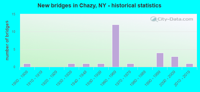
- New bridges - historical statistics
- 11900-1909
- 11930-1939
- 11940-1949
- 11950-1959
- 121960-1969
- 11970-1979
- 41990-1999
- 32000-2009
- 12010-2019


- Bridge Condition - Deck
- 6.3%Excellent
- 18.8%Very good
- 18.8%Good
- 18.8%Satisfactory
- 31.3%Fair
- 6.3%Poor

- Bridge Condition - Superstructure
- 11.1%Excellent
- 33.3%Very good
- 16.7%Good
- 33.3%Fair
- 5.6%Poor

- Bridge Condition - Substructure
- 5.6%Excellent
- 33.3%Very good
- 5.6%Good
- 22.2%Satisfactory
- 27.8%Fair
- 5.6%Poor

- Bridge Condition - Channel
- 7.1%Very good
- 42.9%Good
- 21.4%Satisfactory
- 28.6%Fair
Find on map >> Show street view
Structure Number: 100603, Location: IN TOWN OF CHAZY (Lat: 44.889678, Lng: -73.437314), Route carried "on" structure: State highway 9, Year Built: 1990, Status: Open, Structure Length: 2.04m (6.69ft), Average Daily Traffic: 3,554 (year 2020), Truck Traffic: 10%, Average Future Daily Traffic: 3,576 (year 2040), Design Load: HS 20, Features Intersected: LITTLE CHAZY RIVR
Minimum Vertical Clearance: 30+ m (98+ ft), Kilometerpoint: 41.432, Lanes on structure: 2, Base Highway Network: Yes, Owner: State Highway Agency, Approaching Roadway Width: 11.6m (38.1ft), Skew: 1 degrees, Material/Design: Prestressed concrete, Design/Construction: Box Beam or Girders - Multiple, Number Of Spans In Main Unit: 1, Length of Maximum Span: 18.8m (61.7ft), Curb or Sidewalk Widths: Left: 1.5m (4.9ft), Right: 1.5m (4.9ft), Curb-To-Curb Width: 11.6m (38.1ft), Out-to-Out Width: 15.6m (51.2ft)
Condition: Deck: Good, Superstructure: Very good, Substructure: Good, Channel: Good, Operating Rating: 89.8 metric tons, Method Used To Determine Operating Rating: Load Factor (LF), Inventory Rating: 53.5 metric tons, Method Used To Determine Inventory Rating: Load Factor (LF), Structural Evaluation: Better than present minimum criteria, Deck Geometry: Somewhat better than minimum adequacy, Waterway Adequacy: Equal to present minimum criteria, Approach Roadway Alignment: Equal to present desirable criteria, Length Of Structure Improvement: 2.04m (6.69ft), Designated Inspection Frequency: Every 24 months, Underwater Inspection Frequency: Every 60 months, Inspection Date: October 2020, Underwater Inspection Date: August 2019, Bridge Improvement Cost: $748,000, Roadway Improvement Cost: $438,000, Total Project Cost: $1,186,000 ( Estimate for 2021), Deck Structure Type: Concrete Cast-file-Place, Wearing Surface/Protective System: Wearing Surface: Integral Concrete, Deck Protection: Epoxy Coated Reinforcing
Find on map >> Show street view
Structure Number: 103406, Location: .2 MI W INT CR30 & CR25 (Lat: 44.818661, Lng: -73.447292), Route carried "on" structure: County highway , Year Built: 1960, Status: Open, Structure Length: 9.75m (31.99ft), Average Daily Traffic: 640 (year 2020), Truck Traffic: 10%, Average Future Daily Traffic: 896 (year 2040), Design Load: HS 20, Features Intersected: RTE I87, RTE I87, Facility Carried by Structure: STRATTON HILL RD
Minimum Vertical Clearance: 30+ m (98+ ft), Kilometerpoint: 3.958, Lanes on structure: 2, Lanes under structure: 4, Owner: State Highway Agency, Approaching Roadway Width: 7.3m (24.0ft), Skew: 1 degrees, Material/Design: Prestressed concrete, Design/Construction: Tee Beam, Number Of Spans In Main Unit: 6, Length of Maximum Span: 17.4m (57.1ft), Curb or Sidewalk Widths: Left: 0.5m (1.6ft), Right: 0.5m (1.6ft), Curb-To-Curb Width: 9.1m (29.9ft), Out-to-Out Width: 10.8m (35.4ft)
Condition: Deck: Fair, Superstructure: Fair, Substructure: Poor, Operating Rating: 80.4 metric tons, Method Used To Determine Operating Rating: Field evaluation and documented engineering judgment, Inventory Rating: 29.4 metric tons, Method Used To Determine Inventory Rating: Field evaluation and documented engineering judgment, Structural Evaluation: Meets minimum limits, Deck Geometry: Equal to present minimum criteria, Underclear: High priority of corrective action, Approach Roadway Alignment: Equal to present desirable criteria, Length Of Structure Improvement: 9.75m (31.99ft), Designated Inspection Frequency: Every 24 months, Inspection Date: August 2021, Bridge Improvement Cost: $1,494,000, Roadway Improvement Cost: $875,000, Total Project Cost: $2,369,000 ( Estimate for 2021), Deck Structure Type: Concrete Cast-file-Place, Wearing Surface/Protective System: Wearing Surface: Bituminous, Membrane: Other
Find on map >> Show street view
Structure Number: 1034071, Location: .2 MI S INT I87 & C R 24 (Lat: 44.860653, Lng: -73.452269), Route carried "on" structure: Interstate 87, Year Built: 1962, Status: Open, Structure Length: 1.04m (3.41ft), Average Daily Traffic: 4,800 (year 2008), Truck Traffic: 23%, Design Load: H 20, Features Intersected: LITTLE CHAZY RIVER
Minimum Vertical Clearance: 30+ m (98+ ft), Kilometerpoint: 43.894, Lanes on structure: 2, Base Highway Network: Yes, Owner: State Highway Agency, Approaching Roadway Width: 11.0m (36.1ft), Skew: 1 degrees, Material/Design: Concrete continuous, Design/Construction: Culvert, Number Of Spans In Main Unit: 2, Length of Maximum Span: 4.5m (14.8ft)
Condition: Channel: Satisfactory, Culverts: Good, Structural Evaluation: Better than present minimum criteria, Waterway Adequacy: Equal to present minimum criteria, Approach Roadway Alignment: Equal to present desirable criteria, Length Of Structure Improvement: 1.03m (3.38ft), Designated Inspection Frequency: Every 24 months, Inspection Date: April 2020, Bridge Improvement Cost: $228,000, Roadway Improvement Cost: $133,000, Total Project Cost: $361,000 ( Estimate for 2021), Wearing Surface/Protective System: Wearing Surface: Bituminous
Find on map >> Show street view
Structure Number: 1034072, Location: .2 MI S INT I87 & C R 24 (Lat: 44.868153, Lng: -73.450544), Route carried "on" structure: Interstate 87, Year Built: 1962, Status: Open, Structure Length: 0.98m (3.22ft), Average Daily Traffic: 2,323 (year 2016), Truck Traffic: 23%, Average Future Daily Traffic: 2,766 (year 2040), Design Load: HS 20, Features Intersected: LITT CHAZY RIVER
Minimum Vertical Clearance: 30+ m (98+ ft), Kilometerpoint: 44.923, Lanes on structure: 2, Base Highway Network: Yes, Owner: State Highway Agency, Approaching Roadway Width: 11.0m (36.1ft), Material/Design: Concrete continuous, Design/Construction: Culvert, Number Of Spans In Main Unit: 2, Length of Maximum Span: 4.5m (14.8ft)
Condition: Channel: Good, Culverts: Good, Structural Evaluation: Better than present minimum criteria, Waterway Adequacy: Equal to present desirable criteria, Approach Roadway Alignment: Equal to present desirable criteria, Length Of Structure Improvement: 0.97m (3.18ft), Designated Inspection Frequency: Every 24 months, Inspection Date: April 2020, Bridge Improvement Cost: $214,000, Roadway Improvement Cost: $125,000, Total Project Cost: $340,000 ( Estimate for 2021), Wearing Surface/Protective System: Wearing Surface: Bituminous
Find on map >> Show street view
Structure Number: 103408, Location: INT I87 & COUNTY ROAD 24 (Lat: 44.870256, Lng: -73.452531), Route carried "on" structure: County highway , Year Built: 1962, Status: Posted for load-capacity, Structure Length: 5.43m (17.81ft), Average Daily Traffic: 597 (year 2020), Truck Traffic: 12%, Average Future Daily Traffic: 622 (year 2040), Design Load: HS 20, Features Intersected: RTE I87, Facility Carried by Structure: CR24 (FISKE RD)
Minimum Vertical Clearance: 30+ m (98+ ft), Kilometerpoint: 13.870, Lanes on structure: 2, Lanes under structure: 2, Owner: State Highway Agency, Approaching Roadway Width: 7.3m (24.0ft), Skew: 3 degrees, Material/Design: Prestressed concrete, Design/Construction: Tee Beam, Number Of Spans In Main Unit: 3, Length of Maximum Span: 20.7m (67.9ft), Curb or Sidewalk Widths: Left: 0.5m (1.6ft), Right: 0.5m (1.6ft), Curb-To-Curb Width: 9.1m (29.9ft), Out-to-Out Width: 10.8m (35.4ft)
Condition: Deck: Fair, Superstructure: Fair, Substructure: Fair, Operating Rating: 82.4 metric tons, Method Used To Determine Operating Rating: Field evaluation and documented engineering judgment, Inventory Rating: 29.4 metric tons, Method Used To Determine Inventory Rating: Field evaluation and documented engineering judgment, Structural Evaluation: Somewhat better than minimum adequacy, Deck Geometry: Equal to present minimum criteria, Underclear: High priority of corrective action, Approach Roadway Alignment: Equal to present desirable criteria, Length Of Structure Improvement: 5.42m (17.78ft), Designated Inspection Frequency: Every 24 months, Inspection Date: July 2021, Bridge Improvement Cost: $932,000, Roadway Improvement Cost: $546,000, Total Project Cost: $1,477,000 ( Estimate for 2021), Deck Structure Type: Concrete Cast-file-Place, Wearing Surface/Protective System: Wearing Surface: Bituminous, Membrane: Other
Find on map >> Show street view
Structure Number: 103409, Location: JCT I87 & COUNTY ROAD 24 (Lat: 44.870781, Lng: -73.451317), Route carried "on" structure: County highway , Year Built: 1962, Status: Posted for load-capacity, Structure Length: 4.63m (15.19ft), Average Daily Traffic: 597 (year 2020), Truck Traffic: 12%, Average Future Daily Traffic: 622 (year 2040), Design Load: HS 20, Features Intersected: RTE I87, Facility Carried by Structure: CR24 (FISKE RD)
Minimum Vertical Clearance: 30+ m (98+ ft), Kilometerpoint: 13.966, Lanes on structure: 2, Lanes under structure: 2, Owner: State Highway Agency, Approaching Roadway Width: 7.3m (24.0ft), Skew: 2 degrees, Material/Design: Prestressed concrete, Design/Construction: Tee Beam, Number Of Spans In Main Unit: 3, Length of Maximum Span: 18.0m (59.1ft), Curb or Sidewalk Widths: Left: 0.5m (1.6ft), Right: 0.5m (1.6ft), Curb-To-Curb Width: 9.1m (29.9ft), Out-to-Out Width: 10.8m (35.4ft)
Condition: Deck: Fair, Superstructure: Fair, Substructure: Fair, Operating Rating: 81.9 metric tons, Method Used To Determine Operating Rating: Field evaluation and documented engineering judgment, Inventory Rating: 32.7 metric tons, Method Used To Determine Inventory Rating: Field evaluation and documented engineering judgment, Structural Evaluation: Somewhat better than minimum adequacy, Deck Geometry: Equal to present minimum criteria, Underclear: Somewhat better than minimum adequacy, Approach Roadway Alignment: Equal to present desirable criteria, Length Of Structure Improvement: 4.63m (15.19ft), Designated Inspection Frequency: Every 24 months, Inspection Date: July 2021, Bridge Improvement Cost: $743,000, Roadway Improvement Cost: $435,000, Total Project Cost: $1,178,000 ( Estimate for 2021), Deck Structure Type: Concrete Cast-file-Place, Wearing Surface/Protective System: Wearing Surface: Bituminous, Membrane: Other
Find on map >> Show street view
Structure Number: 1034101, Location: .4 MI S EXIT 41 OF I87 (Lat: 44.884261, Lng: -73.452222), Route carried "on" structure: Interstate 87, Year Built: 2003, Status: Open, Structure Length: 2.65m (8.69ft), Average Daily Traffic: 3,281 (year 2012), Truck Traffic: 28%, Design Load: HS 25 or greater, Features Intersected: DELAWARE & HUDSON
Minimum Vertical Clearance: 30+ m (98+ ft), Kilometerpoint: 58.310, Lanes on structure: 2, Base Highway Network: Yes, Owner: State Highway Agency, Approaching Roadway Width: 11.3m (37.1ft), Skew: 2 degrees, Material/Design: Steel, Design/Construction: Stringer/Multi-beam, Number Of Spans In Main Unit: 1, Length of Maximum Span: 25.0m (82.0ft), Curb-To-Curb Width: 11.4m (37.4ft), Out-to-Out Width: 12.4m (40.7ft)
Condition: Deck: Good, Superstructure: Very good, Substructure: Very good, Operating Rating: 61.2 metric tons, Method Used To Determine Operating Rating: Load and Resistance Factor Rating (LRFR) rating reported by rating factor(RF) method using HL-93 loadings, Inventory Rating: 47.3 metric tons, Method Used To Determine Inventory Rating: Load and Resistance Factor Rating (LRFR) rating reported by rating factor(RF) method using HL-93 loadings, Structural Evaluation: Equal to present desirable criteria, Deck Geometry: Somewhat better than minimum adequacy, Underclear: Equal to present minimum criteria, Approach Roadway Alignment: Equal to present desirable criteria, Length Of Structure Improvement: 2.65m (8.69ft), Designated Inspection Frequency: Every 24 months, Inspection Date: September 2021, Bridge Improvement Cost: $1,095,000, Roadway Improvement Cost: $641,000, Total Project Cost: $1,737,000 ( Estimate for 2021), Deck Structure Type: Concrete Cast-file-Place, Wearing Surface/Protective System: Wearing Surface: Integral Concrete, Deck Protection: Epoxy Coated Reinforcing
Find on map >> Show street view
Structure Number: 1034102, Location: .4 MI S EXIT 41 OF I87 (Lat: 44.884528, Lng: -73.451606), Route carried "on" structure: Interstate 87, Year Built: 2003, Status: Open, Structure Length: 2.65m (8.69ft), Average Daily Traffic: 2,323 (year 2016), Truck Traffic: 23%, Average Future Daily Traffic: 2,766 (year 2040), Design Load: HS 25 or greater, Features Intersected: DELAWARE & HUDSON
Minimum Vertical Clearance: 30+ m (98+ ft), Kilometerpoint: 46.741, Lanes on structure: 2, Base Highway Network: Yes, Owner: State Highway Agency, Approaching Roadway Width: 11.3m (37.1ft), Skew: 2 degrees, Material/Design: Steel, Design/Construction: Stringer/Multi-beam, Number Of Spans In Main Unit: 1, Length of Maximum Span: 25.0m (82.0ft), Curb-To-Curb Width: 11.4m (37.4ft), Out-to-Out Width: 12.4m (40.7ft)
Condition: Deck: Very good, Superstructure: Good, Substructure: Very good, Operating Rating: 61.2 metric tons, Method Used To Determine Operating Rating: Load and Resistance Factor Rating (LRFR) rating reported by rating factor(RF) method using HL-93 loadings, Inventory Rating: 47.3 metric tons, Method Used To Determine Inventory Rating: Load and Resistance Factor Rating (LRFR) rating reported by rating factor(RF) method using HL-93 loadings, Structural Evaluation: Better than present minimum criteria, Deck Geometry: Somewhat better than minimum adequacy, Underclear: Equal to present minimum criteria, Approach Roadway Alignment: Equal to present desirable criteria, Length Of Structure Improvement: 2.65m (8.69ft), Designated Inspection Frequency: Every 24 months, Inspection Date: September 2021, Bridge Improvement Cost: $1,109,000, Roadway Improvement Cost: $649,000, Total Project Cost: $1,758,000 ( Estimate for 2021), Deck Structure Type: Concrete Cast-file-Place, Wearing Surface/Protective System: Wearing Surface: Integral Concrete, Deck Protection: Epoxy Coated Reinforcing
Find on map >> Show street view
Structure Number: 103411, Location: AT I87 EXIT 41 (Lat: 44.889567, Lng: -73.453656), Route carried "on" structure: County highway 191, Year Built: 1962, Status: Posted for load-capacity, Structure Length: 9.60m (31.50ft), Average Daily Traffic: 2,024 (year 2020), Truck Traffic: 9%, Average Future Daily Traffic: 2,834 (year 2040), Design Load: HS 20, Features Intersected: RTE I87, RTE I87
Minimum Vertical Clearance: 30+ m (98+ ft), Kilometerpoint: 17.168, Lanes on structure: 2, Lanes under structure: 4, Base Highway Network: Yes, Owner: State Highway Agency, Approaching Roadway Width: 9.8m (32.2ft), Material/Design: Prestressed concrete, Design/Construction: Tee Beam, Number Of Spans In Main Unit: 6, Length of Maximum Span: 17.7m (58.1ft), Curb-To-Curb Width: 9.8m (32.2ft), Out-to-Out Width: 10.9m (35.8ft)
Condition: Deck: Fair, Superstructure: Fair, Substructure: Fair, Operating Rating: 77.9 metric tons, Method Used To Determine Operating Rating: Field evaluation and documented engineering judgment, Inventory Rating: 19.6 metric tons, Method Used To Determine Inventory Rating: Field evaluation and documented engineering judgment, Structural Evaluation: Somewhat better than minimum adequacy, Deck Geometry: Meets minimum limits, Underclear: High priority of corrective action, Approach Roadway Alignment: Equal to present desirable criteria, Length Of Structure Improvement: 9.60m (31.50ft), Designated Inspection Frequency: Every 24 months, Inspection Date: August 2021, Bridge Improvement Cost: $1,541,000, Roadway Improvement Cost: $902,000, Total Project Cost: $2,444,000 ( Estimate for 2021), Deck Structure Type: Concrete Cast-file-Place, Wearing Surface/Protective System: Wearing Surface: Bituminous, Membrane: Other
Find on map >> Show street view
Structure Number: 104625, Location: 1 MI NE OF WEST CHAZY (Lat: 44.827178, Lng: -73.492972), Route carried "on" structure: Alternate County highway , Year Built: 1993, Status: Open, Structure Length: 1.13m (3.71ft), Average Daily Traffic: 517 (year 2016), Truck Traffic: 7%, Average Future Daily Traffic: 539 (year 2040), Design Load: HS 25 or greater, Features Intersected: LITT CHAZY RIVER, Facility Carried by Structure: COUNTY ROAD 24
Minimum Vertical Clearance: 30+ m (98+ ft), Kilometerpoint: 7.820, Lanes on structure: 2, Owner: County Highway Agency, Approaching Roadway Width: 7.3m (24.0ft), Skew: 1 degrees, Material/Design: Prestressed concrete, Design/Construction: Box Beam or Girders - Multiple, Number Of Spans In Main Unit: 1, Length of Maximum Span: 10.6m (34.8ft), Curb-To-Curb Width: 7.3m (24.0ft), Out-to-Out Width: 7.9m (25.9ft)
Condition: Deck: Very good, Superstructure: Excellent, Substructure: Satisfactory, Channel: Very good, Operating Rating: 89.8 metric tons, Method Used To Determine Operating Rating: Load Factor (LF), Inventory Rating: 48.1 metric tons, Method Used To Determine Inventory Rating: Load Factor (LF), Structural Evaluation: Equal to present minimum criteria, Deck Geometry: Meets minimum limits, Waterway Adequacy: Equal to present minimum criteria, Approach Roadway Alignment: Equal to present desirable criteria, Length Of Structure Improvement: 1.12m (3.67ft), Designated Inspection Frequency: Every 24 months, Inspection Date: April 2020, Bridge Improvement Cost: $308,000, Roadway Improvement Cost: $180,000, Total Project Cost: $488,000 ( Estimate for 2021), Deck Structure Type: Concrete Cast-file-Place, Wearing Surface/Protective System: Wearing Surface: Integral Concrete, Deck Protection: Epoxy Coated Reinforcing
Find on map >> Show street view
Structure Number: 104626, Location: 100 FT SO US9 HMLET CHAZY (Lat: 44.885644, Lng: -73.435856), Route carried "on" structure: County highway , Year Built: 1995, Status: Open, Structure Length: 1.19m (3.90ft), Average Daily Traffic: 920 (year 2020), Truck Traffic: 9%, Average Future Daily Traffic: 959 (year 2040), Design Load: HS 25 or greater, Features Intersected: LITTLE CHAZY RIVR, Facility Carried by Structure: COUNTY ROAD 24
Minimum Vertical Clearance: 30+ m (98+ ft), Kilometerpoint: 16.122, Lanes on structure: 2, Owner: County Highway Agency, Approaching Roadway Width: 9.8m (32.2ft), Material/Design: Concrete, Design/Construction: Arch - Deck, Number Of Spans In Main Unit: 1, Length of Maximum Span: 10.9m (35.8ft), Curb or Sidewalk Widths: Left: 1.5m (4.9ft), Right: 1.5m (4.9ft), Curb-To-Curb Width: 9.8m (32.2ft), Out-to-Out Width: 13.4m (44.0ft)
Condition: Superstructure: Very good, Substructure: Very good, Channel: Fair, Operating Rating: 65.3 metric tons, Method Used To Determine Operating Rating: Load Factor (LF), Inventory Rating: 39.0 metric tons, Method Used To Determine Inventory Rating: Load Factor (LF), Structural Evaluation: Equal to present desirable criteria, Deck Geometry: Equal to present minimum criteria, Waterway Adequacy: Somewhat better than minimum adequacy, Approach Roadway Alignment: Equal to present desirable criteria, Length Of Structure Improvement: 1.18m (3.87ft), Designated Inspection Frequency: Every 24 months, Inspection Date: July 2021, Bridge Improvement Cost: $267,000, Roadway Improvement Cost: $157,000, Total Project Cost: $424,000 ( Estimate for 2021)
Find on map >> Show street view
Structure Number: 333608, Location: 1.2 MI N CHAZY LANDING (Lat: 44.904447, Lng: -73.382800), Route carried "on" structure: County highway , Year Built: 1964, Year Reconstructed: 2013, Status: Open, Structure Length: 2.53m (8.30ft), Average Daily Traffic: 452 (year 2015), Truck Traffic: 5%, Average Future Daily Traffic: 633 (year 2035), Design Load: HL 93, Features Intersected: LITT CHAZY RIVER, Facility Carried by Structure: LAKE SHORE ROAD
Minimum Vertical Clearance: 30+ m (98+ ft), Kilometerpoint: 18.439, Lanes on structure: 2, Owner: County Highway Agency, Approaching Roadway Width: 7.9m (25.9ft), Material/Design: Prestressed concrete, Design/Construction: Box Beam or Girders - Multiple, Number Of Spans In Main Unit: 1, Length of Maximum Span: 24.0m (78.7ft), Curb-To-Curb Width: 7.9m (25.9ft), Out-to-Out Width: 9.0m (29.5ft)
Condition: Deck: Very good, Superstructure: Excellent, Substructure: Very good, Channel: Good, Operating Rating: 81.6 metric tons, Method Used To Determine Operating Rating: Load Factor (LF), Inventory Rating: 33.6 metric tons, Method Used To Determine Inventory Rating: Load Factor (LF), Structural Evaluation: Equal to present desirable criteria, Deck Geometry: Somewhat better than minimum adequacy, Waterway Adequacy: Equal to present minimum criteria, Approach Roadway Alignment: Equal to present desirable criteria, Length Of Structure Improvement: 2.52m (8.27ft), Designated Inspection Frequency: Every 24 months, Inspection Date: August 2021, Bridge Improvement Cost: $486,000, Roadway Improvement Cost: $285,000, Total Project Cost: $771,000 ( Estimate for 2021), Deck Structure Type: Concrete Cast-file-Place, Wearing Surface/Protective System: Wearing Surface: Integral Concrete, Deck Protection: Epoxy Coated Reinforcing
Find on map >> Show street view
Structure Number: 33361, Location: 1.4 MI NE OF CHAZY (Lat: 44.901978, Lng: -73.415014), Route carried "on" structure: Other road , Year Built: 1971, Status: Open, Structure Length: 1.16m (3.81ft), Average Daily Traffic: 360 (year 2019), Truck Traffic: 17%, Average Future Daily Traffic: 504 (year 2039), Features Intersected: LITT CHAZY RIVER, Facility Carried by Structure: STETSON RD
Minimum Vertical Clearance: 30+ m (98+ ft), Kilometerpoint: 2.204, Lanes on structure: 2, Owner: County Highway Agency, Approaching Roadway Width: 6.7m (22.0ft), Material/Design: Steel, Design/Construction: Stringer/Multi-beam, Number Of Spans In Main Unit: 1, Length of Maximum Span: 10.9m (35.8ft), Curb-To-Curb Width: 9.4m (30.8ft), Out-to-Out Width: 9.8m (32.2ft)
Condition: Deck: Poor, Superstructure: Poor, Substructure: Satisfactory, Channel: Fair, Operating Rating: 25.3 metric tons, Method Used To Determine Operating Rating: Load and Resistance Factor Rating (LRFR) rating reported by rating factor(RF) method using HL-93 loadings, Inventory Rating: 19.4 metric tons, Method Used To Determine Inventory Rating: Load and Resistance Factor Rating (LRFR) rating reported by rating factor(RF) method using HL-93 loadings, Structural Evaluation: Meets minimum limits, Deck Geometry: Equal to present minimum criteria, Waterway Adequacy: Somewhat better than minimum adequacy, Approach Roadway Alignment: Equal to present minimum criteria, Length Of Structure Improvement: 1.15m (3.77ft), Designated Inspection Frequency: Every 24 months, Inspection Date: July 2021, Bridge Improvement Cost: $409,000, Roadway Improvement Cost: $239,000, Total Project Cost: $648,000 ( Estimate for 2021), Deck Structure Type: Open Grating, Wearing Surface/Protective System: Wearing Surface: Other
Find on map >> Show street view
Structure Number: 333611, Location: .6MI S CHAZY (Lat: 44.880658, Lng: -73.434303), Route carried "on" structure: Other road , Year Built: 1950, Status: Open, Structure Length: 1.80m (5.91ft), Average Daily Traffic: 265 (year 2020), Truck Traffic: 8%, Average Future Daily Traffic: 371 (year 2040), Features Intersected: LITTLE CHAZY RIVE, Facility Carried by Structure: DUPREY ROAD
Minimum Vertical Clearance: 30+ m (98+ ft), Kilometerpoint: 1.368, Lanes on structure: 2, Owner: County Highway Agency, Approaching Roadway Width: 5.5m (18.0ft), Material/Design: Steel, Design/Construction: Stringer/Multi-beam, Number Of Spans In Main Unit: 1, Length of Maximum Span: 17.0m (55.8ft), Curb or Sidewalk Widths: Left: 0.8m (2.6ft), Right: 0.8m (2.6ft), Curb-To-Curb Width: 7.3m (24.0ft), Out-to-Out Width: 9.8m (32.2ft)
Condition: Deck: Fair, Superstructure: Very good, Substructure: Fair, Channel: Satisfactory, Operating Rating: 46.3 metric tons, Method Used To Determine Operating Rating: Load Factor (LF), Inventory Rating: 27.2 metric tons, Method Used To Determine Inventory Rating: Load Factor (LF), Structural Evaluation: Somewhat better than minimum adequacy, Deck Geometry: Somewhat better than minimum adequacy, Waterway Adequacy: Somewhat better than minimum adequacy, Approach Roadway Alignment: Equal to present desirable criteria, Length Of Structure Improvement: 1.79m (5.87ft), Designated Inspection Frequency: Every 24 months, Underwater Inspection Frequency: Every 60 months, Inspection Date: September 2020, Underwater Inspection Date: August 2017, Bridge Improvement Cost: $524,000, Roadway Improvement Cost: $307,000, Total Project Cost: $830,000 ( Estimate for 2021), Deck Structure Type: Concrete Cast-file-Place, Wearing Surface/Protective System: Wearing Surface: Bituminous
Find on map >> Show street view
Structure Number: 333612, Location: 1.1 MI SW OF CHAZY (Lat: 44.874553, Lng: -73.441261), Route carried "on" structure: Other road , Year Built: 2000, Status: Open, Structure Length: 1.58m (5.18ft), Average Daily Traffic: 466 (year 2020), Truck Traffic: 4%, Average Future Daily Traffic: 652 (year 2040), Design Load: HS 25 or greater, Features Intersected: LITTL CHAZY RIVER, Facility Carried by Structure: RATTA ROAD
Minimum Vertical Clearance: 30+ m (98+ ft), Kilometerpoint: 6.339, Lanes on structure: 2, Owner: County Highway Agency, Approaching Roadway Width: 8.2m (26.9ft), Skew: 1 degrees, Material/Design: Prestressed concrete, Design/Construction: Box Beam or Girders - Multiple, Number Of Spans In Main Unit: 1, Length of Maximum Span: 15.2m (49.9ft), Curb-To-Curb Width: 8.2m (26.9ft), Out-to-Out Width: 9.1m (29.9ft)
Condition: Deck: Satisfactory, Superstructure: Very good, Substructure: Very good, Channel: Good, Operating Rating: 71.7 metric tons, Method Used To Determine Operating Rating: Load Factor (LF), Inventory Rating: 42.6 metric tons, Method Used To Determine Inventory Rating: Load Factor (LF), Structural Evaluation: Equal to present desirable criteria, Deck Geometry: Somewhat better than minimum adequacy, Waterway Adequacy: Equal to present minimum criteria, Approach Roadway Alignment: Equal to present desirable criteria, Length Of Structure Improvement: 1.58m (5.18ft), Designated Inspection Frequency: Every 24 months, Inspection Date: September 2020, Bridge Improvement Cost: $460,000, Roadway Improvement Cost: $269,000, Total Project Cost: $729,000 ( Estimate for 2021), Deck Structure Type: Concrete Cast-file-Place, Wearing Surface/Protective System: Wearing Surface: Integral Concrete, Deck Protection: Epoxy Coated Reinforcing
Find on map >> Show street view
Structure Number: 333615, Location: 2.8MI NE WEST CHAZY (Lat: 44.845714, Lng: -73.461850), Route carried "on" structure: Other road , Year Built: 1940, Status: Open, Structure Length: 1.17m (3.84ft), Average Daily Traffic: 146 (year 2020), Truck Traffic: 3%, Average Future Daily Traffic: 204 (year 2040), Features Intersected: LITTLE CHAZY RIVE, Facility Carried by Structure: SLOSSON ROAD
Minimum Vertical Clearance: 30+ m (98+ ft), Kilometerpoint: 6.243, Lanes on structure: 2, Owner: County Highway Agency, Approaching Roadway Width: 5.5m (18.0ft), Material/Design: Steel, Design/Construction: Stringer/Multi-beam, Number Of Spans In Main Unit: 1, Length of Maximum Span: 11.2m (36.7ft), Curb-To-Curb Width: 7.3m (24.0ft), Out-to-Out Width: 7.9m (25.9ft)
Condition: Deck: Satisfactory, Superstructure: Good, Substructure: Satisfactory, Channel: Good, Operating Rating: 45.4 metric tons, Method Used To Determine Operating Rating: Load Factor (LF), Inventory Rating: 27.2 metric tons, Method Used To Determine Inventory Rating: Load Factor (LF), Structural Evaluation: Equal to present minimum criteria, Deck Geometry: Somewhat better than minimum adequacy, Waterway Adequacy: Somewhat better than minimum adequacy, Approach Roadway Alignment: Better than present minimum criteria, Length Of Structure Improvement: 1.17m (3.84ft), Designated Inspection Frequency: Every 24 months, Inspection Date: August 2020, Bridge Improvement Cost: $318,000, Roadway Improvement Cost: $186,000, Total Project Cost: $505,000 ( Estimate for 2021), Deck Structure Type: Concrete Cast-file-Place, Wearing Surface/Protective System: Wearing Surface: Bituminous
Find on map >> Show street view
Structure Number: 333616, Location: 2.6MI NE WEST CHAZY (Lat: 44.846453, Lng: -73.469072), Route carried "on" structure: Other road , Year Built: 1962, Status: Open, Structure Length: 1.01m (3.31ft), Average Daily Traffic: 210 (year 2020), Truck Traffic: 7%, Average Future Daily Traffic: 294 (year 2040), Features Intersected: LITTLE CHAZY RIVE, Facility Carried by Structure: ASHLEY ROAD
Minimum Vertical Clearance: 30+ m (98+ ft), Kilometerpoint: 4.714, Lanes on structure: 2, Owner: County Highway Agency, Approaching Roadway Width: 6.4m (21.0ft), Skew: 1 degrees, Material/Design: Concrete, Design/Construction: Channel Beam, Number Of Spans In Main Unit: 1, Length of Maximum Span: 9.4m (30.8ft), Curb or Sidewalk Widths: Left: 0.8m (2.6ft), Right: 0.8m (2.6ft), Curb-To-Curb Width: 7.9m (25.9ft), Out-to-Out Width: 10.2m (33.5ft)
Condition: Deck: Satisfactory, Superstructure: Fair, Substructure: Satisfactory, Channel: Good, Operating Rating: 40.8 metric tons, Method Used To Determine Operating Rating: Load Factor (LF), Inventory Rating: 20.9 metric tons, Method Used To Determine Inventory Rating: Load Factor (LF), Structural Evaluation: Somewhat better than minimum adequacy, Deck Geometry: Somewhat better than minimum adequacy, Waterway Adequacy: Somewhat better than minimum adequacy, Approach Roadway Alignment: Equal to present minimum criteria, Length Of Structure Improvement: 1.00m (3.28ft), Designated Inspection Frequency: Every 24 months, Inspection Date: August 2020, Bridge Improvement Cost: $867,000, Roadway Improvement Cost: $508,000, Total Project Cost: $1,375,000 ( Estimate for 2021), Wearing Surface/Protective System: Wearing Surface: Bituminous
Find on map >> Show street view
Structure Number: 333617, Location: 3.5 MI NE OF WEST CHAZY (Lat: 44.844775, Lng: -73.470681), Route carried "on" structure: Other road , Year Built: 2010, Status: Open, Structure Length: 1.34m (4.40ft), Average Daily Traffic: 146 (year 2020), Truck Traffic: 3%, Average Future Daily Traffic: 204 (year 2040), Design Load: HL 93, Features Intersected: LITT CHAZY RIVER, Facility Carried by Structure: SLOSSON ROAD
Minimum Vertical Clearance: 30+ m (98+ ft), Kilometerpoint: 5.535, Lanes on structure: 2, Owner: County Highway Agency, Approaching Roadway Width: 6.1m (20.0ft), Skew: 1 degrees, Material/Design: Concrete, Design/Construction: Frame, Number Of Spans In Main Unit: 1, Length of Maximum Span: 12.2m (40.0ft), Curb-To-Curb Width: 8.4m (27.6ft), Out-to-Out Width: 9.4m (30.8ft)
Condition: Deck: Excellent, Superstructure: Very good, Substructure: Excellent, Channel: Fair, Operating Rating: 94.3 metric tons, Method Used To Determine Operating Rating: Load Factor (LF), Inventory Rating: 56.2 metric tons, Method Used To Determine Inventory Rating: Load Factor (LF), Structural Evaluation: Equal to present desirable criteria, Deck Geometry: Somewhat better than minimum adequacy, Waterway Adequacy: Equal to present minimum criteria, Approach Roadway Alignment: Equal to present desirable criteria, Length Of Structure Improvement: 1.34m (4.40ft), Designated Inspection Frequency: Every 24 months, Inspection Date: August 2020, Bridge Improvement Cost: $323,000, Roadway Improvement Cost: $189,000, Total Project Cost: $512,000 ( Estimate for 2021), Wearing Surface/Protective System: Wearing Surface: Bituminous, Membrane: Other
Find on map >> Show street view
Structure Number: 333619, Location: .7 MI W OF WEST CHAZY (Lat: 44.820439, Lng: -73.510114), Route carried "on" structure: County highway , Year Built: 1909, Status: Open, Structure Length: 1.01m (3.31ft), Average Daily Traffic: 1,098 (year 2016), Truck Traffic: 5%, Average Future Daily Traffic: 1,537 (year 2036), Features Intersected: LITTLE CHAZY RVR, Facility Carried by Structure: CR 25
Minimum Vertical Clearance: 30+ m (98+ ft), Kilometerpoint: 5.953, Lanes on structure: 2, Owner: County Highway Agency, Approaching Roadway Width: 9.8m (32.2ft), Material/Design: Concrete, Design/Construction: Arch - Deck, Number Of Spans In Main Unit: 1, Length of Maximum Span: 9.1m (29.9ft), Curb or Sidewalk Widths: Left: 3.8m (12.5ft), Right: 4.1m (13.5ft), Curb-To-Curb Width: 9.8m (32.2ft), Out-to-Out Width: 17.8m (58.4ft)
Condition: Superstructure: Fair, Substructure: Fair, Channel: Fair, Operating Rating: 44.9 metric tons, Method Used To Determine Operating Rating: Field evaluation and documented engineering judgment, Inventory Rating: 12.8 metric tons, Method Used To Determine Inventory Rating: Field evaluation and documented engineering judgment, Structural Evaluation: Meets minimum limits, Deck Geometry: Somewhat better than minimum adequacy, Waterway Adequacy: Meets minimum limits, Approach Roadway Alignment: Equal to present desirable criteria, Length Of Structure Improvement: 1.00m (3.28ft), Designated Inspection Frequency: Every 24 months, Inspection Date: September 2020, Bridge Improvement Cost: $301,000, Roadway Improvement Cost: $176,000, Total Project Cost: $477,000 ( Estimate for 2021), Wearing Surface/Protective System: Wearing Surface: Bituminous
Find on map >> Show street view
Structure Number: 336922, Location: .8 MI W JCT SH 22 & CR 24 (Lat: 44.818997, Lng: -73.523572), Route carried "on" structure: County highway , Year Built: 1996, Status: Open, Structure Length: 0.82m (2.69ft), Average Daily Traffic: 1,098 (year 2016), Truck Traffic: 5%, Average Future Daily Traffic: 1,537 (year 2036), Design Load: HS 20, Features Intersected: LITTL CHAZY RIVER, Facility Carried by Structure: CR25,W.Church St.
Minimum Vertical Clearance: 30+ m (98+ ft), Kilometerpoint: 5.969, Lanes on structure: 2, Owner: County Highway Agency, Approaching Roadway Width: 8.5m (27.9ft), Skew: 4 degrees, Material/Design: Concrete, Design/Construction: Frame, Number Of Spans In Main Unit: 1, Length of Maximum Span: 7.9m (25.9ft), Curb-To-Curb Width: 8.5m (27.9ft), Out-to-Out Width: 9.6m (31.5ft)
Condition: Deck: Good, Superstructure: Good, Substructure: Very good, Channel: Satisfactory, Operating Rating: 63.5 metric tons, Method Used To Determine Operating Rating: Load Factor (LF), Inventory Rating: 38.1 metric tons, Method Used To Determine Inventory Rating: Load Factor (LF), Structural Evaluation: Better than present minimum criteria, Deck Geometry: Somewhat better than minimum adequacy, Waterway Adequacy: Meets minimum limits, Approach Roadway Alignment: Equal to present desirable criteria, Length Of Structure Improvement: 0.82m (2.69ft), Designated Inspection Frequency: Every 24 months, Inspection Date: September 2020, Bridge Improvement Cost: $158,000, Roadway Improvement Cost: $93,000, Total Project Cost: $251,000 ( Estimate for 2021), Wearing Surface/Protective System: Wearing Surface: Bituminous, Membrane: Other
Find on map >> Show street view
Structure Number: 103406, Location: .2 MI W INT CR30 & CR25 (Lat: 44.818661, Lng: -73.447292), Route carried "under" structure: Interstate 87, Year Built: 1960, Structure Length: 0. m, Average Daily Traffic: 3,397 (year 1988), Features Intersected: RTE I87, RTE I87, Facility Carried by Structure: STRATTON HILL RD
Minimum Vertical Clearance: 4.95m (16.24ft), Kilometerpoint: 39.597, Lanes on structure: 2, Lanes under structure: 2, Material/Design: Prestressed concrete, Design/Construction: Tee Beam, Length of Maximum Span: 17.4m (57.1ft)
Find on map >> Show street view
Structure Number: 103408, Location: INT I87 & COUNTY ROAD 24 (Lat: 44.870256, Lng: -73.452531), Route carried "under" structure: Interstate 87, Year Built: 1962, Structure Length: 0. m, Average Daily Traffic: 147,078 (year 1999), Features Intersected: RTE I87, Facility Carried by Structure: CR24 (FISKE RD)
Minimum Vertical Clearance: 5.10m (16.73ft), Kilometerpoint: 45.052, Lanes on structure: 2, Lanes under structure: 2, Material/Design: Prestressed concrete, Design/Construction: Tee Beam, Length of Maximum Span: 20.7m (67.9ft)
Find on map >> Show street view
Structure Number: 103409, Location: JCT I87 & COUNTY ROAD 24 (Lat: 44.870781, Lng: -73.451317), Route carried "under" structure: State highway 87, Year Built: 1962, Structure Length: 0. m, Average Daily Traffic: 147,078 (year 1999), Features Intersected: RTE I87, Facility Carried by Structure: CR24 (FISKE RD)
Minimum Vertical Clearance: 5.00m (16.40ft), Kilometerpoint: 45.052, Lanes on structure: 2, Lanes under structure: 2, Material/Design: Prestressed concrete, Design/Construction: Tee Beam, Length of Maximum Span: 18.0m (59.1ft)
Find on map >> Show street view
Structure Number: 103411, Location: AT I87 EXIT 41 (Lat: 44.889567, Lng: -73.453656), Route carried "under" structure: Interstate 87, Year Built: 1962, Structure Length: 0. m, Average Daily Traffic: 1 (year 1971), Features Intersected: RTE I87, RTE I87, Facility Carried by Structure: RTE 191
Minimum Vertical Clearance: 5.00m (16.40ft), Kilometerpoint: 47.562, Lanes on structure: 2, Lanes under structure: 2, Material/Design: Prestressed concrete, Design/Construction: Tee Beam, Length of Maximum Span: 17.7m (58.1ft)
Find on map >> Show street view
Structure Number: 700604, Location: .25 MI N OF CHAZY (Lat: 44.893219, Lng: -73.437033), Route carried "under" structure: US 9, Year Built: 1934, Structure Length: 0. m, Average Daily Traffic: 3,488 (year 1999), Features Intersected: RTE 9, Facility Carried by Structure: DELAWARE & HUDSON
Minimum Vertical Clearance: 4.36m (14.30ft), Kilometerpoint: 20.563, Lanes under structure: 2, Material/Design: Steel, Design/Construction: Girder and Floorbeam System, Length of Maximum Span: 33.8m (110.9ft)