Bridge Statistics for Chateaugay, New York (NY)
Condition, Traffic, Stress, Structural Evaluation, Project Costs
- National Bridge Inventory (NBI) Statistics
- 11Number of bridges
- 125ft / 37.6mTotal length
- $12,249,000Total costs
- 10,008Total average daily traffic
- 2,038Total average daily truck traffic
- 10,482Total future (year 2034) average daily traffic
- National Bridge Inventory (NBI) Registered Bridges for Chateaugay
- No street view available for this location
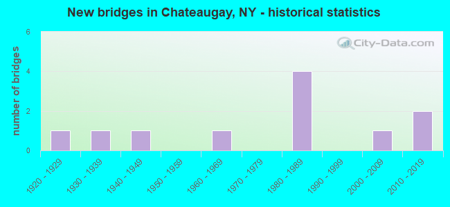
- New bridges - historical statistics
- 11920-1929
- 11930-1939
- 11940-1949
- 11960-1969
- 41980-1989
- 12000-2009
- 22010-2019

- Reconstructed bridges - Historical Statistics
- 11990-1999
- 02000-2009
- 22010-2019


- Bridge Condition - Deck
- 14.3%Excellent
- 42.9%Very good
- 28.6%Good
- 14.3%Poor

- Bridge Condition - Superstructure
- 57.1%Very good
- 28.6%Good
- 14.3%Poor

- Bridge Condition - Substructure
- 42.9%Very good
- 42.9%Good
- 14.3%Fair

- Bridge Condition - Channel
- 9.1%Excellent
- 27.3%Very good
- 27.3%Good
- 9.1%Satisfactory
- 18.2%Fair
- 9.1%Poor

- Bridge Condition - Culverts
- 75.0%Good
- 25.0%Serious
Find on map >> Show street view
Structure Number: 100897, Location: JCT RTE 11 &CHATEAUGAY R (Lat: 44.925550, Lng: -74.094425), Route carried "on" structure: State highway 11, Year Built: 1989, Year Reconstructed: 2016, Status: Open, Structure Length: 23.16m (75.98ft), Average Daily Traffic: 4,769 (year 2016), Truck Traffic: 23%, Average Future Daily Traffic: 4,814 (year 2040), Design Load: HS 20, Features Intersected: CHATEAUGAY RIVER
Minimum Vertical Clearance: 30+ m (98+ ft), Kilometerpoint: 46.983, Lanes on structure: 2, Base Highway Network: Yes, Owner: State Highway Agency, Approaching Roadway Width: 12.2m (40.0ft), Material/Design: Steel continuous, Design/Construction: Stringer/Multi-beam, Number Of Spans In Main Unit: 7, Length of Maximum Span: 42.6m (139.8ft), Curb-To-Curb Width: 11.8m (38.7ft), Out-to-Out Width: 12.8m (42.0ft)
Condition: Deck: Good, Superstructure: Good, Substructure: Good, Channel: Very good, Operating Rating: 68.0 metric tons, Method Used To Determine Operating Rating: Allowable Stress (AS), Inventory Rating: 36.3 metric tons, Method Used To Determine Inventory Rating: Allowable Stress (AS), Structural Evaluation: Better than present minimum criteria, Deck Geometry: Somewhat better than minimum adequacy, Waterway Adequacy: Equal to present minimum criteria, Approach Roadway Alignment: Equal to present desirable criteria, Length Of Structure Improvement: 23.16m (75.98ft), Designated Inspection Frequency: Every 24 months, Inspection Date: September 2020, Bridge Improvement Cost: $5,198,000, Roadway Improvement Cost: $3,044,000, Total Project Cost: $8,242,000 ( Estimate for 2021), Deck Structure Type: Concrete Cast-file-Place, Wearing Surface/Protective System: Wearing Surface: Integral Concrete, Deck Protection: Epoxy Coated Reinforcing
Find on map >> Show street view
Structure Number: 100898, Location: 0.3 MI E JCT US 11 + SH 3 (Lat: 44.926936, Lng: -74.071169), Route carried "on" structure: US 11, Year Built: 1937, Status: Open, Structure Length: 0.88m (2.89ft), Average Daily Traffic: 3,809 (year 2018), Truck Traffic: 20%, Average Future Daily Traffic: 3,845 (year 2040), Design Load: H 20, Features Intersected: BOARDMAN BROOK
Minimum Vertical Clearance: 30+ m (98+ ft), Kilometerpoint: 48.962, Lanes on structure: 2, Base Highway Network: Yes, Owner: State Highway Agency, Approaching Roadway Width: 12.2m (40.0ft), Skew: 5 degrees, Material/Design: Concrete, Design/Construction: Culvert, Number Of Spans In Main Unit: 1, Length of Maximum Span: 8.5m (27.9ft)
Condition: Channel: Good, Culverts: Good, Operating Rating: 68.1 metric tons, Method Used To Determine Operating Rating: Field evaluation and documented engineering judgment, Inventory Rating: 29.4 metric tons, Method Used To Determine Inventory Rating: Field evaluation and documented engineering judgment, Structural Evaluation: Better than present minimum criteria, Waterway Adequacy: Equal to present minimum criteria, Approach Roadway Alignment: Equal to present desirable criteria, Length Of Structure Improvement: 0.88m (2.89ft), Designated Inspection Frequency: Every 24 months, Inspection Date: April 2020, Bridge Improvement Cost: $216,000, Roadway Improvement Cost: $126,000, Total Project Cost: $342,000 ( Estimate for 2021), Wearing Surface/Protective System: Wearing Surface: Bituminous
Find on map >> Show street view
Structure Number: 106014, Location: 1 MI N INT US11 & NY374 (Lat: 44.940175, Lng: -74.080925), Route carried "on" structure: County highway 374, Year Built: 1922, Year Reconstructed: 1997, Status: Open, Structure Length: 0.98m (3.22ft), Average Daily Traffic: 496 (year 2016), Truck Traffic: 24%, Average Future Daily Traffic: 517 (year 2040), Design Load: HS 20, Features Intersected: MARBLE RIVER
Minimum Vertical Clearance: 30+ m (98+ ft), Kilometerpoint: 1.512, Lanes on structure: 2, Base Highway Network: Yes, Owner: County Highway Agency, Approaching Roadway Width: 9.1m (29.9ft), Material/Design: Concrete, Design/Construction: Culvert, Number Of Spans In Main Unit: 1, Length of Maximum Span: 9.4m (30.8ft)
Condition: Channel: Fair, Culverts: Good, Operating Rating: 79.3 metric tons, Method Used To Determine Operating Rating: Field evaluation and documented engineering judgment, Inventory Rating: 32.7 metric tons, Method Used To Determine Inventory Rating: Field evaluation and documented engineering judgment, Structural Evaluation: Better than present minimum criteria, Waterway Adequacy: Meets minimum limits, Approach Roadway Alignment: Equal to present minimum criteria, Length Of Structure Improvement: 0.97m (3.18ft), Designated Inspection Frequency: Every 24 months, Inspection Date: May 2021, Bridge Improvement Cost: $179,000, Roadway Improvement Cost: $105,000, Total Project Cost: $283,000 ( Estimate for 2021)
Find on map >> Show street view
Structure Number: 221972, Location: 1 MILE WEST OF ROUTE 374 (Lat: 44.981842, Lng: -74.105094), Route carried "on" structure: Other road , Year Built: 1989, Status: Open, Structure Length: 0.67m (2.20ft), Average Daily Traffic: 58 (year 2015), Truck Traffic: 7%, Average Future Daily Traffic: 81 (year 2035), Features Intersected: COLLINS BROOK, Facility Carried by Structure: SANDY KNOLL ROAD
Minimum Vertical Clearance: 30+ m (98+ ft), Kilometerpoint: 2.735, Lanes on structure: 2, Owner: Town or Township Highway Agency, Approaching Roadway Width: 4.3m (14.1ft), Material/Design: Steel, Design/Construction: Culvert, Number Of Spans In Main Unit: 3, Length of Maximum Span: 1.8m (5.9ft)
Condition: Channel: Poor, Culverts: Serious, Operating Rating: 73.0 metric tons, Method Used To Determine Operating Rating: Field evaluation and documented engineering judgment, Inventory Rating: 13.1 metric tons, Method Used To Determine Inventory Rating: Field evaluation and documented engineering judgment, Structural Evaluation: High priority of corrective action, Waterway Adequacy: Meets minimum limits, Approach Roadway Alignment: Meets minimum limits, Length Of Structure Improvement: 0.67m (2.20ft), Designated Inspection Frequency: Every 12 months, Inspection Date: May 2021, Bridge Improvement Cost: $57,000, Roadway Improvement Cost: $34,000, Total Project Cost: $91,000 ( Estimate for 2021)
Find on map >> Show street view
Structure Number: 221973, Location: 3.4 MI NE OF CHATEAUGAY (Lat: 44.970456, Lng: -74.048408), Route carried "on" structure: Other road , Year Built: 1985, Status: Closed, Structure Length: 0.76m (2.49ft), Average Daily Traffic: 147 (year 2017), Truck Traffic: 7%, Average Future Daily Traffic: 206 (year 2037), Features Intersected: HINCHIN BROOK, Facility Carried by Structure: MCCORMICK ROAD
Minimum Vertical Clearance: 30+ m (98+ ft), Kilometerpoint: 2.735, Lanes on structure: 1, Owner: County Highway Agency, Approaching Roadway Width: 4.9m (16.1ft), Skew: 1 degrees, Material/Design: Steel, Design/Construction: Stringer/Multi-beam, Number Of Spans In Main Unit: 1, Length of Maximum Span: 7.0m (23.0ft), Curb-To-Curb Width: 4.6m (15.1ft), Out-to-Out Width: 5.9m (19.4ft)
Condition: Deck: Poor, Superstructure: Poor, Substructure: Fair, Channel: Fair, Waterway Adequacy: Somewhat better than minimum adequacy, Approach Roadway Alignment: High priority of corrective action, Bridge Posting: Required (Relationship of Operating Rating to Maximum Legal Load: > 39.9% below), Length Of Structure Improvement: 0.76m (2.49ft), Designated Inspection Frequency: Every 24 months, Inspection Date: June 2021, Bridge Improvement Cost: $157,000, Roadway Improvement Cost: $92,000, Total Project Cost: $249,000 ( Estimate for 2021), Deck Structure Type: Wood or Timber, Wearing Surface/Protective System: Wearing Surface: Bituminous
Find on map >> Show street view
Structure Number: 333763, Location: 3.1MI N THAYER CORNERS (Lat: 44.962922, Lng: -74.131964), Route carried "on" structure: Other road , Year Built: 1949, Year Reconstructed: 2015, Status: Open, Structure Length: 2.16m (7.09ft), Average Daily Traffic: 41 (year 2020), Truck Traffic: 7%, Average Future Daily Traffic: 57 (year 2040), Design Load: HS 20, Features Intersected: CHATEAUGAY RIVER, Facility Carried by Structure: SAM COOK ROAD
Minimum Vertical Clearance: 30+ m (98+ ft), Kilometerpoint: 0.467, Lanes on structure: 2, Owner: County Highway Agency, Approaching Roadway Width: 4.3m (14.1ft), Material/Design: Steel, Design/Construction: Stringer/Multi-beam, Number Of Spans In Main Unit: 1, Length of Maximum Span: 20.1m (65.9ft), Curb-To-Curb Width: 5.5m (18.0ft), Out-to-Out Width: 6.6m (21.7ft)
Condition: Deck: Excellent, Superstructure: Very good, Substructure: Good, Channel: Satisfactory, Operating Rating: 80.7 metric tons, Method Used To Determine Operating Rating: Load Factor (LF), Inventory Rating: 48.1 metric tons, Method Used To Determine Inventory Rating: Load Factor (LF), Structural Evaluation: Better than present minimum criteria, Deck Geometry: Meets minimum limits, Waterway Adequacy: Somewhat better than minimum adequacy, Approach Roadway Alignment: Meets minimum limits, Length Of Structure Improvement: 2.16m (7.09ft), Designated Inspection Frequency: Every 24 months, Inspection Date: August 2021, Bridge Improvement Cost: $453,000, Roadway Improvement Cost: $265,000, Total Project Cost: $718,000 ( Estimate for 2021), Deck Structure Type: Concrete Cast-file-Place, Wearing Surface/Protective System: Wearing Surface: Integral Concrete, Deck Protection: Epoxy Coated Reinforcing
Find on map >> Show street view
Structure Number: 333764, Location: 1.7 MI NE OF THAYER CORNE (Lat: 44.940911, Lng: -74.125183), Route carried "on" structure: Other road , Year Built: 1969, Status: Open, Structure Length: 1.10m (3.61ft), Truck Traffic: 7%, Features Intersected: CHATEAUGAY RIVER, Facility Carried by Structure: BRAYTON HOLLOW RD
Minimum Vertical Clearance: 30+ m (98+ ft), Kilometerpoint: 0.338, Lanes on structure: 1, Owner: County Highway Agency, Approaching Roadway Width: 2.7m (8.9ft), Material/Design: Steel, Design/Construction: Stringer/Multi-beam, Number Of Spans In Main Unit: 1, Length of Maximum Span: 9.7m (31.8ft), Curb-To-Curb Width: 3.6m (11.8ft), Out-to-Out Width: 4.2m (13.8ft)
Condition: Deck: Good, Superstructure: Good, Substructure: Good, Channel: Good, Operating Rating: 63.5 metric tons, Method Used To Determine Operating Rating: Load Factor (LF), Inventory Rating: 38.1 metric tons, Method Used To Determine Inventory Rating: Load Factor (LF), Structural Evaluation: Better than present minimum criteria, Deck Geometry: High priority of corrective action, Waterway Adequacy: Equal to present desirable criteria, Approach Roadway Alignment: High priority of replacement, Length Of Structure Improvement: 1.09m (3.58ft), Designated Inspection Frequency: Every 24 months, Critical Feature Inspection Frequency: Every 24 months, Inspection Date: July 2020, Critical Feature Inspection Date: July 2020, Bridge Improvement Cost: $156,000, Roadway Improvement Cost: $91,000, Total Project Cost: $247,000 ( Estimate for 2021), Deck Structure Type: Open Grating, Wearing Surface/Protective System: Wearing Surface: Other
Find on map >> Show street view
Structure Number: 333765, Location: 1 MI SW OF CHATEAUGAY (Lat: 44.906522, Lng: -74.087861), Route carried "on" structure: Other road , Year Built: 2011, Status: Open, Structure Length: 3.90m (12.80ft), Average Daily Traffic: 275 (year 2014), Truck Traffic: 7%, Average Future Daily Traffic: 385 (year 2034), Design Load: HL 93, Features Intersected: CHATEAUGAY RIVER, Facility Carried by Structure: PULP MILL ROAD
Minimum Vertical Clearance: 30+ m (98+ ft), Kilometerpoint: 0.161, Lanes on structure: 2, Owner: County Highway Agency, Approaching Roadway Width: 7.6m (24.9ft), Skew: 3 degrees, Material/Design: Steel, Design/Construction: Stringer/Multi-beam, Number Of Spans In Main Unit: 1, Length of Maximum Span: 37.5m (123.0ft), Curb-To-Curb Width: 7.3m (24.0ft), Out-to-Out Width: 8.3m (27.2ft)
Condition: Deck: Very good, Superstructure: Very good, Substructure: Very good, Channel: Very good, Operating Rating: 49.9 metric tons, Method Used To Determine Operating Rating: Load and Resistance Factor Rating (LRFR) rating reported by rating factor(RF) method using HL-93 loadings, Inventory Rating: 38.2 metric tons, Method Used To Determine Inventory Rating: Load and Resistance Factor Rating (LRFR) rating reported by rating factor(RF) method using HL-93 loadings, Structural Evaluation: Equal to present desirable criteria, Deck Geometry: Somewhat better than minimum adequacy, Waterway Adequacy: Better than present minimum criteria, Approach Roadway Alignment: Equal to present desirable criteria, Length Of Structure Improvement: 3.90m (12.80ft), Designated Inspection Frequency: Every 24 months, Inspection Date: June 2021, Bridge Improvement Cost: $712,000, Roadway Improvement Cost: $417,000, Total Project Cost: $1,128,000 ( Estimate for 2021), Deck Structure Type: Concrete Cast-file-Place, Wearing Surface/Protective System: Wearing Surface: Integral Concrete, Deck Protection: Epoxy Coated Reinforcing
Find on map >> Show street view
Structure Number: 333791, Location: 2.6 MI NE OF THAYER CRNRS (Lat: 44.959150, Lng: -74.129114), Route carried "on" structure: County highway , Year Built: 2003, Status: Open, Structure Length: 1.65m (5.41ft), Average Daily Traffic: 71 (year 2020), Truck Traffic: 7%, Average Future Daily Traffic: 99 (year 2040), Design Load: HS 25 or greater, Features Intersected: MARBLE RIVER, Facility Carried by Structure: COUNTY ROAD 35
Minimum Vertical Clearance: 30+ m (98+ ft), Kilometerpoint: 5.792, Lanes on structure: 2, Owner: County Highway Agency, Approaching Roadway Width: 6.7m (22.0ft), Material/Design: Prestressed concrete, Design/Construction: Box Beam or Girders - Multiple, Number Of Spans In Main Unit: 1, Length of Maximum Span: 16.0m (52.5ft), Curb-To-Curb Width: 6.6m (21.7ft), Out-to-Out Width: 7.5m (24.6ft)
Condition: Deck: Very good, Superstructure: Very good, Substructure: Very good, Channel: Very good, Operating Rating: 73.6 metric tons, Method Used To Determine Operating Rating: Load Factor (LF), Inventory Rating: 44.1 metric tons, Method Used To Determine Inventory Rating: Load Factor (LF), Structural Evaluation: Equal to present desirable criteria, Deck Geometry: Somewhat better than minimum adequacy, Waterway Adequacy: Equal to present minimum criteria, Approach Roadway Alignment: Equal to present desirable criteria, Length Of Structure Improvement: 1.64m (5.38ft), Designated Inspection Frequency: Every 24 months, Inspection Date: October 2021, Bridge Improvement Cost: $253,000, Roadway Improvement Cost: $148,000, Total Project Cost: $401,000 ( Estimate for 2021), Wearing Surface/Protective System: Wearing Surface: Bituminous, Membrane: Other
Find on map >> Show street view
Structure Number: 333822, Location: 0.5 MI NE OF CHATEAUGAY (Lat: 44.936447, Lng: -74.062294), Route carried "on" structure: County highway , Year Built: 1981, Status: Open, Structure Length: 1.10m (3.61ft), Average Daily Traffic: 301 (year 2020), Truck Traffic: 7%, Average Future Daily Traffic: 421 (year 2040), Design Load: HS 20, Features Intersected: MARBLE RIVER, Facility Carried by Structure: EARLVILLE ROAD
Minimum Vertical Clearance: 30+ m (98+ ft), Kilometerpoint: 1.303, Lanes on structure: 2, Owner: County Highway Agency, Approaching Roadway Width: 7.6m (24.9ft), Skew: 4 degrees, Material/Design: Steel, Design/Construction: Culvert, Number Of Spans In Main Unit: 1, Length of Maximum Span: 10.6m (34.8ft)
Condition: Channel: Good, Culverts: Good, Operating Rating: 80.2 metric tons, Method Used To Determine Operating Rating: Field evaluation and documented engineering judgment, Inventory Rating: 32.7 metric tons, Method Used To Determine Inventory Rating: Field evaluation and documented engineering judgment, Structural Evaluation: Better than present minimum criteria, Waterway Adequacy: Meets minimum limits, Approach Roadway Alignment: Equal to present desirable criteria, Length Of Structure Improvement: 1.09m (3.58ft), Designated Inspection Frequency: Every 24 months, Inspection Date: July 2020, Bridge Improvement Cost: $167,000, Roadway Improvement Cost: $98,000, Total Project Cost: $266,000 ( Estimate for 2021), Wearing Surface/Protective System: Wearing Surface: Bituminous
Find on map >> Show street view
Structure Number: 337123, Location: 0.2 Mi West of Simms RD (Lat: 44.962761, Lng: -74.132931), Route carried "on" structure: Other road , Year Built: 2015, Status: Open, Structure Length: 1.22m (4.00ft), Average Daily Traffic: 41 (year 2020), Truck Traffic: 7%, Average Future Daily Traffic: 57 (year 2040), Design Load: HL 93, Features Intersected: Tributary of Chateaugay, Facility Carried by Structure: Sam Cook Road
Minimum Vertical Clearance: 30+ m (98+ ft), Kilometerpoint: 0.402, Lanes on structure: 2, Owner: County Highway Agency, Approaching Roadway Width: 4.0m (13.1ft), Material/Design: Steel, Design/Construction: Stringer/Multi-beam, Number Of Spans In Main Unit: 1, Length of Maximum Span: 11.6m (38.1ft), Curb-To-Curb Width: 5.5m (18.0ft), Out-to-Out Width: 6.2m (20.3ft)
Condition: Deck: Very good, Superstructure: Very good, Substructure: Very good, Channel: Excellent, Operating Rating: 55.3 metric tons, Method Used To Determine Operating Rating: Load Factor (LF), Inventory Rating: 32.7 metric tons, Method Used To Determine Inventory Rating: Load Factor (LF), Structural Evaluation: Equal to present desirable criteria, Deck Geometry: Meets minimum limits, Waterway Adequacy: Equal to present minimum criteria, Approach Roadway Alignment: Equal to present minimum criteria, Length Of Structure Improvement: 1.21m (3.97ft), Designated Inspection Frequency: Every 24 months, Inspection Date: August 2021, Bridge Improvement Cost: $178,000, Roadway Improvement Cost: $104,000, Total Project Cost: $282,000 ( Estimate for 2021), Deck Structure Type: Wood or Timber, Wearing Surface/Protective System: Wearing Surface: Bituminous