Bridge Statistics for Buena Park, California (CA)
Condition, Traffic, Stress, Structural Evaluation, Project Costs
- National Bridge Inventory (NBI) Statistics
- 41Number of bridges
- 423ft / 129mTotal length
- $13,705,000Total costs
- 3,034,840Total average daily traffic
- 160,107Total average daily truck traffic
- National Bridge Inventory (NBI) Registered Bridges for Buena Park
- No street view available for this location
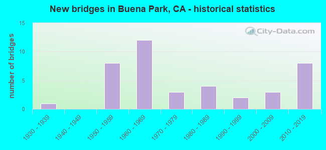
- New bridges - historical statistics
- 11930-1939
- 81950-1959
- 121960-1969
- 31970-1979
- 41980-1989
- 21990-1999
- 32000-2009
- 82010-2019

- Reconstructed bridges - Historical Statistics
- 11950-1959
- 21960-1969
- 11970-1979
- 01980-1989
- 31990-1999
- 12000-2009


- Bridge Condition - Deck
- 56.0%Good
- 44.0%Fair

- Bridge Condition - Superstructure
- 76.0%Good
- 20.0%Fair
- 4.0%Serious

- Bridge Condition - Substructure
- 4.0%Very good
- 80.0%Good
- 16.0%Fair

- Bridge Condition - Channel
- 47.1%Excellent
- 47.1%Very good
- 5.9%Good
Find on map >> Show street view
Structure Number: 55 008, Location: 12-ORA-090-1.23-LHB (Lat: 33.917214, Lng: -117.954944), Route carried "on" structure: State highway 90, Year Built: 1968, Status: Open, Structure Length: 0.85m (2.79ft), Average Daily Traffic: 47,000 (year 2011), Truck Traffic: 7%, Average Future Daily Traffic: 53,300 (year 2038), Design Load: HS 20, Features Intersected: IMPERIAL CHANNEL
Minimum Vertical Clearance: 30+ m (98+ ft), Kilometerpoint: 1.230, Lanes on structure: 6, Base Highway Network: Yes (, Subroute: 1), Owner: State Highway Agency, Approaching Roadway Width: 25.9m (85.0ft), Skew: 3 degrees, Material/Design: Concrete, Design/Construction: Culvert, Number Of Spans In Main Unit: 2, Length of Maximum Span: 4.3m (14.1ft), Curb or Sidewalk Widths: Left: 2.4m (7.9ft), Right: 0.6m (2.0ft), Curb-To-Curb Width: 25.9m (85.0ft), Out-to-Out Width: 26.9m (88.3ft)
Condition: Channel: Very good, Culverts: Good, Operating Rating: 54.1 metric tons, Method Used To Determine Operating Rating: Field evaluation and documented engineering judgment, Inventory Rating: 32.4 metric tons, Method Used To Determine Inventory Rating: Field evaluation and documented engineering judgment, Structural Evaluation: Better than present minimum criteria, Deck Geometry: Equal to present minimum criteria, Waterway Adequacy: Equal to present desirable criteria, Approach Roadway Alignment: Equal to present desirable criteria, Designated Inspection Frequency: Every 48 months, Inspection Date: April 2021
Find on map >> Show street view
Structure Number: 55 0087R, Location: 12-ORA-005-42.96-BPK (Lat: 33.862817, Lng: -117.991056), Route carried "on" structure: Interstate 5, Year Built: 1957, Year Reconstructed: 2011, Status: Open, Structure Length: 2.33m (7.64ft), Average Daily Traffic: 95,850 (year 2016), Truck Traffic: 7%, Average Future Daily Traffic: 111,500 (year 2038), Design Load: HS 20, Features Intersected: FULLERTON CREEK
Minimum Vertical Clearance: 30+ m (98+ ft), Kilometerpoint: 42.960, Lanes on structure: 8, Base Highway Network: Yes (, Subroute: 1), Owner: State Highway Agency, Approaching Roadway Width: 40.5m (132.9ft), Skew: 3 degrees, Material/Design: Concrete continuous, Design/Construction: Slab, Number Of Spans In Main Unit: 3, Length of Maximum Span: 8.8m (28.9ft), Curb-To-Curb Width: 40.5m (132.9ft), Out-to-Out Width: 41.3m (135.5ft)
Condition: Deck: Good, Superstructure: Good, Substructure: Good, Channel: Very good, Operating Rating: 54.1 metric tons, Method Used To Determine Operating Rating: Assigned rating based on Load Factor Design (LFD) reported in metric tons, Inventory Rating: 32.4 metric tons, Method Used To Determine Inventory Rating: Assigned rating based on Load Factor Design (LFD) reported in metric tons, Structural Evaluation: Better than present minimum criteria, Deck Geometry: Superior to present desirable criteria, Waterway Adequacy: Equal to present desirable criteria, Approach Roadway Alignment: Equal to present desirable criteria, Designated Inspection Frequency: Every 48 months, Inspection Date: Febuary 2020, Deck Structure Type: Concrete Cast-file-Place, Wearing Surface/Protective System: Wearing Surface: Integral Concrete
Find on map >> Show street view
Structure Number: 55 0159, Location: 12-ORA-039-13.51-BPK (Lat: 33.843342, Lng: -117.997061), Route carried "on" structure: State highway 39, Year Built: 1960, Status: Open, Structure Length: 0.79m (2.59ft), Average Daily Traffic: 59,000 (year 2011), Truck Traffic: 3%, Average Future Daily Traffic: 75,246 (year 2042), Design Load: HS 20, Features Intersected: PARKING LOT ACCESS
Minimum Vertical Clearance: 30+ m (98+ ft), Kilometerpoint: 13.510, Lanes on structure: 8, Base Highway Network: Yes (, Subroute: 1), Owner: State Highway Agency, Maintenance Responsibility: Private, Approaching Roadway Width: 28.8m (94.5ft), Skew: 20 degrees, Material/Design: Concrete continuous, Design/Construction: Slab, Number Of Spans In Main Unit: 2, Length of Maximum Span: 4.6m (15.1ft), Curb or Sidewalk Widths: Left: 0.0m, Right: 1.5m (4.9ft), Curb-To-Curb Width: 28.8m (94.5ft), Out-to-Out Width: 35.3m (115.8ft)
Condition: Deck: Good, Superstructure: Good, Substructure: Good, Operating Rating: 50.2 metric tons, Method Used To Determine Operating Rating: Load Factor (LF), Inventory Rating: 30.1 metric tons, Method Used To Determine Inventory Rating: Load Factor (LF), Structural Evaluation: Better than present minimum criteria, Deck Geometry: High priority of corrective action, Approach Roadway Alignment: Equal to present desirable criteria, Designated Inspection Frequency: Every 24 months, Inspection Date: January 2022, Deck Structure Type: Concrete Cast-file-Place, Wearing Surface/Protective System: Wearing Surface: Bituminous
Find on map >> Show street view
Structure Number: 55 0290F, Location: 12-ORA-133-8.59-IRVN (Lat: 33.654633, Lng: -117.759950), Route carried "on" structure: Ramp State highway 133, Year Built: 1968, Status: Open, Structure Length: 4.60m (15.09ft), Average Daily Traffic: 13,722 (year 2015), Truck Traffic: 3%, Average Future Daily Traffic: 14,299 (year 2037), Design Load: HS 20+Mod, Features Intersected: SAN DIEGO CREEK
Minimum Vertical Clearance: 30+ m (98+ ft), Kilometerpoint: 8.590, Lanes on structure: 1, Owner: State Highway Agency, Approaching Roadway Width: 7.3m (24.0ft), Material/Design: Concrete continuous, Design/Construction: Slab, Number Of Spans In Main Unit: 5, Length of Maximum Span: 9.1m (29.9ft), Curb-To-Curb Width: 7.3m (24.0ft), Out-to-Out Width: 8.3m (27.2ft)
Condition: Deck: Good, Superstructure: Good, Substructure: Fair, Channel: Good, Operating Rating: 54.1 metric tons, Method Used To Determine Operating Rating: Load Factor (LF), Inventory Rating: 32.4 metric tons, Method Used To Determine Inventory Rating: Load Factor (LF), Structural Evaluation: Somewhat better than minimum adequacy, Deck Geometry: Better than present minimum criteria, Waterway Adequacy: Better than present minimum criteria, Approach Roadway Alignment: Equal to present desirable criteria, Designated Inspection Frequency: Every 24 months, Inspection Date: November 2020, Deck Structure Type: Concrete Cast-file-Place
Find on map >> Show street view
Structure Number: 55 0299, Location: 12-ORA-091-R2.35-BPK (Lat: 33.855811, Lng: -118.002678), Route carried "on" structure: State highway 91, Year Built: 1969, Year Reconstructed: 1998, Status: Open, Structure Length: 3.96m (12.99ft), Average Daily Traffic: 265,000 (year 2012), Truck Traffic: 6%, Average Future Daily Traffic: 295,000 (year 2040), Design Load: HS 20, Features Intersected: WESTERN AVE
Minimum Vertical Clearance: 30+ m (98+ ft), Kilometerpoint: 2.350, Lanes on structure: 12, Lanes under structure: 5, Base Highway Network: Yes (, Subroute: 1), Owner: State Highway Agency, Approaching Roadway Width: 53.7m (176.2ft), Skew: 30 degrees, Material/Design: Prestressed concrete, Design/Construction: Box Beam or Girders - Multiple, Number Of Spans In Main Unit: 1, Length of Maximum Span: 39.0m (128.0ft), Curb-To-Curb Width: 53.7m (176.2ft), Out-to-Out Width: 55.3m (181.4ft)
Condition: Deck: Fair, Superstructure: Good, Substructure: Good, Operating Rating: 54.1 metric tons, Method Used To Determine Operating Rating: Assigned rating based on Load Factor Design (LFD) reported in metric tons, Inventory Rating: 32.4 metric tons, Method Used To Determine Inventory Rating: Assigned rating based on Load Factor Design (LFD) reported in metric tons, Structural Evaluation: Better than present minimum criteria, Deck Geometry: Superior to present desirable criteria, Underclear: Meets minimum limits, Approach Roadway Alignment: Equal to present desirable criteria, Designated Inspection Frequency: Every 24 months, Inspection Date: December 2020, Deck Structure Type: Concrete Cast-file-Place
Find on map >> Show street view
Structure Number: 55 03, Location: 12-ORA-091-R1.85-BPK (Lat: 33.855733, Lng: -118.011478), Route carried "on" structure: State highway 91, Year Built: 1969, Year Reconstructed: 1998, Status: Open, Structure Length: 4.51m (14.80ft), Average Daily Traffic: 265,000 (year 2012), Truck Traffic: 6%, Average Future Daily Traffic: 295,000 (year 2040), Design Load: HS 20, Features Intersected: KNOTT AVE
Minimum Vertical Clearance: 30+ m (98+ ft), Kilometerpoint: 1.850, Lanes on structure: 12, Lanes under structure: 6, Base Highway Network: Yes (, Subroute: 1), Owner: State Highway Agency, Approaching Roadway Width: 52.5m (172.2ft), Skew: 30 degrees, Material/Design: Prestressed concrete, Design/Construction: Box Beam or Girders - Multiple, Number Of Spans In Main Unit: 1, Length of Maximum Span: 44.5m (146.0ft), Curb-To-Curb Width: 52.5m (172.2ft), Out-to-Out Width: 54.1m (177.5ft)
Condition: Deck: Fair, Superstructure: Good, Substructure: Fair, Operating Rating: 54.1 metric tons, Method Used To Determine Operating Rating: Assigned rating based on Load Factor Design (LFD) reported in metric tons, Inventory Rating: 32.4 metric tons, Method Used To Determine Inventory Rating: Assigned rating based on Load Factor Design (LFD) reported in metric tons, Structural Evaluation: Somewhat better than minimum adequacy, Deck Geometry: Superior to present desirable criteria, Underclear: Meets minimum limits, Approach Roadway Alignment: Equal to present desirable criteria, Designated Inspection Frequency: Every 24 months, Inspection Date: December 2020, Deck Structure Type: Concrete Cast-file-Place
Find on map >> Show street view
Structure Number: 55 0302, Location: 12-ORA-091-R0.85-BPK (Lat: 33.857017, Lng: -118.028764), Route carried "on" structure: County highway , Year Built: 1969, Status: Open, Structure Length: 6.34m (20.80ft), Average Daily Traffic: 30,000 (year 2012), Truck Traffic: 7%, Average Future Daily Traffic: 33,000 (year 2040), Design Load: HS 20, Features Intersected: STATE ROUTE 91, Facility Carried by Structure: VALLEY VIEW ST
Minimum Vertical Clearance: 30+ m (98+ ft), Kilometerpoint: 0.000, Lanes on structure: 5, Lanes under structure: 11, Owner: State Highway Agency, Approaching Roadway Width: 22.9m (75.1ft), Skew: 32 degrees, Material/Design: Prestressed concrete continuous, Design/Construction: Box Beam or Girders - Multiple, Number Of Spans In Main Unit: 2, Length of Maximum Span: 32.6m (107.0ft), Curb or Sidewalk Widths: Left: 2.1m (6.9ft), Right: 0.0m, Curb-To-Curb Width: 22.9m (75.1ft), Out-to-Out Width: 27.1m (88.9ft)
Condition: Deck: Fair, Superstructure: Fair, Substructure: Good, Operating Rating: 54.1 metric tons, Method Used To Determine Operating Rating: Assigned rating based on Load Factor Design (LFD) reported in metric tons, Inventory Rating: 32.4 metric tons, Method Used To Determine Inventory Rating: Assigned rating based on Load Factor Design (LFD) reported in metric tons, Structural Evaluation: Somewhat better than minimum adequacy, Deck Geometry: Equal to present minimum criteria, Underclear: High priority of corrective action, Approach Roadway Alignment: Equal to present desirable criteria, Designated Inspection Frequency: Every 24 months, Inspection Date: December 2020, Deck Structure Type: Concrete Cast-file-Place
Find on map >> Show street view
Structure Number: 55 0303, Location: 12-ORA-091-R2.61-BPK (Lat: 33.855811, Lng: -117.998333), Route carried "on" structure: State highway 91, Year Built: 1970, Year Reconstructed: 1998, Status: Open, Structure Length: 5.73m (18.80ft), Average Daily Traffic: 265,000 (year 2012), Truck Traffic: 6%, Average Future Daily Traffic: 295,000 (year 2040), Design Load: HS 20, Features Intersected: ROUTE 39 (BEACH BLVD)
Minimum Vertical Clearance: 30+ m (98+ ft), Kilometerpoint: 2.610, Lanes on structure: 12, Lanes under structure: 8, Base Highway Network: Yes (, Subroute: 1), Owner: State Highway Agency, Approaching Roadway Width: 54.9m (180.1ft), Skew: 30 degrees, Material/Design: Prestressed concrete continuous, Design/Construction: Stringer/Multi-beam, Number Of Spans In Main Unit: 2, Length of Maximum Span: 28.3m (92.8ft), Curb-To-Curb Width: 54.9m (180.1ft), Out-to-Out Width: 56.5m (185.4ft)
Condition: Deck: Good, Superstructure: Good, Substructure: Good, Operating Rating: 33.4 metric tons, Method Used To Determine Operating Rating: Load and Resistance Factor Rating (LRFR) rating reported by rating factor(RF) method using HL-93 loadings, Inventory Rating: 13.3 metric tons, Method Used To Determine Inventory Rating: Load and Resistance Factor Rating (LRFR) rating reported by rating factor(RF) method using HL-93 loadings, Structural Evaluation: High priority of corrective action, Deck Geometry: Superior to present desirable criteria, Underclear: Meets minimum limits, Approach Roadway Alignment: Equal to present desirable criteria, Designated Inspection Frequency: Every 24 months, Inspection Date: December 2020, Deck Structure Type: Concrete Cast-file-Place
Find on map >> Show street view
Structure Number: 55 0836, Location: 12-ORA-005-42.54-BPK (Lat: 33.858947, Lng: -117.986747), Route carried "on" structure: City street , Year Built: 2003, Status: Open, Structure Length: 27.04m (88.71ft), Average Daily Traffic: 24,000 (year 2015), Truck Traffic: 3%, Average Future Daily Traffic: 25,897 (year 2042), Design Load: HS 20+Mod, Features Intersected: INTERSTATE 5, UP RR, Facility Carried by Structure: ORANGETHORPE AVE
Minimum Vertical Clearance: 30+ m (98+ ft), Kilometerpoint: 0.000, Lanes on structure: 6, Lanes under structure: 14, Owner: State Highway Agency, Approaching Roadway Width: 19.5m (64.0ft), Skew: 6 degrees, Material/Design: Prestressed concrete continuous, Design/Construction: Box Beam or Girders - Multiple, Number Of Spans In Main Unit: 3, Length of Maximum Span: 98.7m (323.8ft), Curb or Sidewalk Widths: Left: 2.4m (7.9ft), Right: 2.4m (7.9ft), Curb-To-Curb Width: 19.5m (64.0ft), Out-to-Out Width: 30.2m (99.1ft)
Condition: Deck: Good, Superstructure: Serious, Substructure: Good, Operating Rating: 36.6 metric tons, Method Used To Determine Operating Rating: Load and Resistance Factor Rating (LRFR) rating reported by rating factor(RF) method using HL-93 loadings, Inventory Rating: 28.2 metric tons, Method Used To Determine Inventory Rating: Load and Resistance Factor Rating (LRFR) rating reported by rating factor(RF) method using HL-93 loadings, Structural Evaluation: High priority of corrective action, Deck Geometry: High priority of replacement, Underclear: Meets minimum limits, Approach Roadway Alignment: Equal to present desirable criteria, Length Of Structure Improvement: 27.04m (88.71ft), Designated Inspection Frequency: Every 24 months, Inspection Date: Febuary 2022, Bridge Improvement Cost: $8,158,000, Roadway Improvement Cost: $1,631,000, Total Project Cost: $13,705,000 ( Estimate for 2017), Deck Structure Type: Concrete Cast-file-Place
Find on map >> Show street view
Structure Number: 55 1069, Location: 12-ORA-005-43.13 (Lat: 33.863494, Lng: -117.993667), Route carried "on" structure: City street , Year Built: 2010, Status: Open, Structure Length: 7.66m (25.13ft), Average Daily Traffic: 15,000 (year 2017), Truck Traffic: 2%, Average Future Daily Traffic: 26,018 (year 2042), Design Load: HS 20+Mod, Features Intersected: INTERSTATE 5, RAMPS, Facility Carried by Structure: STANTON AVE
Minimum Vertical Clearance: 30+ m (98+ ft), Kilometerpoint: 0.000, Lanes on structure: 4, Lanes under structure: 13, Owner: State Highway Agency, Approaching Roadway Width: 20.4m (66.9ft), Skew: 3 degrees, Material/Design: Concrete continuous, Design/Construction: Box Beam or Girders - Multiple, Number Of Spans In Main Unit: 2, Length of Maximum Span: 40.2m (131.9ft), Curb or Sidewalk Widths: Left: 2.4m (7.9ft), Right: 2.4m (7.9ft), Curb-To-Curb Width: 20.4m (66.9ft), Out-to-Out Width: 25.8m (84.6ft)
Condition: Deck: Fair, Superstructure: Good, Substructure: Good, Operating Rating: 54.1 metric tons, Method Used To Determine Operating Rating: Assigned rating based on Load Factor Design (LFD) reported in metric tons, Inventory Rating: 32.4 metric tons, Method Used To Determine Inventory Rating: Assigned rating based on Load Factor Design (LFD) reported in metric tons, Structural Evaluation: Better than present minimum criteria, Deck Geometry: Superior to present desirable criteria, Underclear: Equal to present minimum criteria, Approach Roadway Alignment: Equal to present desirable criteria, Designated Inspection Frequency: Every 24 months, Inspection Date: Febuary 2022, Deck Structure Type: Concrete Cast-file-Place
Find on map >> Show street view
Structure Number: 55 1071, Location: 12-ORA-005-43.70 (Lat: 33.868231, Lng: -118.002458), Route carried "on" structure: City street , Year Built: 2010, Status: Open, Structure Length: 8.84m (29.00ft), Average Daily Traffic: 20,000 (year 2017), Truck Traffic: 3%, Average Future Daily Traffic: 22,489 (year 2042), Design Load: HS 20+Mod, Features Intersected: INTERSTATE 5, RAMPS, Facility Carried by Structure: WESTERN AVENUE
Minimum Vertical Clearance: 30+ m (98+ ft), Kilometerpoint: 0.000, Lanes on structure: 4, Lanes under structure: 12, Owner: State Highway Agency, Approaching Roadway Width: 19.5m (64.0ft), Skew: 3 degrees, Material/Design: Concrete continuous, Design/Construction: Box Beam or Girders - Multiple, Number Of Spans In Main Unit: 2, Length of Maximum Span: 47.7m (156.5ft), Curb or Sidewalk Widths: Left: 2.7m (8.9ft), Right: 2.7m (8.9ft), Curb-To-Curb Width: 19.5m (64.0ft), Out-to-Out Width: 25.5m (83.7ft)
Condition: Deck: Fair, Superstructure: Fair, Substructure: Fair, Operating Rating: 54.1 metric tons, Method Used To Determine Operating Rating: Assigned rating based on Load Factor Design (LFD) reported in metric tons, Inventory Rating: 32.4 metric tons, Method Used To Determine Inventory Rating: Assigned rating based on Load Factor Design (LFD) reported in metric tons, Structural Evaluation: Somewhat better than minimum adequacy, Deck Geometry: Better than present minimum criteria, Underclear: Equal to present minimum criteria, Approach Roadway Alignment: Equal to present desirable criteria, Designated Inspection Frequency: Every 24 months, Inspection Date: Febuary 2022, Deck Structure Type: Concrete Cast-file-Place
Find on map >> Show street view
Structure Number: 55 1072, Location: 12-ORA-039-15.06 (Lat: 33.865858, Lng: -117.997836), Route carried "on" structure: State highway 39, Year Built: 2010, Status: Open, Structure Length: 7.74m (25.39ft), Average Daily Traffic: 51,000 (year 2011), Truck Traffic: 2%, Average Future Daily Traffic: 62,549 (year 2042), Design Load: HS 20+Mod, Features Intersected: INTERSTATE 5, RAMPS
Minimum Vertical Clearance: 30+ m (98+ ft), Kilometerpoint: 15.060, Lanes on structure: 6, Lanes under structure: 12, Base Highway Network: Yes (, Subroute: 1), Owner: State Highway Agency, Approaching Roadway Width: 40.3m (132.2ft), Skew: 3 degrees, Material/Design: Concrete continuous, Design/Construction: Box Beam or Girders - Multiple, Number Of Spans In Main Unit: 2, Length of Maximum Span: 41.0m (134.5ft), Curb or Sidewalk Widths: Left: 1.5m (4.9ft), Right: 1.5m (4.9ft), Curb-To-Curb Width: 40.3m (132.2ft), Out-to-Out Width: 43.9m (144.0ft)
Condition: Deck: Fair, Superstructure: Good, Substructure: Good, Operating Rating: 54.1 metric tons, Method Used To Determine Operating Rating: Assigned rating based on Load Factor Design (LFD) reported in metric tons, Inventory Rating: 32.4 metric tons, Method Used To Determine Inventory Rating: Assigned rating based on Load Factor Design (LFD) reported in metric tons, Structural Evaluation: Better than present minimum criteria, Deck Geometry: Superior to present desirable criteria, Underclear: Meets minimum limits, Approach Roadway Alignment: Equal to present desirable criteria, Designated Inspection Frequency: Every 24 months, Inspection Date: January 2022, Deck Structure Type: Concrete Cast-file-Place
Find on map >> Show street view
Structure Number: 55 1073L, Location: 12-ORA-005-42.98 (Lat: 33.862714, Lng: -117.991556), Route carried "on" structure: Interstate 5, Year Built: 2010, Status: Open, Structure Length: 2.82m (9.25ft), Average Daily Traffic: 95,850 (year 2016), Truck Traffic: 9%, Average Future Daily Traffic: 116,817 (year 2042), Design Load: HS 20+Mod, Features Intersected: FULLERTON CREEK
Minimum Vertical Clearance: 30+ m (98+ ft), Kilometerpoint: 42.980, Lanes on structure: 6, Base Highway Network: Yes (, Subroute: 1), Owner: State Highway Agency, Approaching Roadway Width: 28.5m (93.5ft), Skew: 4 degrees, Material/Design: Prestressed concrete continuous, Design/Construction: Slab, Number Of Spans In Main Unit: 3, Length of Maximum Span: 15.5m (50.9ft), Curb-To-Curb Width: 28.5m (93.5ft), Out-to-Out Width: 29.6m (97.1ft)
Condition: Deck: Fair, Superstructure: Fair, Substructure: Good, Channel: Very good, Operating Rating: 54.1 metric tons, Method Used To Determine Operating Rating: Assigned rating based on Load Factor Design (LFD) reported in metric tons, Inventory Rating: 32.4 metric tons, Method Used To Determine Inventory Rating: Assigned rating based on Load Factor Design (LFD) reported in metric tons, Structural Evaluation: Somewhat better than minimum adequacy, Deck Geometry: Better than present minimum criteria, Waterway Adequacy: Equal to present desirable criteria, Approach Roadway Alignment: Equal to present desirable criteria, Designated Inspection Frequency: Every 24 months, Inspection Date: Febuary 2022, Deck Structure Type: Concrete Cast-file-Place
Find on map >> Show street view
Structure Number: 55C0034, Location: 0.4 MI. S/O DEL OBISPO ST (Lat: 33.491925, Lng: -117.662725), Route carried "on" structure: City street , Year Built: 1987, Status: Open, Structure Length: 8.72m (28.61ft), Average Daily Traffic: 20,400 (year 2016), Truck Traffic: 1%, Average Future Daily Traffic: 42,753 (year 2040), Design Load: HS 20+Mod, Features Intersected: SAN JUAN CREEK CHANNEL, Facility Carried by Structure: CAMINO CAPISTRANO
Minimum Vertical Clearance: 30+ m (98+ ft), Kilometerpoint: 0.000, Lanes on structure: 4, Owner: City or Municipal Highway Agency, Approaching Roadway Width: 20.6m (67.6ft), Skew: 34 degrees, Material/Design: Prestressed concrete continuous, Design/Construction: Box Beam or Girders - Multiple, Number Of Spans In Main Unit: 2, Length of Maximum Span: 41.1m (134.8ft), Curb or Sidewalk Widths: Left: 1.5m (4.9ft), Right: 3.6m (11.8ft), Curb-To-Curb Width: 20.6m (67.6ft), Out-to-Out Width: 27.7m (90.9ft)
Condition: Deck: Fair, Superstructure: Good, Substructure: Good, Channel: Very good, Operating Rating: 54.1 metric tons, Method Used To Determine Operating Rating: Assigned rating based on Load Factor Design (LFD) reported in metric tons, Inventory Rating: 32.4 metric tons, Method Used To Determine Inventory Rating: Assigned rating based on Load Factor Design (LFD) reported in metric tons, Structural Evaluation: Better than present minimum criteria, Deck Geometry: Superior to present desirable criteria, Waterway Adequacy: Equal to present desirable criteria, Approach Roadway Alignment: Equal to present desirable criteria, Designated Inspection Frequency: Every 24 months, Inspection Date: October 2020, Deck Structure Type: Concrete Cast-file-Place
Find on map >> Show street view
Structure Number: 55C0039R, Location: 0.9 MI. N/O ORANGETHORPE (Lat: 33.870875, Lng: -118.028617), Route carried "on" structure: City street , Year Built: 1967, Status: Open, Structure Length: 5.12m (16.80ft), Average Daily Traffic: 36,000 (year 2020), Truck Traffic: 5%, Average Future Daily Traffic: 75,183 (year 2040), Design Load: HS 20, Features Intersected: COYOTE CREEK CHANNEL, Facility Carried by Structure: N/B VALLEY VIEW ST
Minimum Vertical Clearance: 30+ m (98+ ft), Kilometerpoint: 0.000, Lanes on structure: 3, Base Highway Network: Yes, Owner: City or Municipal Highway Agency, Approaching Roadway Width: 13.1m (43.0ft), Material/Design: Concrete continuous, Design/Construction: Tee Beam, Number Of Spans In Main Unit: 3, Length of Maximum Span: 20.1m (65.9ft), Curb or Sidewalk Widths: Left: 0.6m (2.0ft), Right: 0.6m (2.0ft), Curb-To-Curb Width: 11.4m (37.4ft), Out-to-Out Width: 13.3m (43.6ft)
Condition: Deck: Good, Superstructure: Good, Substructure: Very good, Channel: Excellent, Operating Rating: 69.7 metric tons, Method Used To Determine Operating Rating: Load Factor (LF), Inventory Rating: 41.8 metric tons, Method Used To Determine Inventory Rating: Load Factor (LF), Structural Evaluation: Better than present minimum criteria, Deck Geometry: High priority of replacement, Waterway Adequacy: Superior to present desirable criteria, Approach Roadway Alignment: Equal to present desirable criteria, Designated Inspection Frequency: Every 48 months, Inspection Date: April 2020, Deck Structure Type: Concrete Cast-file-Place
Find on map >> Show street view
Structure Number: 55C0051, Location: 0.1 MI. NW/O TENTH STREET (Lat: 33.862917, Lng: -117.990736), Route carried "on" structure: City street , Year Built: 1959, Status: Open, Structure Length: 1.10m (3.61ft), Average Daily Traffic: 3,988 (year 2020), Truck Traffic: 1%, Average Future Daily Traffic: 6,575 (year 2040), Design Load: HS 20, Features Intersected: FULLERTON CREEK CHANNEL, Facility Carried by Structure: AUTO CENTER DRIVE
Minimum Vertical Clearance: 30+ m (98+ ft), Kilometerpoint: 0.000, Lanes on structure: 2, Owner: City or Municipal Highway Agency, Approaching Roadway Width: 22.5m (73.8ft), Skew: 2 degrees, Material/Design: Prestressed concrete, Design/Construction: Slab, Number Of Spans In Main Unit: 1, Length of Maximum Span: 10.4m (34.1ft), Curb or Sidewalk Widths: Left: 1.4m (4.6ft), Right: 4.6m (15.1ft), Curb-To-Curb Width: 22.5m (73.8ft), Out-to-Out Width: 29.6m (97.1ft)
Condition: Deck: Good, Superstructure: Good, Substructure: Good, Channel: Excellent, Operating Rating: 62.5 metric tons, Method Used To Determine Operating Rating: Load Factor (LF), Inventory Rating: 32.4 metric tons, Method Used To Determine Inventory Rating: Load Factor (LF), Structural Evaluation: Better than present minimum criteria, Deck Geometry: Superior to present desirable criteria, Waterway Adequacy: Superior to present desirable criteria, Approach Roadway Alignment: High priority of corrective action, Designated Inspection Frequency: Every 48 months, Inspection Date: May 2020, Deck Structure Type: Concrete Precast Panels, Wearing Surface/Protective System: Wearing Surface: Bituminous
Find on map >> Show street view
Structure Number: 55C012, Location: 100' E/O HARBOR BLVD (Lat: 33.883022, Lng: -117.924522), Route carried "on" structure: City street , Year Built: 1936, Year Reconstructed: 1965, Status: Open, Structure Length: 0.94m (3.08ft), Average Daily Traffic: 15,000 (year 2020), Truck Traffic: 1%, Average Future Daily Traffic: 32,279 (year 2042), Design Load: H 10, Features Intersected: BREA CREEK CHANNEL, Facility Carried by Structure: BREA BLVD
Minimum Vertical Clearance: 30+ m (98+ ft), Kilometerpoint: 0.000, Lanes on structure: 5, Base Highway Network: Yes, Owner: City or Municipal Highway Agency, Approaching Roadway Width: 21.9m (71.9ft), Skew: 24 degrees, Material/Design: Concrete, Design/Construction: Culvert, Number Of Spans In Main Unit: 1, Length of Maximum Span: 9.4m (30.8ft), Curb or Sidewalk Widths: Left: 1.2m (3.9ft), Right: 2.4m (7.9ft), Curb-To-Curb Width: 21.9m (71.9ft), Out-to-Out Width: 27.0m (88.6ft)
Condition: Channel: Excellent, Culverts: Good, Operating Rating: 27.2 metric tons, Method Used To Determine Operating Rating: Field evaluation and documented engineering judgment, Inventory Rating: 16.2 metric tons, Method Used To Determine Inventory Rating: Field evaluation and documented engineering judgment, Structural Evaluation: Meets minimum limits, Deck Geometry: Somewhat better than minimum adequacy, Waterway Adequacy: Superior to present desirable criteria, Approach Roadway Alignment: Equal to present desirable criteria, Designated Inspection Frequency: Every 24 months, Inspection Date: Febuary 2022
Find on map >> Show street view
Structure Number: 55C0127, Location: 0.4 MI. N/O ORANGETHORPE (Lat: 33.864000, Lng: -118.028539), Route carried "on" structure: City street , Year Built: 1958, Year Reconstructed: 1970, Status: Open, Structure Length: 1.83m (6.00ft), Average Daily Traffic: 36,000 (year 2017), Truck Traffic: 5%, Average Future Daily Traffic: 60,000 (year 2040), Features Intersected: FULLERTON CREEK CHANNEL, Facility Carried by Structure: VALLEY VIEW STREET
Minimum Vertical Clearance: 30+ m (98+ ft), Kilometerpoint: 0.000, Lanes on structure: 7, Base Highway Network: Yes, Owner: City or Municipal Highway Agency, Approaching Roadway Width: 26.0m (85.3ft), Skew: 30 degrees, Material/Design: Concrete continuous, Design/Construction: Slab, Number Of Spans In Main Unit: 3, Length of Maximum Span: 5.8m (19.0ft), Curb-To-Curb Width: 26.0m (85.3ft), Out-to-Out Width: 32.6m (107.0ft)
Condition: Deck: Good, Superstructure: Good, Substructure: Good, Channel: Excellent, Operating Rating: 40.5 metric tons, Method Used To Determine Operating Rating: Field evaluation and documented engineering judgment, Inventory Rating: 24.3 metric tons, Method Used To Determine Inventory Rating: Field evaluation and documented engineering judgment, Structural Evaluation: Equal to present minimum criteria, Deck Geometry: Meets minimum limits, Waterway Adequacy: Superior to present desirable criteria, Approach Roadway Alignment: Equal to present desirable criteria, Designated Inspection Frequency: Every 24 months, Inspection Date: May 2021, Deck Structure Type: Concrete Cast-file-Place, Wearing Surface/Protective System: Wearing Surface: Bituminous
Find on map >> Show street view
Structure Number: 55C0193, Location: 0.2 MI. N/O ORANGETHORPE (Lat: 33.861469, Lng: -117.993644), Route carried "on" structure: City street , Year Built: 1958, Year Reconstructed: 1967, Status: Open, Structure Length: 1.10m (3.61ft), Average Daily Traffic: 16,766 (year 2020), Truck Traffic: 1%, Average Future Daily Traffic: 39,812 (year 2040), Design Load: HS 20, Features Intersected: FULLERTON CREEK CHANNEL, Facility Carried by Structure: STANTON AVENUE
Minimum Vertical Clearance: 30+ m (98+ ft), Kilometerpoint: 0.000, Lanes on structure: 5, Owner: City or Municipal Highway Agency, Approaching Roadway Width: 21.8m (71.5ft), Material/Design: Prestressed concrete, Design/Construction: Slab, Number Of Spans In Main Unit: 1, Length of Maximum Span: 10.7m (35.1ft), Curb or Sidewalk Widths: Left: 1.2m (3.9ft), Right: 1.2m (3.9ft), Curb-To-Curb Width: 21.8m (71.5ft), Out-to-Out Width: 24.7m (81.0ft)
Condition: Deck: Good, Superstructure: Good, Substructure: Good, Channel: Excellent, Operating Rating: 61.2 metric tons, Method Used To Determine Operating Rating: Load Factor (LF), Inventory Rating: 32.4 metric tons, Method Used To Determine Inventory Rating: Load Factor (LF), Structural Evaluation: Better than present minimum criteria, Deck Geometry: Somewhat better than minimum adequacy, Waterway Adequacy: Superior to present desirable criteria, Approach Roadway Alignment: Equal to present desirable criteria, Designated Inspection Frequency: Every 48 months, Inspection Date: May 2020, Deck Structure Type: Concrete Precast Panels, Wearing Surface/Protective System: Wearing Surface: Bituminous
Find on map >> Show street view
Structure Number: 55C0194, Location: 0.15 MI. S/O WHITAKER ST. (Lat: 33.863981, Lng: -117.984931), Route carried "on" structure: City street , Year Built: 1958, Year Reconstructed: 1964, Status: Open, Structure Length: 1.10m (3.61ft), Average Daily Traffic: 6,197 (year 2020), Truck Traffic: 1%, Average Future Daily Traffic: 20,954 (year 2040), Design Load: HS 20, Features Intersected: FULLERTON CREEK CHANNEL, Facility Carried by Structure: DALE STREET
Minimum Vertical Clearance: 30+ m (98+ ft), Kilometerpoint: 0.000, Lanes on structure: 2, Owner: City or Municipal Highway Agency, Approaching Roadway Width: 19.3m (63.3ft), Material/Design: Prestressed concrete, Design/Construction: Slab, Number Of Spans In Main Unit: 1, Length of Maximum Span: 10.7m (35.1ft), Curb or Sidewalk Widths: Left: 1.2m (3.9ft), Right: 1.2m (3.9ft), Curb-To-Curb Width: 19.3m (63.3ft), Out-to-Out Width: 21.9m (71.9ft)
Condition: Deck: Good, Superstructure: Good, Substructure: Good, Channel: Excellent, Operating Rating: 58.0 metric tons, Method Used To Determine Operating Rating: Load Factor (LF), Inventory Rating: 32.4 metric tons, Method Used To Determine Inventory Rating: Load Factor (LF), Structural Evaluation: Better than present minimum criteria, Deck Geometry: Superior to present desirable criteria, Waterway Adequacy: Superior to present desirable criteria, Approach Roadway Alignment: Equal to present desirable criteria, Designated Inspection Frequency: Every 48 months, Inspection Date: May 2020, Deck Structure Type: Concrete Precast Panels, Wearing Surface/Protective System: Wearing Surface: Bituminous
Find on map >> Show street view
Structure Number: 55C0196, Location: 0.3 M N/O ARTESIA BLVD (Lat: 33.877978, Lng: -118.002631), Route carried "on" structure: City street , Year Built: 1960, Status: Open, Structure Length: 2.19m (7.19ft), Average Daily Traffic: 3,400 (year 2017), Truck Traffic: 1%, Average Future Daily Traffic: 4,084 (year 2040), Design Load: HS 20, Features Intersected: BREA CREEK CHANNEL, Facility Carried by Structure: WESTERN AVENUE
Minimum Vertical Clearance: 30+ m (98+ ft), Kilometerpoint: 0.000, Lanes on structure: 2, Owner: City or Municipal Highway Agency, Approaching Roadway Width: 11.0m (36.1ft), Material/Design: Prestressed concrete, Design/Construction: Slab, Number Of Spans In Main Unit: 2, Length of Maximum Span: 11.0m (36.1ft), Curb or Sidewalk Widths: Left: 1.1m (3.6ft), Right: 1.1m (3.6ft), Curb-To-Curb Width: 8.5m (27.9ft), Out-to-Out Width: 11.0m (36.1ft)
Condition: Deck: Good, Superstructure: Good, Substructure: Good, Channel: Very good, Operating Rating: 61.9 metric tons, Method Used To Determine Operating Rating: Load Factor (LF), Inventory Rating: 32.4 metric tons, Method Used To Determine Inventory Rating: Load Factor (LF), Structural Evaluation: Better than present minimum criteria, Deck Geometry: Meets minimum limits, Waterway Adequacy: Superior to present desirable criteria, Approach Roadway Alignment: Equal to present desirable criteria, Designated Inspection Frequency: Every 24 months, Inspection Date: June 2021, Deck Structure Type: Concrete Precast Panels, Wearing Surface/Protective System: Wearing Surface: Bituminous
Find on map >> Show street view
Structure Number: 55C0197, Location: 100' N/O FRANKLIN STREET (Lat: 33.877250, Lng: -117.995947), Route carried "on" structure: City street , Year Built: 1950, Status: Open, Structure Length: 1.55m (5.09ft), Average Daily Traffic: 1,205 (year 2017), Truck Traffic: 1%, Average Future Daily Traffic: 1,650 (year 2040), Features Intersected: BREA CREEK CHANNEL, Facility Carried by Structure: DARLINGTON AVENUE
Minimum Vertical Clearance: 30+ m (98+ ft), Kilometerpoint: 0.000, Lanes on structure: 2, Owner: City or Municipal Highway Agency, Approaching Roadway Width: 12.2m (40.0ft), Material/Design: Prestressed concrete, Design/Construction: Slab, Number Of Spans In Main Unit: 1, Length of Maximum Span: 15.2m (49.9ft), Curb or Sidewalk Widths: Left: 1.1m (3.6ft), Right: 1.1m (3.6ft), Curb-To-Curb Width: 8.5m (27.9ft), Out-to-Out Width: 10.7m (35.1ft)
Condition: Deck: Good, Superstructure: Good, Substructure: Fair, Channel: Very good, Operating Rating: 28.5 metric tons, Method Used To Determine Operating Rating: Field evaluation and documented engineering judgment, Inventory Rating: 17.2 metric tons, Method Used To Determine Inventory Rating: Field evaluation and documented engineering judgment, Structural Evaluation: Meets minimum limits, Deck Geometry: Somewhat better than minimum adequacy, Waterway Adequacy: Equal to present desirable criteria, Approach Roadway Alignment: Equal to present desirable criteria, Designated Inspection Frequency: Every 24 months, Inspection Date: May 2021, Deck Structure Type: Concrete Precast Panels, Wearing Surface/Protective System: Wearing Surface: Bituminous
Find on map >> Show street view
Structure Number: 55C0198, Location: 0.2 MI. NW/O BEACH BLVD. (Lat: 33.886044, Lng: -117.997836), Route carried "on" structure: City street , Year Built: 1950, Status: Open, Structure Length: 2.29m (7.51ft), Average Daily Traffic: 24,000 (year 2017), Truck Traffic: 1%, Average Future Daily Traffic: 50,963 (year 2040), Features Intersected: COYOTE CREEK CHANNEL, Facility Carried by Structure: LA MIRADA BLVD.
Minimum Vertical Clearance: 30+ m (98+ ft), Kilometerpoint: 0.000, Lanes on structure: 6, Base Highway Network: Yes, Owner: City or Municipal Highway Agency, Approaching Roadway Width: 21.2m (69.6ft), Skew: 30 degrees, Material/Design: Concrete continuous, Design/Construction: Slab, Number Of Spans In Main Unit: 2, Length of Maximum Span: 11.3m (37.1ft), Curb or Sidewalk Widths: Left: 1.2m (3.9ft), Right: 1.1m (3.6ft), Curb-To-Curb Width: 21.2m (69.6ft), Out-to-Out Width: 27.7m (90.9ft)
Condition: Deck: Fair, Superstructure: Fair, Substructure: Good, Channel: Very good, Operating Rating: 31.8 metric tons, Method Used To Determine Operating Rating: Field evaluation and documented engineering judgment, Inventory Rating: 19.1 metric tons, Method Used To Determine Inventory Rating: Field evaluation and documented engineering judgment, Structural Evaluation: Meets minimum limits, Deck Geometry: High priority of replacement, Waterway Adequacy: Equal to present desirable criteria, Approach Roadway Alignment: Equal to present desirable criteria, Designated Inspection Frequency: Every 24 months, Inspection Date: June 2021, Deck Structure Type: Concrete Cast-file-Place
Find on map >> Show street view
Structure Number: 55C02, Location: 0.2 M N. ORANGETHORPE AVE (Lat: 33.861967, Lng: -118.011106), Route carried "on" structure: City street , Year Built: 1950, Status: Open, Structure Length: 1.89m (6.20ft), Average Daily Traffic: 25,000 (year 2017), Truck Traffic: 3%, Average Future Daily Traffic: 53,263 (year 2040), Features Intersected: FULLERTON CREEK CHANNEL, Facility Carried by Structure: KNOTT AVENUE
Minimum Vertical Clearance: 30+ m (98+ ft), Kilometerpoint: 0.000, Lanes on structure: 6, Base Highway Network: Yes, Owner: City or Municipal Highway Agency, Approaching Roadway Width: 24.0m (78.7ft), Skew: 30 degrees, Material/Design: Concrete continuous, Design/Construction: Slab, Number Of Spans In Main Unit: 3, Length of Maximum Span: 6.1m (20.0ft), Curb or Sidewalk Widths: Left: 1.5m (4.9ft), Right: 1.5m (4.9ft), Curb-To-Curb Width: 24.0m (78.7ft), Out-to-Out Width: 28.3m (92.8ft)
Condition: Deck: Good, Superstructure: Good, Substructure: Good, Channel: Excellent, Operating Rating: 40.5 metric tons, Method Used To Determine Operating Rating: Field evaluation and documented engineering judgment, Inventory Rating: 24.3 metric tons, Method Used To Determine Inventory Rating: Field evaluation and documented engineering judgment, Structural Evaluation: Equal to present minimum criteria, Deck Geometry: Somewhat better than minimum adequacy, Waterway Adequacy: Superior to present desirable criteria, Approach Roadway Alignment: Equal to present desirable criteria, Designated Inspection Frequency: Every 24 months, Inspection Date: May 2021, Deck Structure Type: Concrete Cast-file-Place, Wearing Surface/Protective System: Wearing Surface: Bituminous
Find on map >> Show street view
Structure Number: 55C057, Location: 0.05 MI S/O ROUTE 405 FWY (Lat: 33.686022, Lng: -117.907886), Route carried "on" structure: City street , Year Built: 1989, Status: Open, Structure Length: 13.32m (43.70ft), Average Daily Traffic: 42,000 (year 2013), Truck Traffic: 1%, Average Future Daily Traffic: 87,713 (year 2038), Design Load: HS 20+Mod, Features Intersected: HILLSIDE, Facility Carried by Structure: S/B FAIRVIEW ROAD
Minimum Vertical Clearance: 30+ m (98+ ft), Kilometerpoint: 0.000, Lanes on structure: 8, Base Highway Network: Yes, Owner: City or Municipal Highway Agency, Approaching Roadway Width: 25.5m (83.7ft), Skew: 30 degrees, Material/Design: Concrete continuous, Design/Construction: Slab, Number Of Spans In Main Unit: 11, Length of Maximum Span: 12.8m (42.0ft), Curb or Sidewalk Widths: Left: 1.5m (4.9ft), Right: 0.0m, Curb-To-Curb Width: 28.6m (93.8ft), Out-to-Out Width: 2.7m (8.9ft)
Condition: Deck: Fair, Superstructure: Fair, Substructure: Good, Operating Rating: 54.1 metric tons, Method Used To Determine Operating Rating: Assigned rating based on Load Factor Design (LFD) reported in metric tons, Inventory Rating: 32.4 metric tons, Method Used To Determine Inventory Rating: Assigned rating based on Load Factor Design (LFD) reported in metric tons, Structural Evaluation: Somewhat better than minimum adequacy, Deck Geometry: High priority of replacement, Approach Roadway Alignment: Equal to present desirable criteria, Designated Inspection Frequency: Every 24 months, Inspection Date: October 2021, Deck Structure Type: Concrete Cast-file-Place
Find on map >> Show street view
Structure Number: 55C0579, Location: 0.2 MI. N/O ARTESIA BLVD. (Lat: 33.877961, Lng: -118.005147), Route carried "on" structure: City street , Year Built: 1987, Status: Open, Structure Length: 2.71m (8.89ft), Average Daily Traffic: 1,927 (year 2017), Truck Traffic: 1%, Average Future Daily Traffic: 2,400 (year 2040), Design Load: HS 20+Mod, Features Intersected: BREA CREEK CHANNEL, Facility Carried by Structure: ROSTRATA AVENUE
Minimum Vertical Clearance: 30+ m (98+ ft), Kilometerpoint: 0.000, Lanes on structure: 2, Owner: City or Municipal Highway Agency, Approaching Roadway Width: 15.2m (49.9ft), Material/Design: Prestressed concrete, Design/Construction: Stringer/Multi-beam, Number Of Spans In Main Unit: 1, Length of Maximum Span: 26.8m (87.9ft), Curb or Sidewalk Widths: Left: 1.5m (4.9ft), Right: 1.5m (4.9ft), Curb-To-Curb Width: 15.2m (49.9ft), Out-to-Out Width: 18.9m (62.0ft)
Condition: Deck: Fair, Superstructure: Good, Substructure: Good, Channel: Very good, Operating Rating: 53.8 metric tons, Method Used To Determine Operating Rating: Load and Resistance Factor Rating (LRFR) rating reported by rating factor(RF) method using HL-93 loadings, Inventory Rating: 31.8 metric tons, Method Used To Determine Inventory Rating: Load and Resistance Factor Rating (LRFR) rating reported by rating factor(RF) method using HL-93 loadings, Structural Evaluation: Better than present minimum criteria, Deck Geometry: Superior to present desirable criteria, Waterway Adequacy: Superior to present desirable criteria, Approach Roadway Alignment: Equal to present desirable criteria, Designated Inspection Frequency: Every 24 months, Inspection Date: June 2021, Deck Structure Type: Concrete Cast-file-Place
Find on map >> Show street view
Structure Number: 55C0645, Location: 50' S/O MALVERN AVE. (Lat: 33.877353, Lng: -117.986983), Route carried "on" structure: City street , Year Built: 1996, Status: Open, Structure Length: 2.06m (6.76ft), Average Daily Traffic: 16,147 (year 2017), Truck Traffic: 1%, Average Future Daily Traffic: 21,094 (year 2040), Design Load: HS 20+Mod, Features Intersected: BREA CREEK CHANNEL, Facility Carried by Structure: DALE STREET
Minimum Vertical Clearance: 30+ m (98+ ft), Kilometerpoint: 0.000, Lanes on structure: 5, Owner: City or Municipal Highway Agency, Approaching Roadway Width: 19.5m (64.0ft), Material/Design: Prestressed concrete continuous, Design/Construction: Box Beam or Girders - Multiple, Number Of Spans In Main Unit: 1, Length of Maximum Span: 19.8m (65.0ft), Curb or Sidewalk Widths: Left: 1.8m (5.9ft), Right: 1.8m (5.9ft), Curb-To-Curb Width: 19.5m (64.0ft), Out-to-Out Width: 23.8m (78.1ft)
Condition: Deck: Good, Superstructure: Good, Substructure: Good, Channel: Excellent, Operating Rating: 54.1 metric tons, Method Used To Determine Operating Rating: Assigned rating based on Load Factor Design (LFD) reported in metric tons, Inventory Rating: 32.4 metric tons, Method Used To Determine Inventory Rating: Assigned rating based on Load Factor Design (LFD) reported in metric tons, Structural Evaluation: Better than present minimum criteria, Deck Geometry: Meets minimum limits, Waterway Adequacy: Superior to present desirable criteria, Approach Roadway Alignment: Equal to present desirable criteria, Designated Inspection Frequency: Every 48 months, Inspection Date: June 2021, Deck Structure Type: Concrete Cast-file-Place
Find on map >> Show street view
Structure Number: 55 0299, Location: 12-ORA-091-R2.35-BPK (Lat: 33.855811, Lng: -118.002678), Route carried "under" structure: City street , Year Built: 1969, Structure Length: 0. m, Average Daily Traffic: 20,000 (year 2012), Truck Traffic: 7%, Features Intersected: WESTERN AVE, Facility Carried by Structure: STATE ROUTE 91
Minimum Vertical Clearance: 5.00m (16.40ft), Kilometerpoint: 0.000, Lanes on structure: 12, Lanes under structure: 5, Material/Design: Prestressed concrete, Design/Construction: Box Beam or Girders - Multiple, Length of Maximum Span: 39.0m (128.0ft)
Find on map >> Show street view
Structure Number: 55 03, Location: 12-ORA-091-R1.85-BPK (Lat: 33.855733, Lng: -118.011478), Route carried "under" structure: City street M014, Year Built: 1969, Structure Length: 0. m, Average Daily Traffic: 30,000 (year 2012), Truck Traffic: 7%, Features Intersected: KNOTT AVE, Facility Carried by Structure: STATE ROUTE 91
Minimum Vertical Clearance: 5.03m (16.50ft), Kilometerpoint: 0.000, Lanes on structure: 12, Lanes under structure: 6, Material/Design: Prestressed concrete, Design/Construction: Box Beam or Girders - Multiple, Length of Maximum Span: 44.5m (146.0ft)
Find on map >> Show street view
Structure Number: 55 0301, Location: 12-ORA-091-R2.85-BPK (Lat: 33.855864, Lng: -117.993939), Route carried "under" structure: City street , Year Built: 1970, Structure Length: 0. m, Average Daily Traffic: 20,000 (year 2012), Truck Traffic: 7%, Features Intersected: STANTON AVE, Facility Carried by Structure: STATE ROUTE 91
Minimum Vertical Clearance: 4.82m (15.81ft), Kilometerpoint: 0.000, Lanes on structure: 12, Lanes under structure: 4, Material/Design: Prestressed concrete, Design/Construction: Box Beam or Girders - Multiple, Length of Maximum Span: 37.8m (124.0ft)
Find on map >> Show street view
Structure Number: 55 0302, Location: 12-ORA-091-R0.85-BPK (Lat: 33.857017, Lng: -118.028764), Route carried "under" structure: State highway 91, Year Built: 1969, Structure Length: 0. m, Average Daily Traffic: 265,000 (year 2012), Truck Traffic: 6%, Features Intersected: STATE ROUTE 91, Facility Carried by Structure: VALLEY VIEW ST
Minimum Vertical Clearance: 4.47m (14.67ft), Kilometerpoint: 0.850, Lanes on structure: 5, Lanes under structure: 11, Material/Design: Prestressed concrete continuous, Design/Construction: Box Beam or Girders - Multiple, Length of Maximum Span: 32.6m (107.0ft)
Find on map >> Show street view
Structure Number: 55 0303, Location: 12-ORA-091-R2.61-BPK (Lat: 33.855811, Lng: -117.998333), Route carried "under" structure: State highway 39, Year Built: 1970, Structure Length: 0. m, Average Daily Traffic: 51,000 (year 2012), Truck Traffic: 2%, Features Intersected: ROUTE 39 (BEACH BLVD), Facility Carried by Structure: STATE ROUTE 91
Minimum Vertical Clearance: 4.54m (14.90ft), Kilometerpoint: 14.380, Lanes on structure: 12, Lanes under structure: 8, Material/Design: Prestressed concrete continuous, Design/Construction: Stringer/Multi-beam, Length of Maximum Span: 28.3m (92.8ft)
Find on map >> Show street view
Structure Number: 55 0403, Location: 12-ORA-091-R1.32-BPK (Lat: 33.856189, Lng: -118.020028), Route carried "under" structure: State highway 91, Year Built: 1969, Structure Length: 0. m, Average Daily Traffic: 265,000 (year 2009), Truck Traffic: 6%, Features Intersected: STATE ROUTE 91, Facility Carried by Structure: PEDESTRIAN WALKWAY
Minimum Vertical Clearance: 5.18m (16.99ft), Kilometerpoint: 1.320, Lanes under structure: 10, Material/Design: Concrete continuous, Design/Construction: Box Beam or Girders - Multiple, Length of Maximum Span: 27.4m (89.9ft)
Find on map >> Show street view
Structure Number: 55 0632, Location: 12-ORA-039-16.04-BPK (Lat: 33.880239, Lng: -117.998658), Route carried "under" structure: State highway 39, Year Built: 1984, Structure Length: 0. m, Average Daily Traffic: 57,500 (year 2009), Features Intersected: ST RTE 39 (BEACH BLVD), Facility Carried by Structure: BNSF,AMTRAK,METRO
Minimum Vertical Clearance: 5.00m (16.40ft), Kilometerpoint: 16.040, Lanes under structure: 6, Material/Design: Prestressed concrete, Design/Construction: Box Beam or Girders - Multiple, Length of Maximum Span: 23.5m (77.1ft)
Find on map >> Show street view
Structure Number: 55 0836, Location: 12-ORA-005-42.54-BPK (Lat: 33.858947, Lng: -117.986747), Route carried "under" structure: Interstate 5, Year Built: 2003, Structure Length: 0. m, Average Daily Traffic: 241,000 (year 2016), Features Intersected: INTERSTATE 5, UP RR, Facility Carried by Structure: ORANGETHORPE AVE
Minimum Vertical Clearance: 6.01m (19.72ft), Kilometerpoint: 42.540, Lanes on structure: 6, Lanes under structure: 12, Material/Design: Prestressed concrete continuous, Design/Construction: Box Beam or Girders - Multiple, Length of Maximum Span: 98.7m (323.8ft)
Find on map >> Show street view
Structure Number: 55 0836, Location: 12-ORA-005-42.54-BPK (Lat: 33.858947, Lng: -117.986747), Route carried "under" structure: Ramp Interstate 5, Year Built: 2003, Structure Length: 0. m, Average Daily Traffic: 17,541 (year 2015), Truck Traffic: 3%, Features Intersected: INTERSTATE 5, UP RR, Facility Carried by Structure: ORANGETHORPE AVE
Minimum Vertical Clearance: 6.01m (19.72ft), Kilometerpoint: 42.540, Lanes on structure: 6, Lanes under structure: 2, Material/Design: Prestressed concrete continuous, Design/Construction: Box Beam or Girders - Multiple, Length of Maximum Span: 98.7m (323.8ft)
Find on map >> Show street view
Structure Number: 55 1069, Location: 12-ORA-005-43.13 (Lat: 33.863494, Lng: -117.993667), Route carried "under" structure: Interstate 5, Year Built: 2010, Structure Length: 0. m, Average Daily Traffic: 191,700 (year 2016), Truck Traffic: 6%, Features Intersected: INTERSTATE 5, RAMPS, Facility Carried by Structure: STANTON AVE
Minimum Vertical Clearance: 5.13m (16.83ft), Kilometerpoint: 43.130, Lanes on structure: 4, Lanes under structure: 13, Material/Design: Concrete continuous, Design/Construction: Box Beam or Girders - Multiple, Length of Maximum Span: 40.2m (131.9ft)
Find on map >> Show street view
Structure Number: 55 107, Location: 12-ORA-005-44.24 (Lat: 33.873272, Lng: -118.009131), Route carried "under" structure: City street , Year Built: 2010, Structure Length: 0. m, Average Daily Traffic: 30,000 (year 2017), Truck Traffic: 3%, Features Intersected: ARTESIA BLVD, Facility Carried by Structure: INTERSTATE 5
Minimum Vertical Clearance: 5.30m (17.39ft), Kilometerpoint: 0.000, Lanes on structure: 10, Lanes under structure: 6, Material/Design: Concrete continuous, Design/Construction: Box Beam or Girders - Multiple, Length of Maximum Span: 37.5m (123.0ft)
Find on map >> Show street view
Structure Number: 55 1071, Location: 12-ORA-005-43.70 (Lat: 33.868231, Lng: -118.002458), Route carried "under" structure: Interstate 5, Year Built: 2010, Structure Length: 0. m, Average Daily Traffic: 167,500 (year 2016), Truck Traffic: 9%, Features Intersected: INTERSTATE 5, RAMPS, Facility Carried by Structure: WESTERN AVENUE
Minimum Vertical Clearance: 5.22m (17.13ft), Kilometerpoint: 43.700, Lanes on structure: 4, Lanes under structure: 12, Material/Design: Concrete continuous, Design/Construction: Box Beam or Girders - Multiple, Length of Maximum Span: 47.7m (156.5ft)
Find on map >> Show street view
Structure Number: 55 1072, Location: 12-ORA-039-15.06 (Lat: 33.865858, Lng: -117.997836), Route carried "under" structure: Interstate 5, Year Built: 2010, Structure Length: 0. m, Average Daily Traffic: 168,000 (year 2011), Truck Traffic: 9%, Features Intersected: INTERSTATE 5, RAMPS, Facility Carried by Structure: SR 39 (BEACH BLVD)
Minimum Vertical Clearance: 5.15m (16.90ft), Kilometerpoint: 43.420, Lanes on structure: 6, Lanes under structure: 12, Material/Design: Concrete continuous, Design/Construction: Box Beam or Girders - Multiple, Length of Maximum Span: 41.0m (134.5ft)
Find on map >> Show street view
Structure Number: 55C0663, Location: 0.2 MI. S/O MALVERN AVE. (Lat: 33.875561, Lng: -117.986783), Route carried "under" structure: City street , Year Built: 1996, Structure Length: 0. m, Average Daily Traffic: 16,147 (year 2020), Truck Traffic: 1%, Features Intersected: DALE STREET, Facility Carried by Structure: BNSF RAILROAD
Minimum Vertical Clearance: 4.77m (15.65ft), Kilometerpoint: 0.000, Lanes under structure: 4, Material/Design: Prestressed concrete, Design/Construction: Box Beam or Girders - Multiple, Length of Maximum Span: 14.0m (45.9ft)