Bridge Statistics for Broome, New York (NY)
Condition, Traffic, Stress, Structural Evaluation, Project Costs
- National Bridge Inventory (NBI) Statistics
- 14Number of bridges
- 75ft / 22.5mTotal length
- $11,242,000Total costs
- 3,581Total average daily traffic
- 364Total average daily truck traffic
- 4,372Total future (year 2037) average daily traffic
- National Bridge Inventory (NBI) Registered Bridges for Broome
- No street view available for this location
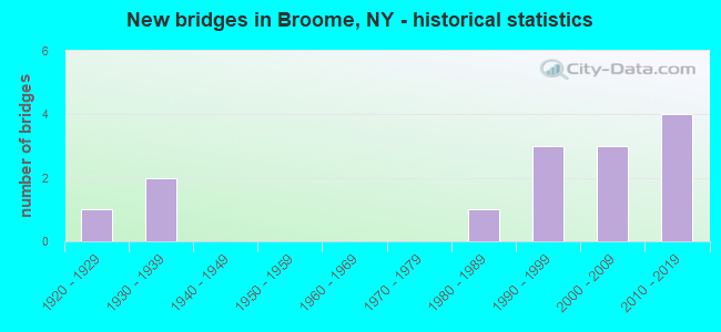
- New bridges - historical statistics
- 11920-1929
- 21930-1939
- 11980-1989
- 31990-1999
- 32000-2009
- 42010-2019

- Reconstructed bridges - Historical Statistics
- 21990-1999
- 12000-2009

- Bridge Condition - Deck
- 25.0%Excellent
- 25.0%Very good
- 8.3%Good
- 16.7%Satisfactory
- 25.0%Fair

- Bridge Condition - Superstructure
- 23.1%Excellent
- 30.8%Very good
- 15.4%Good
- 23.1%Satisfactory
- 7.7%Fair

- Bridge Condition - Substructure
- 15.4%Excellent
- 15.4%Very good
- 30.8%Good
- 7.7%Satisfactory
- 30.8%Fair

- Bridge Condition - Channel
- 14.3%Very good
- 21.4%Good
- 35.7%Satisfactory
- 28.6%Fair
Find on map >> Show street view
Structure Number: 103824, Location: 1.8 MI NW OF ALBANY CL (Lat: 42.487892, Lng: -74.270153), Route carried "on" structure: State highway 145, Year Built: 1931, Status: Open, Structure Length: 1.65m (5.41ft), Average Daily Traffic: 1,638 (year 2020), Truck Traffic: 13%, Average Future Daily Traffic: 1,648 (year 2040), Design Load: H 20, Features Intersected: LAKE CREEK
Minimum Vertical Clearance: 30+ m (98+ ft), Kilometerpoint: 2.961, Lanes on structure: 2, Base Highway Network: Yes, Owner: State Highway Agency, Approaching Roadway Width: 10.1m (33.1ft), Skew: 3 degrees, Material/Design: Steel continuous, Design/Construction: Stringer/Multi-beam, Number Of Spans In Main Unit: 2, Length of Maximum Span: 7.6m (24.9ft), Curb or Sidewalk Widths: Left: 1.5m (4.9ft), Right: 0.0m, Curb-To-Curb Width: 7.9m (25.9ft), Out-to-Out Width: 10.1m (33.1ft)
Condition: Deck: Fair, Superstructure: Fair, Substructure: Fair, Channel: Satisfactory, Operating Rating: 78.0 metric tons, Method Used To Determine Operating Rating: Load Factor (LF), Inventory Rating: 46.3 metric tons, Method Used To Determine Inventory Rating: Load Factor (LF), Structural Evaluation: Somewhat better than minimum adequacy, Deck Geometry: Meets minimum limits, Waterway Adequacy: Meets minimum limits, Approach Roadway Alignment: Equal to present desirable criteria, Length Of Structure Improvement: 1.64m (5.38ft), Designated Inspection Frequency: Every 24 months, Inspection Date: March 2021, Bridge Improvement Cost: $538,000, Roadway Improvement Cost: $315,000, Total Project Cost: $852,000 ( Estimate for 2021), Deck Structure Type: Concrete Cast-file-Place, Wearing Surface/Protective System: Wearing Surface: Bituminous
Find on map >> Show street view
Structure Number: 335477, Location: .3 MI W LIVINGSTONVILLE (Lat: 42.487778, Lng: -74.291914), Route carried "on" structure: County highway , Year Built: 2015, Status: Open, Structure Length: 1.22m (4.00ft), Average Daily Traffic: 154 (year 2017), Truck Traffic: 8%, Average Future Daily Traffic: 216 (year 2037), Design Load: HS 25 or greater, Features Intersected: TRIB CATSKILL CRK, Facility Carried by Structure: STONE STORE ROAD
Minimum Vertical Clearance: 30+ m (98+ ft), Kilometerpoint: 6.162, Lanes on structure: 2, Owner: County Highway Agency, Approaching Roadway Width: 6.1m (20.0ft), Material/Design: Steel, Design/Construction: Stringer/Multi-beam, Number Of Spans In Main Unit: 1, Length of Maximum Span: 11.6m (38.1ft), Curb-To-Curb Width: 6.2m (20.3ft), Out-to-Out Width: 6.5m (21.3ft)
Condition: Deck: Satisfactory, Superstructure: Very good, Substructure: Excellent, Channel: Very good, Operating Rating: 54.4 metric tons, Method Used To Determine Operating Rating: Allowable Stress (AS), Inventory Rating: 35.4 metric tons, Method Used To Determine Inventory Rating: Allowable Stress (AS), Structural Evaluation: Equal to present desirable criteria, Deck Geometry: Meets minimum limits, Waterway Adequacy: Equal to present desirable criteria, Approach Roadway Alignment: High priority of corrective action, Length Of Structure Improvement: 1.21m (3.97ft), Designated Inspection Frequency: Every 24 months, Inspection Date: August 2021, Bridge Improvement Cost: $307,000, Roadway Improvement Cost: $180,000, Total Project Cost: $487,000 ( Estimate for 2021), Deck Structure Type: Wood or Timber, Wearing Surface/Protective System: Wearing Surface: Bituminous
Find on map >> Show street view
Structure Number: 335478, Location: .6 MI N LIVINGSTONVILLE (Lat: 42.493903, Lng: -74.263292), Route carried "on" structure: County highway , Year Built: 2000, Status: Open, Structure Length: 1.68m (5.51ft), Average Daily Traffic: 204 (year 2017), Truck Traffic: 8%, Average Future Daily Traffic: 286 (year 2037), Design Load: HS 25 or greater, Features Intersected: LAKE CREEK, Facility Carried by Structure: HAUVERVILLE ROAD
Minimum Vertical Clearance: 30+ m (98+ ft), Kilometerpoint: 0.853, Lanes on structure: 2, Owner: County Highway Agency, Approaching Roadway Width: 7.3m (24.0ft), Skew: 1 degrees, Material/Design: Prestressed concrete, Design/Construction: Box Beam or Girders - Multiple, Number Of Spans In Main Unit: 1, Length of Maximum Span: 16.5m (54.1ft), Curb-To-Curb Width: 7.2m (23.6ft), Out-to-Out Width: 8.2m (26.9ft)
Condition: Deck: Fair, Superstructure: Satisfactory, Substructure: Good, Channel: Fair, Inventory Rating: 59.9 metric tons, Method Used To Determine Inventory Rating: Load Factor (LF), Structural Evaluation: Equal to present minimum criteria, Deck Geometry: Meets minimum limits, Waterway Adequacy: Equal to present desirable criteria, Approach Roadway Alignment: Meets minimum limits, Length Of Structure Improvement: 1.67m (5.48ft), Designated Inspection Frequency: Every 24 months, Inspection Date: April 2020, Bridge Improvement Cost: $465,000, Roadway Improvement Cost: $272,000, Total Project Cost: $738,000 ( Estimate for 2021), Wearing Surface/Protective System: Wearing Surface: Monolithic Concrete
Find on map >> Show street view
Structure Number: 335479, Location: 1 MI NE LIVINGSTONVILLE (Lat: 42.497836, Lng: -74.259836), Route carried "on" structure: County highway , Year Built: 2000, Status: Open, Structure Length: 2.56m (8.40ft), Average Daily Traffic: 204 (year 2017), Truck Traffic: 8%, Average Future Daily Traffic: 286 (year 2037), Design Load: HS 25 or greater, Features Intersected: LAKE CREEK, Facility Carried by Structure: HAUVERVILLE ROAD
Minimum Vertical Clearance: 30+ m (98+ ft), Kilometerpoint: 1.335, Lanes on structure: 2, Owner: County Highway Agency, Approaching Roadway Width: 7.3m (24.0ft), Skew: 3 degrees, Material/Design: Steel, Design/Construction: Stringer/Multi-beam, Number Of Spans In Main Unit: 1, Length of Maximum Span: 24.1m (79.1ft), Curb-To-Curb Width: 7.2m (23.6ft), Out-to-Out Width: 8.2m (26.9ft)
Condition: Deck: Very good, Superstructure: Very good, Substructure: Very good, Channel: Very good, Inventory Rating: 76.2 metric tons, Method Used To Determine Inventory Rating: Load Factor (LF), Structural Evaluation: Equal to present desirable criteria, Deck Geometry: Meets minimum limits, Waterway Adequacy: Equal to present desirable criteria, Approach Roadway Alignment: Meets minimum limits, Length Of Structure Improvement: 2.56m (8.40ft), Designated Inspection Frequency: Every 24 months, Inspection Date: April 2020, Bridge Improvement Cost: $783,000, Roadway Improvement Cost: $459,000, Total Project Cost: $1,242,000 ( Estimate for 2021), Deck Structure Type: Concrete Cast-file-Place, Wearing Surface/Protective System: Wearing Surface: Integral Concrete, Deck Protection: Epoxy Coated Reinforcing
Find on map >> Show street view
Structure Number: 33548, Location: 2 MI N OF LIVINGSTONVILLE (Lat: 42.508908, Lng: -74.253958), Route carried "on" structure: County highway , Year Built: 1999, Status: Open, Structure Length: 1.58m (5.18ft), Average Daily Traffic: 204 (year 2017), Truck Traffic: 8%, Average Future Daily Traffic: 286 (year 2037), Design Load: HS 25 or greater, Features Intersected: LAKE CREEK, Facility Carried by Structure: COUNTY RD 19A
Minimum Vertical Clearance: 30+ m (98+ ft), Kilometerpoint: 2.767, Lanes on structure: 2, Owner: County Highway Agency, Approaching Roadway Width: 7.3m (24.0ft), Skew: 4 degrees, Material/Design: Prestressed concrete, Design/Construction: Box Beam or Girders - Multiple, Number Of Spans In Main Unit: 1, Length of Maximum Span: 13.7m (44.9ft), Curb-To-Curb Width: 7.2m (23.6ft), Out-to-Out Width: 8.0m (26.2ft)
Condition: Deck: Very good, Superstructure: Very good, Substructure: Very good, Channel: Satisfactory, Inventory Rating: 57.2 metric tons, Method Used To Determine Inventory Rating: Load Factor (LF), Structural Evaluation: Equal to present desirable criteria, Deck Geometry: Meets minimum limits, Waterway Adequacy: Somewhat better than minimum adequacy, Approach Roadway Alignment: Equal to present minimum criteria, Length Of Structure Improvement: 1.58m (5.18ft), Designated Inspection Frequency: Every 24 months, Inspection Date: June 2021, Bridge Improvement Cost: $482,000, Roadway Improvement Cost: $282,000, Total Project Cost: $764,000 ( Estimate for 2021), Deck Structure Type: Concrete Cast-file-Place, Wearing Surface/Protective System: Wearing Surface: Monolithic Concrete, Deck Protection: Epoxy Coated Reinforcing
Find on map >> Show street view
Structure Number: 335481, Location: 2 MI N OF LIVINGSTONVILLE (Lat: 42.509664, Lng: -74.253392), Route carried "on" structure: County highway , Year Built: 2011, Status: Open, Structure Length: 0.76m (2.49ft), Average Daily Traffic: 204 (year 2017), Truck Traffic: 8%, Average Future Daily Traffic: 286 (year 2037), Features Intersected: WHITE CREEK, Facility Carried by Structure: COUNTY RD 19A
Minimum Vertical Clearance: 30+ m (98+ ft), Kilometerpoint: 2.880, Lanes on structure: 2, Owner: County Highway Agency, Approaching Roadway Width: 7.3m (24.0ft), Skew: 3 degrees, Material/Design: Concrete, Design/Construction: Culvert, Number Of Spans In Main Unit: 1, Length of Maximum Span: 7.0m (23.0ft)
Condition: Channel: Good, Culverts: Very good, Operating Rating: 35.4 metric tons, Method Used To Determine Operating Rating: Load Factor (LF), Inventory Rating: 27.2 metric tons, Method Used To Determine Inventory Rating: Load Factor (LF), Structural Evaluation: Equal to present minimum criteria, Waterway Adequacy: Somewhat better than minimum adequacy, Approach Roadway Alignment: Better than present minimum criteria, Length Of Structure Improvement: 0.76m (2.49ft), Designated Inspection Frequency: Every 24 months, Inspection Date: June 2021, Bridge Improvement Cost: $90,000, Roadway Improvement Cost: $53,000, Total Project Cost: $143,000 ( Estimate for 2021)
Find on map >> Show street view
Structure Number: 335482, Location: 2.6 MI NE OF LIVINGSTNVLE (Lat: 42.514053, Lng: -74.244647), Route carried "on" structure: County highway , Year Built: 1999, Status: Open, Structure Length: 2.19m (7.19ft), Average Daily Traffic: 204 (year 2017), Truck Traffic: 8%, Average Future Daily Traffic: 286 (year 2037), Design Load: HS 25 or greater, Features Intersected: LAKE CREEK, Facility Carried by Structure: HAUVERVILLE ROAD
Minimum Vertical Clearance: 30+ m (98+ ft), Kilometerpoint: 3.717, Lanes on structure: 2, Owner: County Highway Agency, Approaching Roadway Width: 7.3m (24.0ft), Skew: 4 degrees, Material/Design: Prestressed concrete, Design/Construction: Box Beam or Girders - Multiple, Number Of Spans In Main Unit: 1, Length of Maximum Span: 20.4m (66.9ft), Curb-To-Curb Width: 7.3m (24.0ft), Out-to-Out Width: 8.3m (27.2ft)
Condition: Deck: Fair, Superstructure: Satisfactory, Substructure: Fair, Channel: Satisfactory, Inventory Rating: 67.1 metric tons, Method Used To Determine Inventory Rating: Load Factor (LF), Structural Evaluation: Somewhat better than minimum adequacy, Deck Geometry: Somewhat better than minimum adequacy, Waterway Adequacy: Equal to present desirable criteria, Approach Roadway Alignment: Equal to present minimum criteria, Length Of Structure Improvement: 2.19m (7.19ft), Designated Inspection Frequency: Every 24 months, Inspection Date: April 2020, Bridge Improvement Cost: $556,000, Roadway Improvement Cost: $326,000, Total Project Cost: $882,000 ( Estimate for 2021), Deck Structure Type: Concrete Cast-file-Place, Wearing Surface/Protective System: Wearing Surface: Integral Concrete, Deck Protection: Epoxy Coated Reinforcing
Find on map >> Show street view
Structure Number: 335483, Location: 2.3 mi NE Livingstonville (Lat: 42.513828, Lng: -74.241394), Route carried "on" structure: County highway , Year Built: 1998, Year Reconstructed: 2012, Status: Open, Structure Length: 1.31m (4.30ft), Average Daily Traffic: 204 (year 2017), Truck Traffic: 8%, Average Future Daily Traffic: 286 (year 2037), Design Load: HL 93, Features Intersected: LAKE CREEK, Facility Carried by Structure: COUNTY ROAD 19A
Minimum Vertical Clearance: 30+ m (98+ ft), Kilometerpoint: 4.071, Lanes on structure: 2, Owner: County Highway Agency, Approaching Roadway Width: 7.3m (24.0ft), Skew: 4 degrees, Material/Design: Prestressed concrete, Design/Construction: Box Beam or Girders - Multiple, Number Of Spans In Main Unit: 1, Length of Maximum Span: 12.2m (40.0ft), Curb-To-Curb Width: 7.3m (24.0ft), Out-to-Out Width: 8.4m (27.6ft)
Condition: Deck: Excellent, Superstructure: Excellent, Substructure: Good, Channel: Good, Operating Rating: 59.6 metric tons, Method Used To Determine Operating Rating: Load and Resistance Factor Rating (LRFR) rating reported by rating factor(RF) method using HL-93 loadings, Inventory Rating: 46.0 metric tons, Method Used To Determine Inventory Rating: Load and Resistance Factor Rating (LRFR) rating reported by rating factor(RF) method using HL-93 loadings, Structural Evaluation: Better than present minimum criteria, Deck Geometry: Somewhat better than minimum adequacy, Waterway Adequacy: Somewhat better than minimum adequacy, Approach Roadway Alignment: Equal to present desirable criteria, Length Of Structure Improvement: 1.31m (4.30ft), Designated Inspection Frequency: Every 24 months, Inspection Date: November 2020, Bridge Improvement Cost: $410,000, Roadway Improvement Cost: $240,000, Total Project Cost: $650,000 ( Estimate for 2021), Wearing Surface/Protective System: Wearing Surface: Bituminous, Membrane: Other
Find on map >> Show street view
Structure Number: 335484, Location: CR19A - .3 MI W CO LINE (Lat: 42.510892, Lng: -74.232350), Route carried "on" structure: County highway , Year Built: 1986, Status: Open, Structure Length: 1.34m (4.40ft), Average Daily Traffic: 204 (year 2017), Truck Traffic: 8%, Average Future Daily Traffic: 286 (year 2037), Features Intersected: LAKE CREEK, Facility Carried by Structure: COUNTY RD 19A
Minimum Vertical Clearance: 30+ m (98+ ft), Kilometerpoint: 4.891, Lanes on structure: 2, Owner: County Highway Agency, Approaching Roadway Width: 6.7m (22.0ft), Skew: 5 degrees, Material/Design: Prestressed concrete, Design/Construction: Stringer/Multi-beam, Number Of Spans In Main Unit: 1, Length of Maximum Span: 12.4m (40.7ft), Curb-To-Curb Width: 7.3m (24.0ft), Out-to-Out Width: 8.6m (28.2ft)
Condition: Deck: Good, Superstructure: Good, Substructure: Fair, Channel: Fair, Operating Rating: 56.2 metric tons, Method Used To Determine Operating Rating: Load Factor (LF), Inventory Rating: 33.6 metric tons, Method Used To Determine Inventory Rating: Load Factor (LF), Structural Evaluation: Somewhat better than minimum adequacy, Deck Geometry: Somewhat better than minimum adequacy, Waterway Adequacy: Meets minimum limits, Approach Roadway Alignment: Equal to present desirable criteria, Length Of Structure Improvement: 1.34m (4.40ft), Designated Inspection Frequency: Every 24 months, Inspection Date: June 2021, Bridge Improvement Cost: $560,000, Roadway Improvement Cost: $328,000, Total Project Cost: $887,000 ( Estimate for 2021), Wearing Surface/Protective System: Wearing Surface: Bituminous
Find on map >> Show street view
Structure Number: 335485, Location: 1.9 MI NE LIVINGSTONVILLE (Lat: 42.510914, Lng: -74.228050), Route carried "on" structure: County highway , Year Built: 1930, Year Reconstructed: 1990, Status: Open, Structure Length: 0.94m (3.08ft), Average Daily Traffic: 204 (year 2017), Truck Traffic: 8%, Average Future Daily Traffic: 286 (year 2037), Design Load: HS 20, Features Intersected: LAKE CREEK, Facility Carried by Structure: HAUVERVILLE ROAD
Minimum Vertical Clearance: 30+ m (98+ ft), Kilometerpoint: 5.310, Lanes on structure: 2, Owner: County Highway Agency, Approaching Roadway Width: 5.5m (18.0ft), Skew: 3 degrees, Material/Design: Wood or Timber, Design/Construction: Slab, Number Of Spans In Main Unit: 1, Length of Maximum Span: 9.1m (29.9ft), Curb-To-Curb Width: 6.5m (21.3ft), Out-to-Out Width: 7.3m (24.0ft)
Condition: Deck: Very good, Superstructure: Good, Substructure: Satisfactory, Channel: Fair, Operating Rating: 94.3 metric tons, Method Used To Determine Operating Rating: Load Factor (LF), Inventory Rating: 65.3 metric tons, Method Used To Determine Inventory Rating: Load Factor (LF), Structural Evaluation: Equal to present minimum criteria, Deck Geometry: Meets minimum limits, Waterway Adequacy: Somewhat better than minimum adequacy, Approach Roadway Alignment: Somewhat better than minimum adequacy, Length Of Structure Improvement: 0.94m (3.08ft), Designated Inspection Frequency: Every 24 months, Inspection Date: November 2021, Bridge Improvement Cost: $293,000, Roadway Improvement Cost: $171,000, Total Project Cost: $464,000 ( Estimate for 2021), Wearing Surface/Protective System: Wearing Surface: Bituminous
Find on map >> Show street view
Structure Number: 335486, Location: .5 MI S LIVINGSTONVILLE (Lat: 42.485128, Lng: -74.267597), Route carried "on" structure: Other road , Year Built: 1929, Year Reconstructed: 1999, Status: Open, Structure Length: 1.31m (4.30ft), Average Daily Traffic: 1 (year 2017), Truck Traffic: 5%, Average Future Daily Traffic: 1 (year 2037), Features Intersected: CATSKILL CREEK, Facility Carried by Structure: MATTICE ROAD
Minimum Vertical Clearance: 30+ m (98+ ft), Kilometerpoint: 0.193, Lanes on structure: 2, Owner: County Highway Agency, Approaching Roadway Width: 5.2m (17.1ft), Material/Design: Steel, Design/Construction: Stringer/Multi-beam, Number Of Spans In Main Unit: 1, Length of Maximum Span: 12.8m (42.0ft), Curb-To-Curb Width: 5.2m (17.1ft), Out-to-Out Width: 5.5m (18.0ft)
Condition: Deck: Satisfactory, Superstructure: Satisfactory, Substructure: Fair, Channel: Satisfactory, Operating Rating: 42.6 metric tons, Method Used To Determine Operating Rating: Load Factor (LF), Inventory Rating: 25.4 metric tons, Method Used To Determine Inventory Rating: Load Factor (LF), Structural Evaluation: Somewhat better than minimum adequacy, Deck Geometry: High priority of corrective action, Waterway Adequacy: Meets minimum limits, Approach Roadway Alignment: Equal to present desirable criteria, Length Of Structure Improvement: 1.31m (4.30ft), Designated Inspection Frequency: Every 24 months, Inspection Date: May 2021, Bridge Improvement Cost: $264,000, Roadway Improvement Cost: $155,000, Total Project Cost: $419,000 ( Estimate for 2021), Deck Structure Type: Wood or Timber, Wearing Surface/Protective System: Wearing Surface: Wood or Timber
Find on map >> Show street view
Structure Number: 335487, Location: 0.9 MI SE LIVINGSTONEVILL (Lat: 42.472378, Lng: -74.247792), Route carried "on" structure: Other road , Year Built: 2014, Status: Open, Structure Length: 3.14m (10.30ft), Average Daily Traffic: 2 (year 2019), Truck Traffic: 5%, Average Future Daily Traffic: 3 (year 2039), Design Load: HS 20, Features Intersected: CATSKILL CREEK, Facility Carried by Structure: CC CAMP ROAD
Minimum Vertical Clearance: 32.69m (107.25ft), Kilometerpoint: 1.078, Lanes on structure: 1, Owner: County Highway Agency, Approaching Roadway Width: 5.5m (18.0ft), Material/Design: Steel, Design/Construction: Truss - Thru, Number Of Spans In Main Unit: 1, Length of Maximum Span: 30.5m (100.1ft), Curb-To-Curb Width: 5.5m (18.0ft), Out-to-Out Width: 6.8m (22.3ft)
Condition: Deck: Excellent, Superstructure: Excellent, Substructure: Excellent, Channel: Satisfactory, Operating Rating: 65.3 metric tons, Method Used To Determine Operating Rating: Load Factor (LF), Inventory Rating: 50.8 metric tons, Method Used To Determine Inventory Rating: Load Factor (LF), Structural Evaluation: Superior to present desirable criteria, Deck Geometry: Meets minimum limits, Waterway Adequacy: Equal to present minimum criteria, Approach Roadway Alignment: Meets minimum limits, Length Of Structure Improvement: 3.13m (10.27ft), Designated Inspection Frequency: Every 24 months, Critical Feature Inspection Frequency: Every 24 months, Inspection Date: March 2021, Critical Feature Inspection Date: March 2021, Bridge Improvement Cost: $1,619,000, Roadway Improvement Cost: $948,000, Total Project Cost: $2,566,000 ( Estimate for 2021), Deck Structure Type: Concrete Cast-file-Place, Wearing Surface/Protective System: Wearing Surface: Integral Concrete, Deck Protection: Epoxy Coated Reinforcing
Find on map >> Show street view
Structure Number: 335488, Location: 5 MI SE OF BROOME CENTER (Lat: 42.446181, Lng: -74.274678), Route carried "on" structure: Other road , Year Built: 2019, Status: Open, Structure Length: 1.16m (3.81ft), Truck Traffic: 10%, Design Load: HS 20, Features Intersected: TRIB CATSKILL CRK, Facility Carried by Structure: BATES CHURCH ROAD
Minimum Vertical Clearance: 30+ m (98+ ft), Kilometerpoint: 0.032, Lanes on structure: 2, Owner: County Highway Agency, Approaching Roadway Width: 4.6m (15.1ft), Skew: 1 degrees, Material/Design: Steel, Design/Construction: Stringer/Multi-beam, Number Of Spans In Main Unit: 1, Length of Maximum Span: 11.0m (36.1ft), Curb-To-Curb Width: 9.6m (31.5ft), Out-to-Out Width: 9.7m (31.8ft)
Condition: Deck: Excellent, Superstructure: Excellent, Substructure: Good, Channel: Fair, Operating Rating: 67.1 metric tons, Method Used To Determine Operating Rating: Allowable Stress (AS), Inventory Rating: 49.9 metric tons, Method Used To Determine Inventory Rating: Allowable Stress (AS), Structural Evaluation: Better than present minimum criteria, Deck Geometry: Better than present minimum criteria, Waterway Adequacy: Meets minimum limits, Approach Roadway Alignment: Meets minimum limits, Length Of Structure Improvement: 1.15m (3.77ft), Designated Inspection Frequency: Every 24 months, Inspection Date: November 2021, Bridge Improvement Cost: $419,000, Roadway Improvement Cost: $245,000, Total Project Cost: $664,000 ( Estimate for 2021), Deck Structure Type: Wood or Timber, Wearing Surface/Protective System: Wearing Surface: Bituminous
Find on map >> Show street view
Structure Number: 336967, Location: NEAR JCT OF CR19 & SH 145 (Lat: 42.487742, Lng: -74.286397), Route carried "on" structure: Alternate County highway , Year Built: 2005, Status: Open, Structure Length: 1.68m (5.51ft), Average Daily Traffic: 154 (year 2017), Truck Traffic: 8%, Average Future Daily Traffic: 216 (year 2037), Design Load: HS 25 or greater, Features Intersected: CATSKILL CREEK, Facility Carried by Structure: STONE STORE ROAD
Minimum Vertical Clearance: 30+ m (98+ ft), Kilometerpoint: 6.533, Lanes on structure: 2, Owner: County Highway Agency, Approaching Roadway Width: 8.5m (27.9ft), Skew: 5 degrees, Material/Design: Concrete, Design/Construction: Frame, Number Of Spans In Main Unit: 1, Length of Maximum Span: 16.5m (54.1ft), Curb-To-Curb Width: 8.5m (27.9ft), Out-to-Out Width: 9.1m (29.9ft)
Condition: Superstructure: Very good, Substructure: Good, Channel: Good, Inventory Rating: 59.9 metric tons, Method Used To Determine Inventory Rating: Load Factor (LF), Structural Evaluation: Better than present minimum criteria, Deck Geometry: Equal to present minimum criteria, Waterway Adequacy: Equal to present minimum criteria, Approach Roadway Alignment: Equal to present desirable criteria, Length Of Structure Improvement: 1.67m (5.48ft), Designated Inspection Frequency: Every 24 months, Inspection Date: November 2021, Bridge Improvement Cost: $306,000, Roadway Improvement Cost: $179,000, Total Project Cost: $484,000 ( Estimate for 2021)