Bridge Statistics for Bell, California (CA)
Condition, Traffic, Stress, Structural Evaluation, Project Costs
- National Bridge Inventory (NBI) Statistics
- 25Number of bridges
- 295ft / 89.6mTotal length
- $10,308,000Total costs
- 2,639,912Total average daily traffic
- 259,224Total average daily truck traffic
- National Bridge Inventory (NBI) Registered Bridges for Bell
- No street view available for this location
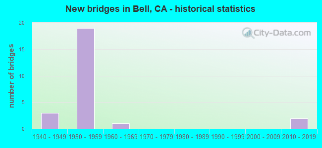
- New bridges - historical statistics
- 31940-1949
- 191950-1959
- 11960-1969
- 22010-2019


- Bridge Condition - Deck
- 69.2%Good
- 15.4%Fair
- 15.4%Poor

- Bridge Condition - Superstructure
- 84.6%Good
- 15.4%Fair

- Bridge Condition - Channel
- 75.0%Excellent
- 25.0%Very good
Find on map >> Show street view
Structure Number: 53 083, Location: 07-LA-710-17.68-SGT (Lat: 33.938811, Lng: -118.171792), Route carried "on" structure: Interstate 710, Year Built: 1957, Status: Open, Structure Length: 1.07m (3.51ft), Average Daily Traffic: 223,000 (year 2017), Truck Traffic: 14%, Average Future Daily Traffic: 234,092 (year 2037), Design Load: HS 20, Features Intersected: MILLER WAY
Minimum Vertical Clearance: 30+ m (98+ ft), Kilometerpoint: 17.680, Lanes on structure: 8, Lanes under structure: 1, Base Highway Network: Yes (Inventory Route: 7, Subroute: 1), Owner: State Highway Agency, Approaching Roadway Width: 39.0m (128.0ft), Material/Design: Concrete, Design/Construction: Slab, Number Of Spans In Main Unit: 1, Length of Maximum Span: 9.4m (30.8ft), Curb-To-Curb Width: 39.0m (128.0ft), Out-to-Out Width: 53.5m (175.5ft)
Condition: Deck: Good, Superstructure: Good, Substructure: Good, Operating Rating: 66.7 metric tons, Method Used To Determine Operating Rating: Load Factor (LF), Inventory Rating: 40.2 metric tons, Method Used To Determine Inventory Rating: Load Factor (LF), Structural Evaluation: Better than present minimum criteria, Deck Geometry: Superior to present desirable criteria, Underclear: High priority of corrective action, Approach Roadway Alignment: Meets minimum limits, Designated Inspection Frequency: Every 24 months, Inspection Date: May 2020, Deck Structure Type: Concrete Cast-file-Place, Wearing Surface/Protective System: Wearing Surface: Integral Concrete
Find on map >> Show street view
Structure Number: 53 0833, Location: 07-LA-710-19.40-BELL (Lat: 33.963583, Lng: -118.169731), Route carried "on" structure: City street L677, Year Built: 1957, Status: Open, Structure Length: 4.21m (13.81ft), Average Daily Traffic: 10,800 (year 2012), Truck Traffic: 2%, Average Future Daily Traffic: 15,900 (year 2037), Design Load: HS 20, Features Intersected: INTERSTATE 710, Facility Carried by Structure: CLARA STREET
Minimum Vertical Clearance: 30+ m (98+ ft), Kilometerpoint: 0.000, Lanes on structure: 2, Lanes under structure: 8, Owner: State Highway Agency, Approaching Roadway Width: 16.5m (54.1ft), Material/Design: Concrete continuous, Design/Construction: Tee Beam, Number Of Spans In Main Unit: 2, Length of Maximum Span: 20.1m (65.9ft), Curb or Sidewalk Widths: Left: 1.5m (4.9ft), Right: 1.5m (4.9ft), Curb-To-Curb Width: 16.5m (54.1ft), Out-to-Out Width: 17.1m (56.1ft)
Condition: Deck: Good, Superstructure: Good, Substructure: Good, Operating Rating: 39.5 metric tons, Method Used To Determine Operating Rating: Load and Resistance Factor Rating (LRFR) rating reported by rating factor(RF) method using HL-93 loadings, Inventory Rating: 28.2 metric tons, Method Used To Determine Inventory Rating: Load and Resistance Factor Rating (LRFR) rating reported by rating factor(RF) method using HL-93 loadings, Structural Evaluation: Better than present minimum criteria, Deck Geometry: Superior to present desirable criteria, Underclear: Meets minimum limits, Approach Roadway Alignment: Equal to present desirable criteria, Designated Inspection Frequency: Every 24 months, Inspection Date: May 2020, Deck Structure Type: Concrete Cast-file-Place
Find on map >> Show street view
Structure Number: 53 0834, Location: 07-LA-710-19.73-BELL (Lat: 33.968097, Lng: -118.168186), Route carried "on" structure: City street L120, Year Built: 1957, Status: Open, Structure Length: 6.80m (22.31ft), Average Daily Traffic: 34,600 (year 2011), Truck Traffic: 2%, Average Future Daily Traffic: 51,200 (year 2037), Design Load: HS 20, Features Intersected: INTERSTATE 710, Facility Carried by Structure: FLORENCE AVE
Minimum Vertical Clearance: 30+ m (98+ ft), Kilometerpoint: 0.000, Lanes on structure: 4, Lanes under structure: 16, Base Highway Network: Yes, Owner: State Highway Agency, Approaching Roadway Width: 23.8m (78.1ft), Material/Design: Concrete continuous, Design/Construction: Tee Beam, Number Of Spans In Main Unit: 4, Length of Maximum Span: 20.1m (65.9ft), Curb or Sidewalk Widths: Left: 1.5m (4.9ft), Right: 1.5m (4.9ft), Curb-To-Curb Width: 22.6m (74.1ft), Out-to-Out Width: 26.2m (86.0ft)
Condition: Deck: Good, Superstructure: Good, Substructure: Good, Operating Rating: 29.2 metric tons, Method Used To Determine Operating Rating: Load and Resistance Factor Rating (LRFR) rating reported by rating factor(RF) method using HL-93 loadings, Inventory Rating: 22.4 metric tons, Method Used To Determine Inventory Rating: Load and Resistance Factor Rating (LRFR) rating reported by rating factor(RF) method using HL-93 loadings, Structural Evaluation: Somewhat better than minimum adequacy, Deck Geometry: Superior to present desirable criteria, Underclear: High priority of corrective action, Approach Roadway Alignment: Superior to present desirable criteria, Designated Inspection Frequency: Every 24 months, Inspection Date: May 2020, Deck Structure Type: Concrete Cast-file-Place
Find on map >> Show street view
Structure Number: 53 0835, Location: 07-LA-710-20.27-BELL (Lat: 33.975881, Lng: -118.167839), Route carried "on" structure: City street L123, Year Built: 1957, Status: Open, Structure Length: 4.08m (13.39ft), Average Daily Traffic: 17,700 (year 2009), Truck Traffic: 2%, Average Future Daily Traffic: 27,333 (year 2042), Design Load: HS 20, Features Intersected: INTERSTATE 710, Facility Carried by Structure: GAGE AVENUE
Minimum Vertical Clearance: 30+ m (98+ ft), Kilometerpoint: 0.000, Lanes on structure: 4, Lanes under structure: 8, Owner: State Highway Agency, Approaching Roadway Width: 13.4m (44.0ft), Material/Design: Concrete continuous, Design/Construction: Tee Beam, Number Of Spans In Main Unit: 2, Length of Maximum Span: 19.5m (64.0ft), Curb or Sidewalk Widths: Left: 1.5m (4.9ft), Right: 1.5m (4.9ft), Curb-To-Curb Width: 16.5m (54.1ft), Out-to-Out Width: 17.1m (56.1ft)
Condition: Deck: Good, Superstructure: Good, Substructure: Good, Operating Rating: 36.3 metric tons, Method Used To Determine Operating Rating: Load and Resistance Factor Rating (LRFR) rating reported by rating factor(RF) method using HL-93 loadings, Inventory Rating: 25.9 metric tons, Method Used To Determine Inventory Rating: Load and Resistance Factor Rating (LRFR) rating reported by rating factor(RF) method using HL-93 loadings, Structural Evaluation: Equal to present minimum criteria, Deck Geometry: Meets minimum limits, Underclear: High priority of corrective action, Approach Roadway Alignment: Superior to present desirable criteria, Designated Inspection Frequency: Every 24 months, Inspection Date: July 2020, Deck Structure Type: Concrete Cast-file-Place
Find on map >> Show street view
Structure Number: 53 0837, Location: 07-LA-710-21.03-BELL (Lat: 33.986550, Lng: -118.169994), Route carried "on" structure: City street L125, Year Built: 1957, Status: Open, Structure Length: 4.75m (15.58ft), Average Daily Traffic: 31,500 (year 2009), Truck Traffic: 2%, Average Future Daily Traffic: 46,858 (year 2042), Design Load: HS 20, Features Intersected: INTERSTATE 710, Facility Carried by Structure: SLAUSON AVE
Minimum Vertical Clearance: 30+ m (98+ ft), Kilometerpoint: 0.000, Lanes on structure: 4, Lanes under structure: 8, Owner: State Highway Agency, Approaching Roadway Width: 21.3m (69.9ft), Skew: 3 degrees, Material/Design: Concrete continuous, Design/Construction: Box Beam or Girders - Multiple, Number Of Spans In Main Unit: 2, Length of Maximum Span: 23.5m (77.1ft), Curb or Sidewalk Widths: Left: 1.8m (5.9ft), Right: 1.8m (5.9ft), Curb-To-Curb Width: 21.3m (69.9ft), Out-to-Out Width: 25.6m (84.0ft)
Condition: Deck: Good, Superstructure: Fair, Substructure: Good, Operating Rating: 43.1 metric tons, Method Used To Determine Operating Rating: Load and Resistance Factor Rating (LRFR) rating reported by rating factor(RF) method using HL-93 loadings, Inventory Rating: 30.8 metric tons, Method Used To Determine Inventory Rating: Load and Resistance Factor Rating (LRFR) rating reported by rating factor(RF) method using HL-93 loadings, Structural Evaluation: Somewhat better than minimum adequacy, Deck Geometry: Superior to present desirable criteria, Underclear: High priority of corrective action, Approach Roadway Alignment: Somewhat better than minimum adequacy, Designated Inspection Frequency: Every 24 months, Inspection Date: July 2020, Deck Structure Type: Concrete Cast-file-Place, Wearing Surface/Protective System: Wearing Surface: Integral Concrete
Find on map >> Show street view
Structure Number: 53 0839, Location: 07-LA-710-21.80-BELL (Lat: 33.995772, Lng: -118.176669), Route carried "on" structure: Interstate 710, Year Built: 1957, Status: Open, Structure Length: 1.16m (3.81ft), Average Daily Traffic: 207,000 (year 2017), Truck Traffic: 9%, Average Future Daily Traffic: 215,835 (year 2037), Design Load: HS 20, Features Intersected: LA JUNCTION RY
Minimum Vertical Clearance: 30+ m (98+ ft), Kilometerpoint: 21.800, Lanes on structure: 9, Base Highway Network: Yes (Inventory Route: 7, Subroute: 1), Owner: State Highway Agency, Approaching Roadway Width: 48.8m (160.1ft), Skew: 30 degrees, Material/Design: Concrete, Design/Construction: Slab, Number Of Spans In Main Unit: 1, Length of Maximum Span: 10.7m (35.1ft), Curb-To-Curb Width: 57.0m (187.0ft), Out-to-Out Width: 58.2m (190.9ft)
Condition: Deck: Good, Superstructure: Good, Substructure: Good, Operating Rating: 75.8 metric tons, Method Used To Determine Operating Rating: Load Factor (LF), Inventory Rating: 45.7 metric tons, Method Used To Determine Inventory Rating: Load Factor (LF), Structural Evaluation: Better than present minimum criteria, Deck Geometry: Superior to present desirable criteria, Underclear: Meets minimum limits, Approach Roadway Alignment: Meets minimum limits, Designated Inspection Frequency: Every 24 months, Inspection Date: July 2020
Find on map >> Show street view
Structure Number: 53 0839K, Location: 07-LA-710-21.79-BELL (Lat: 33.995622, Lng: -118.177533), Route carried "on" structure: Ramp Interstate 710, Year Built: 1957, Status: Open, Structure Length: 3.38m (11.09ft), Average Daily Traffic: 1,000 (year 2009), Truck Traffic: 8%, Average Future Daily Traffic: 1,535 (year 2042), Design Load: HS 20, Features Intersected: LA JUNCTION RY
Minimum Vertical Clearance: 30+ m (98+ ft), Kilometerpoint: 21.790, Lanes on structure: 2, Base Highway Network: Yes, Owner: State Highway Agency, Approaching Roadway Width: 8.5m (27.9ft), Material/Design: Concrete continuous, Design/Construction: Tee Beam, Number Of Spans In Main Unit: 3, Length of Maximum Span: 13.1m (43.0ft), Curb-To-Curb Width: 8.5m (27.9ft), Out-to-Out Width: 9.6m (31.5ft)
Condition: Deck: Good, Superstructure: Good, Substructure: Good, Operating Rating: 41.1 metric tons, Method Used To Determine Operating Rating: Load and Resistance Factor Rating (LRFR) rating reported by rating factor(RF) method using HL-93 loadings, Inventory Rating: 31.8 metric tons, Method Used To Determine Inventory Rating: Load and Resistance Factor Rating (LRFR) rating reported by rating factor(RF) method using HL-93 loadings, Structural Evaluation: Better than present minimum criteria, Deck Geometry: High priority of corrective action, Underclear: Somewhat better than minimum adequacy, Approach Roadway Alignment: Superior to present desirable criteria, Designated Inspection Frequency: Every 24 months, Inspection Date: July 2020, Deck Structure Type: Concrete Cast-file-Place
Find on map >> Show street view
Structure Number: 53 1004S, Location: 07-LA-014-R54.50 (Lat: 34.509881, Lng: -118.110897), Route carried "on" structure: Bypass State highway 14, Year Built: 1965, Status: Open, Structure Length: 10.27m (33.69ft), Average Daily Traffic: 4,200 (year 2017), Truck Traffic: 2%, Average Future Daily Traffic: 6,306 (year 2041), Design Load: HS 20, Features Intersected: SIERRA HWY
Minimum Vertical Clearance: 30+ m (98+ ft), Kilometerpoint: 54.500, Lanes on structure: 2, Lanes under structure: 2, Base Highway Network: Yes (, Subroute: 1), Owner: State Highway Agency, Approaching Roadway Width: 8.5m (27.9ft), Material/Design: Concrete continuous, Design/Construction: Box Beam or Girders - Multiple, Number Of Spans In Main Unit: 4, Length of Maximum Span: 26.8m (87.9ft), Curb or Sidewalk Widths: Left: 0.6m (2.0ft), Right: 0.6m (2.0ft), Curb-To-Curb Width: 8.5m (27.9ft), Out-to-Out Width: 10.4m (34.1ft)
Condition: Deck: Fair, Superstructure: Good, Substructure: Good, Operating Rating: 34.7 metric tons, Method Used To Determine Operating Rating: Load and Resistance Factor Rating (LRFR) rating reported by rating factor(RF) method using HL-93 loadings, Inventory Rating: 26.9 metric tons, Method Used To Determine Inventory Rating: Load and Resistance Factor Rating (LRFR) rating reported by rating factor(RF) method using HL-93 loadings, Structural Evaluation: Equal to present minimum criteria, Deck Geometry: High priority of corrective action, Underclear: Meets minimum limits, Approach Roadway Alignment: Equal to present desirable criteria, Designated Inspection Frequency: Every 24 months, Inspection Date: March 2021, Deck Structure Type: Concrete Cast-file-Place
Find on map >> Show street view
Structure Number: 53 1009, Location: 07-LA-710-21.92-BELL (Lat: 33.997600, Lng: -118.176508), Route carried "on" structure: Interstate 710, Year Built: 1957, Year Reconstructed: 1967, Status: Open, Structure Length: 4.75m (15.58ft), Average Daily Traffic: 217,000 (year 2017), Truck Traffic: 9%, Average Future Daily Traffic: 230,000 (year 2037), Design Load: HS 20, Features Intersected: ATLANTIC BLVD
Minimum Vertical Clearance: 30+ m (98+ ft), Kilometerpoint: 21.920, Lanes on structure: 9, Lanes under structure: 5, Base Highway Network: Yes (Inventory Route: 7, Subroute: 1), Owner: State Highway Agency, Approaching Roadway Width: 39.3m (128.9ft), Skew: 34 degrees, Material/Design: Concrete continuous, Design/Construction: Box Beam or Girders - Multiple, Number Of Spans In Main Unit: 2, Length of Maximum Span: 24.1m (79.1ft), Curb-To-Curb Width: 34.9m (114.5ft), Out-to-Out Width: 36.6m (120.1ft)
Condition: Deck: Good, Superstructure: Good, Substructure: Good, Operating Rating: 95.3 metric tons, Method Used To Determine Operating Rating: Load Factor (LF), Inventory Rating: 57.3 metric tons, Method Used To Determine Inventory Rating: Load Factor (LF), Structural Evaluation: Better than present minimum criteria, Deck Geometry: Meets minimum limits, Underclear: Meets minimum limits, Approach Roadway Alignment: Equal to present minimum criteria, Designated Inspection Frequency: Every 24 months, Inspection Date: July 2020, Deck Structure Type: Concrete Cast-file-Place
Find on map >> Show street view
Structure Number: 53 1036M, Location: 07-LA-710-21.50-BELL (Lat: 33.993217, Lng: -118.175736), Route carried "on" structure: Interstate 710, Year Built: 1957, Status: Open, Structure Length: 0.79m (2.59ft), Average Daily Traffic: 207,000 (year 2017), Truck Traffic: 9%, Average Future Daily Traffic: 225,835 (year 2037), Features Intersected: STORM DRAIN
Minimum Vertical Clearance: 30+ m (98+ ft), Kilometerpoint: 21.500, Lanes on structure: 6, Base Highway Network: Yes (Inventory Route: 7, Subroute: 1), Owner: State Highway Agency, Approaching Roadway Width: 41.6m (136.5ft), Skew: 36 degrees, Material/Design: Concrete, Design/Construction: Culvert, Number Of Spans In Main Unit: 2, Length of Maximum Span: 4.0m (13.1ft)
Condition: Channel: Very good, Culverts: Good, Structural Evaluation: Better than present minimum criteria, Waterway Adequacy: Equal to present desirable criteria, Approach Roadway Alignment: Meets minimum limits, Designated Inspection Frequency: Every 24 months, Inspection Date: July 2020
Find on map >> Show street view
Structure Number: 53 3067K, Location: 07-LA-710-21.91-BELL (Lat: 33.997397, Lng: -118.177078), Route carried "on" structure: Interstate 710, Year Built: 2013, Status: Open, Structure Length: 4.24m (13.91ft), Average Daily Traffic: 5,990 (year 2015), Truck Traffic: 9%, Average Future Daily Traffic: 7,800 (year 2037), Design Load: HL 93, Features Intersected: S ATLANTIC BLVD
Minimum Vertical Clearance: 30+ m (98+ ft), Kilometerpoint: 21.910, Lanes on structure: 2, Lanes under structure: 6, Base Highway Network: Yes, Owner: State Highway Agency, Approaching Roadway Width: 10.6m (34.8ft), Skew: 3 degrees, Material/Design: Prestressed concrete, Design/Construction: Box Beam or Girders - Multiple, Number Of Spans In Main Unit: 1, Length of Maximum Span: 41.4m (135.8ft), Curb-To-Curb Width: 10.6m (34.8ft), Out-to-Out Width: 11.0m (36.1ft)
Condition: Deck: Good, Superstructure: Good, Substructure: Good, Operating Rating: 42.1 metric tons, Method Used To Determine Operating Rating: Assigned ratings based on Load and Resistance Factor Design (LRFD) reported by rating factor (RF) using HL93 loadings, Inventory Rating: 32.4 metric tons, Method Used To Determine Inventory Rating: Assigned ratings based on Load and Resistance Factor Design (LRFD) reported by rating factor (RF) using HL93 loadings, Structural Evaluation: Better than present minimum criteria, Deck Geometry: Meets minimum limits, Underclear: High priority of corrective action, Approach Roadway Alignment: Equal to present desirable criteria, Designated Inspection Frequency: Every 24 months, Inspection Date: July 2020, Deck Structure Type: Concrete Cast-file-Place
Find on map >> Show street view
Structure Number: 53C0071, Location: 0.3MI W/O WESTERN AVE (Lat: 33.968492, Lng: -118.171100), Route carried "on" structure: City street L120, Year Built: 1948, Status: Open, Structure Length: 14.05m (46.10ft), Average Daily Traffic: 42,930 (year 2012), Truck Traffic: 5%, Average Future Daily Traffic: 51,516 (year 2041), Design Load: HS 20, Features Intersected: LOS ANGELES RIV, Facility Carried by Structure: FLORENCE AVE
Minimum Vertical Clearance: 30.47m (99.97ft), Kilometerpoint: 0.000, Lanes on structure: 4, Owner: City or Municipal Highway Agency, Approaching Roadway Width: 14.6m (47.9ft), Material/Design: Concrete continuous, Design/Construction: Tee Beam, Number Of Spans In Main Unit: 6, Length of Maximum Span: 25.3m (83.0ft), Curb or Sidewalk Widths: Left: 1.3m (4.3ft), Right: 1.3m (4.3ft), Curb-To-Curb Width: 14.7m (48.2ft), Out-to-Out Width: 18.2m (59.7ft)
Condition: Deck: Fair, Superstructure: Good, Substructure: Good, Channel: Excellent, Operating Rating: 52.2 metric tons, Method Used To Determine Operating Rating: Load Factor (LF), Inventory Rating: 31.8 metric tons, Method Used To Determine Inventory Rating: Load Factor (LF), Structural Evaluation: Better than present minimum criteria, Deck Geometry: High priority of replacement, Waterway Adequacy: Superior to present desirable criteria, Approach Roadway Alignment: Equal to present minimum criteria, Designated Inspection Frequency: Every 24 months, Inspection Date: December 2021, Deck Structure Type: Concrete Cast-file-Place, Wearing Surface/Protective System: Wearing Surface: Monolithic Concrete
Find on map >> Show street view
Structure Number: 53C0159, Location: 0.1MI W/O I-710 FWY (Lat: 33.976172, Lng: -118.170044), Route carried "on" structure: City street L123, Year Built: 1940, Status: Open, Structure Length: 14.51m (47.60ft), Average Daily Traffic: 27,454 (year 2012), Truck Traffic: 5%, Average Future Daily Traffic: 32,945 (year 2041), Features Intersected: LOS ANGELES RIV, Facility Carried by Structure: GAGE AVE
Minimum Vertical Clearance: 6.10m (20.01ft), Kilometerpoint: 0.000, Lanes on structure: 4, Owner: City or Municipal Highway Agency, Approaching Roadway Width: 13.4m (44.0ft), Material/Design: Concrete continuous, Design/Construction: Tee Beam, Number Of Spans In Main Unit: 5, Length of Maximum Span: 30.5m (100.1ft), Curb or Sidewalk Widths: Left: 1.6m (5.2ft), Right: 1.6m (5.2ft), Curb-To-Curb Width: 13.3m (43.6ft), Out-to-Out Width: 17.0m (55.8ft)
Condition: Deck: Poor, Superstructure: Good, Substructure: Good, Channel: Excellent, Operating Rating: 42.1 metric tons, Method Used To Determine Operating Rating: Load Factor (LF), Inventory Rating: 25.3 metric tons, Method Used To Determine Inventory Rating: Load Factor (LF), Structural Evaluation: Equal to present minimum criteria, Deck Geometry: High priority of replacement, Waterway Adequacy: Superior to present desirable criteria, Approach Roadway Alignment: Better than present minimum criteria, Designated Inspection Frequency: Every 24 months, Other Special Inspection Frequency: Every 48 months, Inspection Date: December 2021, Other Special Inspection Date: July 2018, Deck Structure Type: Concrete Cast-file-Place
Find on map >> Show street view
Structure Number: 53C0445, Location: 0.8MI E/O ATLANTIC BLVD (Lat: 33.986194, Lng: -118.172278), Route carried "on" structure: City street L125, Year Built: 1942, Status: Open, Structure Length: 15.51m (50.89ft), Average Daily Traffic: 34,736 (year 2012), Truck Traffic: 10%, Average Future Daily Traffic: 41,683 (year 2041), Design Load: H 20, Features Intersected: LOS ANGELES RIV, Facility Carried by Structure: SLAUSON AVE
Minimum Vertical Clearance: 30.47m (99.97ft), Kilometerpoint: 0.000, Lanes on structure: 4, Owner: City or Municipal Highway Agency, Approaching Roadway Width: 15.8m (51.8ft), Skew: 1 degrees, Material/Design: Steel continuous, Design/Construction: Stringer/Multi-beam, Number Of Spans In Main Unit: 5, Length of Maximum Span: 33.8m (110.9ft), Curb or Sidewalk Widths: Left: 1.6m (5.2ft), Right: 1.6m (5.2ft), Curb-To-Curb Width: 13.4m (44.0ft), Out-to-Out Width: 17.2m (56.4ft)
Condition: Deck: Poor, Superstructure: Fair, Substructure: Good, Channel: Excellent, Operating Rating: 63.5 metric tons, Method Used To Determine Operating Rating: Load Factor (LF), Inventory Rating: 38.2 metric tons, Method Used To Determine Inventory Rating: Load Factor (LF), Structural Evaluation: Somewhat better than minimum adequacy, Deck Geometry: High priority of replacement, Waterway Adequacy: Equal to present desirable criteria, Approach Roadway Alignment: Better than present minimum criteria, Designated Inspection Frequency: Every 24 months, Inspection Date: December 2021, Bridge Improvement Cost: $6,135,000, Roadway Improvement Cost: $1,227,000, Total Project Cost: $10,308,000 ( Estimate for 2017), Deck Structure Type: Concrete Cast-file-Place, Wearing Surface/Protective System: Wearing Surface: Monolithic Concrete
Find on map >> Show street view
Structure Number: 53 0833, Location: 07-LA-710-19.40-BELL (Lat: 33.963583, Lng: -118.169731), Route carried "under" structure: Interstate 710, Year Built: 1957, Structure Length: 0. m, Average Daily Traffic: 213,000 (year 2017), Truck Traffic: 9%, Features Intersected: INTERSTATE 710, Facility Carried by Structure: CLARA STREET
Minimum Vertical Clearance: 4.57m (14.99ft), Kilometerpoint: 19.400, Lanes on structure: 2, Lanes under structure: 8, Material/Design: Concrete continuous, Design/Construction: Tee Beam, Length of Maximum Span: 20.1m (65.9ft)
Find on map >> Show street view
Structure Number: 53 0834, Location: 07-LA-710-19.73-BELL (Lat: 33.968097, Lng: -118.168186), Route carried "under" structure: Interstate 710, Year Built: 1957, Structure Length: 0. m, Average Daily Traffic: 224,000 (year 2017), Truck Traffic: 9%, Features Intersected: INTERSTATE 710, Facility Carried by Structure: FLORENCE AVE
Minimum Vertical Clearance: 4.57m (14.99ft), Kilometerpoint: 19.730, Lanes on structure: 4, Lanes under structure: 12, Material/Design: Concrete continuous, Design/Construction: Tee Beam, Length of Maximum Span: 20.1m (65.9ft)
Find on map >> Show street view
Structure Number: 53 0834, Location: 07-LA-710-19.73-BELL (Lat: 33.968097, Lng: -118.168186), Route carried "under" structure: Ramp State highway 710, Year Built: 1957, Structure Length: 0. m, Average Daily Traffic: 17,501 (year 2013), Truck Traffic: 10%, Features Intersected: INTERSTATE 710, Facility Carried by Structure: FLORENCE AVE
Minimum Vertical Clearance: 5.71m (18.73ft), Kilometerpoint: 19.730, Lanes on structure: 4, Lanes under structure: 2, Material/Design: Concrete continuous, Design/Construction: Tee Beam, Length of Maximum Span: 20.1m (65.9ft)
Find on map >> Show street view
Structure Number: 53 0834, Location: 07-LA-710-19.73-BELL (Lat: 33.968097, Lng: -118.168186), Route carried "under" structure: Ramp State highway 710, Year Built: 1957, Structure Length: 0. m, Average Daily Traffic: 13,601 (year 2013), Truck Traffic: 10%, Features Intersected: INTERSTATE 710, Facility Carried by Structure: FLORENCE AVE
Minimum Vertical Clearance: 4.44m (14.57ft), Kilometerpoint: 19.730, Lanes on structure: 4, Lanes under structure: 2, Material/Design: Concrete continuous, Design/Construction: Tee Beam, Length of Maximum Span: 20.1m (65.9ft)
Find on map >> Show street view
Structure Number: 53 0835, Location: 07-LA-710-20.27-BELL (Lat: 33.975881, Lng: -118.167839), Route carried "under" structure: Interstate 710, Year Built: 1957, Structure Length: 0. m, Average Daily Traffic: 222,000 (year 2017), Truck Traffic: 9%, Features Intersected: INTERSTATE 710, Facility Carried by Structure: GAGE AVENUE
Minimum Vertical Clearance: 5.10m (16.73ft), Kilometerpoint: 20.270, Lanes on structure: 4, Lanes under structure: 8, Material/Design: Concrete continuous, Design/Construction: Tee Beam, Length of Maximum Span: 19.5m (64.0ft)
Find on map >> Show street view
Structure Number: 53 0836, Location: 07-LA-710-20.51-BELL (Lat: 33.979428, Lng: -118.167672), Route carried "under" structure: Interstate 710, Year Built: 1957, Structure Length: 0. m, Average Daily Traffic: 213,000 (year 2006), Truck Traffic: 14%, Features Intersected: INTERSTATE 710, Facility Carried by Structure: UP RR & AMTRAK
Minimum Vertical Clearance: 5.23m (17.16ft), Kilometerpoint: 20.510, Lanes under structure: 8, Material/Design: Steel, Design/Construction: Girder and Floorbeam System, Length of Maximum Span: 20.4m (66.9ft)
Find on map >> Show street view
Structure Number: 53 0837, Location: 07-LA-710-21.03-BELL (Lat: 33.986550, Lng: -118.169994), Route carried "under" structure: Interstate 710, Year Built: 1957, Structure Length: 0. m, Average Daily Traffic: 207,000 (year 2017), Truck Traffic: 9%, Features Intersected: INTERSTATE 710, Facility Carried by Structure: SLAUSON AVE
Minimum Vertical Clearance: 4.65m (15.26ft), Kilometerpoint: 21.030, Lanes on structure: 4, Lanes under structure: 8, Material/Design: Concrete continuous, Design/Construction: Box Beam or Girders - Multiple, Length of Maximum Span: 23.5m (77.1ft)
Find on map >> Show street view
Structure Number: 53 0838, Location: 07-LA-710-21.28-BELL (Lat: 33.989714, Lng: -118.172419), Route carried "under" structure: Interstate 710, Year Built: 1955, Structure Length: 0. m, Average Daily Traffic: 207,000 (year 2017), Truck Traffic: 9%, Features Intersected: INTERSTATE 710, Facility Carried by Structure: LA JUNCTION RY
Minimum Vertical Clearance: 4.62m (15.16ft), Kilometerpoint: 21.280, Lanes under structure: 8, Material/Design: Steel, Design/Construction: Girder and Floorbeam System, Length of Maximum Span: 30.2m (99.1ft)
Find on map >> Show street view
Structure Number: 53 1009, Location: 07-LA-710-21.92-BELL (Lat: 33.997600, Lng: -118.176508), Route carried "under" structure: City street L062, Year Built: 1957, Structure Length: 0. m, Average Daily Traffic: 18,900 (year 2012), Truck Traffic: 2%, Features Intersected: ATLANTIC BLVD, Facility Carried by Structure: INTERSTATE 710
Minimum Vertical Clearance: 4.67m (15.32ft), Kilometerpoint: 0.000, Lanes on structure: 9, Lanes under structure: 5, Material/Design: Concrete continuous, Design/Construction: Box Beam or Girders - Multiple, Length of Maximum Span: 24.1m (79.1ft)
Find on map >> Show street view
Structure Number: 53 117, Location: 07-LA-710-20.51-BELL (Lat: 33.979556, Lng: -118.167697), Route carried "under" structure: Interstate 710, Year Built: 1957, Structure Length: 0. m, Average Daily Traffic: 220,000 (year 2017), Truck Traffic: 14%, Features Intersected: INTERSTATE 710, Facility Carried by Structure: OIL PIPELINE
Minimum Vertical Clearance: 5.36m (17.59ft), Kilometerpoint: 20.510, Lanes under structure: 8, Material/Design: Steel, Design/Construction: Stringer/Multi-beam, Length of Maximum Span: 20.4m (66.9ft)
Find on map >> Show street view
Structure Number: 53 3067K, Location: 07-LA-710-21.91-BELL (Lat: 33.997397, Lng: -118.177078), Route carried "under" structure: City street , Year Built: 2013, Structure Length: 0. m, Average Daily Traffic: 19,000 (year 2015), Truck Traffic: 5%, Features Intersected: S ATLANTIC BLVD, Facility Carried by Structure: SB 710 ONRAMP
Minimum Vertical Clearance: 6.32m (20.73ft), Kilometerpoint: 0.000, Lanes on structure: 2, Lanes under structure: 6, Material/Design: Prestressed concrete, Design/Construction: Box Beam or Girders - Multiple, Length of Maximum Span: 41.4m (135.8ft)