Bridge Statistics for Bay Shore, New York (NY)
Condition, Traffic, Stress, Structural Evaluation, Project Costs
- National Bridge Inventory (NBI) Statistics
- 10Number of bridges
- 72ft / 21.7mTotal length
- $32,163,000Total costs
- 284,683Total average daily traffic
- 3,453Total average daily truck traffic
- National Bridge Inventory (NBI) Registered Bridges for Bay Shore
- No street view available for this location
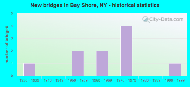
- New bridges - historical statistics
- 11930-1939
- 21950-1959
- 21960-1969
- 41970-1979
- 11990-1999


- Bridge Condition - Deck
- 50.0%Good
- 50.0%Satisfactory

- Bridge Condition - Superstructure
- 66.7%Good
- 33.3%Satisfactory

- Bridge Condition - Substructure
- 16.7%Very good
- 33.3%Good
- 50.0%Satisfactory
Find on map >> Show street view
Structure Number: 105613, Location: 2.9 MI NE JCT RTS 231+27 (Lat: 40.732819, Lng: -73.261733), Route carried "on" structure: Other road , Year Built: 1972, Status: Open, Structure Length: 7.71m (25.30ft), Average Daily Traffic: 22,857 (year 2020), Truck Traffic: 6%, Average Future Daily Traffic: 27,766 (year 2040), Design Load: HS 20, Features Intersected: 27 27 07051095 WB, 27 27, Facility Carried by Structure: FIFTH AV
Minimum Vertical Clearance: 30+ m (98+ ft), Kilometerpoint: 1.754, Lanes on structure: 6, Lanes under structure: 12, Owner: State Highway Agency, Approaching Roadway Width: 23.2m (76.1ft), Material/Design: Steel, Design/Construction: Stringer/Multi-beam, Number Of Spans In Main Unit: 4, Length of Maximum Span: 20.7m (67.9ft), Curb or Sidewalk Widths: Left: 1.6m (5.2ft), Right: 1.6m (5.2ft), Curb-To-Curb Width: 23.2m (76.1ft), Out-to-Out Width: 27.0m (88.6ft)
Condition: Deck: Satisfactory, Superstructure: Good, Substructure: Satisfactory, Operating Rating: 82.6 metric tons, Method Used To Determine Operating Rating: Load Factor (LF), Inventory Rating: 49.0 metric tons, Method Used To Determine Inventory Rating: Load Factor (LF), Structural Evaluation: Equal to present minimum criteria, Deck Geometry: Meets minimum limits, Underclear: High priority of corrective action, Approach Roadway Alignment: Better than present minimum criteria, Length Of Structure Improvement: 7.71m (25.30ft), Designated Inspection Frequency: Every 24 months, Inspection Date: June 2021, Bridge Improvement Cost: $8,383,000, Roadway Improvement Cost: $4,909,000, Total Project Cost: $13,293,000 ( Estimate for 2021), Deck Structure Type: Concrete Cast-file-Place, Wearing Surface/Protective System: Wearing Surface: Integral Concrete
Find on map >> Show street view
Structure Number: 105614, Location: 2.1 MI W JCT RTS 27+111 (Lat: 40.735656, Lng: -73.247658), Route carried "on" structure: Other road , Year Built: 1970, Status: Open, Structure Length: 8.14m (26.71ft), Average Daily Traffic: 9,344 (year 2019), Truck Traffic: 3%, Average Future Daily Traffic: 11,561 (year 2040), Design Load: HS 20, Features Intersected: 27 27 07051103 , W/B- Se, Facility Carried by Structure: BROOK AVE
Minimum Vertical Clearance: 30+ m (98+ ft), Kilometerpoint: 1.110, Lanes on structure: 4, Lanes under structure: 12, Owner: State Highway Agency, Approaching Roadway Width: 15.8m (51.8ft), Skew: 1 degrees, Material/Design: Steel, Design/Construction: Stringer/Multi-beam, Number Of Spans In Main Unit: 4, Length of Maximum Span: 22.5m (73.8ft), Curb or Sidewalk Widths: Left: 1.6m (5.2ft), Right: 1.6m (5.2ft), Curb-To-Curb Width: 15.8m (51.8ft), Out-to-Out Width: 19.7m (64.6ft)
Condition: Deck: Good, Superstructure: Good, Substructure: Good, Operating Rating: 84.4 metric tons, Method Used To Determine Operating Rating: Load Factor (LF), Inventory Rating: 49.9 metric tons, Method Used To Determine Inventory Rating: Load Factor (LF), Structural Evaluation: Better than present minimum criteria, Deck Geometry: Meets minimum limits, Underclear: High priority of corrective action, Approach Roadway Alignment: Equal to present desirable criteria, Length Of Structure Improvement: 8.13m (26.67ft), Designated Inspection Frequency: Every 24 months, Inspection Date: August 2021, Bridge Improvement Cost: $6,471,000, Roadway Improvement Cost: $3,790,000, Total Project Cost: $10,261,000 ( Estimate for 2021), Deck Structure Type: Concrete Cast-file-Place, Wearing Surface/Protective System: Wearing Surface: Monolithic Concrete
Find on map >> Show street view
Structure Number: 1058879, Location: 2 MI E JCT RTS 231+SSP (Lat: 40.737042, Lng: -73.283819), Route carried "on" structure: Other road , Year Built: 1950, Status: Open, Structure Length: 1.58m (5.18ft), Average Daily Traffic: 22,202 (year 2020), Truck Traffic: 4%, Average Future Daily Traffic: 26,970 (year 2040), Design Load: H 20, Features Intersected: RMC NB TO SSP EB, Facility Carried by Structure: BAY SHORE ROAD
Minimum Vertical Clearance: 30+ m (98+ ft), Kilometerpoint: 3.829, Lanes on structure: 3, Lanes under structure: 1, Owner: State Highway Agency, Approaching Roadway Width: 13.4m (44.0ft), Skew: 22 degrees, Material/Design: Concrete, Design/Construction: Frame, Number Of Spans In Main Unit: 1, Length of Maximum Span: 13.7m (44.9ft), Curb or Sidewalk Widths: Left: 2.4m (7.9ft), Right: 2.4m (7.9ft), Curb-To-Curb Width: 13.4m (44.0ft), Out-to-Out Width: 19.8m (65.0ft)
Condition: Deck: Satisfactory, Superstructure: Satisfactory, Substructure: Good, Operating Rating: 58.0 metric tons, Method Used To Determine Operating Rating: Field evaluation and documented engineering judgment, Inventory Rating: 23.9 metric tons, Method Used To Determine Inventory Rating: Field evaluation and documented engineering judgment, Structural Evaluation: Somewhat better than minimum adequacy, Deck Geometry: Somewhat better than minimum adequacy, Underclear: High priority of corrective action, Approach Roadway Alignment: Equal to present desirable criteria, Length Of Structure Improvement: 1.58m (5.18ft), Designated Inspection Frequency: Every 24 months, Inspection Date: October 2021, Bridge Improvement Cost: $2,032,000, Roadway Improvement Cost: $1,190,000, Total Project Cost: $3,222,000 ( Estimate for 2021), Wearing Surface/Protective System: Wearing Surface: Bituminous, Membrane: Preformed Fabric
Find on map >> Show street view
Structure Number: 1059859, Location: 2 MI E JCT RTS 231+SSP (Lat: 40.737678, Lng: -73.284894), Route carried "on" structure: County highway , Year Built: 1961, Status: Open, Structure Length: 2.01m (6.59ft), Average Daily Traffic: 22,202 (year 2020), Truck Traffic: 4%, Average Future Daily Traffic: 26,970 (year 2040), Design Load: HS 20, Features Intersected: RTE 908M, Facility Carried by Structure: BAY SHORE ROAD
Minimum Vertical Clearance: 30+ m (98+ ft), Kilometerpoint: 3.701, Lanes on structure: 4, Lanes under structure: 4, Owner: State Highway Agency, Approaching Roadway Width: 13.4m (44.0ft), Skew: 21 degrees, Material/Design: Concrete, Design/Construction: Frame, Number Of Spans In Main Unit: 1, Length of Maximum Span: 18.5m (60.7ft), Curb or Sidewalk Widths: Left: 2.4m (7.9ft), Right: 2.4m (7.9ft), Curb-To-Curb Width: 13.4m (44.0ft), Out-to-Out Width: 19.8m (65.0ft)
Condition: Deck: Satisfactory, Superstructure: Satisfactory, Substructure: Satisfactory, Operating Rating: 85.8 metric tons, Method Used To Determine Operating Rating: Field evaluation and documented engineering judgment, Inventory Rating: 32.7 metric tons, Method Used To Determine Inventory Rating: Field evaluation and documented engineering judgment, Structural Evaluation: Equal to present minimum criteria, Deck Geometry: High priority of replacement, Underclear: High priority of corrective action, Approach Roadway Alignment: Equal to present desirable criteria, Length Of Structure Improvement: 2.01m (6.59ft), Designated Inspection Frequency: Every 24 months, Inspection Date: November 2021, Bridge Improvement Cost: $2,505,000, Roadway Improvement Cost: $1,467,000, Total Project Cost: $3,971,000 ( Estimate for 2021), Wearing Surface/Protective System: Wearing Surface: Bituminous, Membrane: Preformed Fabric
Find on map >> Show street view
Structure Number: 330055, Location: SOUTH OF BAYSHORE (Lat: 40.717686, Lng: -73.234311), Route carried "on" structure: City street , Year Built: 1991, Status: Open, Structure Length: 1.16m (3.81ft), Average Daily Traffic: 283 (year 2018), Truck Traffic: 6%, Average Future Daily Traffic: 396 (year 2038), Design Load: HS 20, Features Intersected: AWIXA-PENATAQ.CNL, Facility Carried by Structure: AWIXA AVENUE
Minimum Vertical Clearance: 30+ m (98+ ft), Kilometerpoint: 0.402, Lanes on structure: 2, Owner: County Highway Agency, Approaching Roadway Width: 6.7m (22.0ft), Skew: 1 degrees, Material/Design: Prestressed concrete, Design/Construction: Slab, Number Of Spans In Main Unit: 1, Length of Maximum Span: 11.2m (36.7ft), Curb or Sidewalk Widths: Left: 1.5m (4.9ft), Right: 1.5m (4.9ft), Curb-To-Curb Width: 6.7m (22.0ft), Out-to-Out Width: 10.4m (34.1ft)
Condition: Deck: Good, Superstructure: Good, Substructure: Very good, Channel: Satisfactory, Inventory Rating: 93.4 metric tons, Method Used To Determine Inventory Rating: Load Factor (LF), Structural Evaluation: Better than present minimum criteria, Deck Geometry: Meets minimum limits, Waterway Adequacy: Somewhat better than minimum adequacy, Approach Roadway Alignment: Equal to present desirable criteria, Length Of Structure Improvement: 1.15m (3.77ft), Designated Inspection Frequency: Every 24 months, Inspection Date: August 2021, Bridge Improvement Cost: $338,000, Roadway Improvement Cost: $198,000, Total Project Cost: $536,000 ( Estimate for 2021), Wearing Surface/Protective System: Wearing Surface: Monolithic Concrete
Find on map >> Show street view
Structure Number: 330057, Location: SOUTH OF BAYSHORE (Lat: 40.717628, Lng: -73.236542), Route carried "on" structure: Other road , Year Built: 1932, Year Reconstructed: 1989, Status: Posted for load-capacity, Structure Length: 1.13m (3.71ft), Average Daily Traffic: 182 (year 2019), Truck Traffic: 6%, Average Future Daily Traffic: 255 (year 2039), Design Load: HS 20, Features Intersected: AWIXA-PENATAQ.CNL, Facility Carried by Structure: PENATAQUIT AVE
Minimum Vertical Clearance: 30+ m (98+ ft), Kilometerpoint: 0.451, Lanes on structure: 2, Owner: County Highway Agency, Approaching Roadway Width: 6.7m (22.0ft), Material/Design: Prestressed concrete, Design/Construction: Box Beam or Girders - Multiple, Number Of Spans In Main Unit: 1, Length of Maximum Span: 10.3m (33.8ft), Curb or Sidewalk Widths: Left: 1.5m (4.9ft), Right: 1.5m (4.9ft), Curb-To-Curb Width: 6.7m (22.0ft), Out-to-Out Width: 10.4m (34.1ft)
Condition: Deck: Good, Superstructure: Good, Substructure: Satisfactory, Channel: Satisfactory, Inventory Rating: 49.9 metric tons, Method Used To Determine Inventory Rating: Load Factor (LF), Structural Evaluation: Equal to present minimum criteria, Deck Geometry: Meets minimum limits, Waterway Adequacy: Equal to present desirable criteria, Approach Roadway Alignment: Equal to present desirable criteria, Length Of Structure Improvement: 1.12m (3.67ft), Designated Inspection Frequency: Every 24 months, Underwater Inspection Frequency: Every 60 months, Inspection Date: April 2020, Underwater Inspection Date: July 2021, Bridge Improvement Cost: $555,000, Roadway Improvement Cost: $325,000, Total Project Cost: $880,000 ( Estimate for 2021), Wearing Surface/Protective System: Wearing Surface: Integral Concrete
Find on map >> Show street view
Structure Number: 105613, Location: 2.9 MI NE JCT RTS 231+27 (Lat: 40.732819, Lng: -73.261733), Route carried "under" structure: State highway 27, Year Built: 1972, Structure Length: 0. m, Average Daily Traffic: 42,400 (year 1977), Features Intersected: 27 27 07051095 WB, 27 27, Facility Carried by Structure: FIFTH AV
Minimum Vertical Clearance: 4.55m (14.93ft), Kilometerpoint: 15.318, Lanes on structure: 6, Lanes under structure: 3, Material/Design: Steel, Design/Construction: Stringer/Multi-beam, Length of Maximum Span: 20.7m (67.9ft)
Find on map >> Show street view
Structure Number: 105614, Location: 2.1 MI W JCT RTS 27+111 (Lat: 40.735656, Lng: -73.247658), Route carried "under" structure: State highway 27, Year Built: 1970, Structure Length: 0. m, Average Daily Traffic: 30,200 (year 1977), Features Intersected: 27 27 07051103 , W/B- Se, Facility Carried by Structure: BROOK AVE
Minimum Vertical Clearance: 4.52m (14.83ft), Kilometerpoint: 16.428, Lanes on structure: 4, Lanes under structure: 3, Material/Design: Steel, Design/Construction: Stringer/Multi-beam, Length of Maximum Span: 22.5m (73.8ft)
Find on map >> Show street view
Structure Number: 1058879, Location: 2 MI E JCT RTS 231+SSP (Lat: 40.737042, Lng: -73.283819), Route carried "under" structure: Ramp City street , Year Built: 1950, Structure Length: 0. m, Average Daily Traffic: 6,000 (year 2021), Features Intersected: RMC NB TO SSP EB, Facility Carried by Structure: BAY SHORE ROAD
Minimum Vertical Clearance: 4.06m (13.32ft), Kilometerpoint: 0.000, Lanes on structure: 3, Lanes under structure: 1, Material/Design: Concrete, Design/Construction: Frame, Length of Maximum Span: 13.7m (44.9ft)
Find on map >> Show street view
Structure Number: 1059859, Location: 2 MI E JCT RTS 231+SSP (Lat: 40.737678, Lng: -73.284894), Route carried "under" structure: State highway 908M, Year Built: 1961, Structure Length: 0. m, Average Daily Traffic: 129,013 (year 2002), Features Intersected: RTE 908M, Facility Carried by Structure: BAY SHORE ROAD
Minimum Vertical Clearance: 4.57m (14.99ft), Kilometerpoint: 13.001, Lanes on structure: 4, Lanes under structure: 4, Material/Design: Concrete, Design/Construction: Frame, Length of Maximum Span: 18.5m (60.7ft)