Bridge Statistics for Bainbridge, New York (NY)
Condition, Traffic, Stress, Structural Evaluation, Project Costs
- National Bridge Inventory (NBI) Statistics
- 22Number of bridges
- 190ft / 58.1mTotal length
- $28,361,000Total costs
- 60,225Total average daily traffic
- 10,538Total average daily truck traffic
- National Bridge Inventory (NBI) Registered Bridges for Bainbridge
- No street view available for this location
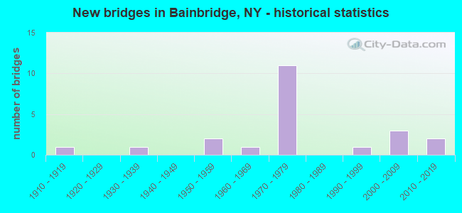
- New bridges - historical statistics
- 11910-1919
- 11930-1939
- 21950-1959
- 11960-1969
- 111970-1979
- 11990-1999
- 32000-2009
- 22010-2019

- Reconstructed bridges - Historical Statistics
- 11960-1969
- 01970-1979
- 11980-1989
- 01990-1999
- 12000-2009
- 12010-2019


- Bridge Condition - Deck
- 8.3%Excellent
- 25.0%Very good
- 25.0%Good
- 33.3%Satisfactory
- 8.3%Fair

- Bridge Condition - Superstructure
- 8.3%Excellent
- 25.0%Very good
- 25.0%Good
- 41.7%Satisfactory

- Bridge Condition - Substructure
- 8.3%Very good
- 25.0%Good
- 33.3%Satisfactory
- 33.3%Fair

- Bridge Condition - Channel
- 7.7%Very good
- 7.7%Good
- 23.1%Satisfactory
- 61.5%Fair

- Bridge Condition - Culverts
- 33.3%Very good
- 16.7%Satisfactory
- 50.0%Fair
Find on map >> Show street view
Structure Number: 100382, Location: 0.4 MI SW JCT RTS 7 & 206 (Lat: 42.285664, Lng: -75.484342), Route carried "on" structure: State highway 7, Year Built: 1962, Status: Open, Structure Length: 6.07m (19.91ft), Average Daily Traffic: 1,530 (year 2019), Truck Traffic: 6%, Average Future Daily Traffic: 1,596 (year 2040), Design Load: H 20, Features Intersected: NORFOLK SOUTHERN RR
Minimum Vertical Clearance: 30+ m (98+ ft), Kilometerpoint: 16.653, Lanes on structure: 2, Base Highway Network: Yes, Owner: State Highway Agency, Approaching Roadway Width: 8.5m (27.9ft), Material/Design: Steel, Design/Construction: Girder and Floorbeam System, Number Of Spans In Main Unit: 2, Length of Maximum Span: 29.5m (96.8ft), Curb-To-Curb Width: 9.0m (29.5ft), Out-to-Out Width: 10.7m (35.1ft)
Condition: Deck: Satisfactory, Superstructure: Satisfactory, Substructure: Satisfactory, Operating Rating: 58.1 metric tons, Method Used To Determine Operating Rating: Load Factor (LF), Inventory Rating: 34.5 metric tons, Method Used To Determine Inventory Rating: Load Factor (LF), Structural Evaluation: Equal to present minimum criteria, Deck Geometry: Somewhat better than minimum adequacy, Underclear: Meets minimum limits, Approach Roadway Alignment: Equal to present desirable criteria, Length Of Structure Improvement: 6.06m (19.88ft), Designated Inspection Frequency: Every 24 months, Critical Feature Inspection Frequency: Every 24 months, Inspection Date: June 2020, Critical Feature Inspection Date: June 2020, Bridge Improvement Cost: $2,090,000, Roadway Improvement Cost: $1,224,000, Total Project Cost: $3,314,000 ( Estimate for 2021), Deck Structure Type: Concrete Cast-file-Place, Wearing Surface/Protective System: Wearing Surface: Monolithic Concrete
Find on map >> Show street view
Structure Number: 100383, Location: .5 MI NE JCT SH 7 & SH 20 (Lat: 42.295122, Lng: -75.477419), Route carried "on" structure: State highway 7, Year Built: 2009, Status: Open, Structure Length: 0.67m (2.20ft), Average Daily Traffic: 4,404 (year 2018), Truck Traffic: 6%, Average Future Daily Traffic: 4,594 (year 2040), Design Load: HS 25 or greater, Features Intersected: Newton Creek
Minimum Vertical Clearance: 30+ m (98+ ft), Kilometerpoint: 17.956, Lanes on structure: 2, Base Highway Network: Yes, Owner: State Highway Agency, Approaching Roadway Width: 8.5m (27.9ft), Skew: 1 degrees, Material/Design: Concrete, Design/Construction: Culvert, Number Of Spans In Main Unit: 1, Length of Maximum Span: 5.8m (19.0ft), Curb or Sidewalk Widths: Left: 4.1m (13.5ft), Right: 3.2m (10.5ft), Curb-To-Curb Width: 8.4m (27.6ft), Out-to-Out Width: 16.4m (53.8ft)
Condition: Channel: Very good, Culverts: Very good, Operating Rating: 48.1 metric tons, Method Used To Determine Operating Rating: Load Factor (LF), Inventory Rating: 28.1 metric tons, Method Used To Determine Inventory Rating: Load Factor (LF), Structural Evaluation: Better than present minimum criteria, Deck Geometry: High priority of corrective action, Waterway Adequacy: Equal to present desirable criteria, Approach Roadway Alignment: Equal to present desirable criteria, Length Of Structure Improvement: 0.67m (2.20ft), Designated Inspection Frequency: Every 24 months, Inspection Date: May 2020, Bridge Improvement Cost: $195,000, Roadway Improvement Cost: $114,000, Total Project Cost: $309,000 ( Estimate for 2021), Wearing Surface/Protective System: Wearing Surface: Bituminous, Membrane: Other
Find on map >> Show street view
Structure Number: 100384, Location: 1 MI NE JCT SH 7 & SH 206 (Lat: 42.302628, Lng: -75.464208), Route carried "on" structure: State highway 7, Year Built: 1910, Year Reconstructed: 1973, Status: Open, Structure Length: 1.31m (4.30ft), Average Daily Traffic: 3,094 (year 2015), Truck Traffic: 7%, Average Future Daily Traffic: 3,227 (year 2040), Features Intersected: YALEVILLE BROOK
Minimum Vertical Clearance: 30+ m (98+ ft), Kilometerpoint: 19.388, Lanes on structure: 2, Base Highway Network: Yes, Owner: State Highway Agency, Approaching Roadway Width: 11.0m (36.1ft), Material/Design: Steel, Design/Construction: Stringer/Multi-beam, Number Of Spans In Main Unit: 1, Length of Maximum Span: 12.8m (42.0ft), Curb-To-Curb Width: 11.1m (36.4ft), Out-to-Out Width: 11.7m (38.4ft)
Condition: Deck: Fair, Superstructure: Satisfactory, Substructure: Fair, Channel: Fair, Operating Rating: 58.1 metric tons, Method Used To Determine Operating Rating: Load Factor (LF), Inventory Rating: 22.7 metric tons, Method Used To Determine Inventory Rating: Load Factor (LF), Structural Evaluation: Somewhat better than minimum adequacy, Deck Geometry: Somewhat better than minimum adequacy, Waterway Adequacy: Somewhat better than minimum adequacy, Approach Roadway Alignment: Meets minimum limits, Length Of Structure Improvement: 1.31m (4.30ft), Designated Inspection Frequency: Every 24 months, Inspection Date: September 2020, Bridge Improvement Cost: $474,000, Roadway Improvement Cost: $278,000, Total Project Cost: $751,000 ( Estimate for 2021), Deck Structure Type: Concrete Cast-file-Place, Wearing Surface/Protective System: Wearing Surface: Bituminous
Find on map >> Show street view
Structure Number: 104038, Location: 3.4 MI NW JCT RTS 206 + 7 (Lat: 42.313708, Lng: -75.537936), Route carried "on" structure: State highway 206, Year Built: 2014, Status: Open, Structure Length: 1.34m (4.40ft), Average Daily Traffic: 2,968 (year 2017), Truck Traffic: 8%, Average Future Daily Traffic: 2,986 (year 2040), Design Load: HL 93, Features Intersected: KELSEY CREEK
Minimum Vertical Clearance: 30+ m (98+ ft), Kilometerpoint: 27.981, Lanes on structure: 2, Base Highway Network: Yes, Owner: State Highway Agency, Approaching Roadway Width: 10.1m (33.1ft), Skew: 4 degrees, Material/Design: Concrete, Design/Construction: Culvert, Number Of Spans In Main Unit: 1, Length of Maximum Span: 12.8m (42.0ft), Curb-To-Curb Width: 10.2m (33.5ft), Out-to-Out Width: 11.2m (36.7ft)
Condition: Channel: Fair, Culverts: Very good, Operating Rating: 61.7 metric tons, Method Used To Determine Operating Rating: Load Factor (LF), Inventory Rating: 37.2 metric tons, Method Used To Determine Inventory Rating: Load Factor (LF), Structural Evaluation: Equal to present desirable criteria, Deck Geometry: Meets minimum limits, Waterway Adequacy: Equal to present desirable criteria, Approach Roadway Alignment: Equal to present desirable criteria, Length Of Structure Improvement: 1.34m (4.40ft), Designated Inspection Frequency: Every 24 months, Inspection Date: October 2020, Bridge Improvement Cost: $266,000, Roadway Improvement Cost: $156,000, Total Project Cost: $421,000 ( Estimate for 2021), Wearing Surface/Protective System: Wearing Surface: Bituminous
Find on map >> Show street view
Structure Number: 104039, Location: JCT RTE 206+SUSQUEHANNA R (Lat: 42.291781, Lng: -75.476481), Route carried "on" structure: State highway 206, Year Built: 1953, Year Reconstructed: 2007, Status: Open, Structure Length: 15.39m (50.49ft), Average Daily Traffic: 5,993 (year 2018), Truck Traffic: 6%, Average Future Daily Traffic: 6,030 (year 2040), Design Load: HS 25 or greater, Features Intersected: SUSQUEHANNA RIVER
Minimum Vertical Clearance: 30+ m (98+ ft), Kilometerpoint: 33.869, Lanes on structure: 2, Base Highway Network: Yes, Owner: State Highway Agency, Approaching Roadway Width: 8.8m (28.9ft), Material/Design: Steel continuous, Design/Construction: Stringer/Multi-beam, Number Of Spans In Main Unit: 3, Length of Maximum Span: 57.9m (190.0ft), Curb or Sidewalk Widths: Left: 1.6m (5.2ft), Right: 1.6m (5.2ft), Curb-To-Curb Width: 8.7m (28.5ft), Out-to-Out Width: 12.8m (42.0ft)
Condition: Deck: Good, Superstructure: Very good, Substructure: Good, Channel: Satisfactory, Operating Rating: 72.6 metric tons, Method Used To Determine Operating Rating: Load Factor (LF), Inventory Rating: 43.5 metric tons, Method Used To Determine Inventory Rating: Load Factor (LF), Structural Evaluation: Better than present minimum criteria, Deck Geometry: Meets minimum limits, Waterway Adequacy: Somewhat better than minimum adequacy, Approach Roadway Alignment: Equal to present desirable criteria, Length Of Structure Improvement: 15.39m (50.49ft), Designated Inspection Frequency: Every 24 months, Underwater Inspection Frequency: Every 60 months, Inspection Date: October 2021, Underwater Inspection Date: June 2021, Bridge Improvement Cost: $4,453,000, Roadway Improvement Cost: $2,608,000, Total Project Cost: $7,061,000 ( Estimate for 2021), Deck Structure Type: Concrete Cast-file-Place, Wearing Surface/Protective System: Wearing Surface: Integral Concrete, Deck Protection: Epoxy Coated Reinforcing
Find on map >> Show street view
Structure Number: 10404, Location: 3.2 MI SE JCT SH 206 & SH (Lat: 42.257700, Lng: -75.448242), Route carried "on" structure: State highway 206, Year Built: 1959, Year Reconstructed: 1993, Status: Open, Structure Length: 7.28m (23.88ft), Average Daily Traffic: 1,297 (year 2016), Truck Traffic: 9%, Average Future Daily Traffic: 1,305 (year 2040), Design Load: HS 25 or greater, Features Intersected: BIG BROOK
Minimum Vertical Clearance: 30+ m (98+ ft), Kilometerpoint: 38.600, Lanes on structure: 2, Base Highway Network: Yes, Owner: State Highway Agency, Approaching Roadway Width: 9.8m (32.2ft), Skew: 5 degrees, Material/Design: Steel continuous, Design/Construction: Stringer/Multi-beam, Number Of Spans In Main Unit: 3, Length of Maximum Span: 24.0m (78.7ft), Curb-To-Curb Width: 9.8m (32.2ft), Out-to-Out Width: 10.4m (34.1ft)
Condition: Deck: Satisfactory, Superstructure: Good, Substructure: Satisfactory, Channel: Satisfactory, Operating Rating: 83.5 metric tons, Method Used To Determine Operating Rating: Load Factor (LF), Inventory Rating: 49.9 metric tons, Method Used To Determine Inventory Rating: Load Factor (LF), Structural Evaluation: Equal to present minimum criteria, Deck Geometry: Somewhat better than minimum adequacy, Waterway Adequacy: Somewhat better than minimum adequacy, Approach Roadway Alignment: Equal to present desirable criteria, Length Of Structure Improvement: 7.28m (23.88ft), Designated Inspection Frequency: Every 24 months, Inspection Date: August 2020, Bridge Improvement Cost: $1,921,000, Roadway Improvement Cost: $1,125,000, Total Project Cost: $3,046,000 ( Estimate for 2021), Deck Structure Type: Concrete Cast-file-Place, Wearing Surface/Protective System: Wearing Surface: Integral Concrete, Deck Protection: Epoxy Coated Reinforcing
Find on map >> Show street view
Structure Number: 10773, Location: 1 MI S JCT I88 & SH 206 (Lat: 42.275656, Lng: -75.469558), Route carried "on" structure: Interstate 88, Year Built: 1974, Status: Open, Structure Length: 0.76m (2.49ft), Average Daily Traffic: 7,736 (year 2019), Truck Traffic: 26%, Average Future Daily Traffic: 9,213 (year 2040), Design Load: HS 20, Features Intersected: UNNAMED CREEK, UNNAMED C
Minimum Vertical Clearance: 30+ m (98+ ft), Kilometerpoint: 14.642, Lanes on structure: 4, Base Highway Network: Yes, Owner: State Highway Agency, Approaching Roadway Width: 12.8m (42.0ft), Skew: 20 degrees, Material/Design: Steel, Design/Construction: Culvert, Number Of Spans In Main Unit: 2, Length of Maximum Span: 3.4m (11.2ft)
Condition: Channel: Satisfactory, Culverts: Fair, Operating Rating: 73.9 metric tons, Method Used To Determine Operating Rating: Field evaluation and documented engineering judgment, Inventory Rating: 19.6 metric tons, Method Used To Determine Inventory Rating: Field evaluation and documented engineering judgment, Structural Evaluation: Meets minimum limits, Waterway Adequacy: Superior to present desirable criteria, Approach Roadway Alignment: Equal to present desirable criteria, Length Of Structure Improvement: 0.76m (2.49ft), Designated Inspection Frequency: Every 24 months, Inspection Date: September 2021, Bridge Improvement Cost: $173,000, Roadway Improvement Cost: $101,000, Total Project Cost: $274,000 ( Estimate for 2021)
Find on map >> Show street view
Structure Number: 1094961, Location: 23 MI S JCT RTS I-88+206 (Lat: 42.256939, Lng: -75.472361), Route carried "on" structure: Interstate 88, Year Built: 1974, Status: Open, Structure Length: 3.47m (11.38ft), Average Daily Traffic: 4,926 (year 2014), Truck Traffic: 28%, Design Load: HS 20, Features Intersected: CORBIN ROAD
Minimum Vertical Clearance: 30+ m (98+ ft), Kilometerpoint: 12.421, Lanes on structure: 2, Lanes under structure: 2, Base Highway Network: Yes, Owner: State Highway Agency, Approaching Roadway Width: 12.5m (41.0ft), Skew: 3 degrees, Material/Design: Steel, Design/Construction: Stringer/Multi-beam, Number Of Spans In Main Unit: 1, Length of Maximum Span: 34.1m (111.9ft), Curb-To-Curb Width: 12.5m (41.0ft), Out-to-Out Width: 13.4m (44.0ft)
Condition: Deck: Good, Superstructure: Satisfactory, Substructure: Fair, Operating Rating: 76.8 metric tons, Method Used To Determine Operating Rating: Load and Resistance Factor Rating (LRFR) rating reported by rating factor(RF) method using HL-93 loadings, Inventory Rating: 59.3 metric tons, Method Used To Determine Inventory Rating: Load and Resistance Factor Rating (LRFR) rating reported by rating factor(RF) method using HL-93 loadings, Structural Evaluation: Somewhat better than minimum adequacy, Deck Geometry: Better than present minimum criteria, Underclear: Somewhat better than minimum adequacy, Approach Roadway Alignment: Equal to present desirable criteria, Length Of Structure Improvement: 3.47m (11.38ft), Designated Inspection Frequency: Every 24 months, Inspection Date: September 2021, Bridge Improvement Cost: $1,261,000, Roadway Improvement Cost: $739,000, Total Project Cost: $2,000,000 ( Estimate for 2021), Deck Structure Type: Concrete Cast-file-Place, Wearing Surface/Protective System: Wearing Surface: Monolithic Concrete
Find on map >> Show street view
Structure Number: 1094962, Location: 23 MI S JCT RTS I-88+206 (Lat: 42.256917, Lng: -75.471944), Route carried "on" structure: Interstate 88, Year Built: 1974, Status: Open, Structure Length: 3.47m (11.38ft), Average Daily Traffic: 3,868 (year 2019), Truck Traffic: 26%, Average Future Daily Traffic: 4,607 (year 2040), Design Load: HS 20, Features Intersected: CORBIN ROAD
Minimum Vertical Clearance: 30+ m (98+ ft), Kilometerpoint: 12.421, Lanes on structure: 2, Lanes under structure: 2, Base Highway Network: Yes, Owner: State Highway Agency, Approaching Roadway Width: 12.5m (41.0ft), Skew: 3 degrees, Material/Design: Steel, Design/Construction: Stringer/Multi-beam, Number Of Spans In Main Unit: 1, Length of Maximum Span: 34.1m (111.9ft), Curb-To-Curb Width: 12.5m (41.0ft), Out-to-Out Width: 13.4m (44.0ft)
Condition: Deck: Satisfactory, Superstructure: Satisfactory, Substructure: Satisfactory, Operating Rating: 85.9 metric tons, Method Used To Determine Operating Rating: Load and Resistance Factor Rating (LRFR) rating reported by rating factor(RF) method using HL-93 loadings, Inventory Rating: 66.1 metric tons, Method Used To Determine Inventory Rating: Load and Resistance Factor Rating (LRFR) rating reported by rating factor(RF) method using HL-93 loadings, Structural Evaluation: Equal to present minimum criteria, Deck Geometry: Better than present minimum criteria, Underclear: Somewhat better than minimum adequacy, Approach Roadway Alignment: Equal to present desirable criteria, Length Of Structure Improvement: 3.47m (11.38ft), Designated Inspection Frequency: Every 24 months, Inspection Date: September 2021, Bridge Improvement Cost: $1,261,000, Roadway Improvement Cost: $739,000, Total Project Cost: $2,000,000 ( Estimate for 2021), Deck Structure Type: Concrete Cast-file-Place, Wearing Surface/Protective System: Wearing Surface: Monolithic Concrete
Find on map >> Show street view
Structure Number: 1094971, Location: 2 MI S JCT I88 + SH 206 (Lat: 42.261181, Lng: -75.469094), Route carried "on" structure: Interstate 88, Year Built: 1974, Status: Open, Structure Length: 2.13m (6.99ft), Average Daily Traffic: 4,926 (year 2014), Truck Traffic: 28%, Average Future Daily Traffic: 6,896 (year 2034), Design Load: HS 20, Features Intersected: BIG BROOK
Minimum Vertical Clearance: 30+ m (98+ ft), Kilometerpoint: 12.985, Lanes on structure: 2, Base Highway Network: Yes, Owner: State Highway Agency, Approaching Roadway Width: 12.5m (41.0ft), Skew: 2 degrees, Material/Design: Concrete, Design/Construction: Culvert, Number Of Spans In Main Unit: 3, Length of Maximum Span: 7.0m (23.0ft), Curb-To-Curb Width: 12.9m (42.3ft), Out-to-Out Width: 13.5m (44.3ft)
Condition: Channel: Fair, Culverts: Fair, Operating Rating: 73.5 metric tons, Method Used To Determine Operating Rating: Load Factor (LF), Inventory Rating: 43.5 metric tons, Method Used To Determine Inventory Rating: Load Factor (LF), Structural Evaluation: Somewhat better than minimum adequacy, Deck Geometry: Superior to present desirable criteria, Waterway Adequacy: Equal to present desirable criteria, Approach Roadway Alignment: Equal to present desirable criteria, Length Of Structure Improvement: 2.13m (6.99ft), Designated Inspection Frequency: Every 24 months, Inspection Date: April 2020, Bridge Improvement Cost: $570,000, Roadway Improvement Cost: $334,000, Total Project Cost: $904,000 ( Estimate for 2021), Wearing Surface/Protective System: Wearing Surface: Bituminous
Find on map >> Show street view
Structure Number: 1094972, Location: 2 MI S JCT I88 & SH 206 (Lat: 42.261231, Lng: -75.468631), Route carried "on" structure: Interstate 88, Year Built: 1974, Status: Open, Structure Length: 2.13m (6.99ft), Average Daily Traffic: 3,868 (year 2019), Truck Traffic: 26%, Average Future Daily Traffic: 4,607 (year 2040), Design Load: HS 20, Features Intersected: BIG BROOK
Minimum Vertical Clearance: 30+ m (98+ ft), Kilometerpoint: 12.985, Lanes on structure: 2, Base Highway Network: Yes, Owner: State Highway Agency, Approaching Roadway Width: 12.2m (40.0ft), Skew: 2 degrees, Material/Design: Concrete, Design/Construction: Culvert, Number Of Spans In Main Unit: 3, Length of Maximum Span: 7.0m (23.0ft), Curb-To-Curb Width: 12.9m (42.3ft), Out-to-Out Width: 13.5m (44.3ft)
Condition: Channel: Fair, Culverts: Fair, Operating Rating: 73.5 metric tons, Method Used To Determine Operating Rating: Load Factor (LF), Inventory Rating: 43.5 metric tons, Method Used To Determine Inventory Rating: Load Factor (LF), Structural Evaluation: Somewhat better than minimum adequacy, Deck Geometry: Superior to present desirable criteria, Waterway Adequacy: Equal to present desirable criteria, Approach Roadway Alignment: Equal to present desirable criteria, Length Of Structure Improvement: 2.13m (6.99ft), Designated Inspection Frequency: Every 24 months, Inspection Date: April 2020, Bridge Improvement Cost: $570,000, Roadway Improvement Cost: $334,000, Total Project Cost: $904,000 ( Estimate for 2021), Wearing Surface/Protective System: Wearing Surface: Bituminous
Find on map >> Show street view
Structure Number: 1094981, Location: JCT RTS I-88 + 206 (Lat: 42.289200, Lng: -75.472508), Route carried "on" structure: Interstate 88, Year Built: 1974, Status: Open, Structure Length: 4.17m (13.68ft), Average Daily Traffic: 5,465 (year 2011), Truck Traffic: 21%, Average Future Daily Traffic: 7,651 (year 2031), Design Load: HS 20, Features Intersected: RTE 206
Minimum Vertical Clearance: 30+ m (98+ ft), Kilometerpoint: 16.154, Lanes on structure: 2, Lanes under structure: 3, Base Highway Network: Yes, Owner: State Highway Agency, Approaching Roadway Width: 12.1m (39.7ft), Skew: 1 degrees, Material/Design: Steel, Design/Construction: Stringer/Multi-beam, Number Of Spans In Main Unit: 1, Length of Maximum Span: 41.1m (134.8ft), Curb-To-Curb Width: 12.5m (41.0ft), Out-to-Out Width: 13.4m (44.0ft)
Condition: Deck: Very good, Superstructure: Good, Substructure: Good, Inventory Rating: 61.7 metric tons, Method Used To Determine Inventory Rating: Load Factor (LF), Structural Evaluation: Better than present minimum criteria, Deck Geometry: Better than present minimum criteria, Underclear: Somewhat better than minimum adequacy, Approach Roadway Alignment: Equal to present desirable criteria, Length Of Structure Improvement: 4.17m (13.68ft), Designated Inspection Frequency: Every 24 months, Inspection Date: August 2020, Bridge Improvement Cost: $1,672,000, Roadway Improvement Cost: $979,000, Total Project Cost: $2,651,000 ( Estimate for 2021), Deck Structure Type: Concrete Cast-file-Place, Wearing Surface/Protective System: Wearing Surface: Monolithic Concrete
Find on map >> Show street view
Structure Number: 1094982, Location: JCT RTS I-88 + 206 (Lat: 42.288894, Lng: -75.472072), Route carried "on" structure: Interstate 88, Year Built: 1974, Status: Open, Structure Length: 4.17m (13.68ft), Average Daily Traffic: 3,876 (year 2020), Truck Traffic: 31%, Average Future Daily Traffic: 4,615 (year 2040), Design Load: HS 20, Features Intersected: RTE 206
Minimum Vertical Clearance: 30+ m (98+ ft), Kilometerpoint: 16.154, Lanes on structure: 2, Lanes under structure: 3, Base Highway Network: Yes, Owner: State Highway Agency, Approaching Roadway Width: 12.1m (39.7ft), Skew: 1 degrees, Material/Design: Steel, Design/Construction: Stringer/Multi-beam, Number Of Spans In Main Unit: 1, Length of Maximum Span: 41.1m (134.8ft), Curb-To-Curb Width: 12.5m (41.0ft), Out-to-Out Width: 13.4m (44.0ft)
Condition: Deck: Satisfactory, Superstructure: Satisfactory, Substructure: Fair, Operating Rating: 84.4 metric tons, Method Used To Determine Operating Rating: Load Factor (LF), Inventory Rating: 50.8 metric tons, Method Used To Determine Inventory Rating: Load Factor (LF), Structural Evaluation: Somewhat better than minimum adequacy, Deck Geometry: Better than present minimum criteria, Underclear: Somewhat better than minimum adequacy, Approach Roadway Alignment: Equal to present desirable criteria, Length Of Structure Improvement: 4.17m (13.68ft), Designated Inspection Frequency: Every 24 months, Inspection Date: August 2020, Bridge Improvement Cost: $1,569,000, Roadway Improvement Cost: $919,000, Total Project Cost: $2,488,000 ( Estimate for 2021), Deck Structure Type: Concrete Cast-file-Place, Wearing Surface/Protective System: Wearing Surface: Monolithic Concrete
Find on map >> Show street view
Structure Number: 335018, Location: 1.7 MI N OF BAINBRIDGE (Lat: 42.325481, Lng: -75.469322), Route carried "on" structure: County highway , Year Built: 1935, Year Reconstructed: 2017, Status: Open, Structure Length: 1.13m (3.71ft), Average Daily Traffic: 923 (year 2018), Truck Traffic: 5%, Average Future Daily Traffic: 1,292 (year 2038), Features Intersected: YALEVILLE BROOK, Facility Carried by Structure: COUNTY ROAD 38
Minimum Vertical Clearance: 30+ m (98+ ft), Kilometerpoint: 2.703, Lanes on structure: 2, Owner: County Highway Agency, Approaching Roadway Width: 7.3m (24.0ft), Skew: 4 degrees, Material/Design: Concrete, Design/Construction: Box Beam or Girders - Multiple, Number Of Spans In Main Unit: 1, Length of Maximum Span: 11.0m (36.1ft), Curb-To-Curb Width: 8.4m (27.6ft), Out-to-Out Width: 9.2m (30.2ft)
Condition: Deck: Excellent, Superstructure: Excellent, Substructure: Satisfactory, Channel: Fair, Operating Rating: 64.4 metric tons, Method Used To Determine Operating Rating: Load Factor (LF), Inventory Rating: 38.1 metric tons, Method Used To Determine Inventory Rating: Load Factor (LF), Structural Evaluation: Equal to present minimum criteria, Deck Geometry: Somewhat better than minimum adequacy, Waterway Adequacy: Meets minimum limits, Approach Roadway Alignment: Equal to present desirable criteria, Length Of Structure Improvement: 1.15m (3.77ft), Designated Inspection Frequency: Every 24 months, Inspection Date: October 2021, Bridge Improvement Cost: $489,000, Roadway Improvement Cost: $286,000, Total Project Cost: $775,000 ( Estimate for 2021), Wearing Surface/Protective System: Wearing Surface: Bituminous, Membrane: Other
Find on map >> Show street view
Structure Number: 335019, Location: 2.3 MI S OF BAINBRIDGE (Lat: 42.261183, Lng: -75.473106), Route carried "on" structure: County highway , Year Built: 1990, Status: Open, Structure Length: 1.89m (6.20ft), Average Daily Traffic: 669 (year 2016), Truck Traffic: 8%, Average Future Daily Traffic: 937 (year 2036), Design Load: HS 20, Features Intersected: BIG BROOK, Facility Carried by Structure: CR 39
Minimum Vertical Clearance: 30+ m (98+ ft), Kilometerpoint: 5.342, Lanes on structure: 2, Owner: County Highway Agency, Approaching Roadway Width: 5.5m (18.0ft), Material/Design: Steel, Design/Construction: Stringer/Multi-beam, Number Of Spans In Main Unit: 1, Length of Maximum Span: 17.9m (58.7ft), Curb-To-Curb Width: 7.5m (24.6ft), Out-to-Out Width: 8.1m (26.6ft)
Condition: Deck: Good, Superstructure: Good, Substructure: Fair, Channel: Fair, Inventory Rating: 60.8 metric tons, Method Used To Determine Inventory Rating: Load Factor (LF), Structural Evaluation: Somewhat better than minimum adequacy, Deck Geometry: Meets minimum limits, Waterway Adequacy: Meets minimum limits, Approach Roadway Alignment: Equal to present desirable criteria, Length Of Structure Improvement: 1.88m (6.17ft), Designated Inspection Frequency: Every 24 months, Inspection Date: June 2020, Bridge Improvement Cost: $477,000, Roadway Improvement Cost: $279,000, Total Project Cost: $757,000 ( Estimate for 2021), Deck Structure Type: Corrugated Steel, Wearing Surface/Protective System: Wearing Surface: Bituminous
Find on map >> Show street view
Structure Number: 335021, Location: 4.0 MI WEST OF BAINBRIDGE (Lat: 42.288519, Lng: -75.535856), Route carried "on" structure: County highway , Year Built: 2000, Status: Open, Structure Length: 0.98m (3.22ft), Average Daily Traffic: 79 (year 2018), Truck Traffic: 6%, Average Future Daily Traffic: 111 (year 2038), Design Load: HS 25 or greater, Features Intersected: KELSEY CREEK, Facility Carried by Structure: CHASE ROAD
Minimum Vertical Clearance: 30+ m (98+ ft), Kilometerpoint: 0.434, Lanes on structure: 2, Toll: On Interstate toll segment, Owner: County Highway Agency, Approaching Roadway Width: 7.3m (24.0ft), Material/Design: Prestressed concrete, Design/Construction: Box Beam or Girders - Multiple, Number Of Spans In Main Unit: 1, Length of Maximum Span: 9.1m (29.9ft), Curb-To-Curb Width: 7.0m (23.0ft), Out-to-Out Width: 7.4m (24.3ft)
Condition: Deck: Very good, Superstructure: Very good, Substructure: Very good, Channel: Fair, Operating Rating: 73.5 metric tons, Method Used To Determine Operating Rating: Load Factor (LF), Inventory Rating: 43.5 metric tons, Method Used To Determine Inventory Rating: Load Factor (LF), Structural Evaluation: Equal to present desirable criteria, Deck Geometry: Somewhat better than minimum adequacy, Waterway Adequacy: Meets minimum limits, Approach Roadway Alignment: Meets minimum limits, Length Of Structure Improvement: 0.97m (3.18ft), Designated Inspection Frequency: Every 24 months, Inspection Date: June 2020, Bridge Improvement Cost: $294,000, Roadway Improvement Cost: $172,000, Total Project Cost: $466,000 ( Estimate for 2021), Wearing Surface/Protective System: Wearing Surface: Bituminous
Find on map >> Show street view
Structure Number: 337098, Location: .9 Mi N Jct Rt 206 (Lat: 42.327456, Lng: -75.541972), Route carried "on" structure: County highway , Year Built: 2012, Status: Open, Structure Length: 0.82m (2.69ft), Average Daily Traffic: 501 (year 2016), Truck Traffic: 5%, Average Future Daily Traffic: 701 (year 2036), Features Intersected: KELSEY CREEK, Facility Carried by Structure: COUNTY ROAD 17
Minimum Vertical Clearance: 30+ m (98+ ft), Kilometerpoint: 6.726, Lanes on structure: 2, Owner: County Highway Agency, Approaching Roadway Width: 10.4m (34.1ft), Skew: 2 degrees, Material/Design: Steel, Design/Construction: Culvert, Number Of Spans In Main Unit: 2, Length of Maximum Span: 3.7m (12.1ft)
Condition: Channel: Fair, Culverts: Satisfactory, Operating Rating: 75.1 metric tons, Method Used To Determine Operating Rating: Field evaluation and documented engineering judgment, Inventory Rating: 40.8 metric tons, Method Used To Determine Inventory Rating: Field evaluation and documented engineering judgment, Structural Evaluation: Equal to present minimum criteria, Waterway Adequacy: Equal to present minimum criteria, Approach Roadway Alignment: Equal to present desirable criteria, Length Of Structure Improvement: 0.82m (2.69ft), Designated Inspection Frequency: Every 24 months, Inspection Date: September 2020, Bridge Improvement Cost: $151,000, Roadway Improvement Cost: $88,000, Total Project Cost: $240,000 ( Estimate for 2021)
Find on map >> Show street view
Structure Number: 337175, Location: 1 Mi NW of NY 206 & NY 7 (Lat: 42.298008, Lng: -75.486431), Route carried "on" structure: Other road , Year Built: 2007, Status: Open, Structure Length: 0.91m (2.99ft), Features Intersected: NEWTON BROOK, Facility Carried by Structure: BIXBY STREET CONNE
Minimum Vertical Clearance: 32.69m (107.25ft), Kilometerpoint: 0.000, Lanes on structure: 2, Owner: County Highway Agency, Approaching Roadway Width: 8.5m (27.9ft), Material/Design: Concrete, Design/Construction: Frame, Number Of Spans In Main Unit: 1, Length of Maximum Span: 8.5m (27.9ft), Curb-To-Curb Width: 9.3m (30.5ft), Out-to-Out Width: 10.2m (33.5ft)
Condition: Deck: Very good, Superstructure: Very good, Substructure: Good, Channel: Good, Operating Rating: 78.7 metric tons, Method Used To Determine Operating Rating: Field evaluation and documented engineering judgment, Inventory Rating: 40.8 metric tons, Method Used To Determine Inventory Rating: Field evaluation and documented engineering judgment, Structural Evaluation: Better than present minimum criteria, Deck Geometry: Better than present minimum criteria, Waterway Adequacy: Equal to present desirable criteria, Approach Roadway Alignment: Equal to present desirable criteria, Designated Inspection Frequency: Every 24 months, Inspection Date: July 2021
Find on map >> Show street view
Structure Number: 1094961, Location: 23 MI S JCT RTS I-88+206 (Lat: 42.256939, Lng: -75.472361), Route carried "under" structure: County highway , Year Built: 1974, Structure Length: 0. m, Features Intersected: CORBIN ROAD, Facility Carried by Structure: RTE I88
Minimum Vertical Clearance: 4.70m (15.42ft), Kilometerpoint: 0.000, Lanes on structure: 2, Lanes under structure: 2, Material/Design: Steel, Design/Construction: Stringer/Multi-beam, Length of Maximum Span: 34.1m (111.9ft)
Find on map >> Show street view
Structure Number: 1094962, Location: 23 MI S JCT RTS I-88+206 (Lat: 42.256917, Lng: -75.471944), Route carried "under" structure: County highway , Year Built: 1974, Structure Length: 0. m, Features Intersected: CORBIN ROAD, Facility Carried by Structure: RTE I88
Minimum Vertical Clearance: 4.44m (14.57ft), Kilometerpoint: 0.064, Lanes on structure: 2, Lanes under structure: 2, Material/Design: Steel, Design/Construction: Stringer/Multi-beam, Length of Maximum Span: 34.1m (111.9ft)
Find on map >> Show street view
Structure Number: 1094981, Location: JCT RTS I-88 + 206 (Lat: 42.289200, Lng: -75.472508), Route carried "under" structure: US 206, Year Built: 1974, Structure Length: 0. m, Average Daily Traffic: 2,051 (year 2002), Features Intersected: RTE 206, Facility Carried by Structure: RTE I88
Minimum Vertical Clearance: 5.54m (18.18ft), Kilometerpoint: 34.465, Lanes on structure: 2, Lanes under structure: 3, Material/Design: Steel, Design/Construction: Stringer/Multi-beam, Length of Maximum Span: 41.1m (134.8ft)
Find on map >> Show street view
Structure Number: 1094982, Location: JCT RTS I-88 + 206 (Lat: 42.288894, Lng: -75.472072), Route carried "under" structure: US 206, Year Built: 1974, Structure Length: 0. m, Average Daily Traffic: 2,051 (year 2002), Features Intersected: RTE 206, Facility Carried by Structure: RTE I88
Minimum Vertical Clearance: 4.74m (15.55ft), Kilometerpoint: 34.465, Lanes on structure: 2, Lanes under structure: 3, Material/Design: Steel, Design/Construction: Stringer/Multi-beam, Length of Maximum Span: 41.1m (134.8ft)