Bridge Statistics for Au Sable, New York (NY)
Condition, Traffic, Stress, Structural Evaluation, Project Costs
- National Bridge Inventory (NBI) Statistics
- 17Number of bridges
- 144ft / 43.5mTotal length
- $27,466,000Total costs
- 50,061Total average daily traffic
- 2,947Total average daily truck traffic
- National Bridge Inventory (NBI) Registered Bridges for Au Sable
- No street view available for this location
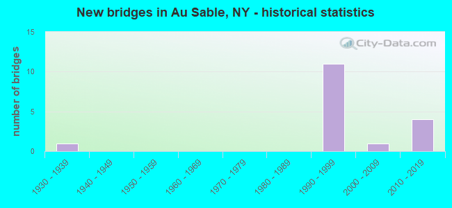
- New bridges - historical statistics
- 11930-1939
- 111990-1999
- 12000-2009
- 42010-2019


- Bridge Condition - Deck
- 25.0%Very good
- 62.5%Good
- 12.5%Satisfactory

- Bridge Condition - Superstructure
- 22.2%Excellent
- 33.3%Very good
- 33.3%Good
- 11.1%Fair

- Bridge Condition - Substructure
- 33.3%Excellent
- 22.2%Very good
- 33.3%Good
- 11.1%Satisfactory

- Bridge Condition - Channel
- 33.3%Very good
- 33.3%Good
- 33.3%Satisfactory
Find on map >> Show street view
Structure Number: 1007041, Location: JCT SH 9N & I87 SB (Lat: 44.495153, Lng: -73.500058), Route carried "on" structure: Interstate 87, Year Built: 1996, Status: Open, Structure Length: 3.57m (11.71ft), Average Daily Traffic: 4,639 (year 2015), Truck Traffic: 15%, Average Future Daily Traffic: 6,495 (year 2035), Design Load: HS 25 or greater, Features Intersected: RTE 9N
Minimum Vertical Clearance: 30+ m (98+ ft), Kilometerpoint: 0.628, Lanes on structure: 3, Lanes under structure: 2, Base Highway Network: Yes, Owner: State Highway Agency, Approaching Roadway Width: 16.2m (53.1ft), Skew: 1 degrees, Material/Design: Steel, Design/Construction: Stringer/Multi-beam, Number Of Spans In Main Unit: 1, Length of Maximum Span: 34.1m (111.9ft), Curb-To-Curb Width: 16.0m (52.5ft), Out-to-Out Width: 16.9m (55.4ft)
Condition: Deck: Good, Superstructure: Very good, Substructure: Good, Operating Rating: 81.6 metric tons, Method Used To Determine Operating Rating: Load Factor (LF), Inventory Rating: 42.6 metric tons, Method Used To Determine Inventory Rating: Load Factor (LF), Structural Evaluation: Better than present minimum criteria, Deck Geometry: Equal to present minimum criteria, Underclear: Equal to present minimum criteria, Approach Roadway Alignment: Equal to present desirable criteria, Length Of Structure Improvement: 3.56m (11.68ft), Designated Inspection Frequency: Every 24 months, Inspection Date: June 2020, Bridge Improvement Cost: $1,741,000, Roadway Improvement Cost: $1,020,000, Total Project Cost: $2,761,000 ( Estimate for 2021), Deck Structure Type: Concrete Cast-file-Place, Wearing Surface/Protective System: Wearing Surface: Integral Concrete, Deck Protection: Epoxy Coated Reinforcing
Find on map >> Show street view
Structure Number: 1007042, Location: JCT SH 9N & I87 NB (Lat: 44.495208, Lng: -73.499617), Route carried "on" structure: Interstate 87, Year Built: 1996, Status: Open, Structure Length: 3.57m (11.71ft), Average Daily Traffic: 2,065 (year 2015), Truck Traffic: 24%, Average Future Daily Traffic: 2,459 (year 2040), Design Load: HS 25 or greater, Features Intersected: RTE 9N
Minimum Vertical Clearance: 30+ m (98+ ft), Kilometerpoint: 0.628, Lanes on structure: 3, Lanes under structure: 2, Base Highway Network: Yes, Owner: State Highway Agency, Approaching Roadway Width: 14.9m (48.9ft), Skew: 1 degrees, Material/Design: Steel, Design/Construction: Stringer/Multi-beam, Number Of Spans In Main Unit: 1, Length of Maximum Span: 34.1m (111.9ft), Curb-To-Curb Width: 14.8m (48.6ft), Out-to-Out Width: 15.7m (51.5ft)
Condition: Deck: Good, Superstructure: Very good, Substructure: Good, Operating Rating: 81.6 metric tons, Method Used To Determine Operating Rating: Load Factor (LF), Inventory Rating: 42.6 metric tons, Method Used To Determine Inventory Rating: Load Factor (LF), Structural Evaluation: Better than present minimum criteria, Deck Geometry: Meets minimum limits, Underclear: Equal to present minimum criteria, Approach Roadway Alignment: Equal to present desirable criteria, Length Of Structure Improvement: 3.56m (11.68ft), Designated Inspection Frequency: Every 24 months, Inspection Date: June 2020, Bridge Improvement Cost: $1,497,000, Roadway Improvement Cost: $876,000, Total Project Cost: $2,373,000 ( Estimate for 2021), Deck Structure Type: Concrete Cast-file-Place, Wearing Surface/Protective System: Wearing Surface: Integral Concrete, Deck Protection: Epoxy Coated Reinforcing
Find on map >> Show street view
Structure Number: 101725, Location: 1.4 MI N JCT I87 & 9N (Lat: 44.516936, Lng: -73.498581), Route carried "on" structure: State highway 22, Year Built: 1995, Status: Open, Structure Length: 9.94m (32.61ft), Average Daily Traffic: 2,094 (year 2020), Truck Traffic: 9%, Average Future Daily Traffic: 2,184 (year 2040), Design Load: HS 25 or greater, Features Intersected: RTE I87, RTE I87
Minimum Vertical Clearance: 30+ m (98+ ft), Kilometerpoint: 2.237, Lanes on structure: 2, Lanes under structure: 4, Base Highway Network: Yes, Owner: State Highway Agency, Approaching Roadway Width: 12.2m (40.0ft), Skew: 4 degrees, Material/Design: Steel continuous, Design/Construction: Stringer/Multi-beam, Number Of Spans In Main Unit: 2, Length of Maximum Span: 48.7m (159.8ft), Curb-To-Curb Width: 11.9m (39.0ft), Out-to-Out Width: 12.8m (42.0ft)
Condition: Deck: Satisfactory, Superstructure: Good, Substructure: Excellent, Inventory Rating: 63.5 metric tons, Method Used To Determine Inventory Rating: Load Factor (LF), Structural Evaluation: Better than present minimum criteria, Deck Geometry: Somewhat better than minimum adequacy, Underclear: Somewhat better than minimum adequacy, Approach Roadway Alignment: Equal to present desirable criteria, Length Of Structure Improvement: 9.93m (32.58ft), Designated Inspection Frequency: Every 24 months, Inspection Date: July 2021, Bridge Improvement Cost: $2,733,000, Roadway Improvement Cost: $1,601,000, Total Project Cost: $4,334,000 ( Estimate for 2021), Deck Structure Type: Concrete Cast-file-Place, Wearing Surface/Protective System: Wearing Surface: Integral Concrete, Deck Protection: Epoxy Coated Reinforcing
Find on map >> Show street view
Structure Number: 1033891, Location: 5 MI S JCT I87 & SH 442 (Lat: 44.505447, Lng: -73.500564), Route carried "on" structure: Interstate 87, Year Built: 1998, Status: Open, Structure Length: 2.29m (7.51ft), Average Daily Traffic: 4,639 (year 2015), Truck Traffic: 15%, Average Future Daily Traffic: 6,495 (year 2035), Design Load: HS 25 or greater, Features Intersected: HALLOCK HILL RD CR41
Minimum Vertical Clearance: 30+ m (98+ ft), Kilometerpoint: 1.738, Lanes on structure: 2, Lanes under structure: 2, Base Highway Network: Yes, Owner: State Highway Agency, Approaching Roadway Width: 11.3m (37.1ft), Material/Design: Steel, Design/Construction: Stringer/Multi-beam, Number Of Spans In Main Unit: 1, Length of Maximum Span: 21.6m (70.9ft), Curb-To-Curb Width: 11.1m (36.4ft), Out-to-Out Width: 12.0m (39.4ft)
Condition: Deck: Good, Superstructure: Good, Substructure: Very good, Operating Rating: 75.3 metric tons, Method Used To Determine Operating Rating: Load Factor (LF), Inventory Rating: 45.4 metric tons, Method Used To Determine Inventory Rating: Load Factor (LF), Structural Evaluation: Better than present minimum criteria, Deck Geometry: Somewhat better than minimum adequacy, Underclear: High priority of corrective action, Approach Roadway Alignment: Equal to present desirable criteria, Length Of Structure Improvement: 2.28m (7.48ft), Designated Inspection Frequency: Every 24 months, Inspection Date: July 2020, Bridge Improvement Cost: $930,000, Roadway Improvement Cost: $544,000, Total Project Cost: $1,474,000 ( Estimate for 2021), Deck Structure Type: Concrete Cast-file-Place, Wearing Surface/Protective System: Wearing Surface: Integral Concrete, Deck Protection: Epoxy Coated Reinforcing
Find on map >> Show street view
Structure Number: 1033892, Location: 5 MI S JCT SH 422 & I87 (Lat: 44.505447, Lng: -73.500042), Route carried "on" structure: Interstate 87, Year Built: 1998, Status: Open, Structure Length: 2.29m (7.51ft), Average Daily Traffic: 2,065 (year 2015), Truck Traffic: 24%, Average Future Daily Traffic: 2,459 (year 2040), Design Load: HS 25 or greater, Features Intersected: HALLOCK HILL RD
Minimum Vertical Clearance: 30+ m (98+ ft), Kilometerpoint: 1.786, Lanes on structure: 2, Lanes under structure: 2, Base Highway Network: Yes, Owner: State Highway Agency, Approaching Roadway Width: 11.3m (37.1ft), Material/Design: Steel, Design/Construction: Stringer/Multi-beam, Number Of Spans In Main Unit: 1, Length of Maximum Span: 21.6m (70.9ft), Curb-To-Curb Width: 11.1m (36.4ft), Out-to-Out Width: 12.0m (39.4ft)
Condition: Deck: Good, Superstructure: Good, Substructure: Very good, Operating Rating: 75.3 metric tons, Method Used To Determine Operating Rating: Load Factor (LF), Inventory Rating: 45.4 metric tons, Method Used To Determine Inventory Rating: Load Factor (LF), Structural Evaluation: Better than present minimum criteria, Deck Geometry: Somewhat better than minimum adequacy, Underclear: Somewhat better than minimum adequacy, Approach Roadway Alignment: Equal to present desirable criteria, Length Of Structure Improvement: 2.28m (7.48ft), Designated Inspection Frequency: Every 24 months, Inspection Date: July 2020, Bridge Improvement Cost: $930,000, Roadway Improvement Cost: $544,000, Total Project Cost: $1,474,000 ( Estimate for 2021), Deck Structure Type: Concrete Cast-file-Place, Wearing Surface/Protective System: Wearing Surface: Integral Concrete, Deck Protection: Epoxy Coated Reinforcing
Find on map >> Show street view
Structure Number: 10339, Location: 2.7 MI S JCT RTS I-87+442 (Lat: 44.540358, Lng: -73.499811), Route carried "on" structure: County highway , Year Built: 2011, Status: Open, Structure Length: 3.60m (11.81ft), Average Daily Traffic: 386 (year 2017), Truck Traffic: 16%, Average Future Daily Traffic: 540 (year 2037), Design Load: HL 93, Features Intersected: RTE I87, Facility Carried by Structure: COUNTY ROAD 38
Minimum Vertical Clearance: 30+ m (98+ ft), Kilometerpoint: 2.414, Lanes on structure: 2, Lanes under structure: 2, Owner: State Highway Agency, Approaching Roadway Width: 9.8m (32.2ft), Material/Design: Steel, Design/Construction: Stringer/Multi-beam, Number Of Spans In Main Unit: 1, Length of Maximum Span: 35.4m (116.1ft), Curb-To-Curb Width: 9.4m (30.8ft), Out-to-Out Width: 10.8m (35.4ft)
Condition: Deck: Very good, Superstructure: Excellent, Substructure: Excellent, Operating Rating: 59.3 metric tons, Method Used To Determine Operating Rating: Load and Resistance Factor Rating (LRFR) rating reported by rating factor(RF) method using HL-93 loadings, Inventory Rating: 45.7 metric tons, Method Used To Determine Inventory Rating: Load and Resistance Factor Rating (LRFR) rating reported by rating factor(RF) method using HL-93 loadings, Structural Evaluation: Superior to present desirable criteria, Deck Geometry: Equal to present minimum criteria, Underclear: High priority of corrective action, Approach Roadway Alignment: Equal to present desirable criteria, Length Of Structure Improvement: 3.59m (11.78ft), Designated Inspection Frequency: Every 24 months, Inspection Date: May 2021, Bridge Improvement Cost: $764,000, Roadway Improvement Cost: $447,000, Total Project Cost: $1,211,000 ( Estimate for 2021), Deck Structure Type: Concrete Cast-file-Place, Wearing Surface/Protective System: Wearing Surface: Integral Concrete, Deck Protection: Epoxy Coated Reinforcing
Find on map >> Show street view
Structure Number: 10713, Location: 2MI NE OF KEESEVILLE (Lat: 44.524733, Lng: -73.463164), Route carried "on" structure: US 9, Year Built: 1934, Year Reconstructed: 1991, Status: Open, Structure Length: 12.53m (41.11ft), Average Daily Traffic: 2,459 (year 2016), Truck Traffic: 5%, Average Future Daily Traffic: 2,622 (year 2040), Design Load: HS 20, Features Intersected: AUSABLE RIVER, DRIVEWAY,
Minimum Vertical Clearance: 30+ m (98+ ft), Kilometerpoint: 0.000, Lanes on structure: 2, Lanes under structure: 2, Base Highway Network: Yes, Owner: State Highway Agency, Approaching Roadway Width: 9.1m (29.9ft), Material/Design: Steel, Design/Construction: Arch - Deck, Number Of Spans In Main Unit: 3, Length of Maximum Span: 69.5m (228.0ft), Curb or Sidewalk Widths: Left: 1.5m (4.9ft), Right: 1.5m (4.9ft), Curb-To-Curb Width: 9.1m (29.9ft), Out-to-Out Width: 12.7m (41.7ft)
Condition: Deck: Good, Superstructure: Fair, Substructure: Satisfactory, Channel: Very good, Operating Rating: 61.7 metric tons, Method Used To Determine Operating Rating: Load Factor (LF), Inventory Rating: 37.2 metric tons, Method Used To Determine Inventory Rating: Load Factor (LF), Structural Evaluation: Somewhat better than minimum adequacy, Deck Geometry: Meets minimum limits, Underclear: High priority of corrective action, Waterway Adequacy: Equal to present minimum criteria, Approach Roadway Alignment: Equal to present desirable criteria, Length Of Structure Improvement: 12.52m (41.08ft), Designated Inspection Frequency: Every 24 months, Critical Feature Inspection Frequency: Every 12 months, Inspection Date: July 2021, Critical Feature Inspection Date: July 2021, Bridge Improvement Cost: $7,611,000, Roadway Improvement Cost: $4,457,000, Total Project Cost: $12,068,000 ( Estimate for 2021), Deck Structure Type: Concrete Cast-file-Place, Wearing Surface/Protective System: Wearing Surface: Integral Concrete, Deck Protection: Epoxy Coated Reinforcing
Find on map >> Show street view
Structure Number: 109473, Location: 2.6 MI S JCT I87NB & SH 4 (Lat: 44.540431, Lng: -73.498953), Route carried "on" structure: County highway , Year Built: 2011, Status: Open, Structure Length: 3.60m (11.81ft), Average Daily Traffic: 386 (year 2017), Truck Traffic: 16%, Average Future Daily Traffic: 540 (year 2037), Design Load: HL 93, Features Intersected: RTE I87, Facility Carried by Structure: CR 38
Minimum Vertical Clearance: 30+ m (98+ ft), Kilometerpoint: 2.446, Lanes on structure: 2, Lanes under structure: 2, Owner: State Highway Agency, Approaching Roadway Width: 9.4m (30.8ft), Material/Design: Steel, Design/Construction: Stringer/Multi-beam, Number Of Spans In Main Unit: 1, Length of Maximum Span: 35.4m (116.1ft), Curb-To-Curb Width: 9.6m (31.5ft), Out-to-Out Width: 10.8m (35.4ft)
Condition: Deck: Very good, Superstructure: Excellent, Substructure: Excellent, Operating Rating: 59.3 metric tons, Method Used To Determine Operating Rating: Load and Resistance Factor Rating (LRFR) rating reported by rating factor(RF) method using HL-93 loadings, Inventory Rating: 45.7 metric tons, Method Used To Determine Inventory Rating: Load and Resistance Factor Rating (LRFR) rating reported by rating factor(RF) method using HL-93 loadings, Structural Evaluation: Superior to present desirable criteria, Deck Geometry: Equal to present minimum criteria, Underclear: High priority of corrective action, Approach Roadway Alignment: Equal to present desirable criteria, Length Of Structure Improvement: 3.59m (11.78ft), Designated Inspection Frequency: Every 24 months, Inspection Date: May 2021, Bridge Improvement Cost: $764,000, Roadway Improvement Cost: $447,000, Total Project Cost: $1,211,000 ( Estimate for 2021), Deck Structure Type: Concrete Cast-file-Place, Wearing Surface/Protective System: Wearing Surface: Integral Concrete, Deck Protection: Epoxy Coated Reinforcing
Find on map >> Show street view
Structure Number: 333594, Location: .2 MI W HARKNESS (Lat: 44.525464, Lng: -73.574008), Route carried "on" structure: County highway , Year Built: 2005, Status: Open, Structure Length: 1.01m (3.31ft), Average Daily Traffic: 449 (year 2020), Truck Traffic: 6%, Average Future Daily Traffic: 629 (year 2040), Design Load: HS 25 or greater, Features Intersected: Lit Ausable River, Facility Carried by Structure: CR 40 CALKINS RD
Minimum Vertical Clearance: 30+ m (98+ ft), Kilometerpoint: 3.878, Lanes on structure: 2, Owner: County Highway Agency, Approaching Roadway Width: 7.9m (25.9ft), Material/Design: Concrete, Design/Construction: Frame, Number Of Spans In Main Unit: 1, Length of Maximum Span: 9.8m (32.2ft), Curb-To-Curb Width: 7.8m (25.6ft), Out-to-Out Width: 8.0m (26.2ft)
Condition: Superstructure: Very good, Substructure: Good, Channel: Satisfactory, Operating Rating: 79.5 metric tons, Method Used To Determine Operating Rating: Field evaluation and documented engineering judgment, Inventory Rating: 40.8 metric tons, Method Used To Determine Inventory Rating: Field evaluation and documented engineering judgment, Structural Evaluation: Better than present minimum criteria, Deck Geometry: Meets minimum limits, Waterway Adequacy: Somewhat better than minimum adequacy, Approach Roadway Alignment: Equal to present desirable criteria, Length Of Structure Improvement: 1.00m (3.28ft), Designated Inspection Frequency: Every 24 months, Inspection Date: August 2020, Bridge Improvement Cost: $161,000, Roadway Improvement Cost: $94,000, Total Project Cost: $255,000 ( Estimate for 2021), Wearing Surface/Protective System: Wearing Surface: Bituminous
Find on map >> Show street view
Structure Number: 333595, Location: 0.2 MI N FERRONA (Lat: 44.491392, Lng: -73.593928), Route carried "on" structure: County highway , Year Built: 1999, Status: Open, Structure Length: 1.13m (3.71ft), Average Daily Traffic: 1,367 (year 2017), Truck Traffic: 8%, Average Future Daily Traffic: 1,914 (year 2037), Design Load: HS 25 or greater, Features Intersected: LITTLE AUSABLE RV, Facility Carried by Structure: CLINTONVILLE ROAD
Minimum Vertical Clearance: 30+ m (98+ ft), Kilometerpoint: 3.105, Lanes on structure: 2, Owner: County Highway Agency, Approaching Roadway Width: 8.5m (27.9ft), Material/Design: Concrete, Design/Construction: Culvert, Number Of Spans In Main Unit: 1, Length of Maximum Span: 10.9m (35.8ft)
Condition: Channel: Good, Culverts: Very good, Operating Rating: 80.4 metric tons, Method Used To Determine Operating Rating: Field evaluation and documented engineering judgment, Inventory Rating: 40.8 metric tons, Method Used To Determine Inventory Rating: Field evaluation and documented engineering judgment, Structural Evaluation: Equal to present desirable criteria, Waterway Adequacy: Equal to present minimum criteria, Approach Roadway Alignment: Equal to present desirable criteria, Length Of Structure Improvement: 1.12m (3.67ft), Designated Inspection Frequency: Every 24 months, Inspection Date: May 2021, Bridge Improvement Cost: $193,000, Roadway Improvement Cost: $113,000, Total Project Cost: $305,000 ( Estimate for 2021)
Find on map >> Show street view
Structure Number: 1007041, Location: JCT SH 9N & I87 SB (Lat: 44.495153, Lng: -73.500058), Route carried "under" structure: State highway 9N, Year Built: 1996, Structure Length: 0. m, Average Daily Traffic: 3,729 (year 1999), Features Intersected: RTE 9N, Facility Carried by Structure: RTE I87
Minimum Vertical Clearance: 5.30m (17.39ft), Kilometerpoint: 16.718, Lanes on structure: 3, Lanes under structure: 2, Material/Design: Steel, Design/Construction: Stringer/Multi-beam, Length of Maximum Span: 34.1m (111.9ft)
Find on map >> Show street view
Structure Number: 1007042, Location: JCT SH 9N & I87 NB (Lat: 44.495208, Lng: -73.499617), Route carried "under" structure: State highway 9N, Year Built: 1996, Structure Length: 0. m, Average Daily Traffic: 3,729 (year 1999), Features Intersected: RTE 9N, Facility Carried by Structure: RTE I87
Minimum Vertical Clearance: 5.15m (16.90ft), Kilometerpoint: 16.718, Lanes on structure: 3, Lanes under structure: 2, Material/Design: Steel, Design/Construction: Stringer/Multi-beam, Length of Maximum Span: 34.1m (111.9ft)
Find on map >> Show street view
Structure Number: 101725, Location: 1.4 MI N JCT I87 & 9N (Lat: 44.516936, Lng: -73.498581), Route carried "under" structure: Interstate 87, Year Built: 1995, Structure Length: 0. m, Average Daily Traffic: 9,000 (year 1993), Features Intersected: RTE I87, RTE I87, Facility Carried by Structure: RTE 22
Minimum Vertical Clearance: 5.08m (16.67ft), Kilometerpoint: 2.092, Lanes on structure: 2, Lanes under structure: 2, Material/Design: Steel continuous, Design/Construction: Stringer/Multi-beam, Length of Maximum Span: 48.7m (159.8ft)
Find on map >> Show street view
Structure Number: 1033891, Location: 5 MI S JCT I87 & SH 442 (Lat: 44.505447, Lng: -73.500564), Route carried "under" structure: County highway , Year Built: 1998, Structure Length: 0. m, Average Daily Traffic: 527 (year 2007), Features Intersected: HALLOCK HILL RD CR41, Facility Carried by Structure: RTE I87
Minimum Vertical Clearance: 4.32m (14.17ft), Kilometerpoint: 0.000, Lanes on structure: 2, Lanes under structure: 2, Material/Design: Steel, Design/Construction: Stringer/Multi-beam, Length of Maximum Span: 21.6m (70.9ft)
Find on map >> Show street view
Structure Number: 1033892, Location: 5 MI S JCT SH 422 & I87 (Lat: 44.505447, Lng: -73.500042), Route carried "under" structure: County highway , Year Built: 1998, Structure Length: 0. m, Average Daily Traffic: 527 (year 2007), Features Intersected: HALLOCK HILL RD, Facility Carried by Structure: RTE I87
Minimum Vertical Clearance: 4.45m (14.60ft), Kilometerpoint: 0.000, Lanes on structure: 2, Lanes under structure: 2, Material/Design: Steel, Design/Construction: Stringer/Multi-beam, Length of Maximum Span: 21.6m (70.9ft)
Find on map >> Show street view
Structure Number: 10339, Location: 2.7 MI S JCT RTS I-87+442 (Lat: 44.540358, Lng: -73.499811), Route carried "under" structure: Interstate 87, Year Built: 2011, Structure Length: 0. m, Average Daily Traffic: 6,000 (year 1979), Features Intersected: RTE I87, Facility Carried by Structure: COUNTY ROAD 38
Minimum Vertical Clearance: 5.36m (17.59ft), Kilometerpoint: 5.712, Lanes on structure: 2, Lanes under structure: 2, Material/Design: Steel, Design/Construction: Stringer/Multi-beam, Length of Maximum Span: 35.4m (116.1ft)
Find on map >> Show street view
Structure Number: 109473, Location: 2.6 MI S JCT I87NB & SH 4 (Lat: 44.540431, Lng: -73.498953), Route carried "under" structure: Interstate 87, Year Built: 2011, Structure Length: 0. m, Average Daily Traffic: 6,000 (year 1979), Features Intersected: RTE I87, Facility Carried by Structure: CR 38
Minimum Vertical Clearance: 5.44m (17.85ft), Kilometerpoint: 5.712, Lanes on structure: 2, Lanes under structure: 2, Material/Design: Steel, Design/Construction: Stringer/Multi-beam, Length of Maximum Span: 35.4m (116.1ft)