Bridge Statistics for Annsville, New York (NY)
Condition, Traffic, Stress, Structural Evaluation, Project Costs
- National Bridge Inventory (NBI) Statistics
- 17Number of bridges
- 138ft / 42.2mTotal length
- $14,584,000Total costs
- 22,399Total average daily traffic
- 1,454Total average daily truck traffic
- National Bridge Inventory (NBI) Registered Bridges for Annsville
- No street view available for this location
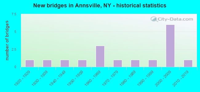
- New bridges - historical statistics
- 11920-1929
- 11930-1939
- 11940-1949
- 11950-1959
- 31960-1969
- 11970-1979
- 11980-1989
- 11990-1999
- 62000-2009
- 12010-2019

- Reconstructed bridges - Historical Statistics
- 21980-1989
- 11990-1999
- 12000-2009


- Bridge Condition - Deck
- 21.4%Excellent
- 42.9%Very good
- 7.1%Good
- 7.1%Satisfactory
- 21.4%Fair

- Bridge Condition - Superstructure
- 28.6%Excellent
- 50.0%Very good
- 14.3%Good
- 7.1%Poor

- Bridge Condition - Substructure
- 21.4%Excellent
- 35.7%Very good
- 21.4%Good
- 14.3%Fair
- 7.1%Poor

- Bridge Condition - Channel
- 40.0%Good
- 20.0%Satisfactory
- 40.0%Fair

- Bridge Condition - Culverts
- 50.0%Satisfactory
- 50.0%Fair
Find on map >> Show street view
Structure Number: 102937, Location: 7.4 MI SE JCT SH13 & SH69 (Lat: 43.302019, Lng: -75.619461), Route carried "on" structure: State highway 69, Year Built: 2003, Status: Open, Structure Length: 6.13m (20.11ft), Average Daily Traffic: 6,559 (year 2020), Truck Traffic: 7%, Average Future Daily Traffic: 6,599 (year 2040), Design Load: HS 25 or greater, Features Intersected: E BRANCH FISH CRK
Minimum Vertical Clearance: 30+ m (98+ ft), Kilometerpoint: 22.397, Lanes on structure: 2, Base Highway Network: Yes, Owner: State Highway Agency, Approaching Roadway Width: 12.2m (40.0ft), Material/Design: Steel, Design/Construction: Stringer/Multi-beam, Number Of Spans In Main Unit: 1, Length of Maximum Span: 60.0m (196.9ft), Curb-To-Curb Width: 12.3m (40.4ft), Out-to-Out Width: 13.3m (43.6ft)
Condition: Deck: Very good, Superstructure: Very good, Substructure: Very good, Channel: Good, Operating Rating: 92.5 metric tons, Method Used To Determine Operating Rating: Load Factor (LF), Inventory Rating: 55.3 metric tons, Method Used To Determine Inventory Rating: Load Factor (LF), Structural Evaluation: Equal to present desirable criteria, Deck Geometry: Somewhat better than minimum adequacy, Waterway Adequacy: Equal to present minimum criteria, Approach Roadway Alignment: Equal to present desirable criteria, Length Of Structure Improvement: 6.12m (20.08ft), Designated Inspection Frequency: Every 24 months, Inspection Date: May 2021, Bridge Improvement Cost: $1,786,000, Roadway Improvement Cost: $1,046,000, Total Project Cost: $2,831,000 ( Estimate for 2021), Deck Structure Type: Concrete Cast-file-Place, Wearing Surface/Protective System: Wearing Surface: Monolithic Concrete, Deck Protection: Epoxy Coated Reinforcing
Find on map >> Show street view
Structure Number: 107824, Location: 7.4 MI SE JCT SH13 & SH69 (Lat: 43.302392, Lng: -75.619733), Route carried "on" structure: State highway 69, Year Built: 2003, Status: Open, Structure Length: 1.40m (4.59ft), Average Daily Traffic: 7,617 (year 2016), Truck Traffic: 7%, Average Future Daily Traffic: 7,693 (year 2038), Design Load: HS 25 or greater, Features Intersected: BLOSSVALE ROAD
Minimum Vertical Clearance: 30+ m (98+ ft), Kilometerpoint: 22.365, Lanes on structure: 2, Lanes under structure: 2, Base Highway Network: Yes, Owner: State Highway Agency, Approaching Roadway Width: 11.9m (39.0ft), Material/Design: Concrete, Design/Construction: Arch - Deck, Number Of Spans In Main Unit: 1, Length of Maximum Span: 12.8m (42.0ft), Curb-To-Curb Width: 12.0m (39.4ft), Out-to-Out Width: 13.3m (43.6ft)
Condition: Deck: Excellent, Superstructure: Excellent, Substructure: Very good, Operating Rating: 98.0 metric tons, Method Used To Determine Operating Rating: Load Factor (LF), Inventory Rating: 59.0 metric tons, Method Used To Determine Inventory Rating: Load Factor (LF), Structural Evaluation: Equal to present desirable criteria, Deck Geometry: Somewhat better than minimum adequacy, Underclear: Somewhat better than minimum adequacy, Approach Roadway Alignment: Equal to present desirable criteria, Length Of Structure Improvement: 1.40m (4.59ft), Designated Inspection Frequency: Every 24 months, Inspection Date: June 2021, Bridge Improvement Cost: $640,000, Roadway Improvement Cost: $375,000, Total Project Cost: $1,014,000 ( Estimate for 2021), Wearing Surface/Protective System: Wearing Surface: Bituminous, Membrane: Other
Find on map >> Show street view
Structure Number: 220529, Location: 1.5 MI NE OF TABERG (Lat: 43.315653, Lng: -75.595417), Route carried "on" structure: Other road , Year Built: 1972, Status: Open, Structure Length: 6.64m (21.78ft), Average Daily Traffic: 339 (year 2019), Truck Traffic: 4%, Average Future Daily Traffic: 475 (year 2039), Design Load: H 20, Features Intersected: E BR FISH CREEK, Facility Carried by Structure: PALMER ROAD
Minimum Vertical Clearance: 30+ m (98+ ft), Kilometerpoint: 0.885, Lanes on structure: 2, Owner: Town or Township Highway Agency, Approaching Roadway Width: 5.8m (19.0ft), Skew: 2 degrees, Material/Design: Steel continuous, Design/Construction: Stringer/Multi-beam, Number Of Spans In Main Unit: 3, Length of Maximum Span: 24.6m (80.7ft), Curb-To-Curb Width: 7.9m (25.9ft), Out-to-Out Width: 8.6m (28.2ft)
Condition: Deck: Very good, Superstructure: Very good, Substructure: Good, Channel: Satisfactory, Operating Rating: 37.9 metric tons, Method Used To Determine Operating Rating: Load and Resistance Factor Rating (LRFR) rating reported by rating factor(RF) method using HL-93 loadings, Inventory Rating: 29.2 metric tons, Method Used To Determine Inventory Rating: Load and Resistance Factor Rating (LRFR) rating reported by rating factor(RF) method using HL-93 loadings, Structural Evaluation: Better than present minimum criteria, Deck Geometry: Somewhat better than minimum adequacy, Waterway Adequacy: Meets minimum limits, Approach Roadway Alignment: Somewhat better than minimum adequacy, Length Of Structure Improvement: 6.64m (21.78ft), Designated Inspection Frequency: Every 24 months, Inspection Date: October 2020, Bridge Improvement Cost: $1,000,000, Roadway Improvement Cost: $585,000, Total Project Cost: $1,585,000 ( Estimate for 2021), Deck Structure Type: Concrete Cast-file-Place, Wearing Surface/Protective System: Wearing Surface: Bituminous
Find on map >> Show street view
Structure Number: 22053, Location: 8 MI NORTH OF TABERG (Lat: 43.391614, Lng: -75.599508), Route carried "on" structure: Other road , Year Built: 1965, Status: Closed, Structure Length: 0.91m (2.99ft), Average Daily Traffic: 34 (year 2016), Truck Traffic: 7%, Average Future Daily Traffic: 48 (year 2036), Design Load: HS 20, Features Intersected: FALL BROOK, Facility Carried by Structure: GOSSNER ROAD
Minimum Vertical Clearance: 30+ m (98+ ft), Kilometerpoint: 1.319, Lanes on structure: 2, Owner: Town or Township Highway Agency, Approaching Roadway Width: 5.5m (18.0ft), Material/Design: Steel, Design/Construction: Stringer/Multi-beam, Number Of Spans In Main Unit: 1, Length of Maximum Span: 8.5m (27.9ft), Curb-To-Curb Width: 7.2m (23.6ft), Out-to-Out Width: 7.9m (25.9ft)
Condition: Deck: Good, Superstructure: Good, Substructure: Good, Channel: Fair, Deck Geometry: Somewhat better than minimum adequacy, Waterway Adequacy: Meets minimum limits, Approach Roadway Alignment: Equal to present minimum criteria, Bridge Posting: Required (Relationship of Operating Rating to Maximum Legal Load: > 39.9% below), Length Of Structure Improvement: 0.91m (2.99ft), Designated Inspection Frequency: Every 24 months, Inspection Date: June 2020, Bridge Improvement Cost: $297,000, Roadway Improvement Cost: $174,000, Total Project Cost: $470,000 ( Estimate for 2021), Deck Structure Type: Concrete Cast-file-Place, Wearing Surface/Protective System: Wearing Surface: Bituminous
Find on map >> Show street view
Structure Number: 220531, Location: 4.25 MILES N OF TABERG (Lat: 43.378603, Lng: -75.636394), Route carried "on" structure: Other road , Year Built: 1963, Year Reconstructed: 1993, Status: Posted for load, Structure Length: 1.04m (3.41ft), Average Daily Traffic: 72 (year 2019), Truck Traffic: 4%, Average Future Daily Traffic: 101 (year 2039), Features Intersected: FLORENCE CREEK, Facility Carried by Structure: BLAKE ROAD
Minimum Vertical Clearance: 30+ m (98+ ft), Kilometerpoint: 3.717, Lanes on structure: 1, Owner: Town or Township Highway Agency, Approaching Roadway Width: 5.2m (17.1ft), Material/Design: Steel, Design/Construction: Stringer/Multi-beam, Number Of Spans In Main Unit: 1, Length of Maximum Span: 9.1m (29.9ft), Curb-To-Curb Width: 5.3m (17.4ft), Out-to-Out Width: 5.6m (18.4ft)
Condition: Deck: Fair, Superstructure: Poor, Substructure: Poor, Channel: Good, Operating Rating: 15.4 metric tons, Method Used To Determine Operating Rating: Load Factor (LF), Inventory Rating: 9.1 metric tons, Method Used To Determine Inventory Rating: Load Factor (LF), Structural Evaluation: High priority of corrective action, Deck Geometry: High priority of corrective action, Waterway Adequacy: Meets minimum limits, Approach Roadway Alignment: Equal to present minimum criteria, Bridge Posting: Required (Relationship of Operating Rating to Maximum Legal Load: > 39.9% below), Length Of Structure Improvement: 1.03m (3.38ft), Designated Inspection Frequency: Every 12 months, Inspection Date: April 2021, Bridge Improvement Cost: $122,000, Roadway Improvement Cost: $72,000, Total Project Cost: $194,000 ( Estimate for 2021), Deck Structure Type: Wood or Timber, Wearing Surface/Protective System: Wearing Surface: Wood or Timber
Find on map >> Show street view
Structure Number: 220533, Location: 2 MI NE OF TABERG (Lat: 43.332047, Lng: -75.593719), Route carried "on" structure: Other road , Year Built: 1962, Status: Open, Structure Length: 0.64m (2.10ft), Average Daily Traffic: 304 (year 2016), Truck Traffic: 4%, Average Future Daily Traffic: 426 (year 2036), Design Load: H 20, Features Intersected: FLORENCE CREEK, Facility Carried by Structure: COAL HILL ROAD
Minimum Vertical Clearance: 30+ m (98+ ft), Kilometerpoint: 3.588, Lanes on structure: 2, Owner: Town or Township Highway Agency, Approaching Roadway Width: 6.7m (22.0ft), Material/Design: Steel, Design/Construction: Culvert, Number Of Spans In Main Unit: 1, Length of Maximum Span: 6.0m (19.7ft)
Condition: Channel: Fair, Culverts: Fair, Operating Rating: 72.5 metric tons, Method Used To Determine Operating Rating: Field evaluation and documented engineering judgment, Inventory Rating: 19.6 metric tons, Method Used To Determine Inventory Rating: Field evaluation and documented engineering judgment, Structural Evaluation: Somewhat better than minimum adequacy, Waterway Adequacy: Meets minimum limits, Approach Roadway Alignment: Equal to present minimum criteria, Length Of Structure Improvement: 0.64m (2.10ft), Designated Inspection Frequency: Every 24 months, Inspection Date: October 2020, Bridge Improvement Cost: $84,000, Roadway Improvement Cost: $49,000, Total Project Cost: $133,000 ( Estimate for 2021)
Find on map >> Show street view
Structure Number: 220534, Location: TABERG (Lat: 43.303844, Lng: -75.617047), Route carried "on" structure: Other road , Year Built: 1985, Status: Open, Structure Length: 1.68m (5.51ft), Average Daily Traffic: 1,968 (year 2016), Truck Traffic: 6%, Average Future Daily Traffic: 2,755 (year 2036), Design Load: HS 20, Features Intersected: FURNACE CREEK, Facility Carried by Structure: MAIN STREET
Minimum Vertical Clearance: 30+ m (98+ ft), Kilometerpoint: 0.418, Lanes on structure: 2, Owner: Town or Township Highway Agency, Approaching Roadway Width: 9.1m (29.9ft), Skew: 5 degrees, Material/Design: Prestressed concrete, Design/Construction: Box Beam or Girders - Multiple, Number Of Spans In Main Unit: 1, Length of Maximum Span: 14.0m (45.9ft), Curb or Sidewalk Widths: Left: 0.0m, Right: 1.5m (4.9ft), Curb-To-Curb Width: 9.1m (29.9ft), Out-to-Out Width: 11.6m (38.1ft)
Condition: Deck: Very good, Superstructure: Very good, Substructure: Very good, Channel: Good, Operating Rating: 81.0 metric tons, Method Used To Determine Operating Rating: Load and Resistance Factor Rating (LRFR) rating reported by rating factor(RF) method using HL-93 loadings, Inventory Rating: 39.9 metric tons, Method Used To Determine Inventory Rating: Load and Resistance Factor Rating (LRFR) rating reported by rating factor(RF) method using HL-93 loadings, Structural Evaluation: Equal to present desirable criteria, Deck Geometry: Somewhat better than minimum adequacy, Waterway Adequacy: Meets minimum limits, Approach Roadway Alignment: Equal to present desirable criteria, Length Of Structure Improvement: 1.67m (5.48ft), Designated Inspection Frequency: Every 24 months, Inspection Date: May 2020, Bridge Improvement Cost: $570,000, Roadway Improvement Cost: $334,000, Total Project Cost: $905,000 ( Estimate for 2021), Deck Structure Type: Concrete Cast-file-Place, Wearing Surface/Protective System: Wearing Surface: Bituminous
Find on map >> Show street view
Structure Number: 220535, Location: 1 MI W JCT SH 69 & SH 285 (Lat: 43.302053, Lng: -75.618133), Route carried "on" structure: Other road , Year Built: 2009, Status: Open, Structure Length: 3.63m (11.91ft), Average Daily Traffic: 1,968 (year 2016), Truck Traffic: 6%, Average Future Daily Traffic: 2,755 (year 2036), Design Load: HL 93, Features Intersected: E BR FISH CREEK, Facility Carried by Structure: MAIN STREET
Minimum Vertical Clearance: 30+ m (98+ ft), Kilometerpoint: 0.177, Lanes on structure: 2, Owner: Town or Township Highway Agency, Approaching Roadway Width: 8.5m (27.9ft), Material/Design: Steel, Design/Construction: Stringer/Multi-beam, Number Of Spans In Main Unit: 1, Length of Maximum Span: 35.0m (114.8ft), Curb or Sidewalk Widths: Left: 1.7m (5.6ft), Right: 1.7m (5.6ft), Curb-To-Curb Width: 8.4m (27.6ft), Out-to-Out Width: 12.5m (41.0ft)
Condition: Deck: Excellent, Superstructure: Excellent, Substructure: Very good, Channel: Fair, Operating Rating: 53.8 metric tons, Method Used To Determine Operating Rating: Load and Resistance Factor Rating (LRFR) rating reported by rating factor(RF) method using HL-93 loadings, Inventory Rating: 41.5 metric tons, Method Used To Determine Inventory Rating: Load and Resistance Factor Rating (LRFR) rating reported by rating factor(RF) method using HL-93 loadings, Structural Evaluation: Equal to present desirable criteria, Deck Geometry: Meets minimum limits, Waterway Adequacy: Somewhat better than minimum adequacy, Approach Roadway Alignment: Equal to present desirable criteria, Length Of Structure Improvement: 3.62m (11.88ft), Designated Inspection Frequency: Every 24 months, Inspection Date: August 2021, Bridge Improvement Cost: $959,000, Roadway Improvement Cost: $562,000, Total Project Cost: $1,521,000 ( Estimate for 2021), Deck Structure Type: Concrete Cast-file-Place, Wearing Surface/Protective System: Wearing Surface: Integral Concrete, Deck Protection: Epoxy Coated Reinforcing
Find on map >> Show street view
Structure Number: 220536, Location: 0.5 MI NORTH OF TABERG (Lat: 43.309028, Lng: -75.618219), Route carried "on" structure: Other road , Year Built: 1929, Year Reconstructed: 1992, Status: Open, Structure Length: 1.28m (4.20ft), Average Daily Traffic: 1,173 (year 2016), Truck Traffic: 4%, Average Future Daily Traffic: 1,642 (year 2036), Design Load: HS 20, Features Intersected: FURNACE CREEK, Facility Carried by Structure: MAIN STREET
Minimum Vertical Clearance: 30+ m (98+ ft), Kilometerpoint: 1.078, Lanes on structure: 2, Owner: Town or Township Highway Agency, Approaching Roadway Width: 9.1m (29.9ft), Skew: 4 degrees, Material/Design: Prestressed concrete, Design/Construction: Box Beam or Girders - Multiple, Number Of Spans In Main Unit: 1, Length of Maximum Span: 11.8m (38.7ft), Curb-To-Curb Width: 9.1m (29.9ft), Out-to-Out Width: 10.1m (33.1ft)
Condition: Deck: Fair, Superstructure: Good, Substructure: Fair, Channel: Fair, Operating Rating: 89.8 metric tons, Method Used To Determine Operating Rating: Load Factor (LF), Inventory Rating: 53.5 metric tons, Method Used To Determine Inventory Rating: Load Factor (LF), Structural Evaluation: Somewhat better than minimum adequacy, Deck Geometry: Somewhat better than minimum adequacy, Waterway Adequacy: Somewhat better than minimum adequacy, Approach Roadway Alignment: Equal to present desirable criteria, Length Of Structure Improvement: 1.28m (4.20ft), Designated Inspection Frequency: Every 24 months, Inspection Date: August 2020, Bridge Improvement Cost: $561,000, Roadway Improvement Cost: $329,000, Total Project Cost: $890,000 ( Estimate for 2021), Deck Structure Type: Concrete Cast-file-Place, Wearing Surface/Protective System: Wearing Surface: Monolithic Concrete, Deck Protection: Epoxy Coated Reinforcing
Find on map >> Show street view
Structure Number: 331034, Location: 2.5 MILES SW OF TABERG (Lat: 43.268908, Lng: -75.639872), Route carried "on" structure: County highway , Year Built: 2007, Status: Open, Structure Length: 4.21m (13.81ft), Average Daily Traffic: 344 (year 2018), Truck Traffic: 11%, Average Future Daily Traffic: 482 (year 2038), Design Load: HS 25 or greater, Features Intersected: W BR FISH CREEK, Facility Carried by Structure: CR66 BLOSSVALE ROA
Minimum Vertical Clearance: 30+ m (98+ ft), Kilometerpoint: 2.912, Lanes on structure: 2, Owner: County Highway Agency, Approaching Roadway Width: 7.9m (25.9ft), Skew: 3 degrees, Material/Design: Steel, Design/Construction: Stringer/Multi-beam, Number Of Spans In Main Unit: 1, Length of Maximum Span: 41.5m (136.2ft), Curb-To-Curb Width: 7.8m (25.6ft), Out-to-Out Width: 8.8m (28.9ft)
Condition: Deck: Very good, Superstructure: Excellent, Substructure: Excellent, Channel: Satisfactory, Operating Rating: 77.1 metric tons, Method Used To Determine Operating Rating: Load Factor (LF), Inventory Rating: 46.3 metric tons, Method Used To Determine Inventory Rating: Load Factor (LF), Structural Evaluation: Superior to present desirable criteria, Deck Geometry: Somewhat better than minimum adequacy, Waterway Adequacy: Somewhat better than minimum adequacy, Approach Roadway Alignment: Better than present minimum criteria, Length Of Structure Improvement: 4.20m (13.78ft), Designated Inspection Frequency: Every 24 months, Inspection Date: August 2021, Bridge Improvement Cost: $676,000, Roadway Improvement Cost: $396,000, Total Project Cost: $1,072,000 ( Estimate for 2021), Deck Structure Type: Concrete Cast-file-Place, Wearing Surface/Protective System: Wearing Surface: Integral Concrete, Deck Protection: Epoxy Coated Reinforcing
Find on map >> Show street view
Structure Number: 331035, Location: 5 MILES N OF TABERG (Lat: 43.376503, Lng: -75.589608), Route carried "on" structure: County highway , Year Built: 1999, Status: Open, Structure Length: 1.16m (3.81ft), Average Daily Traffic: 138 (year 2018), Truck Traffic: 8%, Average Future Daily Traffic: 143 (year 2040), Design Load: HS 25 or greater, Features Intersected: FALL BROOK, Facility Carried by Structure: SHEEHAN ROAD
Minimum Vertical Clearance: 30+ m (98+ ft), Kilometerpoint: 10.040, Lanes on structure: 2, Owner: County Highway Agency, Approaching Roadway Width: 7.9m (25.9ft), Material/Design: Prestressed concrete, Design/Construction: Box Beam or Girders - Multiple, Number Of Spans In Main Unit: 1, Length of Maximum Span: 10.6m (34.8ft), Curb-To-Curb Width: 7.8m (25.6ft), Out-to-Out Width: 8.8m (28.9ft)
Condition: Deck: Satisfactory, Superstructure: Very good, Substructure: Very good, Channel: Good, Operating Rating: 77.1 metric tons, Method Used To Determine Operating Rating: Load Factor (LF), Inventory Rating: 46.3 metric tons, Method Used To Determine Inventory Rating: Load Factor (LF), Structural Evaluation: Equal to present desirable criteria, Deck Geometry: Somewhat better than minimum adequacy, Waterway Adequacy: Equal to present minimum criteria, Approach Roadway Alignment: Equal to present desirable criteria, Length Of Structure Improvement: 1.15m (3.77ft), Designated Inspection Frequency: Every 24 months, Inspection Date: April 2020, Bridge Improvement Cost: $274,000, Roadway Improvement Cost: $160,000, Total Project Cost: $434,000 ( Estimate for 2021), Wearing Surface/Protective System: Wearing Surface: Bituminous
Find on map >> Show street view
Structure Number: 331037, Location: 6 MI NE OF TABERG (Lat: 43.388786, Lng: -75.556767), Route carried "on" structure: County highway , Year Built: 1939, Year Reconstructed: 1997, Status: Open, Structure Length: 4.42m (14.50ft), Average Daily Traffic: 369 (year 2018), Truck Traffic: 9%, Average Future Daily Traffic: 384 (year 2040), Features Intersected: E BR FISH CREEK, Facility Carried by Structure: CR67A SHEEHAN ROAD
Minimum Vertical Clearance: 30+ m (98+ ft), Kilometerpoint: 15.414, Lanes on structure: 2, Owner: County Highway Agency, Approaching Roadway Width: 7.3m (24.0ft), Skew: 3 degrees, Material/Design: Wood or Timber, Design/Construction: Stringer/Multi-beam, Number Of Spans In Main Unit: 2, Length of Maximum Span: 21.9m (71.9ft), Curb-To-Curb Width: 7.2m (23.6ft), Out-to-Out Width: 7.8m (25.6ft)
Condition: Deck: Very good, Superstructure: Very good, Substructure: Good, Channel: Satisfactory, Operating Rating: 55.3 metric tons, Method Used To Determine Operating Rating: Load Factor (LF), Inventory Rating: 42.6 metric tons, Method Used To Determine Inventory Rating: Load Factor (LF), Structural Evaluation: Better than present minimum criteria, Deck Geometry: Meets minimum limits, Waterway Adequacy: Meets minimum limits, Approach Roadway Alignment: Somewhat better than minimum adequacy, Length Of Structure Improvement: 4.41m (14.47ft), Designated Inspection Frequency: Every 24 months, Inspection Date: May 2021, Bridge Improvement Cost: $673,000, Roadway Improvement Cost: $394,000, Total Project Cost: $1,067,000 ( Estimate for 2021), Deck Structure Type: Wood or Timber, Wearing Surface/Protective System: Wearing Surface: Bituminous, Membrane: Other
Find on map >> Show street view
Structure Number: 331038, Location: 2.54 MI SW OF TABERG (Lat: 43.274472, Lng: -75.650392), Route carried "on" structure: County highway , Year Built: 2007, Status: Open, Structure Length: 3.90m (12.80ft), Average Daily Traffic: 687 (year 2016), Truck Traffic: 8%, Average Future Daily Traffic: 962 (year 2036), Design Load: HS 25 or greater, Features Intersected: W BR FISH CREEK, Facility Carried by Structure: CR69 MCCONNELLSVIL
Minimum Vertical Clearance: 30+ m (98+ ft), Kilometerpoint: 3.990, Lanes on structure: 2, Owner: County Highway Agency, Approaching Roadway Width: 7.9m (25.9ft), Material/Design: Steel, Design/Construction: Stringer/Multi-beam, Number Of Spans In Main Unit: 1, Length of Maximum Span: 38.5m (126.3ft), Curb-To-Curb Width: 7.8m (25.6ft), Out-to-Out Width: 9.4m (30.8ft)
Condition: Deck: Excellent, Superstructure: Excellent, Substructure: Excellent, Channel: Good, Operating Rating: 70.8 metric tons, Method Used To Determine Operating Rating: Load Factor (LF), Inventory Rating: 41.7 metric tons, Method Used To Determine Inventory Rating: Load Factor (LF), Structural Evaluation: Superior to present desirable criteria, Deck Geometry: Meets minimum limits, Waterway Adequacy: Somewhat better than minimum adequacy, Approach Roadway Alignment: Equal to present desirable criteria, Length Of Structure Improvement: 3.90m (12.80ft), Designated Inspection Frequency: Every 24 months, Inspection Date: October 2021, Bridge Improvement Cost: $634,000, Roadway Improvement Cost: $371,000, Total Project Cost: $1,006,000 ( Estimate for 2021), Deck Structure Type: Concrete Cast-file-Place, Wearing Surface/Protective System: Wearing Surface: Integral Concrete, Deck Protection: Epoxy Coated Reinforcing
Find on map >> Show street view
Structure Number: 331039, Location: .59 MI NE JCT RTS 69<285 (Lat: 43.312608, Lng: -75.621600), Route carried "on" structure: Other road , Year Built: 1941, Status: Open, Structure Length: 0.70m (2.30ft), Average Daily Traffic: 69 (year 2017), Truck Traffic: 4%, Average Future Daily Traffic: 97 (year 2037), Design Load: H 20, Features Intersected: FURNACE CREEK, Facility Carried by Structure: GLENMORE ROAD
Minimum Vertical Clearance: 30+ m (98+ ft), Kilometerpoint: 0.241, Lanes on structure: 2, Owner: County Highway Agency, Approaching Roadway Width: 6.1m (20.0ft), Material/Design: Steel, Design/Construction: Culvert, Number Of Spans In Main Unit: 1, Length of Maximum Span: 6.0m (19.7ft)
Condition: Channel: Fair, Culverts: Satisfactory, Operating Rating: 74.1 metric tons, Method Used To Determine Operating Rating: Field evaluation and documented engineering judgment, Inventory Rating: 32.7 metric tons, Method Used To Determine Inventory Rating: Field evaluation and documented engineering judgment, Structural Evaluation: Equal to present minimum criteria, Waterway Adequacy: Meets minimum limits, Approach Roadway Alignment: Equal to present minimum criteria, Length Of Structure Improvement: 0.70m (2.30ft), Designated Inspection Frequency: Every 24 months, Inspection Date: October 2020, Bridge Improvement Cost: $83,000, Roadway Improvement Cost: $49,000, Total Project Cost: $132,000 ( Estimate for 2021)
Find on map >> Show street view
Structure Number: 33104, Location: 4 MI NE TABERG (Lat: 43.354294, Lng: -75.586178), Route carried "on" structure: Other road , Year Built: 2012, Status: Open, Structure Length: 1.92m (6.30ft), Average Daily Traffic: 304 (year 2016), Truck Traffic: 4%, Average Future Daily Traffic: 426 (year 2036), Design Load: HS 25 or greater, Features Intersected: FALL BROOK, Facility Carried by Structure: COAL HILL ROAD
Minimum Vertical Clearance: 30+ m (98+ ft), Kilometerpoint: 6.323, Lanes on structure: 2, Owner: County Highway Agency, Approaching Roadway Width: 9.4m (30.8ft), Skew: 3 degrees, Material/Design: Prestressed concrete, Design/Construction: Box Beam or Girders - Multiple, Number Of Spans In Main Unit: 1, Length of Maximum Span: 17.7m (58.1ft), Curb-To-Curb Width: 9.1m (29.9ft), Out-to-Out Width: 10.2m (33.5ft)
Condition: Deck: Very good, Superstructure: Very good, Substructure: Excellent, Channel: Good, Operating Rating: 89.8 metric tons, Method Used To Determine Operating Rating: Load Factor (LF), Inventory Rating: 53.5 metric tons, Method Used To Determine Inventory Rating: Load Factor (LF), Structural Evaluation: Equal to present desirable criteria, Deck Geometry: Equal to present minimum criteria, Waterway Adequacy: Somewhat better than minimum adequacy, Approach Roadway Alignment: Equal to present minimum criteria, Length Of Structure Improvement: 1.92m (6.30ft), Designated Inspection Frequency: Every 24 months, Inspection Date: April 2021, Bridge Improvement Cost: $402,000, Roadway Improvement Cost: $235,000, Total Project Cost: $638,000 ( Estimate for 2021), Deck Structure Type: Concrete Cast-file-Place, Wearing Surface/Protective System: Wearing Surface: Integral Concrete, Deck Protection: Epoxy Coated Reinforcing
Find on map >> Show street view
Structure Number: 331041, Location: 4 MI N OF TABERG (Lat: 43.358822, Lng: -75.618500), Route carried "on" structure: County highway , Year Built: 1953, Year Reconstructed: 2006, Status: Open, Structure Length: 2.56m (8.40ft), Average Daily Traffic: 69 (year 2017), Truck Traffic: 4%, Average Future Daily Traffic: 97 (year 2037), Design Load: HS 20, Features Intersected: FLORENCE CREEK, Facility Carried by Structure: GLENMORE ROAD
Minimum Vertical Clearance: 30+ m (98+ ft), Kilometerpoint: 5.760, Lanes on structure: 2, Owner: County Highway Agency, Approaching Roadway Width: 4.9m (16.1ft), Skew: 3 degrees, Material/Design: Steel continuous, Design/Construction: Stringer/Multi-beam, Number Of Spans In Main Unit: 3, Length of Maximum Span: 8.2m (26.9ft), Curb-To-Curb Width: 7.3m (24.0ft), Out-to-Out Width: 7.6m (24.9ft)
Condition: Deck: Fair, Superstructure: Very good, Substructure: Fair, Channel: Fair, Operating Rating: 84.4 metric tons, Method Used To Determine Operating Rating: Load Factor (LF), Inventory Rating: 50.8 metric tons, Method Used To Determine Inventory Rating: Load Factor (LF), Structural Evaluation: Somewhat better than minimum adequacy, Deck Geometry: Equal to present minimum criteria, Waterway Adequacy: Somewhat better than minimum adequacy, Approach Roadway Alignment: Equal to present desirable criteria, Length Of Structure Improvement: 2.56m (8.40ft), Designated Inspection Frequency: Every 24 months, Inspection Date: October 2020, Bridge Improvement Cost: $437,000, Roadway Improvement Cost: $256,000, Total Project Cost: $692,000 ( Estimate for 2021), Deck Structure Type: Open Grating, Wearing Surface/Protective System: Wearing Surface: Other
Find on map >> Show street view
Structure Number: 107824, Location: 7.4 MI SE JCT SH13 & SH69 (Lat: 43.302392, Lng: -75.619733), Route carried "under" structure: County highway , Year Built: 2003, Structure Length: 0. m, Average Daily Traffic: 385 (year 2000), Features Intersected: BLOSSVALE ROAD, Facility Carried by Structure: RTE 69
Minimum Vertical Clearance: 6.86m (22.51ft), Kilometerpoint: 0.000, Lanes on structure: 2, Lanes under structure: 2, Material/Design: Concrete, Design/Construction: Arch - Deck, Length of Maximum Span: 12.8m (42.0ft)